| If you notice any errors in the below information, please contact our Webmaster |
| 32 |
Flood depths in El Reno and nearby railyards would be higher than the great flood which extended from Canton to Wetumka... in October 1923. water levels are about 7 feet greater than in September 1965. downstream... the northwest edge of Yukon are flooded. In Canadian County... valley-wide overflows may affect about 50 square miles. Depths ranging up to 15 feet may destroy rural homes and properties between El Reno and Yukon. Deep... fast water on county roads creates be life-threatening conditions. |
| 31 |
Flood depths in El Reno and nearby railyards could be like the great flood which extended from Canton to Wetumka... in October 1923. water levels are about 6 feet greater than in September 1965. downstream... the northwest edge of Yukon are flooded. In Canadian County... valley-wide overflows may affect about 50 square miles. Depths ranging up to 14 feet may destroy rural homes and properties between El Reno and Yukon. Deep... fast water on county roads creates be life-threatening conditions. |
| 30 |
Flood depths in El Reno and nearby railyards could approach that of the great flood which extended from Canton to Wetumka... in October 1923. water levels are about 5 feet greater than in September 1965. downstream... the northwest edge of Yukon are flooded. In Canadian County... valley-wide overflows may affect nearly 50 square miles. Depths ranging up to 13 feet may destroy rural homes and properties between El Reno and Yukon. Deep... fast water on county roads creates be life-threatening conditions. |
| 29 |
Flood depths in El Reno and nearby railyards are the worst in recent memory... about 4 feet deeper than the flooding seen in September 1965. Downstream... the northwest edge of Yukon is affected. In Canadian County... valley-wide overflows may affect nearly 50 square miles. Depths ranging up to 12 feet severely damage rural homes and properties between El Reno and Yukon. Deep... fast water on county roads creates life-threatening conditions. |
| 28 |
Flood depths in El Reno and nearby railyards are the worst in recent memory... about 3 feet deeper than seen in September 1965. The outskirts of Yukon may be affected. In Canadian County... valley-wide overflows cover nearly 45 square miles. Depths ranging up to 11 feet severely damage rural homes and properties between El Reno and Yukon. The outskirts of Yukon may be affected. Deep... fast water on county roads creates life-threatening conditions. |
| 27 |
Flood depths in El Reno and nearby railyards are about 2 feet deeper than seen in September 1965. In Canadian County... valley-wide overflows may cover approximately 45 square miles. Depths ranging up to 10 feet severely damage rural homes and properties between El Reno and Yukon. The outskirts of Yukon may be affected. Deep... fast water on county roads creates life-threatening conditions. |
| 26 |
Flood depths in El Reno and nearby railyards are about a foot deeper than seen in September 1965. In Canadian County... valley-wide overflows may cover more than 40 square miles. Depths ranging up to 9 feet severely damage rural homes and properties between El Reno and Yukon. The outskirts of Yukon may be affected. Deep... fast water on county roads creates be life-threatening conditions. |
| 25 |
Flood depths in El Reno and nearby railyards... are like those seen in September 1965. In Canadian County... valley-wide overflows may cover more than 35 square miles. Depths ranging up to 8 feet severely damage rural homes and properties between El Reno and Yukon. The outskirts of Yukon may be affected. Deep... fast water on county and farm roads creates life-threatening conditions. |
| 24 |
Flood depths seen in El Reno and nearby railyards... are the most severe since September 1965. In Canadian County... overflows may cover more than 30 square miles. Flood depths varying up to 7 feet are very destructive to suburban and rural residences and properties between El Reno and Yukon. Other areas are isolated by life-threatening flows on county and local roads. |
| 23 |
Flood depths seen in El Reno and nearby railyards are the most severe since September 1965. In Canadian County... overflows cover approximately 30 square miles. Flood depths varying up to 6 feet are destructive to suburban and rural residences and properties between El Reno and Yukon. Other areas are isolated by life-threatening flows on county and local roads. |
| 22 |
El Reno could see significant flooding of residences and nearby railyards. In Canadian County... overflows cover about 25 square miles. Flood depths varying up to 5 feet are destructive to suburban and rural residences and properties between El Reno and Yukon. Many areas are isolated by life-threatening flows on county and local roads. |
| 21 |
Residential areas of El Reno and nearby railroad yards are affected by nuisance flooding. Downstream... nearly 20 square miles of mostly suburban areas between El Reno and Yukon are flooded to varying depths up to 4 feet. Numerous homesteads may be severely flooded or isolated for several hours by deep... fast water on county highways and local roads. |
| 20 |
Flooding may reach the outskirts of El Reno. Downstream... floodwaters cover more than 15 square miles of mostly suburban lands between El Reno and Yukon. Depths ranging up to about 3 feet inundate or surround numerous homesteads for several hours. Deep... fast water creates life-threatening conditions on several county roads. |
| 19 |
The river overflows nearly 15 square miles of valley in Canadian County... extending downstream from near El Reno to areas upstream of Yukon. Flood depths averaging about 2 feet affect mostly suburban and rural areas. Homesteads near the river are isolated for several hours by swift water over roads and culverts. |
| 18 |
Nearly 10 square miles of valley in Canadian County... from near El Reno to areas upstream of Yukon will see depths averaging about a foot... with deeper water in side channels. Mostly suburban and rural properties are affected. Homesteads near the river could be isolated for several hours by swift water over roads and culverts. |
| 17 |
The river overflows its banks at scattered locations in Canadian County... from near El Reno to areas upstream of Yukon. Brief and shallow flooding affects mostly suburban and rural properties. Homesteads near the river could be isolated for hours by swift water covering roads and culverts. |
| 16 |
The river remains close to bankfull or above in Canadian County... from near El Reno to areas upstream of Yukon. Overflow areas are small and affect only on agricultural lands. Low-lying fields and private roads near the river could be briefly or isolated by flows in cutoff channels crossing the flood plain. |
| 15 |
The river remains mostly within its banks in Canadian County... from near El Reno to areas upstream of Yukon. Any overbank flows affect very small agricultural areas. Low-lying fields and private roads near the river could be briefly isolated by flows in cutoff channels crossing the flood plain. |
| 14 |
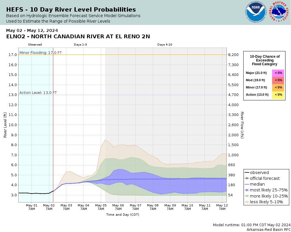
The river remains within its banks in Canadian County... from near El Reno to areas upstream of Yukon. Very low-lying fields and private roads near the river could be briefly isolated by flows in cutoff channels crossing the flood plain. |