Skip Navigation Link weather.gov  
NOAA logo - Click to go to the NOAA homepage National Weather Service NWS logo - Click to go to the NWS homepage
Advanced Hydrologic Prediction Service
Image background of Navigation bar Left
Navigation Bar End Cap


This probabilistic forecast is issued by the Arkansas Red-Basin River Forecast Center.
tab left off Hydrograph tab right off tab left off River at a Glance tab right off tab left off Download tab right off tab left on tab right on
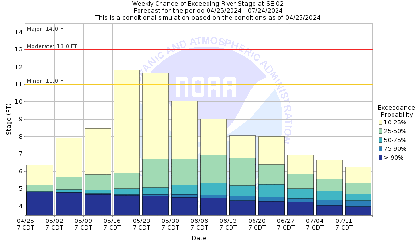
About this graph
Forecasts for the North Canadian River near Seiling are issued as needed during times of high water, but are not routinely available.

Vertical Datum updated from NGVD29 to NAVD88 by gauge owner.

Return to Area Map

Upstream Gauge - near Woodward Upstream Gauge
Zoom Level:16
Flood Categories (in feet)
Major Flood Stage: 14
Moderate Flood Stage: 13
Flood Stage: 11
Action Stage: 9
Low Stage (in feet): -9999

Historic Crests
(1) 16.40 ft on 10/13/1923
(2) 16.00 ft on 10/11/1946
(3) 15.61 ft on 05/19/1951
(4) 14.86 ft on 09/23/1997
(5) 14.28 ft on 08/28/1974
(6) 13.91 ft on 05/08/2019
(7) 13.80 ft on 06/09/1995
(8) 13.71 ft on 05/19/1949
(9) 13.69 ft on 10/10/2018
(10) 13.21 ft on 11/03/1974
Show More Historic Crests

(P): Preliminary values subject to further review.

Recent Crests
(1) 10.97 ft on 06/27/2021
(2) 11.37 ft on 06/05/2019
(3) 13.12 ft on 05/26/2019
(4) 13.03 ft on 05/22/2019
(5) 10.88 ft on 05/14/2019
Show More Recent Crests

(P): Preliminary values subject to further review.

Low Water Records
Currently none available.
KML Image
Gauge LocationGauge Map Marker
Disclaimer
Latitude/Longitude Disclaimer: The gauge location shown in the above map is the approximate location based on the latitude/longitude coordinates provided to the NWS by the gauge owner.
Flood Impacts & Photos Collapse
If you notice any errors in the below information, please contact our Webmaster
17 Croplands... pastures... oil wells... and rural roads are flooded. Areas affected extend from the southwest corner of Major County... downstream to the headwaters of Canton Lake in Dewey County. Cattle and other property should be relocated to places which are at least 6 feet higher than nearby river banks... to avoid being flooded or isolated for several hours by water in side channels.
16 Croplands... pastures... oil wells... and rural roads are flooded. Areas affected extend from the southwest corner of Major County... downstream to the headwaters of Canton Lake in Dewey County. Cattle and other property should be relocated to places which are at least 5 feet higher than nearby river banks... to avoid being flooded or isolated for several hours by water in side channels.
15 Croplands... pastures... oil wells... and rural roads are flooded. Areas affected extend from the southwest corner of Major County... downstream to the headwaters of Canton Lake in Dewey County. Cattle and other property should be relocated to places which are at least 4 feet higher than nearby river banks... to avoid being flooded or isolated for several hours by water in side channels.
14 Croplands... pastures... oil wells... and rural roads are flooded. Areas affected extend from the southwest corner of Major County... downstream to the headwaters of Canton Lake in Dewey County. Cattle and other property should be relocated to places which are at least 3 feet higher than nearby river banks... to avoid being flooded or isolated for several hours by water in side channels.
13 Croplands... pastures... oil wells... and rural roads are flooded. Areas affected extend from the southwest corner of Major County... downstream to the headwaters of Canton Lake in Dewey County. Cattle and other property should be relocated to places which are at least 2 feet higher than nearby river banks... to avoid being isolated for several hours by water in side channels.
12 Croplands... pastures... oil wells... and rural roads are flooded. Areas affected extend from the southwest corner of Major County... downstream to the headwaters of Canton Lake in Dewey County. Cattle and other property should be relocated to places which are at least 1 foot higher than nearby river banks... to avoid being isolated for several hours by water in side channels.
11 Croplands... pastures... oil wells... and rural roads are flooded. Areas affected extend from the southwest corner of Major County... downstream to the headwaters of Canton Lake in Dewey County. Cattle and other property should be relocated to places which are higher than nearby river banks... to avoid being isolated for several hours by water in side channels.
10 Some croplands... pastures... and rural roads may be flooded. Areas affected extend from the southwest corner of Major County... downstream to the headwaters of Canton Lake in Dewey County. Cattle and other property should be relocated to places which are higher than nearby river banks... to avoid being isolated for several hours by water in side channels.

Other Real-time and/or Archive Data Sources:

Collaborative Agencies Collapse
The National Weather Service prepares its forecasts and other services in collaboration with agencies like the US Geological Survey, US Bureau of Reclamation, US Army Corps of Engineers, Natural Resource Conservation Service, National Park Service, ALERT Users Group, Bureau of Indian Affairs, and many state and local emergency managers across the country. For details, please click here.
NWS Information
National Weather Service
Norman Weather Forecast Office
National Weather Center
120 David L. Boren Blvd.
Suite 2400
Norman, OK 73072
(405) 325-3816
Ask Questions/Webmaster
Page last modified: 2-Nov-2020 7:29 PM
Disclaimer
Credits
Glossary
Privacy Policy
About Us
Career Opportunities