Skip Navigation Link weather.gov  
NOAA logo - Click to go to the NOAA homepage National Weather Service NWS logo - Click to go to the NWS homepage
Advanced Hydrologic Prediction Service
Image background of Navigation bar Left
Navigation Bar End Cap


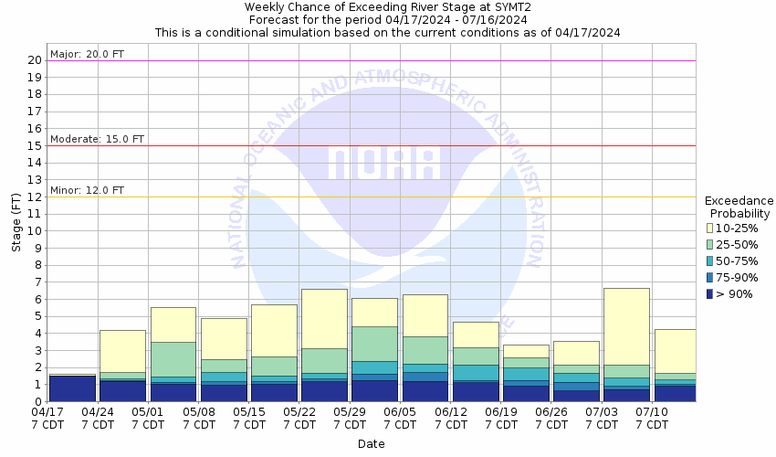
This probabilistic forecast is issued by the West Gulf River Forecast Center.
tab left off Hydrograph tab right off tab left off River at a Glance tab right off tab left off Download tab right off tab left on tab right on
About this graph
Forecasts for the Brazos River at Seymour are issued as needed during times of high water, but are not routinely available.
Return to Area Map

Upstream Gauge - at Aspermont 10S Upstream Gauge Downstream Gauge Downstream Gauge - near South Bend
Zoom Level:16
Flood Categories (in feet)
Major Flood Stage: 20
Moderate Flood Stage: 15
Flood Stage: 12
Action Stage: 10
Low Stage (in feet): -9999

Historic Crests
(1) 23.00 ft on 09/28/1955
(2) 18.98 ft on 10/05/1955
(3) 18.60 ft on 08/17/2005
(4) 18.54 ft on 10/20/1960
(5) 18.35 ft on 08/16/1972
Show More Historic Crests

(P): Preliminary values subject to further review.

Recent Crests
(1) 13.06 ft on 10/07/2018
(2) 12.46 ft on 07/10/2010
(3) 11.83 ft on 10/16/2006
(4) 18.60 ft on 08/17/2005
(5) 14.94 ft on 07/28/2004
Show More Recent Crests

(P): Preliminary values subject to further review.

Low Water Records
Currently none available.
KML Image
Gauge LocationGauge Map Marker
Disclaimer
Latitude/Longitude Disclaimer: The gauge location shown in the above map is the approximate location based on the latitude/longitude coordinates provided to the NWS by the gauge owner.
Flood Impacts & Photos Collapse
If you notice any errors in the below information, please contact our Webmaster
22 Croplands...pastures...and local highways flood across most of the river valley...in southern Knox and southern Baylor counties. Rural areas may have overflow depths up to 10 feet...along with very devastating currents.
21 Croplands...pastures...and local highways flood across most of the river valley...in southern Knox and southern Baylor counties. Rural areas may have overflow depths up to 9 feet...along with very devastating currents.
20 Croplands...pastures...and local highways flood across most of the river valley...in southern Knox and southern Baylor counties. Rural areas may have overflow depths up to 8 feet...along with very devastating currents.
19 Croplands...pastures...and local highways flood across most of the river valley...in southern Knox and southern Baylor counties. Rural areas may have overflow depths up to 7 feet...along with very devastating currents.
18 Croplands...pastures...and local highways flood across most of the river valley...in southern Knox and southern Baylor counties. Rural areas may have overflow depths up to 6 feet...along with very devastating currents.
17 Croplands...pastures...and local roads flood along the river in southern Baylor and southern Knox counties. Rural areas may have overflow depths up to 5 feet...along with very dangerous currents.
16 Flooding affects croplands...pastures...and rural roads along the river in southern Knox and southern Baylor counties. Low-lying areas may experience depths up to 4 feet...with dangerous currents.
15 Flooding affects croplands...pastures...and rural roads along the river in southern Knox and southern Baylor counties. Low-lying areas may experience depths up to 3 feet...with dangerous currents.
14 Short duration flooding affects low-lying areas along and near the river in southern Knox and southern Baylor counties.
13 Short duration flooding affects low-lying areas along and near the river in southern Knox and southern Baylor counties.
12 Shallow and short duration flooding affects low-lying areas along and near the river in southern Knox and southern Baylor counties.
11 Near bankfull stages occur along the river in southern Knox and southern Baylor counties.
10 The river remains within its banks in southern Knox and southern Baylor counties.
Photos
(1) Upstream view of flooding on the Brazos River in late July 2004.
(2) Downstream view of flooding on the Brazos River in late July 2004.
(3) Upstream view of flooding on the Brazos River in mid August 2005.
(4) Downstream view of flooding on the Brazos River in mid August 2005.

Other Real-time and/or Archive Data Sources:

Collaborative Agencies Collapse
The National Weather Service prepares its forecasts and other services in collaboration with agencies like the US Geological Survey, US Bureau of Reclamation, US Army Corps of Engineers, Natural Resource Conservation Service, National Park Service, ALERT Users Group, Bureau of Indian Affairs, and many state and local emergency managers across the country. For details, please click here.
NWS Information
National Weather Service
Norman Weather Forecast Office
National Weather Center
120 David L. Boren Blvd.
Suite 2400
Norman, OK 73072
(405) 325-3816
Ask Questions/Webmaster
Page last modified: 2-Nov-2020 7:29 PM
Disclaimer
Credits
Glossary
Privacy Policy
About Us
Career Opportunities