Skip Navigation Link weather.gov  
NOAA logo - Click to go to the NOAA homepage National Weather Service NWS logo - Click to go to the NWS homepage
Advanced Hydrologic Prediction Service
Image background of Navigation bar Left
Navigation Bar End Cap


This probabilistic forecast is issued by the Ohio River Forecast Center.
tab left off Hydrograph tab right off tab left off River at a Glance tab right off tab left off Download tab right off tab left on tab right on
About this graph
Forecasts for the Monongahela River at Grays Landing Lock and Dam are issued routinely year-round.
Return to Area Map

Upstream Locations Upstream Gauge Downstream Gauge Downstream Gauge - at Maxwell Lock and Dam (lower pool)
Zoom Level:16
Flood Categories (in feet)
Major Flood Stage: 27
Moderate Flood Stage: 25
Flood Stage: 21
Action Stage: 15
Low Stage (in feet): -9999

Historic Crests
(1) 36.00 ft on 07/01/1888
(2) 30.50 ft on 11/05/1985
(3) 28.40 ft on 03/18/1936
(4) 25.80 ft on 01/20/1996
(5) 24.50 ft on 02/19/2000
(6) 23.95 ft on 07/29/2017
(7) 22.78 ft on 03/04/2015
(8) 22.07 ft on 02/17/2018
(9) 21.77 ft on 03/01/2021 (P)
(10) 21.70 ft on 12/14/2007
Show More Historic Crests

(P): Preliminary values subject to further review.

Recent Crests
(1) 21.77 ft on 03/01/2021 (P)
(2) 16.40 ft on 07/01/2019
(3) 15.88 ft on 02/13/2019
(4) 16.85 ft on 02/08/2019
(5) 17.06 ft on 01/20/2019
(6) 18.80 ft on 09/28/2018
(7) 18.05 ft on 09/10/2018
(8) 22.07 ft on 02/17/2018
(9) 18.70 ft on 01/13/2018
(10) 23.95 ft on 07/29/2017
Show More Recent Crests

(P): Preliminary values subject to further review.

Low Water Records
Currently none available.
KML Image
Gauge LocationGauge Map Marker
Disclaimer
Latitude/Longitude Disclaimer: The gauge location shown in the above map is the approximate location based on the latitude/longitude coordinates provided to the NWS by the gauge owner.
Flood Impacts & Photos Collapse
If you notice any errors in the below information, please contact our Webmaster
36 Water reaches the flood of record...July 1, 1888.
35 Flood waters reach the historic log cabin along Front Street in Greensboro.
34 Flood waters reach the corner of Front and County Streets in Greensboro.
31 Flood waters reach the Bed and Breakfast on County Street in Greensboro.
30.5 Water reaches level of the November 5, 1985 flood.
28.4 Water reaches the level of the St. Patricks Day Flood and crest on March 18, 1936.
25.8 Water reaches the level reached during the rain and snowmelt flood on January 20, 1996.
25 Flood waters reach Martin Ferry Road in the village of Glasworks.
24 The lock walls are overtopped at Grays Landing Lock and Dam.
23.95 Water levels reach the flood levels of the flood of July 29, 2017.
22.78 Water reaches the level reached on March 4, 2015.
21 The lock at Grays Landing Lock and Dam goes out of service, and navigation is suspended.
19 The bike trail floods in Greensboro near County Street.

Other Real-time and/or Archive Data Sources:

Additional Information Collapse
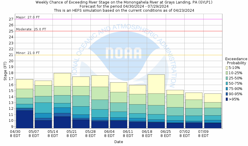
Potential River Levels - Used to
Potential River Levels
Used to Estimate the Chance of Flooding and the Range of Possible River Levels
10 Day (HEFS) 10 Day (NAEFS) 10 Day (GEFS)
HEFS Ensemble NAEFS Ensemble GEFS Ensemble

Note: Use the official hydrograph at the top of this web page for river levels within the next 72 hours.

USGS Hydrograph/Discharge Last 7 days
USGS Hydrograph/Discharge Last 30 days
USGS Flood Tracking Chart Builder
USGS Rating Curve
USGS Gage Information
Collaborative Agencies Collapse
The National Weather Service prepares its forecasts and other services in collaboration with agencies like the US Geological Survey, US Bureau of Reclamation, US Army Corps of Engineers, Natural Resource Conservation Service, National Park Service, ALERT Users Group, Bureau of Indian Affairs, and many state and local emergency managers across the country. For details, please click here.
NWS Information
National Weather Service
Pittsburgh Weather Forecast Office
192 Shafer Road
Moon Township, PA 15108
(412) 262-1591
Ask Questions/Webmaster
Page last modified: 2-Nov-2020 7:30 PM
Disclaimer
Credits
Glossary
Privacy Policy
About Us
Career Opportunities