Skip Navigation Link weather.gov  
NOAA logo - Click to go to the NOAA homepage National Weather Service NWS logo - Click to go to the NWS homepage
Advanced Hydrologic Prediction Service
Image background of Navigation bar Left
Navigation Bar End Cap


This probabilistic forecast is issued by the Middle Atlantic River Forecast Center.
tab left off Hydrograph tab right off tab left off River at a Glance tab right off tab left off Download tab right off tab left off Inundation
Mapping
tab right off tab left on tab right on
About this graph
Forecasts for the Delaware River at Trenton are issued routinely year-round.
Return to Area Map

Upstream Gauge - at Washington Crossing Upstream Gauge
Zoom Level:16
Flood Categories (in feet)
Major Flood Stage: 25
Moderate Flood Stage: 23
Flood Stage: 20
Action Stage: 17
Low Stage (in feet): 0

Historic Crests
(1) 30.60 ft on 03/08/1904
(2) 28.60 ft on 08/20/1955
(3) 28.50 ft on 10/11/1903
(4) 25.33 ft on 04/04/2005
(5) 25.09 ft on 06/29/2006
Show More Historic Crests

(P): Preliminary values subject to further review.

Recent Crests
(1) 20.76 ft on 09/03/2021
(2) 19.93 ft on 01/15/2018 (P)
(3) 16.46 ft on 05/01/2014
(4) 20.76 ft on 01/09/2014
(5) 22.16 ft on 09/09/2011
Show More Recent Crests

(P): Preliminary values subject to further review.

Low Water Records
Currently none available.
KML Image
Gauge LocationGauge Map Marker
Disclaimer
Latitude/Longitude Disclaimer: The gauge location shown in the above map is the approximate location based on the latitude/longitude coordinates provided to the NWS by the gauge owner.
Flood Impacts & Photos Collapse
If you notice any errors in the below information, please contact our Webmaster
25 The Delaware River meets the Delaware Canal, backfilling the Rivermawr and Flats neighborhoods making all roads east of the canal impassable.
24.5 Carr's Lane in Yardley begins to flood.
23 North and South Bell Avenues in Yardley begin to flood.
22 Route 32 in Yardley is flooded in both directions. Up to two feet of water covers portions of Morgan Avenue, Brown Street, Maple Avenue, and Fuld Avenue.
21.5 Ferry Street in Yardley begins to flood.
20 Houses on Brown Street in Yardley begin to take on water. Houses on Afton Avenue also take on water. Southbound lanes are closed along stretches of Route 29 in Trenton. Route 32 North is closed in Yardley borough. River Road (Route 32), north of Woodside Road and south of Mt. Eyre Road, in Lower Makefield Township, begins to flood.
19.5 Morgan Avenue in Yardley Borough begins to flood. River Road (PA Rt 32) at East Ferry Road in Lower Makefield Township begins to flood.
18.5 Route 32 South at East College Avenue in Yardley borough begins to flood.
18 Route 32 North is closed between Brown Street and Maple Avenue.
17 Pa Route 32 North in Yardley Borough begins to flood between Brown Street and Maple Avenue.
Photos
(1) Ice at the Trenton Gage

Other Real-time and/or Archive Data Sources:

Additional Information Collapse
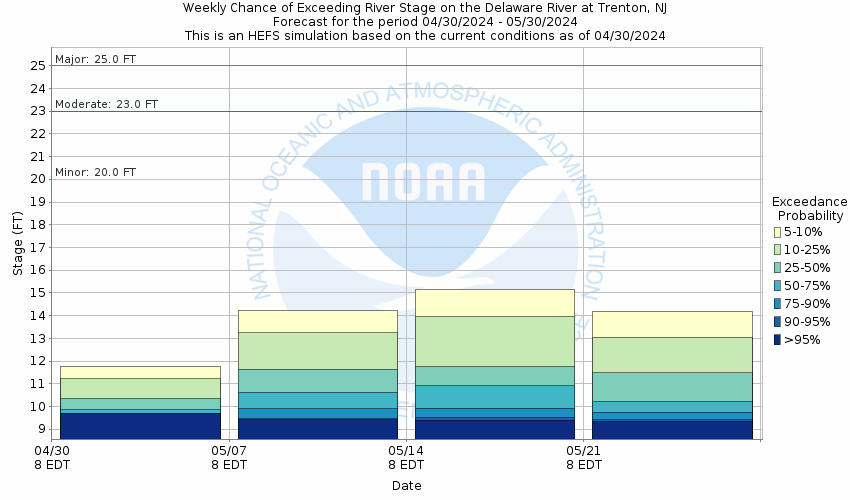
Potential River Levels - Used to
Potential River Levels
Used to Estimate the Chance of Flooding and the Range of Possible River Levels
10 Day (HEFS) 10 Day (NAEFS) 10 Day (GEFS)
HEFS Ensemble NAEFS Ensemble GEFS Ensemble

Note: Use the official hydrograph at the top of this web page for river levels within the next 72 hours.

Click individual graphics to enlarge.

During winter months, cold and ice may result in inaccurate real-time stream stage and streamflow data. Adjustments or deletions of this data can only be done after detailed analysis.
Collaborative Agencies Collapse
The National Weather Service prepares its forecasts and other services in collaboration with agencies like the US Geological Survey, US Bureau of Reclamation, US Army Corps of Engineers, Natural Resource Conservation Service, National Park Service, ALERT Users Group, Bureau of Indian Affairs, and many state and local emergency managers across the country. For details, please click here.
NWS Information
National Weather Service
Philadelphia/Mount Holly Weather Forecast Office
732 Woodlane Road
Mount Holly, NJ 08060-9615
(609) 261-6600
Ask Questions/Webmaster
Page last modified: 2-Nov-2020 7:30 PM
Disclaimer
Credits
Glossary
Privacy Policy
About Us
Career Opportunities