Historic Crests
(1) 17.50 ft on 10/10/1903
(2) 14.19 ft on 08/30/2011
(3) 12.91 ft on 04/07/1984
(4) 11.88 ft on 04/18/2007
(5) 11.87 ft on 03/16/2010 Show More Historic Crests
(P): Preliminary values subject to further review.
Recent Crests
(1) 8.56 ft on 01/15/2024
(2) 7.47 ft on 12/30/2023
(3) 10.29 ft on 12/20/2023
(4) 7.44 ft on 04/10/2022
(5) 9.30 ft on 09/04/2021 Show More Recent Crests
(P): Preliminary values subject to further review.
Latitude/Longitude Disclaimer: The gauge location shown in the above map
is the approximate location based on the latitude/longitude coordinates
provided to the NWS by the gauge owner.
Flood Impacts & Photos
If you notice any errors in the below information, please contact our Webmaster
12
Wagaraw Road in Hawthorne, between Lafayette Avenue and Lincoln Avenue, is closed. Passaic Avenue, Schoon Avenue and Vincent Street are also closed. Homes and businesses flood.
11.5
Tyler Street, Shady Street, Arch Street, Lowe Street, Wood Street, and Bleeker Street in Paterson are closed due to flooding.
11
The West Broadway Bridge in Paterson is subject to closures.
10.5
Businesses along Route 46 in Wayne begin to flood. Route 23 floods. The Willowbrook Mall experiences flooding. Haledon Avenue bridge in Paterson is subject to closures. Also in Paterson, portions of Straight Street, Union Avenue, West Broadway, Ryle Avenue, East Main Street, North Main Street, and Haledon Avenue are also subject to closures due to flooding.
10
Wagaraw Road in Hawthorne is closed. Homes and businesses in Hawthorne, directly along the river, begin to flood. Water begins to flow over the Temple Street bridge in Paterson.
9.5
Route 46 in Wayne is subject to closures. Riverside Drive in Wayne floods. Flooding in Little Falls worsens as homes on William Street and Zeliff Avenue take on water. Arch Street and Temple Street bridges in Paterson are subject to closures. Also in Paterson, portions of Watson Street, Hillman Street, Bergen Street, east Holsman Street, North 1st Street, Fifth Avenue, Sixth Avenue, and Goodwin Street are also subject to closures due to flooding.
9
Widespread flooding occurs throughout Lincoln Park and Wayne with many evacuations. In Paterson, portions of River Street, Presidential Boulevard, Bridge Street, Tyler Street, Totowa Avenue and Mclean Boulevard are flooded.
8.5
Widespread flooding occurs in Fairfield.
8
Flooding occurs in the "Old" Wayne area of Wayne. The recycling center and Wagaraw Road ball field complex in Hawthorne begins to experience flooding.
7
Minor flooding begins in Lincoln Park, Wayne and Little Falls.
6.5
Low lying areas in the vicinity of Two Bridges in Wayne are flooded. The lower end of Bergen Street in Paterson, closest to the river, begins to flood.
6
Portions of Hoffman Grove in Wayne sustain some nuisance flooding.
5.5
The lower end of East-Holsman Street in Paterson, closest to the river, begins to flood.
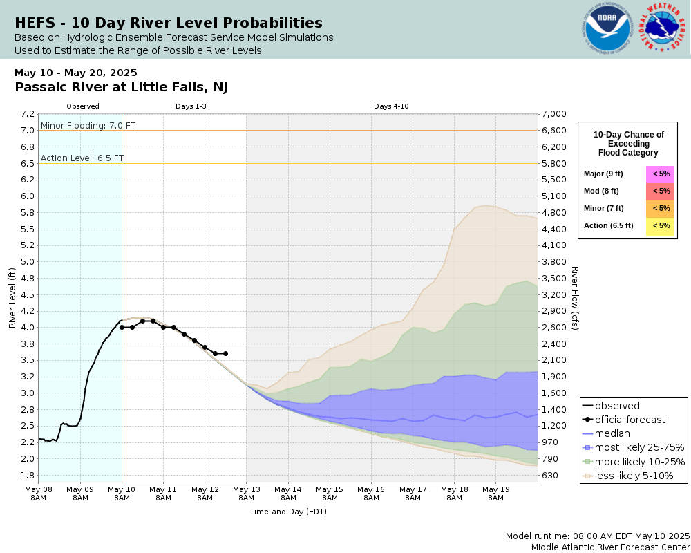
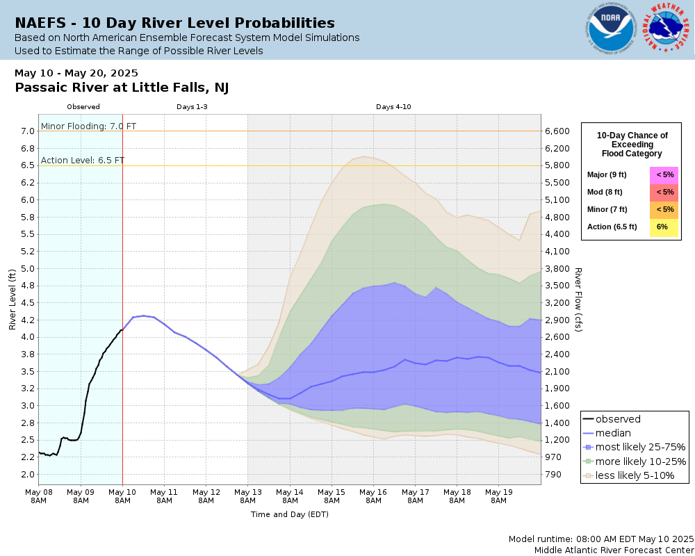
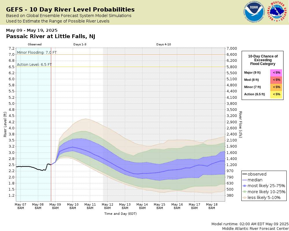
Potential River Levels Used to Estimate the Chance of Flooding and
the Range of Possible River Levels
10 Day (HEFS)
10 Day (NAEFS)
10 Day (GEFS)
Note: Use the official hydrograph at the top of this web page
for river levels within the next 72 hours.
Click individual graphics to
enlarge.
During winter months, cold and ice may result in inaccurate real-time stream stage and streamflow data. Adjustments or deletions of this data can only be done after detailed analysis.
Collaborative Agencies
The National Weather Service prepares its forecasts and other services in collaboration with agencies like the US Geological Survey, US Bureau of Reclamation, US Army Corps of Engineers, Natural Resource Conservation Service, National Park Service, ALERT Users Group, Bureau of Indian Affairs, and many state and local emergency managers across the country. For details, please click here.
NWS Information
National Weather Service
Philadelphia/Mount Holly Weather Forecast Office
732 Woodlane Road
Mount Holly, NJ 08060-9615
(609) 261-6600 Ask Questions/Webmaster
Page last modified: 2-Nov-2020 7:30 PM