Skip Navigation Link weather.gov  
NOAA logo - Click to go to the NOAA homepage National Weather Service NWS logo - Click to go to the NWS homepage
Advanced Hydrologic Prediction Service
Image background of Navigation bar Left
Navigation Bar End Cap


This probabilistic forecast is issued by the Southeast River Forecast Center.
tab left off Hydrograph tab right off tab left off River at a Glance tab right off tab left off Download tab right off tab left on tab right on
About this graph
Forecasts for the Cape Fear River at Fayetteville are issued routinely year-round.
Return to Area Map

Upstream Locations Upstream Gauge Downstream Gauge Downstream Gauge - at W.O. Huske Lock
Zoom Level:14
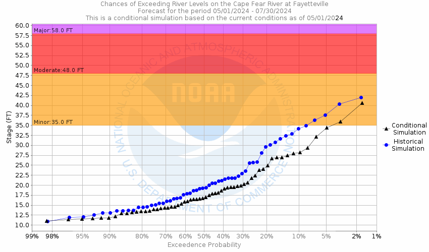
Flood Categories (in feet)
Major Flood Stage: 58
Moderate Flood Stage: 48
Flood Stage: 35
Action Stage: 35
Low Stage (in feet): -9999

Historic Crests
(1) 68.90 ft on 09/21/1945
(2) 68.00 ft on 08/29/1908
(3) 65.30 ft on 10/04/1929
(4) 64.70 ft on 09/22/1928
(5) 61.58 ft on 09/19/2018
Show More Historic Crests

(P): Preliminary values subject to further review.

Recent Crests
(1) 35.32 ft on 02/17/2021 (P)
(2) 36.05 ft on 01/04/2021 (P)
(3) 41.68 ft on 02/08/2020
(4) 43.49 ft on 11/16/2018
(5) 24.60 ft on 10/13/2018
Show More Recent Crests

(P): Preliminary values subject to further review.

Low Water Records
(1) 8.50 ft on 10/22/1940
(2) 8.70 ft on 10/14/1941
(3) 8.70 ft on 10/15/1943
KML Image
Gauge LocationGauge Map Marker
Disclaimer
Latitude/Longitude Disclaimer: The gauge location shown in the above map is the approximate location based on the latitude/longitude coordinates provided to the NWS by the gauge owner.
Flood Impacts & Photos Collapse
If you notice any errors in the below information, please contact our Webmaster
72 The river will spread to a width of up to 2 miles, with several thousand structures threatened.
69 The city of Fayetteville begins to flood and up to one hundred and fifty homes would be threatened. At this stage the river widens to a mile or more in some places.
64 Several thousand acres of land and hundreds of structures on both sides of the river will be flooded. Water reaches the under-clearance of the downstream railroad trestle. Downstream about 2 miles, the river will spread to a width of approximately 1 mile.
60 Water begins to bypass the left end of the NC24 bridge for several hundred yards. Two miles downstream, the left bank widens to 1000 feet and to a depth of several feet. Cumberland Tractor lot begins to flood.
59 The river will reach the bottom of the railroad bridge just downstream of the Person Street bridge. Debris will get stuck against the railroad bridge.
58 Major flooding begins. The right bank widens to several hundred feet and there is significant flooding of downstream structures.
50 There is significant overflow on the left bank about 2 miles downstream of the NC24 bridge.
48 Moderate flooding begins. The upper parking areas at Riverside Bait and Tackle are flooded. There is significant lowland flooding downstream.
35 Minor flooding begins. The boat ramp and lower parking lot at Riverside Bait and Tackle off Person Street are flooded. The stage and lower seating area at the Cape Fear amphitheater are flooded.
32 Action Stage. Banks of the Cape Fear River begin to overflow.
Photos
(1) Downstream
(2) Upstream

Other Real-time and/or Archive Data Sources:

Additional Information Collapse
Potential River Levels - Used to
Potential River Levels
Used to Estimate the Chance of Flooding and the Range of Possible River Levels
10 day (HEFS) 7 Day (NAEFS) 7 Day (GEFS)
HEFS Ensemble NAEFS Ensemble GEFS Ensemble

Note: Use the official hydrograph at the top of this web page for river levels within the next 72 Hours.


Collaborative Agencies Collapse
The National Weather Service prepares its forecasts and other services in collaboration with agencies like the US Geological Survey, US Bureau of Reclamation, US Army Corps of Engineers, Natural Resource Conservation Service, National Park Service, ALERT Users Group, Bureau of Indian Affairs, and many state and local emergency managers across the country. For details, please click here.
NWS Information
National Weather Service
Raleigh Weather Forecast Office
1005 Capability Drive, Suite 300
Raleigh, NC 27606
(919) 326-1042
Ask Questions/Webmaster
Page last modified: 2-Nov-2020 7:30 PM
Disclaimer
Credits
Glossary
Privacy Policy
About Us
Career Opportunities