Skip Navigation Link weather.gov  
NOAA logo - Click to go to the NOAA homepage National Weather Service NWS logo - Click to go to the NWS homepage
Advanced Hydrologic Prediction Service
Image background of Navigation bar Left
Navigation Bar End Cap


This probabilistic forecast is issued by the Lower Mississippi River Forecast Center.
tab left off Hydrograph tab right off tab left off River at a Glance tab right off tab left off Download tab right off tab left on tab right on
About this graph
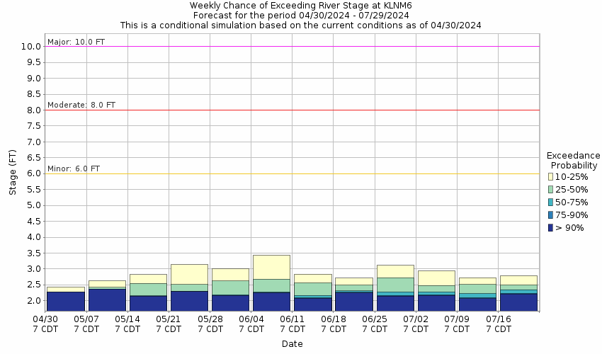
Forecasts for the Jourdan River at Kiln are issued routinely year-round.
Return to Area Map

Zoom Level:16
Flood Categories (in feet)
Major Flood Stage: 10
Moderate Flood Stage: 8
Flood Stage: 6
Action Stage: 5
Low Stage (in feet): -9999

Historic Crests
(1) 19.97 ft on 08/29/2005
(2) 12.55 ft on 05/10/1995
(3) 10.73 ft on 08/29/2012
(4) 9.83 ft on 09/01/2008
(5) 9.46 ft on 08/31/2021
Show More Historic Crests

(P): Preliminary values subject to further review.

Recent Crests
(1) 9.46 ft on 08/31/2021
(2) 6.89 ft on 06/20/2021
(3) 6.31 ft on 04/16/2021
(4) 7.76 ft on 10/28/2020 (P)
(5) 7.61 ft on 06/07/2020 (P)
Show More Recent Crests

(P): Preliminary values subject to further review.

Low Water Records
(1) -3.02 ft on 01/02/2008
(2) -2.69 ft on 03/02/2009
(3) -2.52 ft on 12/13/2010
(4) -2.47 ft on 01/12/2012
(5) -2.36 ft on 01/20/2019
Show More Low Water Records
KML Image
Gauge LocationGauge Map Marker
Disclaimer
Latitude/Longitude Disclaimer: The gauge location shown in the above map is the approximate location based on the latitude/longitude coordinates provided to the NWS by the gauge owner.
Flood Impacts & Photos Collapse
If you notice any errors in the below information, please contact our Webmaster
19.97 Flood of Record occurred on August 29,2005 in Hurricane Katrina. Devastating flooding will occur over the area. Most roadways will be inundated, including Interstate 10, along with MS Highways 43 and 603. Evacuations will be necessary.
12 Major flooding will occur downstream of Highway 43. The highway will be closed with deep swift water over the roadway north of the bridge.
10 Homes along the river on the south bank will flood. Water will be over the road near the bridge approach. Backwater flooding will threaten property east of Highway 43. Access to the river will be restricted.
8 The River Dock Restraunt will flood. Drainage ditches along Mississippi Highway 43 will be running full and near the shoulder of the road at the bridge approach. Water will cover most of the River Dock property and residential property on the south bank.
6 Water will cover most of the River Dock Resturant property and residential property on the south bank.
5 The boat dock at the River Dock Restaurant will be under water and property along both north and south banks will begin to flood.

Other Real-time and/or Archive Data Sources:

Collaborative Agencies Collapse
The National Weather Service prepares its forecasts and other services in collaboration with agencies like the US Geological Survey, US Bureau of Reclamation, US Army Corps of Engineers, Natural Resource Conservation Service, National Park Service, ALERT Users Group, Bureau of Indian Affairs, and many state and local emergency managers across the country. For details, please click here.
NWS Information
National Weather Service
Reno Weather Forecast Office
2350 Raggio Pkwy
Reno, NV 89512-3900
(775) 673-8100
Ask Questions/Webmaster
Page last modified: 2-Nov-2020 7:27 PM
Disclaimer
Credits
Glossary
Privacy Policy
About Us
Career Opportunities