Skip Navigation Link weather.gov  
NOAA logo - Click to go to the NOAA homepage National Weather Service NWS logo - Click to go to the NWS homepage
Advanced Hydrologic Prediction Service
Image background of Navigation bar Left
Navigation Bar End Cap


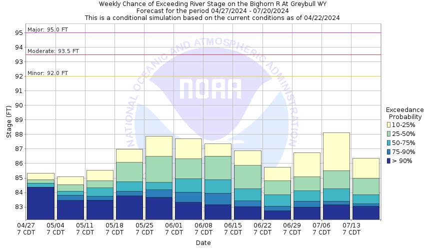
This probabilistic forecast is issued by the Missouri Basin River Forecast Center.
tab left off Hydrograph tab right off tab left off River at a Glance tab right off tab left off Download tab right off tab left on tab right on
About this graph
Forecasts for the Bighorn River at Greybull are issued as needed during times of high water, but are not routinely available.
Return to Area Map

Upstream Gauge - at Basin Upstream Gauge
Zoom Level:12
Flood Categories (in feet)
Major Flood Stage: 95
Moderate Flood Stage: 93.5
Flood Stage: 92
Action Stage: 90
Low Stage (in feet): -9999

Historic Crests
(1) 93.50 ft on 03/09/2014
(2) 91.90 ft on 02/22/2017
(3) 91.10 ft on 06/08/1991
(4) 90.50 ft on 06/11/2011
Show More Historic Crests

(P): Preliminary values subject to further review.

Recent Crests
(1) 87.65 ft on 06/02/2018
(2) 89.06 ft on 03/10/2018
(3) 91.90 ft on 02/22/2017
(4) 93.50 ft on 03/09/2014
Show More Recent Crests

(P): Preliminary values subject to further review.

Low Water Records
Currently none available.
KML Image
Gauge LocationGauge Map Marker
Disclaimer
Latitude/Longitude Disclaimer: The gauge location shown in the above map is the approximate location based on the latitude/longitude coordinates provided to the NWS by the gauge owner.
Flood Impacts & Photos Collapse
If you notice any errors in the below information, please contact our Webmaster
95 Levee around Greybull will be overtopped causing widespread flooding.
92 Flood stage. Low lying flooding intensifies and becomes more widespread along southern areas of Greybull. Levee may be in danger of failing in many area with prolonged high flows. Corresponds to "7" reference point measured at staff gage under Highway 14 Bridge.
91.1 Record high stage (6/8/1991). Estimated flow: 20,000 - 22,000 cfs.
91 Water may begin to surge over low spots along the levee near the southern end of Greybull. Flooding expected along areas behind levee near southern areas of Greybull. Water will begin to surge against the rest of the levee throughout the town. Corresponds to "6" reference point measured at staff gage under Highway 14 Bridge.
90 Bankfull stage. Constant monitoring of levee is needed. Water begins to surge against base of levee near the south end of Greybull. Corresponds to "d" reference point measured at base of dike under Highway 14 Bridge.
80 Baseflow stage of the river (3880' elevation above sea level).
Photos
(1) Looking Upstream---High flows due to ice jam---late February 2017
(2) Looking Downstream---High flows due to ice jam---late February 2017
(3) Looking Upstream---Moderate Flow
(4) Looking Downstream---Moderate Flow
Collaborative Agencies Collapse
The National Weather Service prepares its forecasts and other services in collaboration with agencies like the US Geological Survey, US Bureau of Reclamation, US Army Corps of Engineers, Natural Resource Conservation Service, National Park Service, ALERT Users Group, Bureau of Indian Affairs, and many state and local emergency managers across the country. For details, please click here.
NWS Information
National Weather Service
Riverton Weather Forecast Office
12744 West U.S. Highway 26
Riverton, WY 82501
(307) 857-3898
Ask Questions/Webmaster
Page last modified: 2-Nov-2020 7:28 PM
Disclaimer
Credits
Glossary
Privacy Policy
About Us
Career Opportunities