Skip Navigation Link weather.gov  
NOAA logo - Click to go to the NOAA homepage National Weather Service NWS logo - Click to go to the NWS homepage
Advanced Hydrologic Prediction Service
Image background of Navigation bar Left
Navigation Bar End Cap


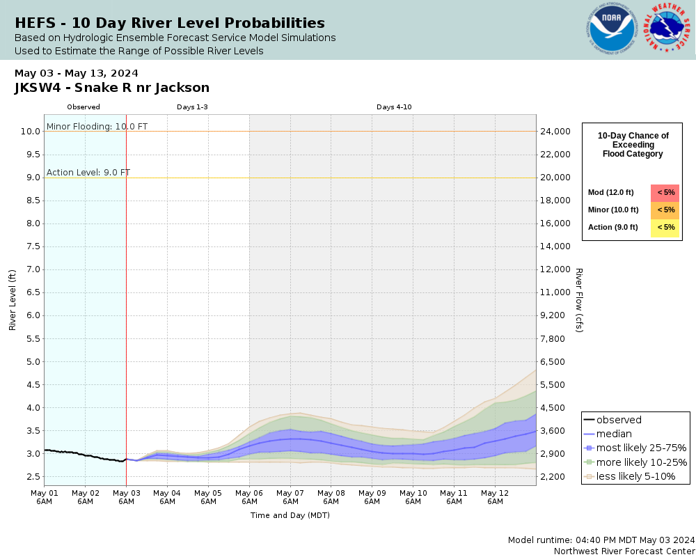
This probabilistic forecast is issued by the Northwest River Forecast Center.
tab left off Hydrograph tab right off tab left off River at a Glance tab right off tab left off Download tab right off tab left on tab right on
Experimental Short Range Forecast Uncertainty (AHPS) - External Links: Product Description Document | Customer Survey
About this graph
Forecasts for the Snake River near Jackson are issued routinely year-round.
Return to Area Map

Downstream Gauge Downstream Gauge - near Alpine
Zoom Level:14
Flood Categories (in feet)
Major Flood Stage: 0
Moderate Flood Stage: 12
Flood Stage: 10
Action Stage: 9
Low Stage (in feet): -9999

Historic Crests
(1) 11.66 ft on 06/11/1997
(2) 10.22 ft on 06/06/1986
(3) 10.12 ft on 06/11/1996
(4) 10.00 ft on 06/06/2017
(5) 9.25 ft on 06/29/1982
Show More Historic Crests

(P): Preliminary values subject to further review.

Recent Crests
(1) 6.40 ft on 06/06/2021
(2) 8.05 ft on 06/07/2020
(3) 6.54 ft on 05/17/2019
(4) 8.97 ft on 06/01/2018
(5) 10.00 ft on 06/06/2017
Show More Recent Crests

(P): Preliminary values subject to further review.

Low Water Records
Currently none available.
KML Image
Gauge LocationGauge Map Marker
Disclaimer
Latitude/Longitude Disclaimer: The gauge location shown in the above map is the approximate location based on the latitude/longitude coordinates provided to the NWS by the gauge owner.
Flood Impacts & Photos Collapse
If you notice any errors in the below information, please contact our Webmaster
11.66 Record stage and flow---30,200 cfs (6/11/1997).
11.1 Flows in excess of 30,000 cfs can cause substantial erosional damage to the levee system. Levee repair begins to overwhelm available resources. Extended periods of flow at this level seriously threatens low-lying property in the Snake River flood plain below Jackson Lake.
10.8 Minor damage and/or problems to levee structures between Jackson Lake and the gage site begin. 24-hour monitoring of levees is needed.
10.5 Snake River begins to cause flooding near the Bridger-Teton National Forest Cottonwood Work Center. Cabins and garages begin to flood and escape routes start to be cut off.
10 Flood stage. Minor low land flooding.
Photos
(1) Looking Upstream---Moderate Flow
(2) Looking Downstream---Moderate Flow
(3) Looking Upstream---Low Flow
(4) Looking Downstream---Low Flow

Other Real-time and/or Archive Data Sources:

Collaborative Agencies Collapse
The National Weather Service prepares its forecasts and other services in collaboration with agencies like the US Geological Survey, US Bureau of Reclamation, US Army Corps of Engineers, Natural Resource Conservation Service, National Park Service, ALERT Users Group, Bureau of Indian Affairs, and many state and local emergency managers across the country. For details, please click here.
NWS Information
National Weather Service
Riverton Weather Forecast Office
12744 West U.S. Highway 26
Riverton, WY 82501
(307) 857-3898
Ask Questions/Webmaster
Page last modified: 2-Nov-2020 7:28 PM
Disclaimer
Credits
Glossary
Privacy Policy
About Us
Career Opportunities