Skip Navigation Link weather.gov  
NOAA logo - Click to go to the NOAA homepage National Weather Service NWS logo - Click to go to the NWS homepage
Advanced Hydrologic Prediction Service
Image background of Navigation bar Left
Navigation Bar End Cap


This probabilistic forecast is issued by the California Nevada River Forecast Center.
tab left off Hydrograph tab right off tab left off River at a Glance tab right off tab left off Download tab right off tab left on tab right on
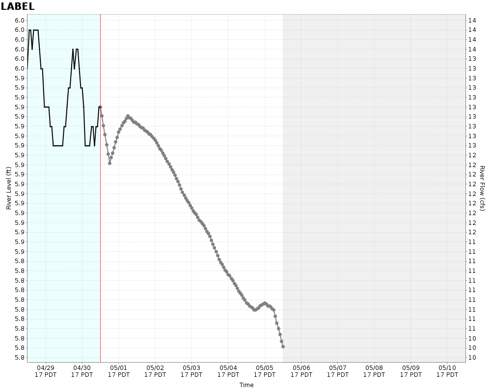
Experimental Short Range Forecast Uncertainty (AHPS) - External Links: Product Description Document | Customer Survey
About this graph
Forecasts for the Mojave River near Victorville are issued routinely year-round.
Return to Area Map

Zoom Level:16
Flood Categories (in feet)
Major Flood Stage: 19
Moderate Flood Stage: 18
Flood Stage: 16
Action Stage: 0
Low Stage (in feet): -9999

Historic Crests
(1) 33.70 ft on 03/02/1938
(2) 21.45 ft on 03/01/1983
(3) 19.25 ft on 02/24/1998
(4) 18.06 ft on 02/16/1980
(5) 17.72 ft on 12/21/2010 (P)
Show More Historic Crests

(P): Preliminary values subject to further review.

Recent Crests
(1) 17.45 ft on 02/15/2019
(2) 13.20 ft on 01/23/2017
(3) 17.72 ft on 12/21/2010 (P)
(4) 14.55 ft on 01/11/2005
(5) 19.25 ft on 02/24/1998
Show More Recent Crests

(P): Preliminary values subject to further review.

Low Water Records
(1) 9.94 ft on 12/14/2005
KML Image
Gauge LocationGauge Map Marker
Disclaimer
Latitude/Longitude Disclaimer: The gauge location shown in the above map is the approximate location based on the latitude/longitude coordinates provided to the NWS by the gauge owner.
Flood Impacts & Photos Collapse
If you notice any errors in the below information, please contact our Webmaster
19 Significant flows are occurring along the entire reach of the river, with flooding of adjacent farm lands north of victorville. The levees are threatened in the more densely populated areas of hesperia, victorville, and helendale, with overtopping possible in areas where vegetation or debris chokes the channel.
18 Significant flows have likely reached helendale and points to the north, with farm lands in the river bed and adjacent areas north of victorville inundated. Rock springs road in hesperia is in danger of washing out. Some erosion of the levees can be expected in victorville and helendale.
16 Significant flows reach farming areas north of victorville. Minor flooding of farmland adjacent to the river bed can be expected in oro grande. Some local erosion to the levees in hesperia and victorville is possible. Rock springs road has been overtopped and closed to traffic in hesperia.
13 AS WATER BEGINS TO FLOW IN THE NORMALLY DRY RIVERBED. LOW-WATER CROSSINGS WELL UPSTREAM OF THIS GAGE SUCH AS ROCK SPRINGS ROAD BELOW THE MOJAVE FORKS DAM MAY BE OVERTOPPED AND CLOSED. THIS CORRESPONDS WITH A POOL LEVEL OF 3005 FT AND ABOUT 2500 CFS. RELEASES FROM SILVERWOOD LAKE CAN ADD A CONSIDERABLE AMOUNT OF INFLOW BEHIND THE DAM.

Other Real-time and/or Archive Data Sources:

Additional Information Collapse
Use data with caution. The graphical flow-stage relationship may not be accurate due to significant scour, resulting from high flows in late 2010. The United States Geological Survey will be updating the flow-stage relationship when additional river measurements can be obtained.
Collaborative Agencies Collapse
The National Weather Service prepares its forecasts and other services in collaboration with agencies like the US Geological Survey, US Bureau of Reclamation, US Army Corps of Engineers, Natural Resource Conservation Service, National Park Service, ALERT Users Group, Bureau of Indian Affairs, and many state and local emergency managers across the country. For details, please click here.
NWS Information
National Weather Service
San Diego Weather Forecast Office
11440 W. Bernardo Court, Suite 230
San Diego, CA 92127
(858) 675-8700
Ask Questions/Webmaster
Page last modified: 2-Nov-2020 7:27 PM
Disclaimer
Credits
Glossary
Privacy Policy
About Us
Career Opportunities