Skip Navigation Link weather.gov  
NOAA logo - Click to go to the NOAA homepage National Weather Service NWS logo - Click to go to the NWS homepage
Advanced Hydrologic Prediction Service
Image background of Navigation bar Left
Navigation Bar End Cap


This probabilistic forecast is issued by the West Gulf River Forecast Center.
tab left off Hydrograph tab right off tab left off River at a Glance tab right off tab left off Download tab right off tab left off Inundation
Mapping
tab right off tab left on tab right on
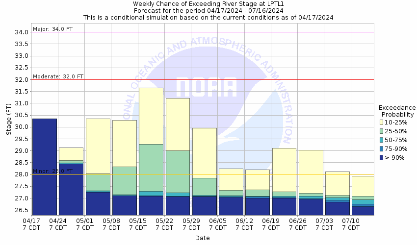
About this graph
Forecasts for the Sabine River at Logansport are issued as needed during times of high water, but are not routinely available.
Return to Area Map

Upstream Locations Upstream Gauge Downstream Gauge Downstream Locations
Zoom Level:14
Flood Categories (in feet)
Major Flood Stage: 34
Moderate Flood Stage: 32
Flood Stage: 28
Action Stage: 27
Low Stage (in feet): 0

Historic Crests
(1) 44.07 ft on 04/08/1945
(2) 39.41 ft on 05/07/1957
(3) 39.40 ft on 05/01/1984
(4) 38.46 ft on 05/06/1966
(5) 37.82 ft on 05/10/1958
Show More Historic Crests

(P): Preliminary values subject to further review.

Recent Crests
(1) 31.61 ft on 05/13/2019
(2) 30.86 ft on 05/04/2016
(3) 35.06 ft on 03/13/2016
(4) 32.24 ft on 01/10/2016
(5) 29.32 ft on 05/19/2015
Show More Recent Crests

(P): Preliminary values subject to further review.

Low Water Records
(1) 16.85 ft on 11/09/1987
KML Image
Gauge LocationGauge Map Marker
Disclaimer
Latitude/Longitude Disclaimer: The gauge location shown in the above map is the approximate location based on the latitude/longitude coordinates provided to the NWS by the gauge owner.
Flood Impacts & Photos Collapse
If you notice any errors in the below information, please contact our Webmaster
35 The Logansport municipal water plant will be in danger of flooding. Several dozens of homes will be flooded as well from Joaqun, Texas through the Logansport area. Preparations for major flooding should be rushed to completion.
33 Several homes face flooding in the Garrets Park community in Logansport. Also Sand Island and Caraway Island on the Texas side of the river will take place. Several thousand acres of land will be flooded as well.
32 Severe flooding problems from Joaquin, texas to Logansport, Louisiana with numerous access roads and secondary roadways flooded. The city of Logansport must take precautions to ensure the safety of its water plant at this stage.
31 Expect considerable minor flooding on both sides of the river from Jouquin, Texas to below Logansport, Louisiana. All boat ramps and public parks experience high water on both sides of the river.
30 Flooding will continue to slowly decrease and end during the next several days.
29 Expect minor lowland flooding of the boat ramp on the Texas side and lowland flooding into Logansport, Louisiana public park.
28 Expect lowland flooding problems of the heavily wooded floodplain to continue for several days.

Other Real-time and/or Archive Data Sources:

Additional Information Collapse
During periods of possible very heavy rainfall, river forecasts may take into account precipitation amounts expected 30, 36, or even 48 hours into the future from the forecast issuance time.
Collaborative Agencies Collapse
The National Weather Service prepares its forecasts and other services in collaboration with agencies like the US Geological Survey, US Bureau of Reclamation, US Army Corps of Engineers, Natural Resource Conservation Service, National Park Service, ALERT Users Group, Bureau of Indian Affairs, and many state and local emergency managers across the country. For details, please click here.
NWS Information
National Weather Service
Shreveport Weather Forecast Office
5655 Hollywood Avenue
Shreveport, LA 71109
(318) 631-3669
Ask Questions/Webmaster
Page last modified: 2-Nov-2020 7:29 PM
Disclaimer
Credits
Glossary
Privacy Policy
About Us
Career Opportunities