Skip Navigation Link weather.gov  
NOAA logo - Click to go to the NOAA homepage National Weather Service NWS logo - Click to go to the NWS homepage
Advanced Hydrologic Prediction Service
Image background of Navigation bar Left
Navigation Bar End Cap


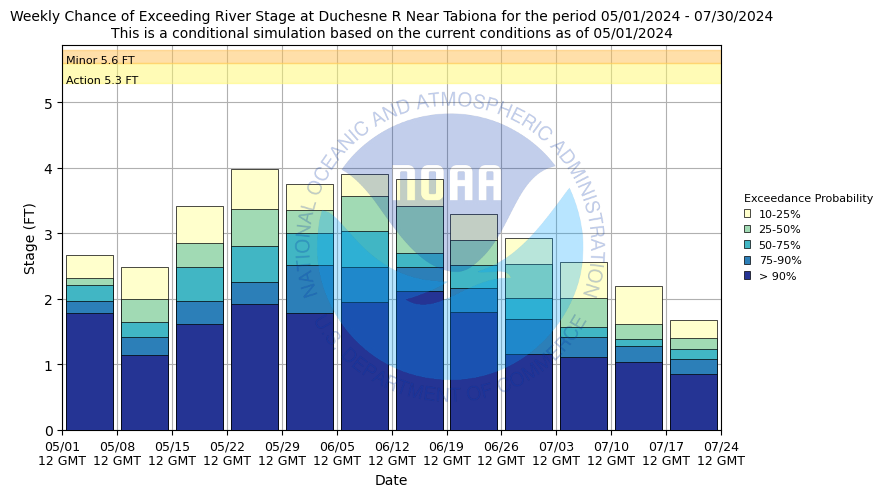
This probabilistic forecast is issued by the Colorado Basin River Forecast Center.
tab left off Hydrograph tab right off tab left off River at a Glance tab right off tab left off Download tab right off tab left on tab right on
About this graph
Forecasts for the Duchesne River near Tabiona are issued routinely year-round.
Return to Area Map

Zoom Level:16
Flood Categories (in feet)
Major Flood Stage: 6.5
Moderate Flood Stage: 5.8
Flood Stage: 5.6
Action Stage: 5.3
Low Stage (in feet): -9999

Historic Crests
(1) 5.92 ft on 06/16/1972
(2) 5.70 ft on 06/01/1997
(3) 5.63 ft on 06/06/1986
Show More Historic Crests

(P): Preliminary values subject to further review.

Recent Crests
(1) 2.78 ft on 05/28/2003
(2) 2.55 ft on 09/07/2002
(3) 3.75 ft on 05/17/2001
Show More Recent Crests

(P): Preliminary values subject to further review.

Low Water Records
(1) 0.00 ft on 06/05/1992
KML Image
Gauge LocationGauge Map Marker
Disclaimer
Latitude/Longitude Disclaimer: The gauge location shown in the above map is the approximate location based on the latitude/longitude coordinates provided to the NWS by the gauge owner.
Flood Impacts & Photos Collapse
If you notice any errors in the below information, please contact our Webmaster
6.8 major flooding along the Duchesne River from Tabiona to the town of Duchesne and downstream areas. Flood damage will affect structures, bridges and roads, especially State Route 35 and State Route 208.
5.8 moderate flooding will occur along the Duchesne River from Tabiona to Duchesne and downstream areas. Damage will affect structures, bridges and roads, especially State Route 35 and State Route 208.
5.6 minor flooding will affect structures and roads adjacent to the Duchesne River from Hanna to Duchesne and downstream areas. Some bridges and roads will be affected including State Route 35 and State Route 208.

Other Real-time and/or Archive Data Sources:

Collaborative Agencies Collapse
The National Weather Service prepares its forecasts and other services in collaboration with agencies like the US Geological Survey, US Bureau of Reclamation, US Army Corps of Engineers, Natural Resource Conservation Service, National Park Service, ALERT Users Group, Bureau of Indian Affairs, and many state and local emergency managers across the country. For details, please click here.
NWS Information
National Weather Service
Salt Lake City Weather Forecast Office
2242 West North Temple
Salt Lake City, UT 84116
(801) 524-5133
Ask Questions/Webmaster
Page last modified: 2-Nov-2020 7:28 PM
Disclaimer
Credits
Glossary
Privacy Policy
About Us
Career Opportunities