Skip Navigation Link weather.gov  
NOAA logo - Click to go to the NOAA homepage National Weather Service NWS logo - Click to go to the NWS homepage
Advanced Hydrologic Prediction Service
Image background of Navigation bar Left
Navigation Bar End Cap


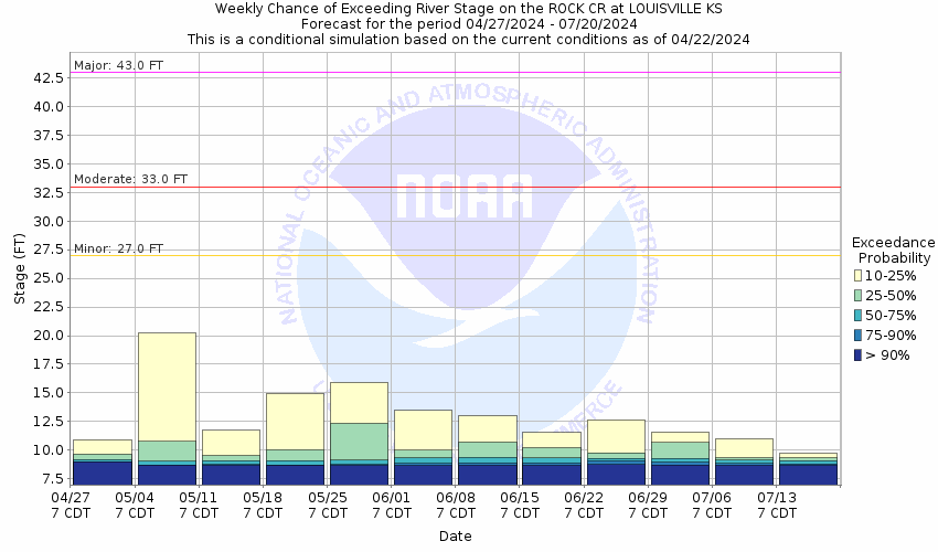
This probabilistic forecast is issued by the Missouri Basin River Forecast Center.
tab left off Hydrograph tab right off tab left off River at a Glance tab right off tab left off Download tab right off tab left on tab right on
About this graph
Forecasts for the Rock Creek (KS) at Louisville are issued as needed during times of high water, but are not routinely available.

Vertical datum height surveyed by the USGS

Return to Area Map

Zoom Level:16
Flood Categories (in feet)
Major Flood Stage: 43
Moderate Flood Stage: 33
Flood Stage: 27
Action Stage: 22
Low Stage (in feet): -9999

Historic Crests
(1) 31.70 ft on 05/24/2007
(2) 30.26 ft on 05/01/2007
(3) 29.95 ft on 05/06/2007
(4) 29.13 ft on 06/05/2015
(5) 28.14 ft on 06/23/2019
Show More Historic Crests

(P): Preliminary values subject to further review.

Recent Crests
(1) 12.29 ft on 03/27/2021
(2) 27.36 ft on 05/25/2020
(3) 28.14 ft on 06/23/2019
(4) 24.39 ft on 09/13/2018
(5) 29.13 ft on 06/05/2015
Show More Recent Crests

(P): Preliminary values subject to further review.

Low Water Records
Currently none available.
KML Image
Gauge LocationGauge Map Marker
Disclaimer
Latitude/Longitude Disclaimer: The gauge location shown in the above map is the approximate location based on the latitude/longitude coordinates provided to the NWS by the gauge owner.
Flood Impacts & Photos Collapse
If you notice any errors in the below information, please contact our Webmaster
43.1 The bridge deck of the Kansas Highway 99 bridge floods.
40.09 The intersection of Kansas Highway 99 and West Webster Road floods.
40 Water reaches the low steel of the Kansas Highway 99 bridge over Rock Creek.
36 West Webster Road floods. Fields are flooded and water is about 4 feet deep between Rock Creek and West Webster Road.
35 Homes along East Webster Road flood.
33 East Webster Road floods. The farm field is flooded and homes in the area begin to flood. The unpaved road leading to the park on the southeast side of Rock Creek floods.
32 South bank overflow begins west of the Kansas Highway 99 bridge. Water will begin to flood the adjacent farmers field.
31.7 The farm field on the north bank of Kansas Highway 99 bridge is flooded. Water begins to approach homes in the area along East Webster Road.
27 Minor low land flooding begins along the north bank of Rock Creek.
Low Water Impacts Collapse
If you notice any errors in the below information, please contact our Webmaster
8.3 Creek approaches zero flow.

Other Real-time and/or Archive Data Sources:

Additional Information Collapse
How low could the river get?
Collaborative Agencies Collapse
The National Weather Service prepares its forecasts and other services in collaboration with agencies like the US Geological Survey, US Bureau of Reclamation, US Army Corps of Engineers, Natural Resource Conservation Service, National Park Service, ALERT Users Group, Bureau of Indian Affairs, and many state and local emergency managers across the country. For details, please click here.
NWS Information
National Weather Service
Topeka Weather Forecast Office
1116 NE Strait Ave.
Topeka, KS 66616-1698
(785) 234-2592
Ask Questions/Webmaster
Page last modified: 2-Nov-2020 7:29 PM
Disclaimer
Credits
Glossary
Privacy Policy
About Us
Career Opportunities