Skip Navigation Link weather.gov  
NOAA logo - Click to go to the NOAA homepage National Weather Service NWS logo - Click to go to the NWS homepage
Advanced Hydrologic Prediction Service
Image background of Navigation bar Left
Navigation Bar End Cap


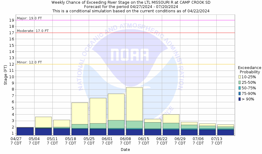
This probabilistic forecast is issued by the Missouri Basin River Forecast Center.
tab left off Hydrograph tab right off tab left off River at a Glance tab right off tab left off Download tab right off tab left on tab right on
About this graph
Forecasts for the Little Missouri River at Camp Crook are issued as needed during times of high water, but are not routinely available.
Return to Area Map

Downstream Gauge Downstream Gauge - at Marmarth
Zoom Level:14
Flood Categories (in feet)
Major Flood Stage: 19
Moderate Flood Stage: 17
Flood Stage: 12
Action Stage: 10
Low Stage (in feet): -9999

Historic Crests
(1) 19.40 ft on 05/24/2011
(2) 17.67 ft on 04/17/2009
(3) 16.90 ft on 03/24/1978
(4) 16.46 ft on 03/25/2019
(5) 16.18 ft on 03/12/2014
Show More Historic Crests

(P): Preliminary values subject to further review.

Recent Crests
(1) 9.13 ft on 06/02/2023
(2) 11.75 ft on 05/01/2022
(3) 3.65 ft on 05/29/2021
(4) 10.66 ft on 03/02/2020
(5) 16.46 ft on 03/25/2019
Show More Recent Crests

(P): Preliminary values subject to further review.

Low Water Records
Currently none available.
KML Image
Gauge LocationGauge Map Marker
Disclaimer
Latitude/Longitude Disclaimer: The gauge location shown in the above map is the approximate location based on the latitude/longitude coordinates provided to the NWS by the gauge owner.
Flood Impacts & Photos Collapse
If you notice any errors in the below information, please contact our Webmaster
19 Major Flood Stage. Water begins washing against the low steel on main highway bridge.
18 Water covers the concrete bridge supports.
17 Moderate Flood Stage. Some structural flooding is possible near the Little Missouri River.
16 Water covers erosion control walls upstream from the highway bridge. Minor flooding along lower areas of west bank begins.
14 Water overflows tree-line along the east bank. Minor flooding of pasture land.
12 Flood Stage. Water overflows lowest areas along the east bank and causes lowland pasture flooding.
Photos
(1) Flooding on 4/16/2009 - Looking northeast. Gage height around 17.6 ft.
(2) Flooding on 4/16/2009 - Looking east. Gage height around 17.6 ft.
(3) Flooding on 4/16/2009 - Looking north. Gage height around 17.6 ft.
(4) Flooding on 4/16/2009 - Looking south southwest. Gage height around 17.6 ft.
(5) Flooding on 4/16/2009 - Looking downstream, with measurement being made. Gage height around 17.6 ft.
(6) Flooding on 4/16/2009 - Looking at the Highway 20 bridge. Gage height around 17.6 ft.
(7) Flooding on 4/16/2009 - Upstream. Gage height around 17.6 ft.
(8) April 2006 - looking at gage house. Gage height about 14.8 ft.
(9) April 2006 - looking downstream from the bridge. Gage height about 14.8 ft.
(10) April 2006 - looking upstream. Gage height about 14.8 ft.
(11) April 2006 - looking south southwest from the gage house. Gage height about 14.8 ft.
(12) 3/11/2009 - Looking west, downstream side of the bridge.
(13) 3/11/2009 - Looking west, upstream side of the bridge.
(14) 3/11/2009 - Looking north, downstream side of the bridge.
(15) 3/11/2009 - Looking south, upstream side of the bridge.
(16) 5/2/2006 - Upstream from Highway 20 bridge. Gage height about 5 ft.
(17) 5/2/2006 - Downstream from Highway 20 bridge. Gage height about 5 ft.
(18) 5/2/2006 - Looking east. Gage height about 5 ft.
(19) 5/2/2006 - Looking east, across from the gage. Gage height about 5 ft.
(20) Looking upstream (summer).
(21) Looking downstream (summer).

Other Real-time and/or Archive Data Sources:

Additional Information Collapse
How low could the river get?
Collaborative Agencies Collapse
The National Weather Service prepares its forecasts and other services in collaboration with agencies like the US Geological Survey, US Bureau of Reclamation, US Army Corps of Engineers, Natural Resource Conservation Service, National Park Service, ALERT Users Group, Bureau of Indian Affairs, and many state and local emergency managers across the country. For details, please click here.
NWS Information
National Weather Service
Rapid City Weather Forecast Office
300 East Signal Drive
Rapid City, SD 57701-3800
(605) 341-7531
Ask Questions/Webmaster
Page last modified: 2-Nov-2020 7:28 PM
Disclaimer
Credits
Glossary
Privacy Policy
About Us
Career Opportunities