Des Moines River At Fort Dodge (FODI4)
Return to TopNOTE: River forecasts for this location take into account past precipitation and the precipitation amounts expected approximately 24 hours into the future from the forecast issuance time.
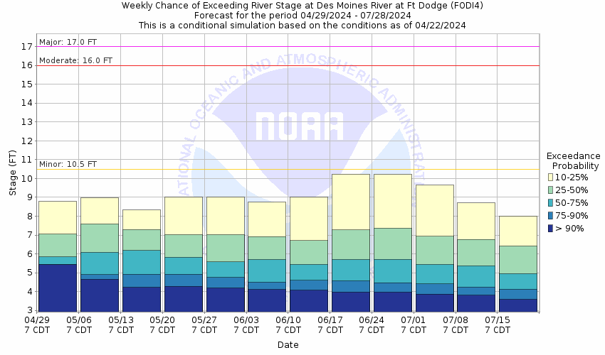
Flood Stage: 10.5 Feet
Latest Stage: 11.31
More information on datums is available at
www.ngs.noaa.gov/faq.shtmlNOTE:Forecasts for the Des Moines River at Fort Dodge are issued as needed during times of high water, but are not routinely available.
Gauge Location
Latitude/Longitude Disclaimer: The gauge location shown in the above map
is the approximate location based on the latitude/longitude coordinates
provided to the NWS by the gauge owner.
Flood ImpactsIf you notice any errors in the below information, please contact our Webmaster
17
Water reaches the bottom of the railroad trestle approach.
16
Water threatens the Phinney Park riverside trail along the west bank.
15
Water affects some residences in Lehigh and may affect Riverside Dr in northern Webster County.
14
Water affects some access roads along the river in Fort Dodge as well as in Lehigh.
13
Water affects residences along the west bank of the river in Lehigh and threatens industries near Phinney Park.
12
Water affects campgrounds in the downstream parks between Fort Dodge and Lehigh.
11
Water affects lowland areas near the river and threatens residences along the river in Fort Dodge.
10
Water affects roads to residences in Fort Dodge along the river and limits access to some subdivisions.
Flood Categories (in feet)
| Major Flood Stage: |
17 |
| Moderate Flood Stage: |
16 |
| Flood Stage: |
10.5 |
| Action Stage: |
9 |
| Low Stage (in feet): |
-9999 |
Historic Crests
(1) 20.28 ft on 06/23/1947
(2) 19.94 ft on 06/21/1954
(3) 18.45 ft on 04/08/1965
(4) 16.83 ft on 06/27/2010
(5) 16.47 ft on 04/01/1993
(6) 16.39 ft on 06/08/2008
(7) 15.60 ft on 06/19/1984
(8) 15.31 ft on 06/19/2014
(9) 15.27 ft on 03/14/2019
(10) 15.17 ft on 08/22/2007
Show More Historic Crests
(P): Preliminary values subject to further review.
Recent Crests
(1) 8.73 ft on 05/15/2023
(2) 8.58 ft on 06/16/2022
(3) 5.06 ft on 03/29/2021
(4) 9.30 ft on 03/21/2020
(5) 15.04 ft on 03/20/2019
(6) 15.27 ft on 03/14/2019
(7) 14.14 ft on 09/23/2018
(8) 14.61 ft on 03/05/2018
(9) 9.68 ft on 05/22/2017
(10) 10.21 ft on 12/18/2016
Show More Recent Crests
(P): Preliminary values subject to further review.
Low Water Records
Currently none available.
Probabilistic Stage Forecast for Fort Dodge
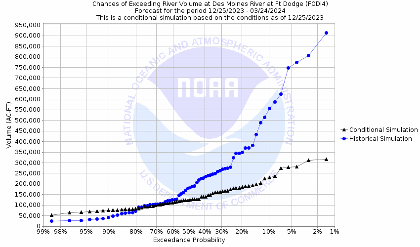
Volume Exceedance Forecast for Fort Dodge
Des Moines River Near Stratford (STRI4)
Return to TopNOTE: River forecasts for this location take into account past precipitation and the precipitation amounts expected approximately 24 hours into the future from the forecast issuance time.
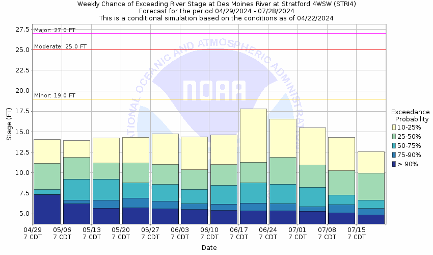
Flood Stage: 19 Feet
Latest Stage: 17.42
More information on datums is available at
www.ngs.noaa.gov/faq.shtmlNOTE:Forecasts for the Des Moines River near Stratford are issued as needed during times of high water, but are not routinely available.
Gauge Location
Latitude/Longitude Disclaimer: The gauge location shown in the above map
is the approximate location based on the latitude/longitude coordinates
provided to the NWS by the gauge owner.
Flood ImpactsIf you notice any errors in the below information, please contact our Webmaster
19
Water affects 157th St on the west side of Fraser.
18.8
Water affects the 400 block of Juniper Rd...west of Fraser. Water also affects the 1100 block of 155th St...east of Fraser.
17.8
Water affects the lower Ledges road. Water also affects 155th St east of Fraser and Juniper Rd north of Fraser.
14
Water primarily affects adjacent lowland areas.
Flood Categories (in feet)
| Major Flood Stage: |
27 |
| Moderate Flood Stage: |
25 |
| Flood Stage: |
19 |
| Action Stage: |
14 |
| Low Stage (in feet): |
-9999 |
Historic Crests
(1) 28.42 ft on 06/28/2010
(2) 27.32 ft on 06/09/2008
(3) 25.68 ft on 04/02/1993
(4) 24.08 ft on 06/19/1984
(5) 23.31 ft on 06/05/1991
(6) 23.22 ft on 08/26/1979
(7) 23.08 ft on 09/24/2018
(8) 22.89 ft on 08/23/2007
(9) 22.57 ft on 06/20/2014
(10) 22.26 ft on 03/18/2019
Show More Historic Crests
(P): Preliminary values subject to further review.
Recent Crests
(1) 13.94 ft on 05/16/2023
(2) 10.78 ft on 06/17/2022
(3) 6.94 ft on 05/23/2021
(4) 15.90 ft on 03/21/2020
(5) 22.12 ft on 03/21/2019
(6) 22.26 ft on 03/18/2019
(7) 23.08 ft on 09/24/2018
(8) 15.26 ft on 05/23/2017
(9) 19.02 ft on 12/16/2015
(10) 17.52 ft on 08/28/2015
Show More Recent Crests
(P): Preliminary values subject to further review.
Low Water Records
Currently none available.
Probabilistic Stage Forecast for Stratford
Volume Exceedance Forecast for Stratford

Des Moines River At Saylorville Reservoir (SAYI4)
Return to TopFlood Stage: 884 Feet
Latest Stage: 839.05
Current Warnings/Statements/Advisories:None currently.
More information on datums is available at
www.ngs.noaa.gov/faq.shtmlNOTE:Forecasts are not available for the Des Moines River at Saylorville Reservoir. Only observed stages are available for this point.
Gauge Location
Latitude/Longitude Disclaimer: The gauge location shown in the above map
is the approximate location based on the latitude/longitude coordinates
provided to the NWS by the gauge owner.
Flood ImpactsIf you notice any errors in the below information, please contact our Webmaster
915.5
This is the top of the Saylorville Dam.
892.83
Water reaches the low beams of the Iowa 415 bridge.
892.02
The Iowa 415 bridge is closed.
890
This is the top of the Saylorville Dam spillway when pneumatic crest gates are used. Without the crest gates...the top of the spillway is 884 feet.
886
Water affects US 30 west of Boone.
884
This is the top of the Saylorville Dam spillway when pneumatic crest gates are not used. If the pool approaches...or is forecast to exceed 884 feet then pneumatic crest gates can be used to raise the spillway elevation to 890 feet.
870
Water affects the main entrance to Jester Park.
858
Water affects Ledges State Park Rd.
847
NW Jester Park Dr is closed.
Flood Categories (in feet)
| Major Flood Stage: |
0 |
| Moderate Flood Stage: |
0 |
| Flood Stage: |
884 |
| Action Stage: |
0 |
| Low Stage (in feet): |
-9999 |
Historic Crests
(1) 892.03 ft on 07/11/1993
(2) 891.03 ft on 06/12/2008
(3) 889.25 ft on 06/22/1984
(4) 889.15 ft on 07/01/2010
(5) 888.99 ft on 06/11/1991
(6) 886.19 ft on 07/09/2018
(7) 883.59 ft on 04/06/1979
(8) 881.20 ft on 04/22/1983
(9) 880.52 ft on 03/30/2019
(10) 878.91 ft on 05/14/2001
(P)
Show More Historic Crests
(P): Preliminary values subject to further review.
Recent Crests
(1) 837.66 ft on 03/02/2023
(P)
(2) 839.17 ft on 12/26/2021
(P)
(3) 838.59 ft on 12/24/2020
(P)
(4) 844.39 ft on 06/01/2020
(P)
(5) 880.52 ft on 03/30/2019
(6) 886.19 ft on 07/09/2018
(7) 850.39 ft on 10/01/2016
(P)
(8) 865.83 ft on 12/22/2015
(P)
(9) 845.47 ft on 06/29/2015
(P)
(10) 877.57 ft on 07/06/2014
(P)
Show More Recent Crests
(P): Preliminary values subject to further review.
Low Water Records (1) 829.24 ft on 03/08/2013
(2) 831.54 ft on 01/02/2023
(3) 832.23 ft on 03/09/1989
(4) 832.41 ft on 03/03/1979
(5) 832.49 ft on 03/09/2014
Show More Low Water Records Des Moines River At Saylorville Tail (SDTI4)
Return to TopFlood Stage: Not available
Latest Stage: 11.82
Current Warnings/Statements/Advisories:None currently.
More information on datums is available at
www.ngs.noaa.gov/faq.shtmlNOTE:Forecasts are not available for the Des Moines River at Saylorville Tail. Only observed stages are available for this point.
Gauge Location
Latitude/Longitude Disclaimer: The gauge location shown in the above map
is the approximate location based on the latitude/longitude coordinates
provided to the NWS by the gauge owner.
Flood Categories (in feet)
Historic Crests
(1) 24.50 ft on 06/24/1954
(2) 24.22 ft on 07/11/1993
(3) 24.03 ft on 06/13/2008
(4) 24.02 ft on 04/10/1965
(5) 22.90 ft on 07/21/1993
(6) 21.10 ft on 04/03/1962
(7) 20.88 ft on 07/02/2010
(8) 20.72 ft on 06/22/1984
(9) 20.65 ft on 07/01/2010
(10) 20.15 ft on 04/18/1969
Show More Historic Crests
(P): Preliminary values subject to further review.
Recent Crests
(1) 11.60 ft on 05/18/2023
(2) 11.87 ft on 03/01/2023
(3) 10.39 ft on 06/17/2022
(4) 5.68 ft on 03/27/2021
(5) 15.47 ft on 03/30/2019
(6) 17.20 ft on 07/01/2018
(7) 15.51 ft on 10/01/2016
(8) 15.64 ft on 09/28/2016
(9) 13.31 ft on 12/23/2015
(10) 13.26 ft on 09/01/2015
Show More Recent Crests
(P): Preliminary values subject to further review.
Low Water Records
Currently none available.
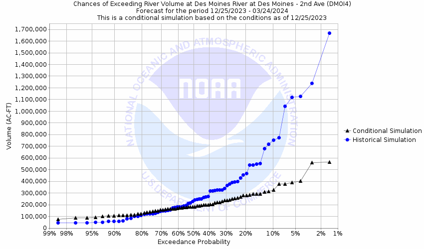
Des Moines River At Des Moines 2nd Ave (DMOI4)
Return to TopNOTE: River forecasts for this location take into account past precipitation and the precipitation amounts expected approximately 24 hours into the future from the forecast issuance time.
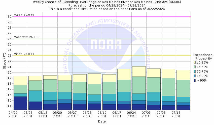
Flood Stage: 23 Feet
Latest Stage: 18.91
Current Warnings/Statements/Advisories:None currently.
More information on datums is available at
www.ngs.noaa.gov/faq.shtmlNOTE:Forecasts for the Des Moines River at Des Moines 2nd Ave are issued as needed during times of high water, but are not routinely available.
Gauge Location
Latitude/Longitude Disclaimer: The gauge location shown in the above map
is the approximate location based on the latitude/longitude coordinates
provided to the NWS by the gauge owner.
Flood ImpactsIf you notice any errors in the below information, please contact our Webmaster
37.2
This is the top of the Birdland and Central Place levees at 2nd Ave.
33
Levee closures occur across 2nd Ave.
30
Levee closures occur across Grand Ave...Locust St...Walnut St and Ct Ave in downtown Des Moines.
28.5
Martin Luther King Jr. Parkway is closed from Urbandale Ave to Euclid Ave.
27.7
Water is several feet deep against the Birdland Marina boathouse.
26.5
Euclid Ave is closed from Martin Luther King Jr. Parkway to 16th St.
26
Water is across the Polk County Human Services Department parking lot.
25.5
Water affects portions of the Polk County Human Services Department parking lot...on the north side of Euclid Ave and on the west side of the river.
25
The levee is closed across Martin Luther King Jr. Parkway north of Clarkson Ave.
24.5
Levee closures occur across Saylor Rd.
23
Water affects Birdland Park.
20.5
Prospect Rd is closed from Martin Luther King Jr. Parkway to Hickman Rd.
20
Birdland Dr is closed from Saylor Rd to 6th Ave.
18.5
Water affects low-lying sections of the Neal Smith Trail in the Birdland Park area.
Flood Categories (in feet)
| Major Flood Stage: |
30 |
| Moderate Flood Stage: |
26 |
| Flood Stage: |
23 |
| Action Stage: |
19 |
| Low Stage (in feet): |
-9999 |
Historic Crests
(1) 31.57 ft on 06/13/2008
(2) 30.16 ft on 06/24/1954
(3) 27.40 ft on 05/31/1903
(4) 26.50 ft on 06/26/1947
(5) 26.08 ft on 07/02/2010
(6) 25.25 ft on 04/01/1960
(7) 24.40 ft on 05/23/1944
(8) 24.00 ft on 07/01/2018
(9) 23.80 ft on 03/31/1951
(10) 22.55 ft on 03/31/1961
Show More Historic Crests
(P): Preliminary values subject to further review.
Recent Crests
(1) 19.88 ft on 03/01/2023
(2) 18.23 ft on 06/17/2022
(3) 14.41 ft on 03/27/2021
(4) 16.40 ft on 03/23/2021
(5) 19.37 ft on 05/28/2020
(6) 20.49 ft on 10/12/2019
(7) 21.61 ft on 03/22/2019
(8) 21.20 ft on 10/12/2018
(9) 24.00 ft on 07/01/2018
(10) 20.29 ft on 10/01/2016
Show More Recent Crests
(P): Preliminary values subject to further review.
Low Water Records
Currently none available.
Probabilistic Stage Forecast for Des Moines 2nd Ave
Volume Exceedance Forecast for Des Moines 2nd Ave
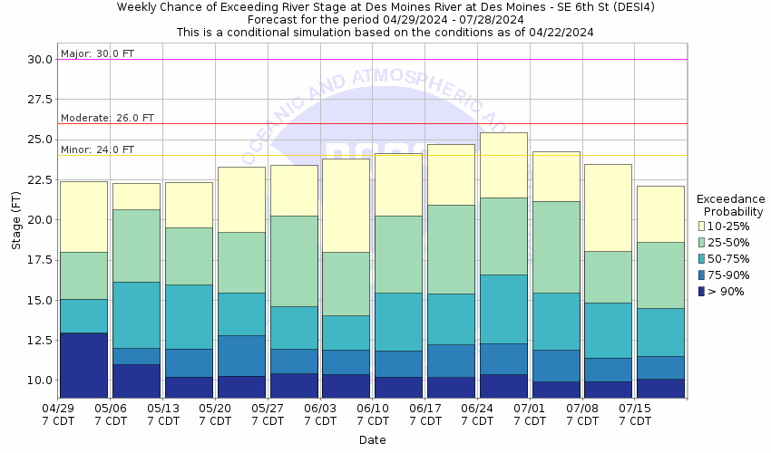
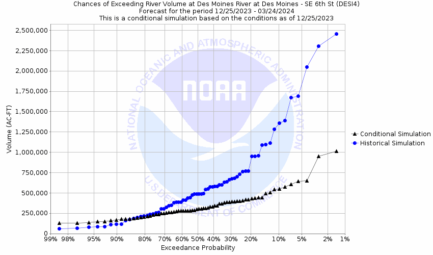
Des Moines River At Des Moines SE 6th St (DESI4)
Return to TopNOTE: River forecasts for this location take into account past precipitation and the precipitation amounts expected approximately 24 hours into the future from the forecast issuance time.
Flood Stage: 24 Feet
Latest Stage: 21.65
Current Warnings/Statements/Advisories:None currently.
More information on datums is available at
www.ngs.noaa.gov/faq.shtmlNOTE:Forecasts for the Des Moines River at Des Moines SE 6th St are issued as needed during times of high water, but are not routinely available.
Gauge Location
Latitude/Longitude Disclaimer: The gauge location shown in the above map
is the approximate location based on the latitude/longitude coordinates
provided to the NWS by the gauge owner.
Flood ImpactsIf you notice any errors in the below information, please contact our Webmaster
37.3
This is the top of the levee on the downstream side of SE 6th St.
35
Water affects the grass bowl of the Simon Estes Amphitheater.
34
Water surrounds Principal Park and approaches its entrances.
30
Water from the Des Moines River causes backwater impacts along portions of Fourmile Creek in the Vandalia Rd and S Pleasant Hill Blvd areas.
28.7
Simon Estes Amphitheater is inundated up to intersection of the arcing sidewalks.
28.5
Hartford Ave is closed from SE 22nd St to SE 30th Ct.
26.3
Water affects Arthur St east of Carlisle.
25.7
Water surrounds the base of Simon Estes Amphitheater.
24
The bike trail is closed east of Water St. Water affects portions of other bike trails.
Flood Categories (in feet)
| Major Flood Stage: |
30 |
| Moderate Flood Stage: |
26 |
| Flood Stage: |
24 |
| Action Stage: |
20 |
| Low Stage (in feet): |
-9999 |
Historic Crests
(1) 35.55 ft on 06/13/2008
(2) 34.29 ft on 07/11/1993
(3) 32.06 ft on 05/31/1903
(4) 31.96 ft on 06/26/1947
(5) 31.24 ft on 06/24/1954
(6) 30.14 ft on 06/26/2015
(7) 29.83 ft on 07/02/2010
(8) 29.78 ft on 04/11/1965
(9) 29.16 ft on 03/16/2019
(10) 28.91 ft on 03/31/1951
Show More Historic Crests
(P): Preliminary values subject to further review.
Recent Crests
(1) 21.70 ft on 03/01/2023
(2) 22.42 ft on 06/07/2022
(3) 13.54 ft on 03/27/2021
(4) 23.58 ft on 10/12/2019
(5) 29.16 ft on 03/16/2019
(6) 28.87 ft on 07/01/2018
(7) 24.15 ft on 05/24/2017
(8) 26.93 ft on 12/15/2015
(9) 30.14 ft on 06/26/2015
(10) 25.97 ft on 07/01/2014
Show More Recent Crests
(P): Preliminary values subject to further review.
Low Water Records
Currently none available.
Probabilistic Stage Forecast for Des Moines SE 6th St
Volume Exceedance Forecast for Des Moines SE 6th St
Des Moines River Near Swan (SWNI4)
Return to TopFlood Stage: Not available
Latest Stage: 51.24
Current Warnings/Statements/Advisories:None currently.
More information on datums is available at
www.ngs.noaa.gov/faq.shtmlNOTE:Forecasts are not available for the Des Moines River near Swan. Only observed stages are available for this point.
Gauge Location
Latitude/Longitude Disclaimer: The gauge location shown in the above map
is the approximate location based on the latitude/longitude coordinates
provided to the NWS by the gauge owner.
Flood Categories (in feet)
Historic Crests
(1) 79.26 ft on 07/05/2010
(2) 76.39 ft on 06/28/2011
(3) 75.72 ft on 05/31/2019
(4) 70.57 ft on 07/01/2015
(5) 67.76 ft on 06/27/2015
(6) 67.27 ft on 06/20/2013
(7) 67.18 ft on 07/10/2014
(8) 66.73 ft on 07/19/2018
(9) 63.61 ft on 12/26/2015
(10) 62.56 ft on 07/03/2018
Show More Historic Crests
(P): Preliminary values subject to further review.
Recent Crests
(1) 51.14 ft on 03/02/2023
(2) 52.52 ft on 06/09/2022
(3) 47.84 ft on 07/11/2021
(4) 54.17 ft on 10/14/2019
(5) 75.72 ft on 05/31/2019
(6) 66.73 ft on 07/19/2018
(7) 62.56 ft on 07/03/2018
(8) 53.36 ft on 05/25/2017
(9) 52.74 ft on 04/06/2017
(10) 63.61 ft on 12/26/2015
Show More Recent Crests
(P): Preliminary values subject to further review.
Low Water Records
Currently none available.
Des Moines River At Red Rock Reservoir (PELI4)
Return to TopFlood Stage: 780 Feet
Latest Stage: 741.79
Current Warnings/Statements/Advisories:None currently.
More information on datums is available at
www.ngs.noaa.gov/faq.shtmlNOTE:Forecasts are not available for the Des Moines River at Red Rock Reservoir. Only observed stages are available for this point.
Gauge Location
Latitude/Longitude Disclaimer: The gauge location shown in the above map
is the approximate location based on the latitude/longitude coordinates
provided to the NWS by the gauge owner.
Flood ImpactsIf you notice any errors in the below information, please contact our Webmaster
797
This is the top of the Red Rock Dam.
796
This is the highest elevation of the southeast Des Moines and Pleasant Hill levees.
789.1
This is the low point of the southeast Des Moines and Pleasant Hill levees.
789
Water affects Vandalia Rd in Des Moines.
788
This is the top of the Carlisle and Avon levees.
782.4
Water affects the access road to Wallashuck.
782.35
Water affects Highway G28 near the Brush Creek fishing bridge.
780
This is the top of the Red Rock Dam spillway.
766
Water affects the access road to North Overlook.
748.3
Water reaches the bridge deck of the Roche St bridge.
748
Water reaches the bridge deck of the Competine Creek bridge.
746.3
Water affects the west approach to the Competine Creek bridge.
Flood Categories (in feet)
| Major Flood Stage: |
0 |
| Moderate Flood Stage: |
0 |
| Flood Stage: |
780 |
| Action Stage: |
0 |
| Low Stage (in feet): |
-9999 |
Historic Crests
(1) 782.67 ft on 07/13/1993
(2) 779.61 ft on 06/25/1984
(3) 779.32 ft on 06/21/1991
(4) 779.10 ft on 06/14/2008
(5) 778.81 ft on 07/05/2010
(6) 777.95 ft on 05/14/1973
(7) 777.72 ft on 05/18/1993
(8) 775.84 ft on 06/29/2011
(P)
(9) 774.92 ft on 05/31/2019
(P)
(10) 774.00 ft on 05/29/1983
(P)
Show More Historic Crests
(P): Preliminary values subject to further review.
Recent Crests
(1) 744.37 ft on 12/15/2022
(P)
(2) 747.28 ft on 12/30/2021
(P)
(3) 745.81 ft on 12/24/2020
(P)
(4) 752.79 ft on 10/16/2019
(P)
(5) 774.92 ft on 05/31/2019
(P)
(6) 766.21 ft on 07/20/2018
(P)
(7) 751.37 ft on 05/31/2017
(P)
(8) 762.46 ft on 12/27/2015
(P)
(9) 769.96 ft on 07/02/2015
(P)
(10) 766.66 ft on 07/11/2014
(P)
Show More Recent Crests
(P): Preliminary values subject to further review.
Low Water Records (1) 719.68 ft on 02/18/1977
(2) 721.92 ft on 01/01/1974
(3) 722.73 ft on 01/15/1975
(4) 722.81 ft on 12/28/1972
(5) 724.57 ft on 11/19/1970
Show More Low Water Records Des Moines River At Red Rock Tail (RRDI4)
Return to TopFlood Stage: Not available
Latest Stage: 692.99
Current Warnings/Statements/Advisories:None currently.
More information on datums is available at
www.ngs.noaa.gov/faq.shtmlNOTE:Forecasts are not available for the Des Moines River at Red Rock Tail. Only observed stages are available for this point.
Gauge Location
Latitude/Longitude Disclaimer: The gauge location shown in the above map
is the approximate location based on the latitude/longitude coordinates
provided to the NWS by the gauge owner.
Flood Categories (in feet)
Historic Crests
(1) 709.71 ft on 07/12/1993
(2) 708.96 ft on 06/14/2008
(3) 701.24 ft on 07/06/2010
(4) 699.43 ft on 06/06/2019
(5) 697.64 ft on 10/01/1993
(6) 697.31 ft on 04/20/1999
(7) 696.92 ft on 04/20/1998
(8) 696.44 ft on 03/19/2007
(9) 696.39 ft on 07/20/2011
(10) 696.37 ft on 01/10/2016
Show More Historic Crests
(P): Preliminary values subject to further review.
Recent Crests
(1) 694.47 ft on 03/02/2023
(2) 692.49 ft on 06/09/2022
(3) 690.93 ft on 07/12/2021
(4) 694.71 ft on 03/26/2020
(5) 699.43 ft on 06/06/2019
(6) 693.68 ft on 08/10/2018
(7) 694.90 ft on 04/01/2017
(8) 696.37 ft on 01/10/2016
(9) 693.86 ft on 06/29/2015
(10) 693.77 ft on 07/13/2014
Show More Recent Crests
(P): Preliminary values subject to further review.
Low Water Records
Currently none available.
Des Moines River Near Tracy (TRCI4)
Return to TopFlood Stage: 14 Feet
Latest Stage: 9.22
Current Warnings/Statements/Advisories:None currently.
More information on datums is available at
www.ngs.noaa.gov/faq.shtmlNOTE:Forecasts are not available for the Des Moines River near Tracy. Only observed stages are available for this point.
Gauge Location
Latitude/Longitude Disclaimer: The gauge location shown in the above map
is the approximate location based on the latitude/longitude coordinates
provided to the NWS by the gauge owner.
Flood ImpactsIf you notice any errors in the below information, please contact our Webmaster
24
Water affects the town of Harvey.
23
Portions of Iowa 92 east of Harvey are likely underwater.
22
Water approaches parts of Iowa 92.
20
Water threatens several residences in the vicinity of Bellefontaine and affects rural roads east and southeast of the intersection of Ashland Ave and Water St.
19
Water affects rural gravel roads in the flood plain.
17
Widespread agricultural flooding occurs primarily downstream of Tracy on the north bank.
14
Minimal flooding impacts occur at this level. The town of Tracy is situated on high ground and is generally not affected by flooding.
Flood Categories (in feet)
| Major Flood Stage: |
23 |
| Moderate Flood Stage: |
20 |
| Flood Stage: |
14 |
| Action Stage: |
13 |
| Low Stage (in feet): |
-9999 |
Historic Crests
(1) 26.50 ft on 06/14/1947
(2) 25.00 ft on 05/31/1903
(3) 24.16 ft on 07/12/1993
(4) 23.70 ft on 06/14/2008
(5) 23.17 ft on 04/11/1965
(6) 23.00 ft on 04/04/1960
(7) 22.14 ft on 06/27/1954
(8) 21.60 ft on 05/23/1944
(9) 20.69 ft on 04/05/1962
(10) 20.38 ft on 06/17/1967
Show More Historic Crests
(P): Preliminary values subject to further review.
Recent Crests
(1) 10.35 ft on 03/02/2023
(2) 8.73 ft on 06/08/2022
(3) 7.39 ft on 07/11/2021
(4) 10.66 ft on 03/25/2020
(5) 15.18 ft on 06/06/2019
(6) 9.76 ft on 05/22/2018
(7) 11.27 ft on 04/05/2017
(8) 13.01 ft on 12/24/2015
(9) 13.20 ft on 06/26/2015
(10) 10.23 ft on 07/13/2014
Show More Recent Crests
(P): Preliminary values subject to further review.
Low Water Records
Currently none available.
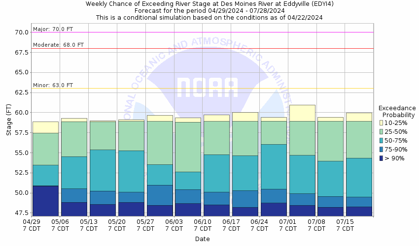
Des Moines River Near Eddyville (EDYI4)
Return to TopNOTE: River forecasts for this location take into account past precipitation and the precipitation amounts expected approximately 24 hours into the future from the forecast issuance time.
Flood Stage: 63 Feet
Latest Stage: 58.08
Current Warnings/Statements/Advisories:None currently.
More information on datums is available at
www.ngs.noaa.gov/faq.shtmlNOTE:Forecasts for the Des Moines River near Eddyville are issued as needed during times of high water, but are not routinely available.
Gauge Location
Latitude/Longitude Disclaimer: The gauge location shown in the above map
is the approximate location based on the latitude/longitude coordinates
provided to the NWS by the gauge owner.
Flood ImpactsIf you notice any errors in the below information, please contact our Webmaster
70
Sandbagging of the levee at Eddyville occurs.
67
Water affects Highway G71 north of Eddyville preventing access to residences and properties.
63.8
Extensive lowland flooding occurs along US 63 south of Eddyville. Water affects some gravel roads.
63
Water from storm drains begins flooding the lower streets in town. Pumping of water over the levee also begins.
Flood Categories (in feet)
| Major Flood Stage: |
70 |
| Moderate Flood Stage: |
68 |
| Flood Stage: |
63 |
| Action Stage: |
60 |
| Low Stage (in feet): |
-9999 |
Historic Crests
(1) 72.00 ft on 07/12/1993
(2) 71.87 ft on 06/16/2008
(3) 68.92 ft on 02/23/2015
(4) 68.68 ft on 08/11/2010
(5) 66.64 ft on 06/26/1984
(6) 65.94 ft on 05/02/1999
(P)
(7) 65.49 ft on 05/30/2019
(P)
(8) 64.90 ft on 04/19/1991
(P)
(9) 64.24 ft on 04/19/2013
(P)
(10) 63.93 ft on 04/04/1998
(P)
Show More Historic Crests
(P): Preliminary values subject to further review.
Recent Crests
(1) 56.03 ft on 07/12/2021
(P)
(2) 60.07 ft on 03/28/2020
(P)
(3) 65.49 ft on 05/30/2019
(P)
(4) 58.60 ft on 05/03/2018
(P)
(5) 61.58 ft on 04/06/2017
(P)
(6) 62.67 ft on 12/14/2015
(P)
(7) 68.92 ft on 02/23/2015
(8) 60.50 ft on 09/10/2014
(P)
(9) 64.24 ft on 04/19/2013
(P)
(10) 59.42 ft on 04/18/2012
(P)
Show More Recent Crests
(P): Preliminary values subject to further review.
Low Water Records (1) 46.43 ft on 02/17/2021
(2) 46.54 ft on 07/08/2015
(3) 46.95 ft on 05/20/2020
(4) 46.96 ft on 01/31/2019
(5) 47.17 ft on 12/25/2012
Show More Low Water Records
Probabilistic Stage Forecast for Eddyville
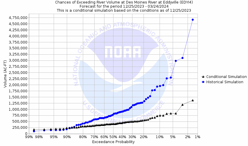
Volume Exceedance Forecast for Eddyville
Des Moines River At Ottumwa (OTMI4)
Return to TopNOTE: River forecasts for this location take into account past precipitation and the precipitation amounts expected approximately 24 hours into the future from the forecast issuance time.
Flood Stage: 11.5 Feet
Latest Stage: 8.55
Current Warnings/Statements/Advisories:None currently.
More information on datums is available at
www.ngs.noaa.gov/faq.shtmlNOTE:Forecasts for the Des Moines River at Ottumwa are issued as needed during times of high water, but are not routinely available.
Gauge Location
Latitude/Longitude Disclaimer: The gauge location shown in the above map
is the approximate location based on the latitude/longitude coordinates
provided to the NWS by the gauge owner.
Flood ImpactsIf you notice any errors in the below information, please contact our Webmaster
25
The City of Ottumwa is protected by a 25 foot levee.
23
The levee opening at the south end of the Market St bridge may need to be planked and sandbagged.
22
Sandbagging and planking operations may be needed for openings along Vine St.
19.5
Water affects the Market St parking lot. The entrance to the Market St bridge is sandbagged.
18.5
Sewer backup will reach the road surface at Market St and Commercial St.
18
Water affects the Fairport area along the railroad tracks. Sandbagging may be needed at the Vine St diversion chamber. Evacuations may begin at the trailer court.
17.5
Sewer backup in basements occurs at businesses along Main St.
17
Water affects Paris St. The Market St bridge is closed.
15
Flooding occurs in rural areas both upstream and downstream of Ottumwa.
12
Water affects Eldon.
11.5
Water affects the northeast side of Rabbit Run Rd.
11
Bear Creek reaches bankfull.
10
Agricultural flooding occurs along most of the reach between Ottumwa and Eldon.
9
Water affects rural fields primarily downstream of Ottumwa.
Flood Categories (in feet)
| Major Flood Stage: |
19 |
| Moderate Flood Stage: |
15 |
| Flood Stage: |
11.5 |
| Action Stage: |
9 |
| Low Stage (in feet): |
-9999 |
Historic Crests
(1) 22.15 ft on 07/12/1993
(2) 20.97 ft on 06/07/1947
(3) 20.60 ft on 06/17/2008
(4) 20.23 ft on 05/31/1903
(5) 20.04 ft on 08/11/2010
(6) 18.33 ft on 04/11/1965
(7) 18.27 ft on 05/24/1944
(8) 18.26 ft on 04/01/1960
(9) 17.66 ft on 06/28/1954
(10) 17.63 ft on 06/10/1917
Show More Historic Crests
(P): Preliminary values subject to further review.
Recent Crests
(1) 10.00 ft on 03/02/2023
(2) 8.86 ft on 06/09/2022
(3) 9.04 ft on 02/28/2021
(4) 11.30 ft on 03/28/2020
(5) 16.28 ft on 05/29/2019
(6) 8.96 ft on 09/06/2018
(7) 12.03 ft on 04/05/2017
(8) 12.61 ft on 12/14/2015
(9) 13.74 ft on 06/26/2015
(10) 12.17 ft on 09/10/2014
Show More Recent Crests
(P): Preliminary values subject to further review.
Low Water Records
Currently none available.
Probabilistic Stage Forecast for Ottumwa
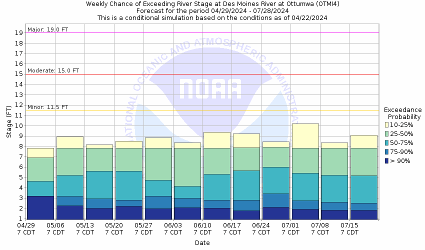
Volume Exceedance Forecast for Ottumwa

Des Moines River At Keosauqua (KEQI4)
Return to TopNOTE: River forecasts for this location take into account past precipitation and the precipitation amounts expected approximately 24 hours into the future from the forecast issuance time.
Flood Stage: 22 Feet
Latest Stage: 16.69
Current Warnings/Statements/Advisories:None currently.
NOTE:Forecasts for the Des Moines River at Keosauqua are issued routinely during the warm season, and as needed at other times of the year.
Gauge Location
Latitude/Longitude Disclaimer: The gauge location shown in the above map
is the approximate location based on the latitude/longitude coordinates
provided to the NWS by the gauge owner.
Flood ImpactsIf you notice any errors in the below information, please contact our Webmaster
38
Water affects nearly all of downtown Keosauqua.
36
Water reaches the bottom of the Iowa Highway 1 bridge deck at Keosauqua.
35
Water affects much of downtown Keosauqua.
33.5
Water reaches the bottom of the County Rd J40 bridge deck at Bonaparte.
33
Water reaches a critical level for levees 30 to 50 miles downstream of Keosauqua.
32.5
Water is 1 to 2 feet deep in areas of downtown Keosauqua.
30.5
Water is at the base of the Hotel Manning in Keosauqua.
30
Water affects downtown sections of Keosauqua as well as First Street and the County Road J40 bridge approach in Bonaparte.
29
Water affects residential and commercial areas in Bonaparte.
28
Water affects streets in Keosauqua and affects the approach to the Highway 1 bridge. Water also affects residential areas in Farmington and Bentonsport.
27
Water is over the river banks in Selma, Keosauqua, Bentonsport, Bonaparte, and Farmington.
25
Flooding occurs in Keosauqua, Selma, Bonaparte, and Farmington. Water affects streets near the nursery on the east end of Keosauqua.
22
Water affects low-lying agricultural areas.
Flood Categories (in feet)
| Major Flood Stage: |
27 |
| Moderate Flood Stage: |
25 |
| Flood Stage: |
22 |
| Action Stage: |
21 |
| Low Stage (in feet): |
-9999 |
Historic Crests
(1) 32.66 ft on 07/13/1993
(2) 30.49 ft on 06/16/2008
(3) 28.18 ft on 08/12/2010
(4) 28.02 ft on 04/21/1973
(5) 27.88 ft on 05/29/2019
(6) 27.85 ft on 06/01/1903
(7) 27.23 ft on 04/24/1976
(8) 27.14 ft on 07/17/1982
(9) 27.12 ft on 04/18/2013
(10) 26.39 ft on 05/17/1986
Show More Historic Crests
(P): Preliminary values subject to further review.
Recent Crests
(1) 19.63 ft on 06/10/2020
(2) 27.88 ft on 05/29/2019
(3) 19.11 ft on 09/06/2018
(4) 21.29 ft on 04/06/2017
(5) 22.81 ft on 12/14/2015
(6) 23.22 ft on 06/26/2015
(7) 21.60 ft on 09/10/2014
(8) 27.12 ft on 04/18/2013
(9) 16.48 ft on 04/19/2012
(10) 25.11 ft on 06/15/2011
Show More Recent Crests
(P): Preliminary values subject to further review.
Low Water Records
Currently none available.
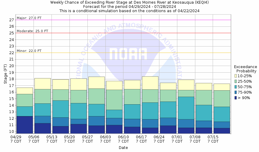
Probabilistic Stage Forecast for Keosauqua
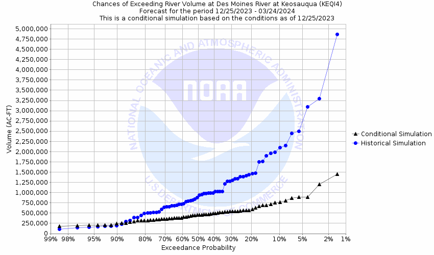
Volume Exceedance Forecast for Keosauqua
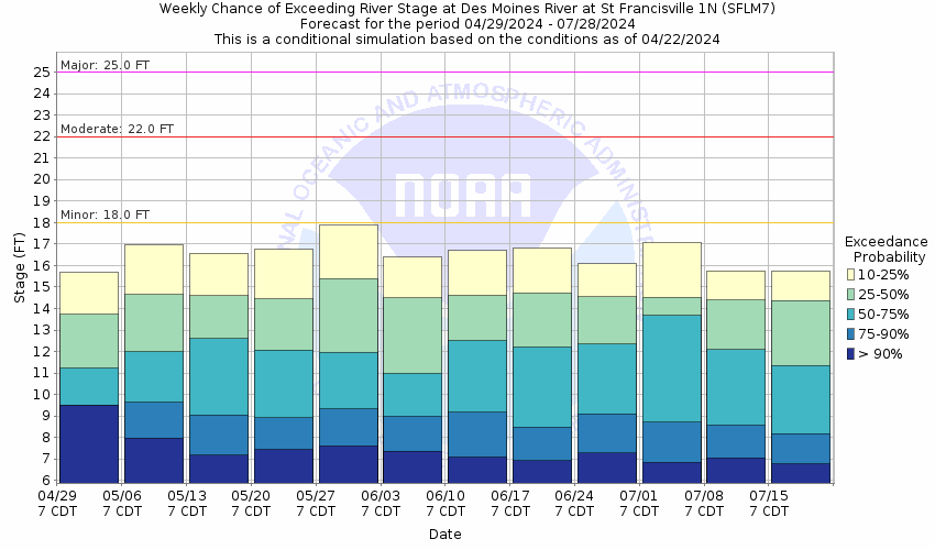
Des Moines River At St. Francisville (SFLM7)
Return to TopNOTE: River forecasts for this location take into account past precipitation and the precipitation amounts expected approximately 24 hours into the future from the forecast issuance time.
Flood Stage: 18 Feet
Latest Stage: 15.2
Current Warnings/Statements/Advisories:None currently.
NOTE:Forecasts for the Des Moines River at St. Francisville are issued as needed during times of high water, but are not routinely available.
Gauge Location
Latitude/Longitude Disclaimer: The gauge location shown in the above map
is the approximate location based on the latitude/longitude coordinates
provided to the NWS by the gauge owner.
Flood ImpactsIf you notice any errors in the below information, please contact our Webmaster
33
Water affects the gas station in St. Francisville.
32.5
Water affects Route B in St. Francisville a well as a gas station.
31
Water reaches the bottom of the St. Francisville toll bridge deck.
30
Water overtops some agricultural levees and affects the town of Croton.
25
Water affects a few homes in St. Francisville and the Fort Pike access area.
22
Water rises over the higher river banks.
21
Agricultural flooding occurs in areas along the river not protected by levees.
20
The St. Francisville boat ramp is under water.
18
Flooding occurs over the lower river banks.
Flood Categories (in feet)
| Major Flood Stage: |
25 |
| Moderate Flood Stage: |
22 |
| Flood Stage: |
18 |
| Action Stage: |
17 |
| Low Stage (in feet): |
-9999 |
Historic Crests
(1) 32.02 ft on 07/15/1993
(2) 30.15 ft on 03/14/1979
(3) 28.22 ft on 01/19/1973
(4) 28.21 ft on 06/17/2008
(5) 27.86 ft on 05/29/2019
(P)
(6) 27.55 ft on 06/09/1947
(7) 26.55 ft on 04/19/2013
(P)
(8) 26.30 ft on 05/18/1986
(9) 26.27 ft on 04/24/1976
(10) 26.15 ft on 04/12/1965
Show More Historic Crests
(P): Preliminary values subject to further review.
Recent Crests
(1) 18.55 ft on 06/10/2020
(P)
(2) 27.86 ft on 05/29/2019
(P)
(3) 19.22 ft on 05/23/2019
(P)
(4) 20.39 ft on 05/20/2019
(P)
(5) 18.50 ft on 03/14/2019
(P)
(6) 21.95 ft on 02/04/2019
(P)
(7) 19.29 ft on 01/09/2016
(P)
(8) 18.06 ft on 12/28/2015
(P)
(9) 19.11 ft on 12/25/2015
(P)
(10) 18.64 ft on 12/22/2015
(P)
Show More Recent Crests
(P): Preliminary values subject to further review.
Low Water Records
Currently none available.
Probabilistic Stage Forecast for St. Francisville
Volume Exceedance Forecast for St. Francisville


