Flood ImpactsIf you notice any errors in the below information, please contact our Webmaster
30
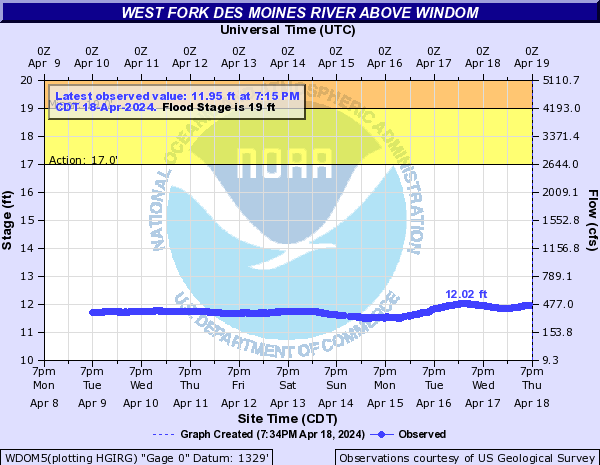
The bridge at the gage location on Country Club Dr is overtopped and nearby homes are flooded. Portions of County Road 13 begin to flood.
27
The main levee at the golf course in Windom is overtopped.
25
Water approaches Hwy 71 in Windom.
24
Water reaches the bottom beams of the bridge on Country Club Dr.
23
Water begins to approach at least a couple home and businesses in Windom. Water also approaches River Rd southeast of 15th Ave and at least one private driveway is flooded off of Country Club Dr.
22
Water begins to approach or flood some some outbuildings near Valley Ln and also south of 6th St.
21
The lower portions of the road through Island Park are overtopped and water approaches a couple of the gravel parking lots on the east side of Hwy 71 in Windom.
19
Lowland flooding begins along several stretches of the river and Island Park in Windom floods in several areas.
18
The boat launch area off of River Rd begins to flood.
17
The lower parking lot on the south side of Island Park begins to flood.
15
The lower banks at Island Park begin to overflow.
Flood Categories (in feet)
| Major Flood Stage: |
25 |
| Moderate Flood Stage: |
21 |
| Flood Stage: |
19 |
| Action Stage: |
17 |
| Low Stage (in feet): |
-9999 |
Historic Crests
(1) 24.70 ft on 07/10/1969
(2) 23.40 ft on 07/07/2018
(3) 23.01 ft on 03/23/2019
(4) 23.00 ft on 09/24/2010
(5) 21.90 ft on 04/04/1984
Show More Historic Crests
(P): Preliminary values subject to further review.
Recent Crests
(1) 18.13 ft on 04/17/2023
(2) 17.64 ft on 06/13/2022
(3) 12.57 ft on 04/12/2021
(4) 19.77 ft on 03/10/2020
(5) 23.01 ft on 03/23/2019
Show More Recent Crests
(P): Preliminary values subject to further review.
Low Water Records
Currently none available.