Skip Navigation Link weather.gov  
NOAA logo - Click to go to the NOAA homepage National Weather Service NWS logo - Click to go to the NWS homepage
Advanced Hydrologic Prediction Service
Image background of Navigation bar Left
Navigation Bar End Cap

Red River At Grand Ecore (GREL1)

Return to Top
NOTE: River forecasts for this location take into account past precipitation and the precipitation amounts expected approximately 24 hours into the future from the forecast issuance time.
Flood Stage: 33 Feet
Latest Stage: 31.24
Current Warnings/Statements/Advisories:Flood Warning
at Grand Ecore
Stage (ft)Flow (kcfs)Observed: 30.46 ft at 12:00PM Apr 13, 2024Observed: 30.51 ft at 1:00PM Apr 13, 2024Observed: 30.57 ft at 2:00PM Apr 13, 2024Observed: 30.62 ft at 3:00PM Apr 13, 2024Observed: 30.64 ft at 4:00PM Apr 13, 2024Observed: 30.68 ft at 5:00PM Apr 13, 2024Observed: 30.73 ft at 6:00PM Apr 13, 2024Observed: 30.76 ft at 7:00PM Apr 13, 2024Observed: 30.76 ft at 8:00PM Apr 13, 2024Observed: 30.81 ft at 9:00PM Apr 13, 2024Observed: 30.83 ft at 10:00PM Apr 13, 2024Observed: 30.87 ft at 11:00PM Apr 13, 2024Observed: 30.91 ft at 12:00AM Apr 14, 2024Observed: 30.93 ft at 1:00AM Apr 14, 2024Observed: 30.96 ft at 2:00AM Apr 14, 2024Observed: 30.96 ft at 3:00AM Apr 14, 2024Observed: 30.99 ft at 4:00AM Apr 14, 2024Observed: 31 ft at 5:00AM Apr 14, 2024Observed: 31.02 ft at 6:00AM Apr 14, 2024Observed: 31.05 ft at 7:00AM Apr 14, 2024Observed: 31.05 ft at 8:00AM Apr 14, 2024Observed: 31.07 ft at 9:00AM Apr 14, 2024Observed: 31.09 ft at 10:00AM Apr 14, 2024Observed: 31.12 ft at 11:00AM Apr 14, 2024Observed: 31.13 ft at 12:00PM Apr 14, 2024Observed: 31.17 ft at 1:00PM Apr 14, 2024Observed: 31.17 ft at 2:00PM Apr 14, 2024Observed: 31.22 ft at 3:00PM Apr 14, 2024Observed: 31.23 ft at 4:00PM Apr 14, 2024Observed: 31.26 ft at 5:00PM Apr 14, 2024Observed: 31.27 ft at 6:00PM Apr 14, 2024Observed: 31.33 ft at 7:00PM Apr 14, 2024Observed: 31.34 ft at 8:00PM Apr 14, 2024Observed: 31.34 ft at 9:00PM Apr 14, 2024Observed: 31.38 ft at 10:00PM Apr 14, 2024Observed: 31.38 ft at 11:00PM Apr 14, 2024Observed: 31.42 ft at 2:00AM Apr 15, 2024Observed: 31.44 ft at 3:00AM Apr 15, 2024Observed: 31.47 ft at 4:00AM Apr 15, 2024Observed: 31.46 ft at 5:00AM Apr 15, 2024Observed: 31.45 ft at 6:00AM Apr 15, 2024Observed: 31.48 ft at 7:00AM Apr 15, 2024Observed: 31.5 ft at 8:00AM Apr 15, 2024Observed: 31.5 ft at 9:00AM Apr 15, 2024Observed: 31.53 ft at 10:00AM Apr 15, 2024Observed: 31.52 ft at 11:00AM Apr 15, 2024Observed: 31.53 ft at 12:00PM Apr 15, 2024Highest Observation: 31.54 ft at 1:00PM Apr 15, 2024Observed: 31.52 ft at 2:00PM Apr 15, 2024Observed: 31.51 ft at 3:00PM Apr 15, 2024Observed: 31.49 ft at 4:00PM Apr 15, 2024Observed: 31.49 ft at 5:00PM Apr 15, 2024Observed: 31.49 ft at 6:00PM Apr 15, 2024Observed: 31.48 ft at 7:00PM Apr 15, 2024Observed: 31.48 ft at 8:00PM Apr 15, 2024Observed: 31.44 ft at 9:00PM Apr 15, 2024Observed: 31.44 ft at 10:00PM Apr 15, 2024Observed: 31.42 ft at 11:00PM Apr 15, 2024Observed: 31.42 ft at 12:00AM Apr 16, 2024Observed: 31.38 ft at 1:00AM Apr 16, 2024Observed: 31.33 ft at 2:00AM Apr 16, 2024Observed: 31.34 ft at 3:00AM Apr 16, 2024Observed: 31.32 ft at 4:00AM Apr 16, 2024Observed: 31.33 ft at 5:00AM Apr 16, 2024Observed: 31.29 ft at 7:00AM Apr 16, 2024Observed: 31.27 ft at 8:00AM Apr 16, 2024Observed: 31.26 ft at 9:00AM Apr 16, 2024Observed: 31.24 ft at 10:00AM Apr 16, 2024Highest Forecast: 31.2 ft 1:00PM Apr 16, 2024Forecast: 31 ft 7:00PM Apr 16, 2024Forecast: 30.8 ft 1:00AM Apr 17, 2024Forecast: 30.6 ft 7:00AM Apr 17, 2024Forecast: 30.4 ft 1:00PM Apr 17, 2024Forecast: 30.1 ft 7:00PM Apr 17, 2024Forecast: 29.8 ft 1:00AM Apr 18, 2024Forecast: 29.6 ft 7:00AM Apr 18, 2024Forecast: 29.3 ft 1:00PM Apr 18, 2024Forecast: 29 ft 7:00PM Apr 18, 2024Forecast: 28.8 ft 1:00AM Apr 19, 2024Forecast: 28.6 ft 7:00AM Apr 19, 2024Forecast: 28.4 ft 1:00PM Apr 19, 2024Forecast: 28.1 ft 7:00PM Apr 19, 2024Forecast: 27.9 ft 1:00AM Apr 20, 2024Forecast: 27.6 ft 7:00AM Apr 20, 2024Forecast: 27.3 ft 1:00PM Apr 20, 2024Forecast: 27.1 ft 7:00PM Apr 20, 2024Forecast: 26.8 ft 1:00AM Apr 21, 2024Forecast: 26.6 ft 7:00AM Apr 21, 2024US Army Corps of EngineersGREL1(plotting HGIRG) Graph Created (11:06AM Apr 16, 2024)ObservedForecast (issued 9:39AM Apr 16)Latest observed value: 31.24 ft at 10:00 AM CDT 16-Apr-2024. Flood Stage is 33 ft
KML Image
Gauge LocationGauge Map Marker
Latitude/Longitude Disclaimer: The gauge location shown in the above map is the approximate location based on the latitude/longitude coordinates provided to the NWS by the gauge owner.
Flood Impacts

If you notice any errors in the below information, please contact our Webmaster

45
Record flooding of tens of thousands of acres with most of the levees overtopped or in the process of being overtopped in the Powhattan area. Expect severe backwater flooding of all tribuatary bayous. Travel becomes very difficult as multiple U.S., Louisiana state, parish, and local highways flood and close. The Kansas City Southern Railroad floods and closes.
42
Several thousand acres of floodplain inundated and also including the ditches of the northbound lanes of Interstate 49 northwest of Natchitoches. Expect major backwater flooding into Black, Clear, and Saline Lakes. U.S. Highway 71 may close.
41
Severe backwater flooding along Bayou Pierre with backup of water into Black, Clear and Saline lakes will take place. Also expect several thousand acres of floodplain inundated near the levees.
40
Major backwater flooding problems will affect Bayou Pierre, Black and Saline Bayous and the Cane River Lake tributaries with thousands of acres flooded. Severe backwater flooding will spread upstream along Bayou Pierre through Powhattan and Evelyn, Louisiana. Also expect backwater flooding of Black and Clear lakes along with the closure of Louisiana highway 1226.
38
Expect several hundred acres of floodplain inundated near the levees. Also expect major backwater flooding up through Bayou Pierre to between Powhattan and Evelyn, Louisiana. Also expect backwater flooding up through Iatt, Nantaches, and Black, Clear, and Saline Bayous.
36
Minor lowland flooding of several hundred acres both upstream and downstream from Grand Ecore take place with backwater flooding of tributary bayous that include Bayou Pierre up through Powhattan, Louisiana. Backwater flooding also affects Iatt, Saline, Black, and Nantaches Bayous. Move livestock and equipment to higher ground away from levees.
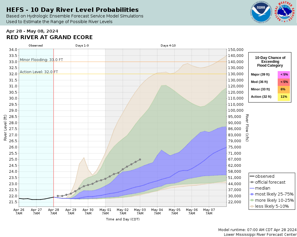
33
Minor flooding of lowlands in the Red River floodplain between levees take place.
Flood Categories (in feet)
Major Flood Stage: 39
Moderate Flood Stage: 36
Flood Stage: 33
Action Stage: 32
Low Stage (in feet): -9999

Historic Crests
(1) 44.70 ft on 04/10/1945
(2) 42.03 ft on 06/13/2015
(3) 42.00 ft on 05/10/1957
(4) 41.90 ft on 05/11/1958
(5) 41.89 ft on 03/17/2016
Show More Historic Crests

(P): Preliminary values subject to further review.

Recent Crests
(1) 36.97 ft on 05/15/2019
(2) 37.67 ft on 03/06/2018
(3) 35.85 ft on 05/07/2016
(4) 41.89 ft on 03/17/2016
(5) 34.79 ft on 01/05/2016
Show More Recent Crests

(P): Preliminary values subject to further review.

Low Water Records
(1) 2.60 ft on 10/12/1988
(2) 4.60 ft on 11/05/1978
(3) 4.91 ft on 10/05/1956
Show More Low Water Records

Observed and Forecast Stages

Observed Data:
Date (UTC)
Stage
Flow
04/16 15:00
31.24 ft
123 kcfs
04/16 14:00
31.26 ft
123 kcfs
04/16 13:00
31.27 ft
123 kcfs
04/16 12:00
31.29 ft
124 kcfs
04/16 10:00
31.33 ft
124 kcfs
04/16 09:00
31.32 ft
124 kcfs
04/16 08:00
31.34 ft
124 kcfs
04/16 07:00
31.33 ft
124 kcfs
04/16 06:00
31.38 ft
124 kcfs
04/16 05:00
31.42 ft
125 kcfs
04/16 04:00
31.42 ft
125 kcfs
04/16 03:00
31.44 ft
125 kcfs
04/16 02:00
31.44 ft
125 kcfs
04/16 01:00
31.48 ft
125 kcfs
04/16 00:00
31.48 ft
125 kcfs
04/15 23:00
31.49 ft
125 kcfs
04/15 22:00
31.49 ft
125 kcfs
04/15 21:00
31.49 ft
125 kcfs
04/15 20:00
31.51 ft
126 kcfs
04/15 19:00
31.52 ft
126 kcfs
04/15 18:00
31.54 ft
126 kcfs
04/15 17:00
31.53 ft
126 kcfs
04/15 16:00
31.52 ft
126 kcfs
04/15 15:00
31.53 ft
126 kcfs
04/15 14:00
31.5 ft
125 kcfs
04/15 13:00
31.5 ft
125 kcfs
04/15 12:00
31.48 ft
125 kcfs
04/15 11:00
31.45 ft
125 kcfs
04/15 10:00
31.46 ft
125 kcfs
04/15 09:00
31.47 ft
125 kcfs
04/15 08:00
31.44 ft
125 kcfs
04/15 07:00
31.42 ft
125 kcfs
04/15 04:00
31.38 ft
124 kcfs
04/15 03:00
31.38 ft
124 kcfs
04/15 02:00
31.34 ft
124 kcfs
04/15 01:00
31.34 ft
124 kcfs
04/15 00:00
31.33 ft
124 kcfs
04/14 23:00
31.27 ft
123 kcfs
04/14 22:00
31.26 ft
123 kcfs
04/14 21:00
31.23 ft
123 kcfs
04/14 20:00
31.22 ft
123 kcfs
04/14 19:00
31.17 ft
123 kcfs
04/14 18:00
31.17 ft
123 kcfs
04/14 17:00
31.13 ft
122 kcfs
04/14 16:00
31.12 ft
122 kcfs
04/14 15:00
31.09 ft
122 kcfs
04/14 14:00
31.07 ft
122 kcfs
04/14 13:00
31.05 ft
121 kcfs
04/14 12:00
31.05 ft
121 kcfs
04/14 11:00
31.02 ft
121 kcfs
04/14 10:00
31 ft
121 kcfs
04/14 09:00
30.99 ft
121 kcfs
04/14 08:00
30.96 ft
121 kcfs
04/14 07:00
30.96 ft
121 kcfs
04/14 06:00
30.93 ft
120 kcfs
04/14 05:00
30.91 ft
120 kcfs
04/14 04:00
30.87 ft
120 kcfs
04/14 03:00
30.83 ft
119 kcfs
04/14 02:00
30.81 ft
119 kcfs
04/14 01:00
30.76 ft
119 kcfs
04/14 00:00
30.76 ft
119 kcfs
04/13 23:00
30.73 ft
118 kcfs
04/13 22:00
30.68 ft
118 kcfs
04/13 21:00
30.64 ft
117 kcfs
04/13 20:00
30.62 ft
117 kcfs
04/13 19:00
30.57 ft
117 kcfs
04/13 18:00
30.51 ft
116 kcfs
04/13 17:00
30.46 ft
116 kcfs
04/13 16:00
30.38 ft
115 kcfs
04/13 15:00
30.29 ft
114 kcfs
04/13 14:00
30.25 ft
113 kcfs
04/13 13:00
30.22 ft
113 kcfs
04/13 12:00
30.21 ft
113 kcfs
04/13 11:00
30.17 ft
113 kcfs
04/13 10:00
30.13 ft
112 kcfs
04/13 09:00
30.1 ft
112 kcfs
04/13 08:00
30.06 ft
112 kcfs
04/13 07:00
30.02 ft
111 kcfs
04/13 06:00
29.99 ft
111 kcfs
04/13 05:00
29.98 ft
111 kcfs
04/13 04:00
29.97 ft
111 kcfs
04/13 03:00
29.94 ft
110 kcfs
04/13 02:00
29.92 ft
110 kcfs
04/13 01:00
29.87 ft
110 kcfs
04/13 00:00
29.86 ft
110 kcfs
04/12 23:00
29.83 ft
109 kcfs
04/12 22:00
29.78 ft
109 kcfs
04/12 21:00
29.73 ft
108 kcfs
04/12 20:00
29.67 ft
108 kcfs
04/12 19:00
29.62 ft
107 kcfs
04/12 18:00
29.62 ft
107 kcfs
04/12 17:00
29.59 ft
107 kcfs
04/12 16:00
29.55 ft
106 kcfs
04/12 15:00
29.5 ft
106 kcfs
04/12 14:00
29.5 ft
106 kcfs
04/12 13:00
29.48 ft
106 kcfs
04/12 12:00
29.47 ft
106 kcfs
04/12 11:00
29.44 ft
105 kcfs
04/12 10:00
29.42 ft
105 kcfs
04/12 09:00
29.4 ft
105 kcfs
04/12 08:00
29.4 ft
105 kcfs
04/12 07:00
29.37 ft
105 kcfs
04/12 06:00
29.35 ft
104 kcfs
04/12 05:00
29.31 ft
104 kcfs
04/12 04:00
29.29 ft
104 kcfs
04/12 03:00
29.28 ft
104 kcfs
04/12 02:00
29.23 ft
103 kcfs
04/12 01:00
29.2 ft
103 kcfs
04/12 00:00
29.18 ft
103 kcfs
04/11 23:00
29.13 ft
102 kcfs
04/11 22:00
29.07 ft
102 kcfs
04/11 21:00
29.06 ft
102 kcfs
04/11 20:00
29.03 ft
101 kcfs
04/11 19:00
28.98 ft
101 kcfs
04/11 18:00
28.92 ft
100 kcfs
04/11 17:00
28.87 ft
99.5 kcfs
04/11 16:00
28.79 ft
98.6 kcfs
04/11 15:00
28.72 ft
97.8 kcfs
04/11 14:00
28.62 ft
96.7 kcfs
04/11 13:00
28.56 ft
96.1 kcfs
04/11 12:00
28.49 ft
95.3 kcfs
04/11 11:00
28.4 ft
94.3 kcfs
04/11 10:00
28.34 ft
93.7 kcfs
04/11 09:00
28.28 ft
93 kcfs
04/11 08:00
28.24 ft
92.6 kcfs
04/11 07:00
28.19 ft
92 kcfs
04/11 06:00
28.12 ft
91.3 kcfs
04/11 05:00
28.05 ft
90.6 kcfs
04/11 04:00
28 ft
90 kcfs
04/11 03:00
27.91 ft
89.4 kcfs
04/11 02:00
27.81 ft
88.7 kcfs
04/11 01:00
27.77 ft
88.4 kcfs
04/11 00:00
27.69 ft
87.8 kcfs
04/10 23:00
27.64 ft
87.5 kcfs
04/10 22:00
27.57 ft
87 kcfs
04/10 21:00
27.5 ft
86.5 kcfs
04/10 20:00
27.4 ft
85.8 kcfs
04/10 19:00
27.3 ft
85.1 kcfs
04/10 18:00
27.21 ft
84.5 kcfs
04/10 17:00
27.13 ft
83.9 kcfs
04/10 16:00
27.05 ft
83.4 kcfs
04/10 15:00
26.91 ft
82.3 kcfs
04/10 14:00
26.76 ft
81.1 kcfs
04/10 13:00
26.6 ft
79.8 kcfs
04/10 12:00
26.42 ft
78.3 kcfs
04/10 11:00
26.19 ft
76.5 kcfs
04/10 10:00
26.02 ft
75.2 kcfs
04/10 09:00
25.86 ft
73.9 kcfs
04/10 08:00
25.58 ft
71.6 kcfs
04/10 07:00
25.41 ft
70.2 kcfs
04/10 06:00
25.19 ft
68.5 kcfs
04/10 05:00
24.91 ft
66.2 kcfs
04/10 04:00
24.7 ft
64.2 kcfs
04/10 03:00
24.52 ft
62.6 kcfs
04/10 02:00
24.3 ft
60.6 kcfs
04/10 01:00
24.1 ft
58.9 kcfs
04/10 00:00
23.89 ft
56.5 kcfs
04/09 23:00
23.75 ft
54.7 kcfs
04/09 22:00
23.58 ft
52.5 kcfs
04/09 21:00
23.46 ft
51 kcfs
04/09 20:00
23.31 ft
49.1 kcfs
04/09 19:00
23.14 ft
46.3 kcfs
04/09 18:00
22.95 ft
43.3 kcfs
04/09 17:00
22.82 ft
41.3 kcfs
04/09 16:00
22.74 ft
40.3 kcfs
04/09 15:00
22.71 ft
39.9 kcfs
04/09 14:00
22.65 ft
39.2 kcfs
04/09 13:00
22.63 ft
38.9 kcfs
04/09 12:00
22.64 ft
39 kcfs
04/09 11:00
22.64 ft
39 kcfs
04/09 10:00
22.63 ft
38.9 kcfs
04/09 09:00
22.65 ft
39.2 kcfs
04/09 08:00
22.65 ft
39.2 kcfs
04/09 07:00
22.67 ft
39.4 kcfs
04/09 06:00
22.68 ft
39.5 kcfs
04/09 05:00
22.67 ft
39.4 kcfs
04/09 04:00
22.72 ft
40 kcfs
04/09 03:00
22.74 ft
40.3 kcfs
04/09 02:00
22.77 ft
40.7 kcfs
04/09 01:00
22.79 ft
40.9 kcfs
04/09 00:00
22.79 ft
40.9 kcfs
04/08 22:00
22.76 ft
40.5 kcfs
04/08 21:00
22.73 ft
40.2 kcfs
04/08 20:00
22.74 ft
40.3 kcfs
04/08 19:00
22.75 ft
40.4 kcfs
04/08 18:00
22.74 ft
40.3 kcfs
04/08 17:00
22.75 ft
40.4 kcfs
04/08 16:00
22.76 ft
40.5 kcfs
04/08 15:00
22.77 ft
40.7 kcfs
04/08 14:00
22.78 ft
40.8 kcfs
04/08 13:00
22.77 ft
40.7 kcfs
04/08 12:00
22.77 ft
40.7 kcfs
04/08 11:00
22.77 ft
40.7 kcfs
04/08 10:00
22.77 ft
40.7 kcfs
04/08 09:00
22.77 ft
40.7 kcfs
04/08 08:00
22.78 ft
40.8 kcfs
04/08 07:00
22.78 ft
40.8 kcfs
04/08 06:00
22.79 ft
40.9 kcfs
04/08 05:00
22.8 ft
41 kcfs
04/08 04:00
22.81 ft
41.2 kcfs
04/08 03:00
22.82 ft
41.3 kcfs
04/08 02:00
22.83 ft
41.5 kcfs
04/08 01:00
22.85 ft
41.8 kcfs
04/08 00:00
22.82 ft
41.3 kcfs
04/07 23:00
22.79 ft
40.9 kcfs
04/07 22:00
22.78 ft
40.8 kcfs
04/07 21:00
22.78 ft
40.8 kcfs
04/07 20:00
22.78 ft
40.8 kcfs
04/07 19:00
22.8 ft
41 kcfs
04/07 18:00
22.81 ft
41.2 kcfs
04/07 17:00
22.8 ft
41 kcfs
04/07 16:00
22.82 ft
41.3 kcfs
04/07 15:00
22.86 ft
41.9 kcfs
04/07 14:00
22.87 ft
42.1 kcfs
04/07 13:00
22.88 ft
42.2 kcfs
04/07 12:00
22.89 ft
42.4 kcfs
04/07 11:00
22.89 ft
42.4 kcfs
04/07 10:00
22.87 ft
42.1 kcfs
04/07 09:00
22.85 ft
41.8 kcfs
04/07 08:00
22.83 ft
41.5 kcfs
04/07 07:00
22.81 ft
41.2 kcfs
04/07 06:00
22.8 ft
41 kcfs
04/07 05:00
22.78 ft
40.8 kcfs
04/07 04:00
22.77 ft
40.7 kcfs
04/07 03:00
22.75 ft
40.4 kcfs
04/07 02:00
22.75 ft
40.4 kcfs
04/07 01:00
22.74 ft
40.3 kcfs
04/07 00:00
22.69 ft
39.7 kcfs
Forecast Data:
Date (UTC)
Stage
Flow
04/16 18:00
31.2 ft
123 kcfs
04/17 00:00
31 ft
121 kcfs
04/17 06:00
30.8 ft
119 kcfs
04/17 12:00
30.6 ft
117 kcfs
04/17 18:00
30.4 ft
115 kcfs
04/18 00:00
30.1 ft
112 kcfs
04/18 06:00
29.8 ft
109 kcfs
04/18 12:00
29.6 ft
107 kcfs
04/18 18:00
29.3 ft
104 kcfs
04/19 00:00
29 ft
101 kcfs
04/19 06:00
28.8 ft
98.7 kcfs
04/19 12:00
28.6 ft
96.5 kcfs
04/19 18:00
28.4 ft
94.3 kcfs
04/20 00:00
28.1 ft
91.1 kcfs
04/20 06:00
27.9 ft
89.3 kcfs
04/20 12:00
27.6 ft
87.2 kcfs
04/20 18:00
27.3 ft
85.1 kcfs
04/21 00:00
27.1 ft
83.7 kcfs
04/21 06:00
26.8 ft
81.4 kcfs
04/21 12:00
26.6 ft
79.8 kcfs

Probabilistic Stage Forecast for Grand Ecore

Probabilistic Flow Forecast for Grand Ecore

Stage Exceedance Forecast for Grand Ecore

Flow Exceedance Forecast for Grand Ecore

Stage Short-term Probabilistic Guidance (Experimental) Grand Ecore

Flow Short-term Probabilistic Guidance (Experimental) Grand Ecore

Collaborative Agencies Collapse
The National Weather Service prepares its forecasts and other services in collaboration with agencies like the US Geological Survey, US Bureau of Reclamation, US Army Corps of Engineers, Natural Resource Conservation Service, National Park Service, ALERT Users Group, Bureau of Indian Affairs, and many state and local emergency managers across the country. For details, please click here.
NWS Information
National Weather Service
Shreveport Weather Forecast Office
5655 Hollywood Avenue
Shreveport, LA 71109
(318) 631-3669
Ask Questions/Webmaster
Page last modified: 23-Jun-2020 5:16 PM
Disclaimer
Credits
Glossary
Privacy Policy
About Us
Career Opportunities