Flood ImpactsIf you notice any errors in the below information, please contact our Webmaster
25.4
Flooding begins along Franklin, Washington, and Walnut Streets.
24
Water begins to threaten the first floor of the Marina Building.
22.18
The water reaches the flood of record set in 1965.
22
Flooding begins along Chestnut Street, Park Street, and Lakeshore Drive.
20
Water begins to spread into the Marina.
19.7
The entrance to Hok-Si-La Park is flooded.
19.2
The intersection of South Oak Street and Camp Lakeview Road is closed.
19
The marina in Pepin Wisconsin is completely under water.
17
Structures on the lower end of Deer Island in Pepin area begin to flood. West Lake Road and Deer Island Road are partially under water, limiting access to homes and properties.
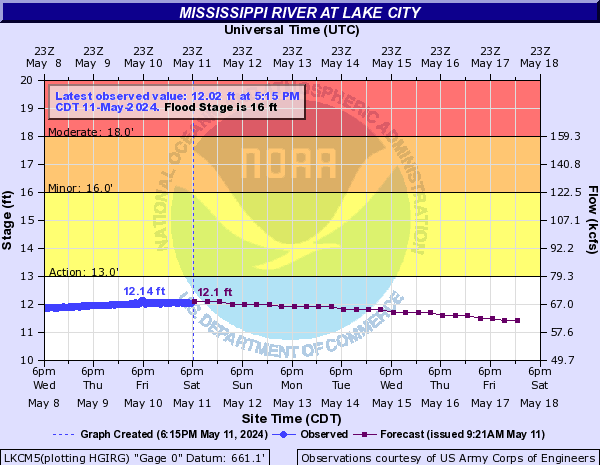
16
Minor lowland flooding occurs and some residential sections near the river are evacuated. Water and Sewer service is turned off along Central Point Road. In Wisconsin, structures on Barney's Point are inacessible due to inundated access route. Stockholm Village Park is flooded.
14
Central Point Road is closed.
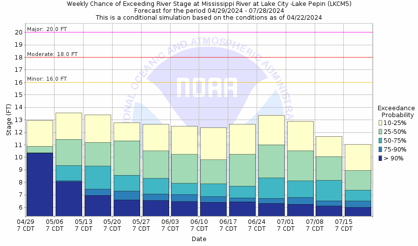
Flood Categories (in feet)
| Major Flood Stage: |
20 |
| Moderate Flood Stage: |
18 |
| Flood Stage: |
16 |
| Action Stage: |
13 |
| Low Stage (in feet): |
-9999 |
Historic Crests
(1) 22.18 ft on 04/19/1965
(2) 20.20 ft on 04/17/1969
(3) 20.13 ft on 04/16/2001
(4) 19.17 ft on 04/18/1952
(5) 19.06 ft on 04/16/1951
Show More Historic Crests
(P): Preliminary values subject to further review.
Recent Crests
(1) 18.98 ft on 04/25/2023
(P)
(2) 17.63 ft on 04/01/2019
(3) 16.43 ft on 06/30/2014
(4) 17.01 ft on 04/14/2011
(5) 14.48 ft on 09/29/2010
Show More Recent Crests
(P): Preliminary values subject to further review.