Flood ImpactsIf you notice any errors in the below information, please contact our Webmaster
19.3
Water reaches the top of the dike on the Wisconsin side of the river.
18
The road to the La Crosse Airport may experience flooding.
17.89
Water reaches the record flood level set in 1965.
17
Interstate 90 between Exit 3 and the Minnesota border may be closed.
16.5
Most of Riverside Park is flooded, with water up State Street in the Park about one block. Rose Street and Clinton Streets may need to be closed.
16
Water is within one foot of Rose Street near Interstate 90, and the eastbound I-90 exit may be closed. La Fond Street on French Island is closed. Water will encroach on Clinton Street. The shelter and ball parks in Copeland Park may be flooded.
15.4
Lock and Dam 7 becomes inoperative.
15
Flooding begins to impact the Viterbo Sports Complex.
14.5
Goose Island Park begins to flood. Water also begins to enter Lueth Park from the La Crosse River Marsh. Sewer service along Shore Acres Road shuts down.
14
Flooding begins to threaten homes in the Shore Acres area. Water begins to impact homes and businesses along La Fond Avenue and Bainbridge Street on French Island. Water begins to go over the road at Copeland Park with some water into the ball parks. Water is near the bottom of the Pettibone Beach shelter and water is nearly over the road at Houska Park near the wastewater treatment plant. Water also begins to spread into Riverside Park.
13.5
Water goes over the road in the 600 block of Shore Acres Road. Many La Crosse River Marsh trails are under water.
13
Portions of Goose Island County Park begin to flood.
12.3
Water begins to inundate Nelson Park in the Town of Campbell.
12
Pettibone Campground and RV Park is flooded. Road access to the north end of the Shore Acres development is impacted by flooding. Some lowland flooding occurs in other areas near the river.
10.5
Water begins to go over the Riverside Park boat mooring platform.
10
No wake rules for boating are in effect, and recreational trails on the north end of the marsh area are closed due to high water.
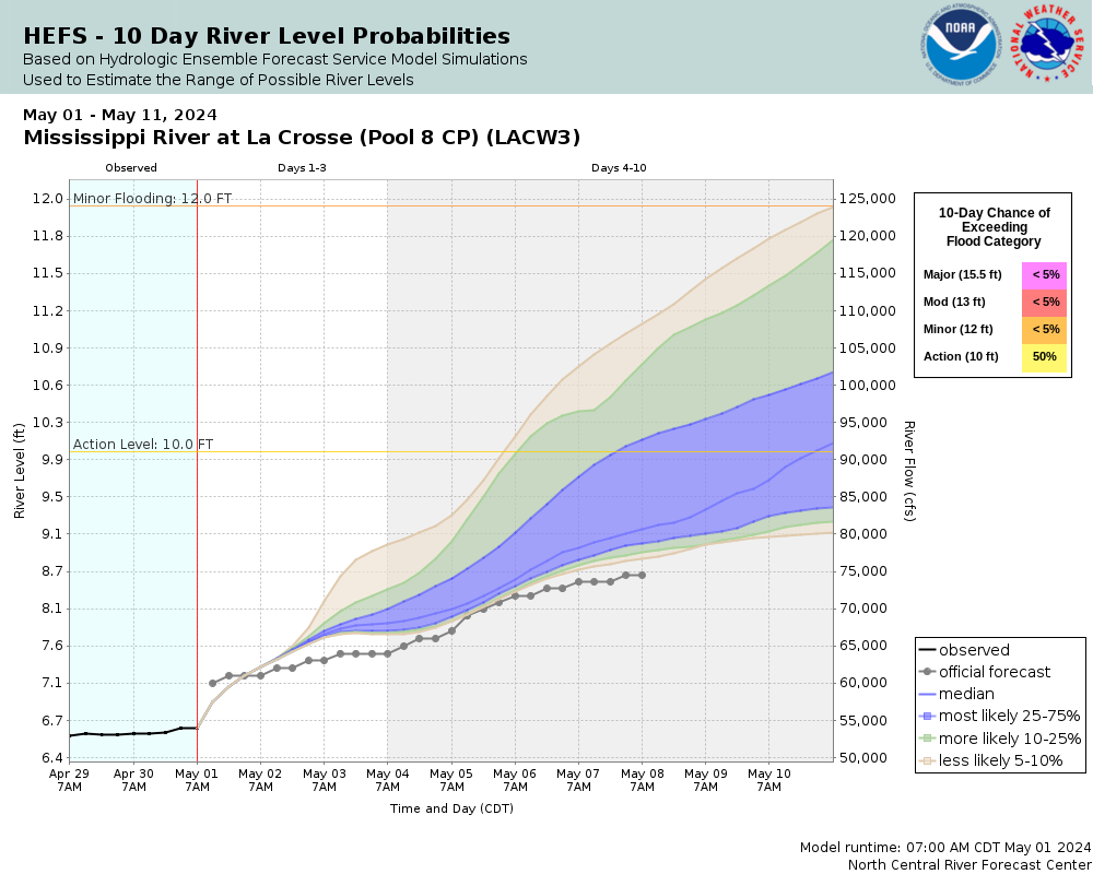
Flood Categories (in feet)
| Major Flood Stage: |
15.5 |
| Moderate Flood Stage: |
13 |
| Flood Stage: |
12 |
| Action Stage: |
10 |
| Low Stage (in feet): |
-9999 |
Historic Crests
(1) 17.89 ft on 04/22/1965
(2) 16.41 ft on 04/18/2001
(3) 15.89 ft on 04/26/2023
(P)
(4) 15.70 ft on 04/20/1969
(5) 15.30 ft on 04/20/1952
Show More Historic Crests
(P): Preliminary values subject to further review.
Recent Crests
(1) 15.89 ft on 04/26/2023
(P)
(2) 13.33 ft on 06/01/2019
(3) 14.33 ft on 04/24/2019
(4) 14.58 ft on 04/03/2019
(5) 12.17 ft on 06/25/2018
Show More Recent Crests
(P): Preliminary values subject to further review.