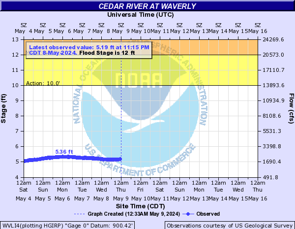
Cedar River At Waverly (WVLI4)
Return to TopFlood Stage: 12 Feet
Latest Stage: 4.97
Current Warnings/Statements/Advisories:None currently.
More information on datums is available at
www.ngs.noaa.gov/faq.shtml Flood Categories (in feet)
| Major Flood Stage: |
19 |
| Moderate Flood Stage: |
17 |
| Flood Stage: |
12 |
| Action Stage: |
10 |
| Low Stage (in feet): |
-9999 |
Historic Crests
(1) 19.33 ft on 06/10/2008
(2) 13.34 ft on 09/24/2016
(3) 13.16 ft on 09/18/2004
(4) 13.13 ft on 05/22/2013
(5) 12.95 ft on 04/14/2001
(6) 12.78 ft on 09/23/2016
(7) 11.53 ft on 08/30/2021
(8) 11.53 ft on 03/14/2010
(9) 10.49 ft on 03/17/2019
(10) 10.33 ft on 06/21/2014
Show More Historic Crests
(P): Preliminary values subject to further review.
Recent Crests
(1) 7.08 ft on 03/02/2023
(2) 5.83 ft on 04/15/2022
(3) 11.53 ft on 08/30/2021
(4) 7.66 ft on 03/11/2020
(5) 10.49 ft on 03/17/2019
(6) 9.59 ft on 09/22/2018
(7) 7.51 ft on 02/23/2017
(8) 13.34 ft on 09/24/2016
(9) 12.78 ft on 09/23/2016
(10) 8.43 ft on 06/25/2015
Show More Recent Crests
(P): Preliminary values subject to further review.
Low Water Records
Currently none available.
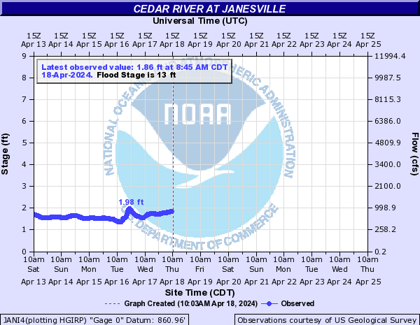
Cedar River At Janesville (JANI4)
Return to TopNOTE: River forecasts for this location take into account past precipitation and the precipitation amounts expected approximately 24 hours into the future from the forecast issuance time.
Flood Stage: 13 Feet
Latest Stage: 1.93
Current Warnings/Statements/Advisories:None currently.
More information on datums is available at
www.ngs.noaa.gov/faq.shtml Flood Categories (in feet)
| Major Flood Stage: |
18 |
| Moderate Flood Stage: |
15 |
| Flood Stage: |
13 |
| Action Stage: |
10 |
| Low Stage (in feet): |
-9999 |
Historic Crests
(1) 19.45 ft on 06/10/2008
(2) 17.15 ft on 07/22/1999
(3) 16.33 ft on 03/03/1965
(4) 16.33 ft on 03/28/1961
(5) 16.27 ft on 09/24/2016
(6) 16.20 ft on 03/17/1945
(7) 16.00 ft on 03/16/1929
(8) 16.00 ft on 04/01/1933
(9) 15.74 ft on 08/18/1993
(10) 15.11 ft on 08/30/2021
Show More Historic Crests
(P): Preliminary values subject to further review.
Recent Crests
(1) 8.57 ft on 05/17/2023
(2) 6.11 ft on 04/15/2022
(3) 15.11 ft on 08/30/2021
(4) 8.89 ft on 03/11/2020
(5) 12.40 ft on 03/18/2019
(6) 12.14 ft on 09/23/2018
(7) 9.24 ft on 10/29/2016
(8) 16.27 ft on 09/24/2016
(9) 9.89 ft on 06/25/2015
(10) 12.42 ft on 06/21/2014
Show More Recent Crests
(P): Preliminary values subject to further review.
Low Water Records
Currently none available.
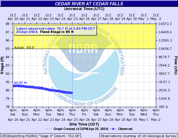
Cedar River At Cedar Falls (CEDI4)
Return to TopNOTE: River forecasts for this location take into account past precipitation and the precipitation amounts expected approximately 24 hours into the future from the forecast issuance time.
Flood Stage: 89 Feet
Latest Stage: 79.75
Current Warnings/Statements/Advisories:None currently.
More information on datums is available at
www.ngs.noaa.gov/faq.shtml Flood Categories (in feet)
| Major Flood Stage: |
94 |
| Moderate Flood Stage: |
92 |
| Flood Stage: |
89 |
| Action Stage: |
85 |
| Low Stage (in feet): |
-9999 |
Historic Crests
(1) 102.10 ft on 06/10/2008
(2) 98.90 ft on 09/24/2016
(3) 96.20 ft on 07/23/1999
(4) 96.10 ft on 03/21/1961
(5) 95.36 ft on 09/23/2018
(6) 95.05 ft on 03/17/2019
(7) 94.55 ft on 06/22/2014
(8) 93.85 ft on 05/31/2013
(9) 93.65 ft on 03/15/2010
(P)
(10) 91.84 ft on 03/25/2011
(P)
Show More Historic Crests
(P): Preliminary values subject to further review.
Recent Crests
(1) 90.13 ft on 03/02/2023
(2) 85.96 ft on 04/15/2022
(3) 91.43 ft on 08/31/2021
(4) 91.78 ft on 06/24/2020
(5) 95.05 ft on 03/17/2019
(6) 95.36 ft on 09/23/2018
(7) 89.90 ft on 02/24/2017
(8) 98.90 ft on 09/24/2016
(9) 89.43 ft on 06/26/2015
(10) 94.55 ft on 06/22/2014
Show More Recent Crests
(P): Preliminary values subject to further review.
Low Water Records
Currently none available.
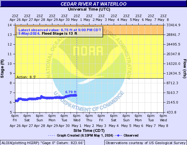
Cedar River At Waterloo (ALOI4)
Return to TopNOTE: River forecasts for this location take into account past precipitation and the precipitation amounts expected approximately 24 hours into the future from the forecast issuance time.
Flood Stage: 13 Feet
Latest Stage: 6.3
Current Warnings/Statements/Advisories:None currently.
More information on datums is available at
www.ngs.noaa.gov/faq.shtml Flood Categories (in feet)
| Major Flood Stage: |
21 |
| Moderate Flood Stage: |
19 |
| Flood Stage: |
13 |
| Action Stage: |
8.5 |
| Low Stage (in feet): |
-9999 |
Historic Crests
(1) 27.01 ft on 06/11/2008
(2) 22.95 ft on 09/24/2016
(3) 21.86 ft on 03/29/1961
(4) 21.67 ft on 04/08/1965
(5) 20.78 ft on 07/23/1999
(6) 20.60 ft on 04/02/1993
(7) 20.15 ft on 06/29/1969
(8) 20.00 ft on 03/16/1929
(9) 19.50 ft on 04/02/1933
(10) 19.32 ft on 05/25/2004
Show More Historic Crests
(P): Preliminary values subject to further review.
Recent Crests
(1) 11.64 ft on 03/02/2023
(2) 9.14 ft on 06/18/2022
(3) 12.47 ft on 08/31/2021
(4) 14.54 ft on 06/24/2020
(5) 18.83 ft on 03/17/2019
(6) 18.96 ft on 09/23/2018
(7) 11.74 ft on 10/01/2016
(8) 22.95 ft on 09/24/2016
(9) 11.13 ft on 06/26/2015
(10) 18.39 ft on 06/22/2014
Show More Recent Crests
(P): Preliminary values subject to further review.
Low Water Records
Currently none available.
Black Hawk Creek (Northeast IA) At Hudson (HUDI4)
Return to TopNOTE: River forecasts for this location take into account past precipitation and the precipitation amounts expected approximately 24 hours into the future from the forecast issuance time.
Flood Stage: 14 Feet
Latest Stage: 5.32
Current Warnings/Statements/Advisories:None currently.
More information on datums is available at
www.ngs.noaa.gov/faq.shtml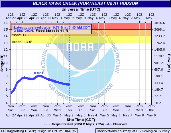
Flood Categories (in feet)
| Major Flood Stage: |
19 |
| Moderate Flood Stage: |
15 |
| Flood Stage: |
14 |
| Action Stage: |
13 |
| Low Stage (in feet): |
-9999 |
Historic Crests
(1) 19.03 ft on 04/25/2008
(2) 18.96 ft on 05/30/2013
(3) 18.50 ft on 07/01/2014
(4) 18.23 ft on 07/09/1969
(5) 18.12 ft on 06/23/2020
(6) 17.43 ft on 03/15/2019
(7) 17.32 ft on 06/17/1990
(8) 16.94 ft on 07/09/1993
(9) 16.93 ft on 03/31/1960
(10) 16.84 ft on 06/22/1974
Show More Historic Crests
(P): Preliminary values subject to further review.
Recent Crests
(1) 12.77 ft on 02/28/2023
(2) 13.47 ft on 02/16/2023
(3) 11.81 ft on 07/10/2022
(4) 10.54 ft on 03/08/2021
(5) 18.12 ft on 06/23/2020
(6) 17.43 ft on 03/15/2019
(7) 16.82 ft on 09/05/2018
(8) 14.63 ft on 01/21/2017
(9) 16.82 ft on 12/15/2015
(10) 14.92 ft on 08/30/2015
Show More Recent Crests
(P): Preliminary values subject to further review.
Low Water Records
Currently none available.
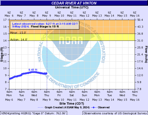
Cedar River At Vinton (VINI4)
Return to TopNOTE: River forecasts for this location take into account past precipitation and the precipitation amounts expected approximately 24 hours into the future from the forecast issuance time.
Flood Stage: 15 Feet
Latest Stage: 4.18
Current Warnings/Statements/Advisories:None currently.
Flood Categories (in feet)
| Major Flood Stage: |
19 |
| Moderate Flood Stage: |
18 |
| Flood Stage: |
15 |
| Action Stage: |
14 |
| Low Stage (in feet): |
-9999 |
Historic Crests
(1) 24.70 ft on 06/12/2008
(2) 21.80 ft on 09/26/2016
(3) 19.30 ft on 03/30/1961
(4) 19.20 ft on 04/04/1993
(5) 18.59 ft on 06/01/2013
(6) 18.40 ft on 05/26/2004
(7) 18.05 ft on 04/09/1965
(8) 18.00 ft on 07/24/1999
(9) 17.81 ft on 06/23/2014
(10) 17.72 ft on 03/17/2019
(P)
Show More Historic Crests
(P): Preliminary values subject to further review.
Recent Crests
(1) 15.97 ft on 06/25/2020
(P)
(2) 17.72 ft on 03/17/2019
(P)
(3) 21.80 ft on 09/26/2016
(4) 12.37 ft on 06/27/2015
(5) 17.81 ft on 06/23/2014
(6) 18.59 ft on 06/01/2013
(7) 8.28 ft on 05/09/2012
(8) 13.44 ft on 03/27/2011
(9) 15.95 ft on 03/16/2010
(10) 24.70 ft on 06/12/2008
Show More Recent Crests
(P): Preliminary values subject to further review.
Low Water Records
Currently none available.
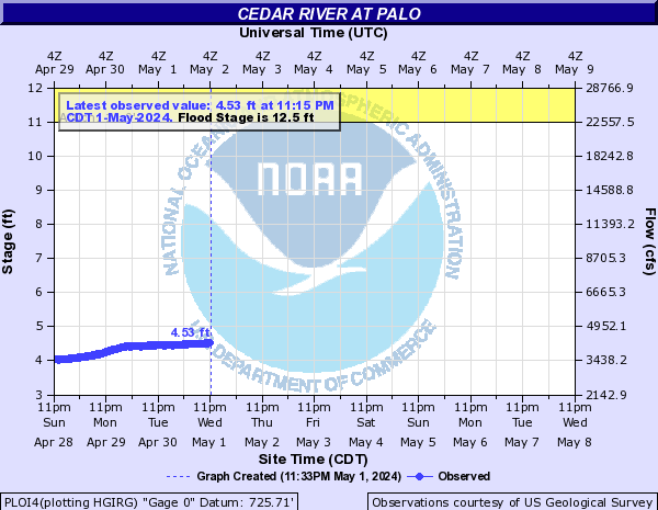
Cedar River At Palo (PLOI4)
Return to TopNOTE: River forecasts for this location take into account past precipitation and the precipitation amounts expected approximately 24 hours into the future from the forecast issuance time.
Flood Stage: 12.5 Feet
Latest Stage: 4.21
Current Warnings/Statements/Advisories:None currently.
Flood Categories (in feet)
| Major Flood Stage: |
17 |
| Moderate Flood Stage: |
15.5 |
| Flood Stage: |
12.5 |
| Action Stage: |
11 |
| Low Stage (in feet): |
-9999 |
Historic Crests
(1) 23.22 ft on 06/13/2008
(2) 18.07 ft on 09/27/2016
(3) 15.67 ft on 06/01/2013
(4) 15.38 ft on 03/18/2019
(P)
(5) 15.00 ft on 06/24/2014
(6) 14.18 ft on 03/17/2010
(7) 13.99 ft on 06/25/2020
(P)
(8) 12.37 ft on 03/28/2011
(9) 11.49 ft on 06/28/2015
(10) 11.35 ft on 01/25/2017
Show More Historic Crests
(P): Preliminary values subject to further review.
Recent Crests
(1) 13.99 ft on 06/25/2020
(P)
(2) 15.38 ft on 03/18/2019
(P)
(3) 11.35 ft on 01/25/2017
(4) 18.07 ft on 09/27/2016
(5) 11.49 ft on 06/28/2015
(6) 15.00 ft on 06/24/2014
(7) 15.67 ft on 06/01/2013
(8) 7.60 ft on 05/10/2012
(9) 12.37 ft on 03/28/2011
(10) 14.18 ft on 03/17/2010
Show More Recent Crests
(P): Preliminary values subject to further review.
Low Water Records
Currently none available.
Cedar River At Cedar Rapids (CIDI4)
Return to TopNOTE: River forecasts for this location take into account past precipitation and the precipitation amounts expected approximately 24 hours into the future from the forecast issuance time.
Flood Stage: 12 Feet
Latest Stage: 4.43
Current Warnings/Statements/Advisories:None currently.
Flood Categories (in feet)
| Major Flood Stage: |
16 |
| Moderate Flood Stage: |
14 |
| Flood Stage: |
12 |
| Action Stage: |
10 |
| Low Stage (in feet): |
-9999 |
Historic Crests
(1) 31.12 ft on 06/13/2008
(2) 21.97 ft on 09/27/2016
(3) 20.00 ft on 06/01/1851
(4) 20.00 ft on 03/18/1929
(5) 19.66 ft on 03/31/1961
(6) 19.27 ft on 04/04/1993
(7) 18.60 ft on 04/04/1933
(8) 18.51 ft on 04/10/1965
(9) 18.32 ft on 03/19/2019
(10) 18.31 ft on 07/25/1999
Show More Historic Crests
(P): Preliminary values subject to further review.
Recent Crests
(1) 15.71 ft on 06/25/2020
(2) 18.32 ft on 03/19/2019
(3) 17.94 ft on 09/26/2018
(4) 10.09 ft on 02/02/2017
(5) 13.98 ft on 10/01/2016
(6) 21.97 ft on 09/27/2016
(7) 10.30 ft on 06/28/2015
(8) 16.77 ft on 06/24/2014
(9) 15.00 ft on 06/28/2013
(10) 18.23 ft on 06/02/2013
Show More Recent Crests
(P): Preliminary values subject to further review.
Low Water Records
Currently none available.
Cedar River Near Conesville (CNEI4)
Return to TopNOTE: River forecasts for this location take into account past precipitation and the precipitation amounts expected approximately 24 hours into the future from the forecast issuance time.
Flood Stage: 13 Feet
Latest Stage: 7.65
Current Warnings/Statements/Advisories:None currently.
Flood Categories (in feet)
| Major Flood Stage: |
16.5 |
| Moderate Flood Stage: |
15 |
| Flood Stage: |
13 |
| Action Stage: |
12 |
| Low Stage (in feet): |
-9999 |
Historic Crests
(1) 23.40 ft on 06/15/2008
(2) 18.06 ft on 09/29/2016
(3) 17.88 ft on 07/02/2014
(4) 17.38 ft on 10/01/2016
(5) 17.11 ft on 04/06/1993
(6) 17.00 ft on 05/29/2004
(7) 16.90 ft on 06/03/2013
(8) 16.87 ft on 06/18/1990
(9) 16.85 ft on 04/12/1965
(10) 16.80 ft on 07/28/1999
Show More Historic Crests
(P): Preliminary values subject to further review.
Recent Crests
(1) 13.36 ft on 03/06/2023
(P)
(2) 15.84 ft on 06/27/2020
(3) 16.04 ft on 05/31/2019
(4) 16.31 ft on 03/20/2019
(5) 16.41 ft on 09/28/2018
(6) 17.38 ft on 10/01/2016
(7) 18.06 ft on 09/29/2016
(8) 13.51 ft on 06/30/2015
(9) 17.88 ft on 07/02/2014
(10) 16.90 ft on 06/03/2013
Show More Recent Crests
(P): Preliminary values subject to further review.
Low Water Records
Currently none available.
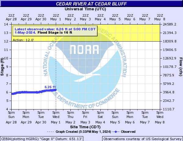
Cedar River At Cedar Bluff (CEBI4)
Return to TopNOTE: River forecasts for this location take into account past precipitation and the precipitation amounts expected approximately 24 hours into the future from the forecast issuance time.
Flood Stage: 16 Feet
Latest Stage: 6.25
Current Warnings/Statements/Advisories:None currently.
Flood Categories (in feet)
| Major Flood Stage: |
26 |
| Moderate Flood Stage: |
20 |
| Flood Stage: |
16 |
| Action Stage: |
12 |
| Low Stage (in feet): |
-9999 |
Historic Crests
(1) 24.70 ft on 09/28/2016
(2) 21.99 ft on 06/02/2013
(3) 21.47 ft on 03/19/2019
(4) 21.38 ft on 09/26/2018
(5) 20.83 ft on 07/02/2014
(6) 19.75 ft on 10/01/2016
(7) 19.00 ft on 06/26/2020
(8) 13.64 ft on 06/29/2015
(P): Preliminary values subject to further review.
Recent Crests
(1) 19.00 ft on 06/26/2020
(2) 21.47 ft on 03/19/2019
(3) 21.38 ft on 09/26/2018
(4) 19.75 ft on 10/01/2016
(5) 24.70 ft on 09/28/2016
(6) 13.64 ft on 06/29/2015
(7) 20.83 ft on 07/02/2014
(8) 21.99 ft on 06/02/2013
(P): Preliminary values subject to further review.
Low Water Records
Currently none available.