Flood ImpactsIf you notice any errors in the below information, please contact our Webmaster
57.3
Top of the permanent levee project at Pembina.
53.6
MN 171 bridge approaches flood (MN DOT).
53
May need to evacuate South Pembina.
52
Highway 75 north of Humboldt, MN overtops.
50
South end of Airport Road closes.
49
MAJOR FLOOD.
48.8
Highway 75 dike installed at Noyes, MN.
48
City dike patrol begins.
46.6
MN 175 bridge (south of Pembina and north of Drayton) approaches flood (MN DOT).
46
General rural flooding.
45
Urban damage to Saint Vincent.
44
MODERATE FLOOD.
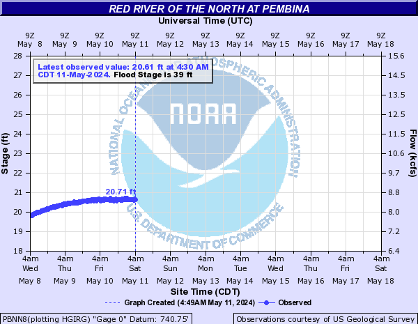
39
MINOR FLOOD.
35
ACTION STAGE/FORECAST SERVICE STAGE.
29
Floodgate at main pumphouse is closed.
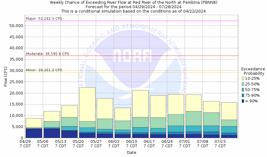
Flood Categories (in feet)
| Major Flood Stage: |
49 |
| Moderate Flood Stage: |
44 |
| Flood Stage: |
39 |
| Action Stage: |
35 |
| Low Stage (in feet): |
-9999 |
Historic Crests
(1) 54.94 ft on 04/26/1997
(2) 52.71 ft on 04/15/2009
(3) 52.31 ft on 05/07/2022
Show More Historic Crests
(P): Preliminary values subject to further review.
Recent Crests
(1) 52.31 ft on 05/07/2022
(2) 21.95 ft on 03/24/2021
(3) 50.57 ft on 04/19/2020
Show More Recent Crests
(P): Preliminary values subject to further review.
Low Water Records
Currently none available.