Flood ImpactsIf you notice any errors in the below information, please contact our Webmaster
44
Top elevation of the dike at Halstad.
42
Approach to I-29 bridge under water on North Dakota side of the Red River.
38
US Highway 75 closure installed on the south side of the Halstad ring dike.
37.5
MAJOR FLOOD.
37
US Highway 75 is flooded outside of the Halstad ring dike north and south of the city.
36.4
City mobilizes for dike patrols.
33
Considerable rural and farmland flooding.
32
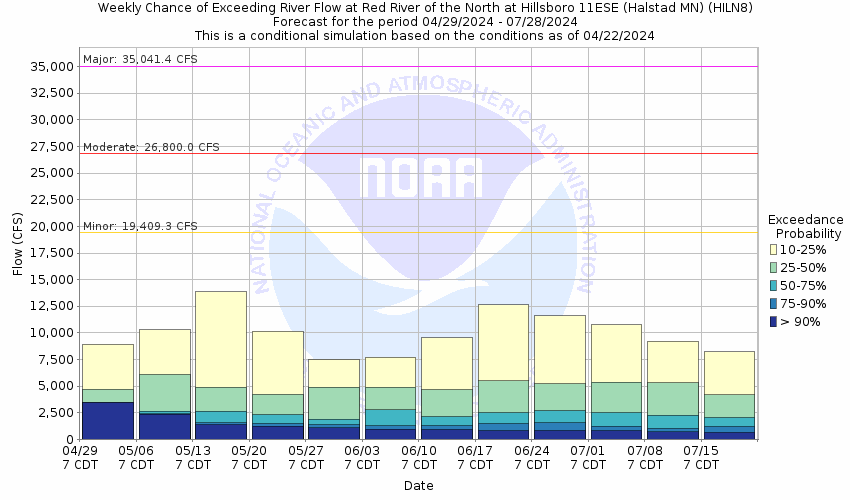
MODERATE FLOOD.
30.8
Approach to I-29 bridge impassable.
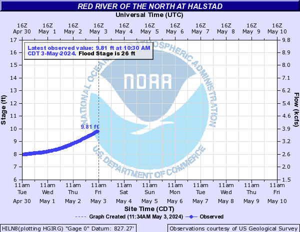
26
MINOR FLOOD.
24
ACTION STAGE/FORECAST SERVICE STAGE.
Flood Categories (in feet)
| Major Flood Stage: |
37.5 |
| Moderate Flood Stage: |
32 |
| Flood Stage: |
26 |
| Action Stage: |
24 |
| Low Stage (in feet): |
-9999 |
Historic Crests
(1) 40.74 ft on 04/19/1997
(2) 40.63 ft on 03/30/2009
(3) 40.51 ft on 04/12/2011
Show More Historic Crests
(P): Preliminary values subject to further review.
Recent Crests
(1) 31.83 ft on 05/02/2022
(2) 12.20 ft on 03/14/2021
(3) 37.40 ft on 04/09/2020
Show More Recent Crests
(P): Preliminary values subject to further review.
Low Water Records
(1) 9.80 ft on 09/02/1976