Flood ImpactsIf you notice any errors in the below information, please contact our Webmaster
15
Several evacuations and road closures may occur.
14.5
Water affects residences along West 1st Street north and south of Iowa 9...and along Valley Drive.
14
Sandbagging may be needed on the W side of Estherville.
13
Backwater from the river causes School Creek to flood Valley Drive. Burr Oak Road...and some other secondary roads in rural Emmet County may be closed.
12.5
Water affects West 1st Street north and south of Iowa 9. Some residences just south of Estherville flood.
12
Water affects the low areas of West 1st Street south of Iowa 9. Residences on Valley Drive along School Creek are affected.
11
Mike Mickelson Park South of Iowa 9 is inundated.
10
There is extensive lowland flooding particularly over the parkland areas near the river.
7
Mike Mickelson Park South of Iowa 9 floods. North Riverside Park North of Iowa 9 floods. Backwater from the river causes School Creek to affect the low areas of Valley Drive.
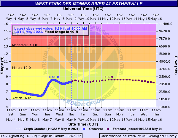
Flood Categories (in feet)
| Major Flood Stage: |
14.5 |
| Moderate Flood Stage: |
13 |
| Flood Stage: |
10 |
| Action Stage: |
8 |
| Low Stage (in feet): |
-9999 |
Historic Crests
(1) 17.68 ft on 04/12/1969
(2) 15.61 ft on 04/10/1965
(3) 15.53 ft on 06/08/1953
(4) 15.38 ft on 06/30/1993
(5) 15.24 ft on 03/25/2019
(6) 14.89 ft on 07/09/2018
(7) 14.30 ft on 04/14/1984
(8) 12.66 ft on 07/06/1983
(9) 12.22 ft on 04/06/1962
(10) 12.03 ft on 03/25/1961
Show More Historic Crests
(P): Preliminary values subject to further review.
Recent Crests
(1) 9.04 ft on 04/21/2023
(2) 7.84 ft on 06/15/2022
(3) 15.24 ft on 03/25/2019
(4) 14.89 ft on 07/09/2018
(5) 8.01 ft on 05/23/2017
(6) 9.95 ft on 06/19/1994
(7) 10.10 ft on 03/06/1994
(8) 15.38 ft on 06/30/1993
(9) 8.59 ft on 03/07/1992
(10) 11.11 ft on 06/11/1991
Show More Recent Crests
(P): Preliminary values subject to further review.
Low Water Records
Currently none available.