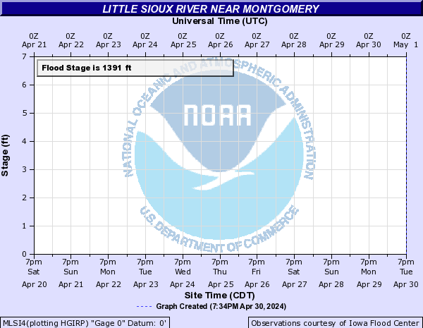
Little Sioux River Near Montgomery (MLSI4)
Return to TopNOTE: No forecasts are available for this location
Flood Stage: 0 KCFS
Latest Flow: n/a
Current Warnings/Statements/Advisories:None currently.
Flood ImpactsIf you notice any errors in the below information, please contact our Webmaster
1397
the bridge on 140th Street west of Montgomery is overtopped.
1396.5
140th Street west of Montgomery begins to flood as does 130th west of the bridge at the gage.
1395
190th Avenue south of the MN/IA State Line begins to flood, and the bridge on 170th Avenue north of Highway 9 is overtopped. Water also reaches the bottom of the bridge on 140th Street west of Montgomery.
1394.5
Highway 9 east of the Little Sioux River bridge is flooded in two lower spots.
1393
water begins to flood 190th Avenue north of 120th st.
1391.5
170th Avenue north of Highway 9 begins to flood.
1391
crop and pasture land begin to flood.
Flood Categories (in feet)
| Major Flood Stage: |
1394.5 |
| Moderate Flood Stage: |
1393 |
| Flood Stage: |
1391 |
| Action Stage: |
1390 |
| Low Stage (in feet): |
-9999 |
Historic Crests
(1) 1,394.90 ft on 06/24/2018
(2) 1,394.32 ft on 03/16/2019
(3) 1,391.43 ft on 03/07/2020
(4) 1,390.13 ft on 04/15/2018
(5) 1,389.92 ft on 03/26/2023
(P): Preliminary values subject to further review.
Recent Crests
(1) 1,389.92 ft on 03/26/2023
(2) 1,391.43 ft on 03/07/2020
(3) 1,394.32 ft on 03/16/2019
(4) 1,394.90 ft on 06/24/2018
(5) 1,390.13 ft on 04/15/2018
(P): Preliminary values subject to further review.
Low Water Records
Currently none available.
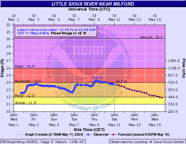
Little Sioux River Near Milford (MIFI4)
Return to TopNOTE: River forecasts for this location take into account past precipitation and the precipitation amounts expected approximately 48 hours into the future from the forecast issuance time.
Flood Stage: 12 Feet
Latest Stage: 9.51
Current Warnings/Statements/Advisories:None currently.
Flood ImpactsIf you notice any errors in the below information, please contact our Webmaster
18.5
190th Avenue begins flooding near Horseshoe Bend county park.
17.5
water reaches the road on 190th Avenue near 240th Street.
16
170th Avenue south of Highway 9 is flooded.
15.5
the bridge on 190th Avenue near 240th Street is overtopped, and 180th Street between 170th Avenue and 190th Avenue is flooded.
14
significant amounts of pasture and other farm lands begin to flood.
12
minor flooding of low lying agricultural lands begins.
Flood Categories (in feet)
| Major Flood Stage: |
16 |
| Moderate Flood Stage: |
14 |
| Flood Stage: |
12 |
| Action Stage: |
11 |
| Low Stage (in feet): |
-9999 |
Historic Crests
(1) 20.10 ft on 06/25/2018
(2) 18.02 ft on 03/18/2019
(3) 17.50 ft on 07/15/2011
(4) 17.37 ft on 06/19/2014
(5) 16.84 ft on 08/23/2007
Show More Historic Crests
(P): Preliminary values subject to further review.
Recent Crests
(1) 13.59 ft on 04/05/2023
(2) 15.19 ft on 03/09/2020
(3) 18.02 ft on 03/18/2019
(4) 20.10 ft on 06/25/2018
(5) 12.50 ft on 05/24/2017
Show More Recent Crests
(P): Preliminary values subject to further review.
Low Water Records
Currently none available.
Little Sioux River Above Spencer (LSSI4)
Return to TopNOTE: River forecasts for this location take into account past precipitation and the precipitation amounts expected approximately 48 hours into the future from the forecast issuance time.
Flood Stage: 0 KCFS
Latest Flow: n/a
Current Warnings/Statements/Advisories:None currently.
Flood ImpactsIf you notice any errors in the below information, please contact our Webmaster
21
300th Street east of the gage begins flooding.
20
190th Avenue just north of Highway 18 begins flooding.
18
water reaches the bottom of the bridge on 300th Street at the gage.
15
290th Street north of the gage begins flooding as well as 180th Avenue southeast of the gage.
13
major agricultural flooding begins.
10
minor flooding of agricultural lands begins.
Flood Categories (in feet)
| Major Flood Stage: |
15 |
| Moderate Flood Stage: |
13 |
| Flood Stage: |
10 |
| Action Stage: |
9 |
| Low Stage (in feet): |
-9999 |
Historic Crests
(1) 14.45 ft on 07/15/2011
(2) 13.49 ft on 06/20/2014
(3) 13.20 ft on 03/18/2010
(4) 10.99 ft on 03/10/2013
(5) 9.95 ft on 06/01/2012
(P): Preliminary values subject to further review.
Recent Crests
(1) 13.49 ft on 06/20/2014
(2) 10.99 ft on 03/10/2013
(3) 9.95 ft on 06/01/2012
(4) 14.45 ft on 07/15/2011
(5) 13.20 ft on 03/18/2010
(P): Preliminary values subject to further review.
Low Water Records
Currently none available.
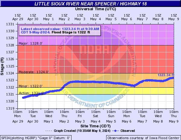
Little Sioux River Near Spencer / Highway 18 (SPII4)
Return to TopNOTE: No forecasts are available for this location
Flood Stage: 1322 Feet
Latest Stage: 1318.54
Current Warnings/Statements/Advisories:None currently.
Flood ImpactsIf you notice any errors in the below information, please contact our Webmaster
1347.5
water reaches the bottom of the Highway 18 bridge.
Flood Categories (in feet)
| Major Flood Stage: |
1328 |
| Moderate Flood Stage: |
1324 |
| Flood Stage: |
1322 |
| Action Stage: |
1321 |
| Low Stage (in feet): |
-9999 |
Historic Crests
(1) 1,326.60 ft on 06/25/2018
(2) 1,325.50 ft on 03/18/2019
(3) 1,323.44 ft on 03/10/2020
(4) 1,322.59 ft on 05/15/2023
(P): Preliminary values subject to further review.
Recent Crests
(1) 1,322.59 ft on 05/15/2023
(2) 1,323.44 ft on 03/10/2020
(3) 1,325.50 ft on 03/18/2019
(4) 1,326.60 ft on 06/25/2018
(P): Preliminary values subject to further review.
Low Water Records
Currently none available.
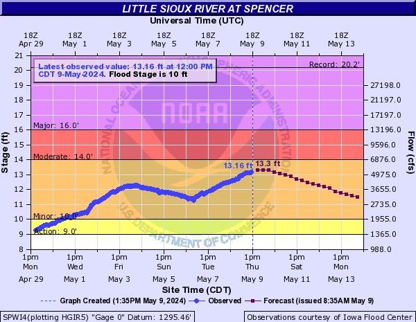
Little Sioux River At Spencer (SPWI4)
Return to TopNOTE: River forecasts for this location take into account past precipitation and the precipitation amounts expected approximately 48 hours into the future from the forecast issuance time.
Flood Stage: 10 Feet
Latest Stage: 6.96
Current Warnings/Statements/Advisories:None currently.
Flood ImpactsIf you notice any errors in the below information, please contact our Webmaster
21
the levees in Spencer are overtopped, and Park Street and Grand Avenue in Spencer are flooded.
19.5
flooding begins to affect the Breezy Meadows Addition in Spencer, and most of the city south of the river is flooded.
18
the Spencer Golf and Country Club begins flooding.
16.5
Highway 71 and Highway 18 begin to flood, and West Park Street, 1st Street, and 2nd Street in Spencer are flooded. Some homes and businesses in the southern portions of Spencer are also flooded.
16
Highway 18 near Hawk Valley WMA east of Spencer beings flooding.
14.5
County Road B40 southeast of Spencer begins flooding.
14
city sewers in Spencer can begin to back up. Highway 18 between Spencer and Dickens can start flooding if flows on the tributary creeks are also very high.
10
the right bank overflows, and minor flooding of the Spencer city park and some rural agricultural areas begins.
9.5
the lower left bank overflows and very minor flooding of low lands begins.
Flood Categories (in feet)
| Major Flood Stage: |
16 |
| Moderate Flood Stage: |
14 |
| Flood Stage: |
10 |
| Action Stage: |
9 |
| Low Stage (in feet): |
-9999 |
Historic Crests
(1) 20.20 ft on 06/08/1953
(2) 17.60 ft on 06/21/1954
(3) 17.45 ft on 03/15/2019
(4) 17.40 ft on 06/26/2018
(5) 17.37 ft on 04/06/1965
Show More Historic Crests
(P): Preliminary values subject to further review.
Recent Crests
(1) 10.89 ft on 05/16/2023
(2) 11.70 ft on 03/10/2020
(3) 17.45 ft on 03/15/2019
(4) 17.40 ft on 06/26/2018
(5) 12.20 ft on 05/23/2017
Show More Recent Crests
(P): Preliminary values subject to further review.
Low Water Records
Currently none available.
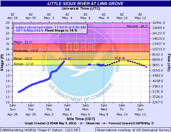
Little Sioux River At Linn Grove (LNNI4)
Return to TopNOTE: River forecasts for this location take into account past precipitation and the precipitation amounts expected approximately 48 hours into the future from the forecast issuance time.
Flood Stage: 18 Feet
Latest Stage: 10.33
Current Warnings/Statements/Advisories:None currently.
Flood ImpactsIf you notice any errors in the below information, please contact our Webmaster
20
significant flooding of agricultural land begins along this entire stretch of the river.
18.5
the city park in Sioux Rapids is flooded.
18
flooding begins to affect agricultural land.
Flood Categories (in feet)
| Major Flood Stage: |
21 |
| Moderate Flood Stage: |
19.5 |
| Flood Stage: |
18 |
| Action Stage: |
17 |
| Low Stage (in feet): |
-9999 |
Historic Crests
(1) 24.13 ft on 03/16/2019
(2) 23.91 ft on 09/22/2018
(3) 22.91 ft on 06/18/2014
(4) 22.85 ft on 03/17/2010
(5) 22.57 ft on 07/17/2011
Show More Historic Crests
(P): Preliminary values subject to further review.
Recent Crests
(1) 13.90 ft on 05/18/2023
(2) 7.76 ft on 03/09/2021
(3) 15.72 ft on 05/29/2020
(4) 24.13 ft on 03/16/2019
(5) 23.91 ft on 09/22/2018
Show More Recent Crests
(P): Preliminary values subject to further review.
Low Water Records
Currently none available.
Little Sioux River At Cherokee (CHKI4)
Return to TopNOTE: River forecasts for this location take into account past precipitation and the precipitation amounts expected approximately 48 hours into the future from the forecast issuance time.
Flood Stage: 17 Feet
Latest Stage: 11.34
Current Warnings/Statements/Advisories:None currently.

Flood ImpactsIf you notice any errors in the below information, please contact our Webmaster
29
water reaches the IFC sensor feed-horn
27
numerous homes and businesses are isolated or flooded in Cherokee, and Highway 59 south of Cherokee is flooded.
24
County Highway C38E is closed due to flooding, and the water reaches the northwest corner of 2nd Street and Beech Street in Cherokee. Water also reaches the front of the B&H feed store. County Road C44 between Highway 159 and County Road L56 is flooded.
23
some areas in the extreme southeast corner of Cherokee will begin to flood.
22.5
Highway 59 south of Cherokee begins to get water over the road.
22
East Main Street on the far east end of Cherokee begins flooding.
21
Old Highway 5 East begins to flood, and some homes, businesses, and roads in Cherokee begin flooding.
19
the north bank of the river overflows.
18
Cherokee city park begins to flood on the south bank of the river.
17
minor lowland flooding begins, and Cherokee County Rescue mobilizes and sets up the flood control center.
Flood Categories (in feet)
| Major Flood Stage: |
24 |
| Moderate Flood Stage: |
21 |
| Flood Stage: |
17 |
| Action Stage: |
15 |
| Low Stage (in feet): |
-9999 |
Historic Crests
(1) 28.40 ft on 03/14/2019
(2) 27.90 ft on 05/27/2013
(3) 27.30 ft on 06/27/2010
(4) 27.20 ft on 04/07/1965
(5) 27.08 ft on 07/18/1993
Show More Historic Crests
(P): Preliminary values subject to further review.
Recent Crests
(1) 12.71 ft on 05/18/2023
(2) 16.38 ft on 05/28/2020
(3) 28.40 ft on 03/14/2019
(4) 27.00 ft on 09/21/2018
(5) 19.83 ft on 05/04/2016
Show More Recent Crests
(P): Preliminary values subject to further review.
Low Water Records
Currently none available.
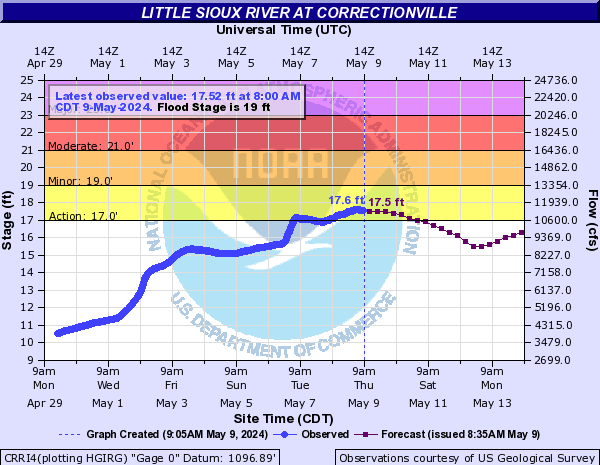
Little Sioux River At Correctionville (CRRI4)
Return to TopNOTE: River forecasts for this location take into account past precipitation and the precipitation amounts expected approximately 48 hours into the future from the forecast issuance time.
Flood Stage: 19 Feet
Latest Stage: 9.19
Current Warnings/Statements/Advisories:None currently.
Flood ImpactsIf you notice any errors in the below information, please contact our Webmaster
26
the bridge on County Road L36 northwest of Correctionville is overtopped.
23.8
major agricultural flooding on the east side of the river begins, and water will spread 1/4 mile east and affect highway L27.
23.5
the water reaches the bottom of the bridge on County Road L36 northwest of Correctionville, the southern portions of Correctionville will be significantly affected by flooding, and many sewers, homes, and roads will be flooded.
23
Iowa Highway 31 North begins flooding. If Bacon Creek between Correctionville and Cushing is also running high, water will begin backing up Bacon Creek and flood the southern portions of Correctionville along and north of County Road D22.
22.8
Iowa Highway 31 South will begin flooding.
22
some homes and businesses southwest of the gauging location will begin flooding.
19
significant amounts of agricultural land are flooded.
16
the lower left bank of the river overflows with minor flooding of some of the low lying agricultural lands.
Flood Categories (in feet)
| Major Flood Stage: |
23 |
| Moderate Flood Stage: |
21 |
| Flood Stage: |
19 |
| Action Stage: |
17 |
| Low Stage (in feet): |
-9999 |
Historic Crests
(1) 29.34 ft on 06/23/1891
(2) 26.45 ft on 03/15/2019
(3) 25.86 ft on 04/07/1965
(4) 25.35 ft on 05/28/2013
(5) 24.39 ft on 06/20/2014
Show More Historic Crests
(P): Preliminary values subject to further review.
Recent Crests
(1) 12.91 ft on 02/28/2023
(2) 13.64 ft on 05/28/2020
(3) 26.45 ft on 03/15/2019
(4) 24.30 ft on 09/24/2018
(5) 13.66 ft on 05/27/2017
Show More Recent Crests
(P): Preliminary values subject to further review.
Low Water Records
Currently none available.
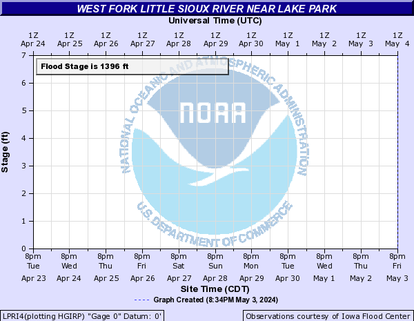
West Fork Little Sioux River Near Lake Park (LPRI4)
Return to TopNOTE: No forecasts are available for this location
Flood Stage: 0 KCFS
Latest Flow: n/a
Current Warnings/Statements/Advisories:None currently.
Flood ImpactsIf you notice any errors in the below information, please contact our Webmaster
1413.5
the Highway 9 bridge north of the gauge is overtopped.
1411
water reaches the bottom of the Highway 9 bridge north of the gauge.
1404
the bridge on 160th Avenue south of Highway 9 is overtopped.
1400
160th Avenue begins to flood south of Highway 9.
1398
significant amounts of crop and pasture land are flooded north of Highway 9, and 125th Street just east of the river northeast of Lake Park begins flooding.
1396
crop and pasture land begins to flood between Lake Park and Montgomery.
Flood Categories (in feet)
| Major Flood Stage: |
1400 |
| Moderate Flood Stage: |
1398 |
| Flood Stage: |
1396 |
| Action Stage: |
1395 |
| Low Stage (in feet): |
-9999 |
Historic Crests
(1) 1,399.40 ft on 06/24/2018
(2) 1,398.79 ft on 03/16/2019
(3) 1,395.90 ft on 03/16/2018
(4) 1,394.73 ft on 05/19/2020
(5) 1,394.68 ft on 04/04/2023
(P): Preliminary values subject to further review.
Recent Crests
(1) 1,394.68 ft on 04/04/2023
(2) 1,394.73 ft on 05/19/2020
(3) 1,398.79 ft on 03/16/2019
(4) 1,399.40 ft on 06/24/2018
(5) 1,395.90 ft on 03/16/2018
(P): Preliminary values subject to further review.
Low Water Records
Currently none available.
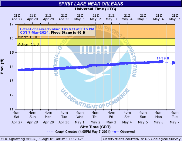
Spirit Lake Near Orleans (SLKI4)
Return to TopNOTE: No forecasts are available for this location
Flood Stage: 16 Feet
Latest Stage: 13.54
Current Warnings/Statements/Advisories:None currently.
Flood ImpactsIf you notice any errors in the below information, please contact our Webmaster
20
yards and basements of homes along the lake shore start flooding.
17
water overflows the spillway channel, and camping areas, parks, and parking lots start to flood.
16
the Emergency Lake-wide 5 mph rule on Big Spirit Lake is enacted.
14.2
water from Spirit Lake starts going over the spillway into East Okoboji Lake.
Flood Categories (in feet)
| Major Flood Stage: |
19 |
| Moderate Flood Stage: |
17 |
| Flood Stage: |
16 |
| Action Stage: |
15.5 |
| Low Stage (in feet): |
-9999 |
Historic Crests
(1) 18.79 ft on 07/18/1993
(2) 15.94 ft on 07/05/2018
(3) 15.76 ft on 04/12/1995
(4) 15.72 ft on 07/10/1969
(5) 15.68 ft on 03/31/2007
Show More Historic Crests
(P): Preliminary values subject to further review.
Recent Crests
(1) 14.70 ft on 05/14/2023
(2) 15.03 ft on 04/01/2020
(3) 15.58 ft on 03/26/2019
(4) 15.94 ft on 07/05/2018
(5) 15.05 ft on 05/24/2017
Show More Recent Crests
(P): Preliminary values subject to further review.
Low Water Records
Currently none available.
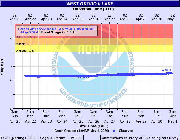
Milford Creek Near Milford (OBJI4)
Return to TopNOTE: No forecasts are available for this location
Flood Stage: 6.5 Feet
Latest Stage: 4.29
Current Warnings/Statements/Advisories:None currently.
Flood ImpactsIf you notice any errors in the below information, please contact our Webmaster
10
county roads along Milford Creek start flooding, and the pumping station near the Lower Gar Lake outlet begins flooding.
8.5
water is over the top of the culvert at the county road crossing the Lower Gar Lake outlet, and moderate flooding of pasture land along Milford Creek begins.
7.5
flooding of low lands along Milford Creek begins.
6.75
water reaches the floor of the pump house for water supply for Milford and West Okoboji.
6.2
the Emergency Lake-wide 5 mph rule on East Okoboji, West Okoboji, Upper Gar, Lower Gar, and Minnewashta lakes is enacted.
Flood Categories (in feet)
| Major Flood Stage: |
9 |
| Moderate Flood Stage: |
7 |
| Flood Stage: |
6.5 |
| Action Stage: |
6 |
| Low Stage (in feet): |
-9999 |
Historic Crests
(1) 8.66 ft on 07/17/1993
(2) 6.60 ft on 07/05/2018
(3) 6.25 ft on 07/16/2011
(4) 6.23 ft on 06/24/1984
(5) 6.14 ft on 07/08/1962
Show More Historic Crests
(P): Preliminary values subject to further review.
Recent Crests
(1) 4.69 ft on 05/15/2023
(2) 5.24 ft on 06/05/2020
(3) 5.98 ft on 05/31/2019
(4) 6.60 ft on 07/05/2018
(5) 5.15 ft on 05/27/2017
Show More Recent Crests
(P): Preliminary values subject to further review.
Low Water Records
Currently none available.
Milford Creek At Lower Gar Lake Outlet (LGLI4)
Return to TopNOTE: No forecasts are available for this location
Flood Stage: 0 KCFS
Latest Flow: n/a
Current Warnings/Statements/Advisories:None currently.
Flood ImpactsIf you notice any errors in the below information, please contact our Webmaster
9.5
County roads along Milford Creek start flooding, and the pumping station near the Lower Gar Lake outlet begins flooding. Homes along Lower Gar Lake will also begin flooding.
8
Water overtops the culverts leading out of Lower Gar Lake and floods the road.
6
Flooding of pasture lands along Milford Creek begins, and water reaches the bottom of the culverts at the outlet of Lower Gar Lake. Boat docks on Lower Gar Lake will also begin to flood.
Flood Categories (in feet)
| Major Flood Stage: |
9.5 |
| Moderate Flood Stage: |
8 |
| Flood Stage: |
6 |
| Action Stage: |
5 |
| Low Stage (in feet): |
-9999 |
Historic Crests
(1) 3.19 ft on 05/15/2018
(P): Preliminary values subject to further review.
Recent Crests
(1) 3.19 ft on 05/15/2018
(P): Preliminary values subject to further review.
Low Water Records
Currently none available.
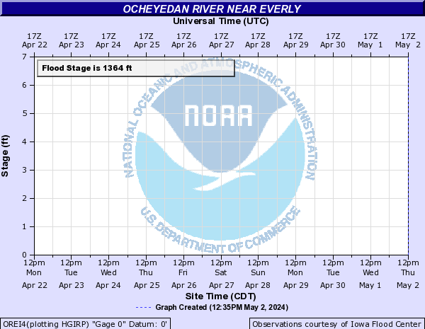
Ocheyedan River Near Everly (OREI4)
Return to TopNOTE: No forecasts are available for this location
Flood Stage: 0 KCFS
Latest Flow: n/a
Current Warnings/Statements/Advisories:None currently.
Flood ImpactsIf you notice any errors in the below information, please contact our Webmaster
1370
Highway 18 will begin to flood.
1366
significant flooding of crop and pasture land begins.
1364
ditches fill, the lowest banks overflow, and minor flooding of agricultural land begins.
Flood Categories (in feet)
| Major Flood Stage: |
1370 |
| Moderate Flood Stage: |
1366 |
| Flood Stage: |
1364 |
| Action Stage: |
1362 |
| Low Stage (in feet): |
-9999 |
Historic Crests
(1) 1,366.88 ft on 03/14/2019
(2) 1,366.47 ft on 06/22/2018
(3) 1,360.68 ft on 05/18/2020
(4) 1,359.90 ft on 04/03/2023
(P): Preliminary values subject to further review.
Recent Crests
(1) 1,359.90 ft on 04/03/2023
(2) 1,360.68 ft on 05/18/2020
(3) 1,366.88 ft on 03/14/2019
(4) 1,366.47 ft on 06/22/2018
(P): Preliminary values subject to further review.
Low Water Records
Currently none available.
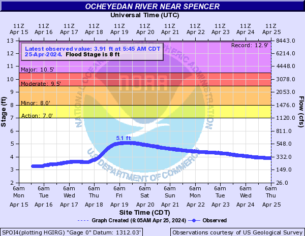
Ocheyedan River Near Spencer (SPOI4)
Return to TopNOTE: River forecasts for this location take into account past precipitation and the precipitation amounts expected approximately 48 hours into the future from the forecast issuance time.
Flood Stage: 8 Feet
Latest Stage: 4.27
Current Warnings/Statements/Advisories:None currently.
Flood ImpactsIf you notice any errors in the below information, please contact our Webmaster
17.5
the bridge on County Road M38 at the gage is overtopped.
16.5
the bridge south of the Ocheyedan WMA is overtopped.
14.5
water reaches the bottom of the bridges south of the Ocheyedan WMA and on County Road M38, and the bridge north of the Ocheyedan WMA is overtopped.
12.5
water reaches the bottom of the bridge north of the Ocheyedan WMA.
10.5
major agricultural flooding begins and some county roads are also flooded.
9.5
significant amounts of pasture and other farm land begin flooding.
8
minor flooding of pasture land begins.
7
minor flooding of some ditches begins.
Flood Categories (in feet)
| Major Flood Stage: |
10.5 |
| Moderate Flood Stage: |
9.5 |
| Flood Stage: |
8 |
| Action Stage: |
7 |
| Low Stage (in feet): |
-9999 |
Historic Crests
(1) 12.89 ft on 06/18/1953
(2) 12.77 ft on 09/21/2018
(3) 12.73 ft on 03/15/2019
(4) 12.70 ft on 06/21/2018
(5) 11.72 ft on 08/11/2010
Show More Historic Crests
(P): Preliminary values subject to further review.
Recent Crests
(1) 6.70 ft on 04/03/2023
(2) 6.46 ft on 05/31/2022
(3) 3.05 ft on 04/09/2021
(4) 8.57 ft on 05/27/2020
(5) 12.73 ft on 03/15/2019
Show More Recent Crests
(P): Preliminary values subject to further review.
Low Water Records
Currently none available.
West Fork Ditch At Moville (WFMI4)
Return to TopNOTE: No forecasts are available for this location
Flood Stage: 0 KCFS
Latest Flow: n/a
Current Warnings/Statements/Advisories:None currently.
Flood ImpactsIf you notice any errors in the below information, please contact our Webmaster
1151
Highway 20 west of Moville will be flooded and the Moville Blacktop at Highway 20 will be flooded.
1150.5
110th Street west of Highway 140 will be flooded.
1149.5
the north lane of Highway 20 near the Moville Blacktop will begin flooding.
1149
Miller Boulevard in Moville will be flooded.
1145
flooding begins to affect fields between Kingsley and Moville
Flood Categories (in feet)
| Major Flood Stage: |
1151 |
| Moderate Flood Stage: |
1149 |
| Flood Stage: |
1145 |
| Action Stage: |
1143 |
| Low Stage (in feet): |
-9999 |
Historic Crests
(1) 1,151.31 ft on 03/14/2019
(2) 1,133.10 ft on 03/16/2023
(3) 1,131.59 ft on 05/28/2020
(P): Preliminary values subject to further review.
Recent Crests
(1) 1,133.10 ft on 03/16/2023
(2) 1,131.59 ft on 05/28/2020
(3) 1,151.31 ft on 03/14/2019
(P): Preliminary values subject to further review.
Low Water Records
Currently none available.
West Fork Ditch Near Hornick (HOKI4)
Return to TopNOTE: River forecasts for this location take into account past precipitation and the precipitation amounts expected approximately 48 hours into the future from the forecast issuance time.
Flood Stage: 20 Feet
Latest Stage: 7.35
Current Warnings/Statements/Advisories:None currently.
Flood ImpactsIf you notice any errors in the below information, please contact our Webmaster
26.5
Grundy Avenue and 300th Street will be flooded near Holly Springs, and 310th Street near Grundy Avenue will be flooded. The water reaches the bottom of the bridge at Holly Springs and the bridge 1 mile southeast of Hornick. The levees along the West Fork Ditch will be overtopped resulting in flooding in Hornick and Holly Springs.
22
all agricultural land immediately adjacent to the ditch will be flooded and the communities of Hornick and Holly Springs will have flood problems if the levees fail.
20
large areas of agricultural land will flood if the levees fail.
Flood Categories (in feet)
| Major Flood Stage: |
26.5 |
| Moderate Flood Stage: |
22 |
| Flood Stage: |
20 |
| Action Stage: |
18 |
| Low Stage (in feet): |
-9999 |
Historic Crests
(1) 26.52 ft on 03/14/2019
(2) 25.87 ft on 06/22/1996
(3) 25.20 ft on 03/30/1960
(4) 23.70 ft on 08/18/2015
(5) 23.59 ft on 06/17/2014
Show More Historic Crests
(P): Preliminary values subject to further review.
Recent Crests
(1) 18.74 ft on 02/27/2023
(2) 7.82 ft on 03/25/2021
(3) 13.77 ft on 12/29/2019
(4) 26.52 ft on 03/14/2019
(5) 0.00 ft on 02/12/2017
Show More Recent Crests
(P): Preliminary values subject to further review.
Low Water Records
Currently none available.
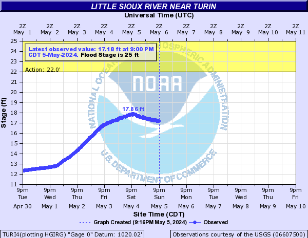
Little Sioux River Near Turin (TURI4)
Return to TopNOTE: River forecasts for this location take into account past precipitation and the precipitation amounts expected approximately 24 hours into the future from the forecast issuance time.
Flood Stage: 25 Feet
Latest Stage: 10.89
Current Warnings/Statements/Advisories:None currently.
Flood ImpactsIf you notice any errors in the below information, please contact our Webmaster
37
Water reaches the bottom of the E54 bridge at the gage site.
34.5
Water nears the top of the federal levee.
25
Flooding may begin near the mouth of the river downstream of Interstate 29. Upstream of the Interstate the river is contained within the levee system.
22
Water exceeds the top of the natural channel but still remains within the confines of the levee system.
Flood Categories (in feet)
| Major Flood Stage: |
34.5 |
| Moderate Flood Stage: |
28 |
| Flood Stage: |
25 |
| Action Stage: |
22 |
| Low Stage (in feet): |
-9999 |
Historic Crests
(1) 29.57 ft on 03/15/2019
(2) 27.44 ft on 02/19/1971
(3) 26.99 ft on 06/22/1996
(4) 26.54 ft on 06/21/1983
(5) 26.47 ft on 03/19/1978
Show More Historic Crests
(P): Preliminary values subject to further review.
Recent Crests
(1) 10.25 ft on 06/05/2022
(2) 9.07 ft on 03/04/2021
(3) 16.02 ft on 02/24/2020
(4) 29.57 ft on 03/15/2019
(5) 23.86 ft on 09/25/2018
Show More Recent Crests
(P): Preliminary values subject to further review.
Low Water Records
Currently none available.