Flood ImpactsIf you notice any errors in the below information, please contact our Webmaster
19.5
Water reaches the bottom of the bridge on 461st Avenue near Lodi, and the highest levees will be overtopped.
19
The intersection of Highway 19 and 46 begins to flood. The bridge on 302nd Street 1 mile east of Colfax Corner is overtopped.
18.5
The bridge on highway 19 near Lodi, and the bridge on 461st Avenue northeast of Colfax Corner, are both overtopped.
18
Water reaches the bottom of the bridge on 303rd Street between Lodi and Colfax Corner.
17.5
The bridge on 304th Street west of Dalesburg is overtopped. Water reaches the bottom of the bridge on Highway 19 at the gauge location.
17
Highway 19 south of Centerville is flooded. Water reaches the bottom of the bridge on 302nd Street east of Colfax Corner, and many of the levees will start to be overtopped with approximately 25000 acres flooded between Davis and Vermillion.
16.5
Hwy 19 north of the gage location begins to flood. Water reaches the bottom of the bridge on 461st Avenue northeast of Colfax Corner, and major flooding of agricultural land south of Davis begins.
16
Water reaches the bottom of the bridge on 304th Street west of Dalesburg, Highway 19 near 299th Street begins to flood, 302nd Street near Colfax Corner will be flooded, and approximately 10000 acres could be flooded between Centerville and Vermillion.
15.5
Water reaches the bottom of the bridge on highway 19 near Lodi, and 306th Street near Hub City will flood along with several other county roads.
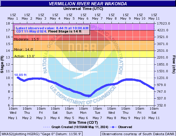
15
Highway 19 south of Centerville could start flooding if the levees fail.
14
Minor flooding of low lying areas begins in non-leveed areas and some agricultural land will flood if the levees fail.
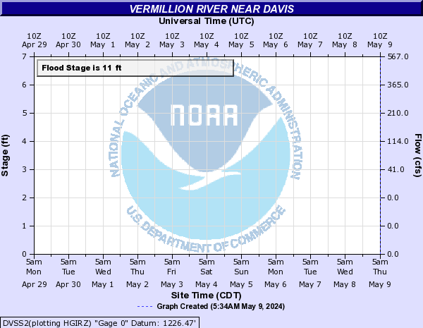
Flood Categories (in feet)
| Major Flood Stage: |
17 |
| Moderate Flood Stage: |
15.5 |
| Flood Stage: |
14 |
| Action Stage: |
13 |
| Low Stage (in feet): |
-9999 |
Historic Crests
(1) 18.11 ft on 03/15/2019
(2) 17.62 ft on 06/23/1984
(3) 17.60 ft on 03/17/2010
(4) 17.50 ft on 06/25/2018
(5) 17.38 ft on 03/20/2011
Show More Historic Crests
(P): Preliminary values subject to further review.
Recent Crests
(1) 10.46 ft on 04/05/2023
(2) 15.10 ft on 03/09/2020
(3) 18.11 ft on 03/15/2019
(4) 17.50 ft on 06/25/2018
(5) 12.64 ft on 05/01/2017
Show More Recent Crests
(P): Preliminary values subject to further review.
Low Water Records
Currently none available.