Brazos River At Waco (WBAT2)
Return to TopNOTE: River forecasts for this location take into account past precipitation and the precipitation amounts expected approximately 24 hours into the future from the forecast issuance time.
Flood Stage: 27 Feet
Latest Stage: 2.47
Current Warnings/Statements/Advisories:None currently.
Flood Categories (in feet)
| Major Flood Stage: |
37 |
| Moderate Flood Stage: |
30 |
| Flood Stage: |
27 |
| Action Stage: |
17 |
| Low Stage (in feet): |
0 |
Historic Crests
(1) 40.90 ft on 09/27/1936
(2) 39.70 ft on 12/03/1913
(3) 36.70 ft on 04/22/1945
(4) 36.70 ft on 05/25/1908
(5) 36.60 ft on 05/02/1944
Show More Historic Crests
(P): Preliminary values subject to further review.
Recent Crests
(1) 34.38 ft on 06/30/1999
(2) 26.50 ft on 12/21/1991
(3) 24.35 ft on 05/12/1990
(4) 34.63 ft on 05/28/1985
(5) 23.49 ft on 04/20/1977
Show More Recent Crests
(P): Preliminary values subject to further review.
Brazos River Near Highbank (HIBT2)
Return to TopNOTE: River forecasts for this location take into account past precipitation and the precipitation amounts expected approximately 24 hours into the future from the forecast issuance time.
Flood Stage: 35 Feet
Latest Stage: 3.1
Current Warnings/Statements/Advisories:None currently.
Flood Categories (in feet)
| Major Flood Stage: |
40 |
| Moderate Flood Stage: |
38 |
| Flood Stage: |
35 |
| Action Stage: |
33 |
| Low Stage (in feet): |
0 |
Historic Crests
(1) 42.00 ft on 12/01/1913
(2) 40.00 ft on 01/01/1936
(3) 30.78 ft on 12/22/1991
(4) 23.90 ft on 02/04/1986
(5) 23.47 ft on 05/04/1990
Show More Historic Crests
(P): Preliminary values subject to further review.
Recent Crests
(1) 30.78 ft on 12/22/1991
(2) 23.47 ft on 05/04/1990
(3) 23.09 ft on 05/18/1989
(4) 20.08 ft on 06/13/1987
(5) 23.90 ft on 02/04/1986
Show More Recent Crests
(P): Preliminary values subject to further review.
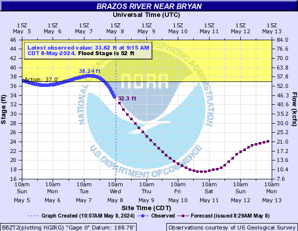
Brazos River Near Bryan (BBZT2)
Return to TopNOTE: River forecasts for this location take into account past precipitation and the precipitation amounts expected approximately 24 hours into the future from the forecast issuance time.
Flood Stage: 52 Feet
Latest Stage: 10.39
Current Warnings/Statements/Advisories:None currently.
Flood Categories (in feet)
| Major Flood Stage: |
66 |
| Moderate Flood Stage: |
60 |
| Flood Stage: |
52 |
| Action Stage: |
37 |
| Low Stage (in feet): |
0 |
Historic Crests
(1) 46.49 ft on 07/16/2007
(2) 46.45 ft on 05/28/2015
(3) 46.21 ft on 01/05/2019
(4) 43.99 ft on 05/30/2007
(5) 43.23 ft on 11/02/2015
Show More Historic Crests
(P): Preliminary values subject to further review.
Recent Crests
(1) 37.60 ft on 06/03/2021
(2) 46.21 ft on 01/05/2019
(3) 37.60 ft on 04/13/2017
(4) 42.13 ft on 04/20/2016
(5) 39.56 ft on 03/12/2016
Show More Recent Crests
(P): Preliminary values subject to further review.
Brazos River Near Hempstead (HPDT2)
Return to TopNOTE: River forecasts for this location take into account past precipitation and the precipitation amounts expected approximately 24 hours into the future from the forecast issuance time.
Flood Stage: 50 Feet
Latest Stage: 16.89
Current Warnings/Statements/Advisories:None currently.
Flood Categories (in feet)
| Major Flood Stage: |
55 |
| Moderate Flood Stage: |
53 |
| Flood Stage: |
50 |
| Action Stage: |
25 |
| Low Stage (in feet): |
-9999 |
Historic Crests
(1) 66.10 ft on 12/08/1913
(2) 63.60 ft on 07/04/1899
(3) 54.89 ft on 05/27/2016
(4) 54.21 ft on 05/02/1957
(5) 54.04 ft on 11/30/1940
Show More Historic Crests
(P): Preliminary values subject to further review.
Recent Crests
(1) 51.24 ft on 08/28/2017
(2) 54.89 ft on 05/27/2016
(3) 43.96 ft on 04/22/2016
(4) 43.75 ft on 03/15/2016
(5) 49.97 ft on 05/31/2015
Show More Recent Crests
(P): Preliminary values subject to further review.
Brazos River At Richmond (RMOT2)
Return to TopNOTE: River forecasts for this location take into account past precipitation and the precipitation amounts expected approximately 24 hours into the future from the forecast issuance time.
Flood Stage: 45 Feet
Latest Stage: 15.11
Current Warnings/Statements/Advisories:None currently.
Flood Categories (in feet)
| Major Flood Stage: |
50 |
| Moderate Flood Stage: |
48 |
| Flood Stage: |
45 |
| Action Stage: |
20 |
| Low Stage (in feet): |
0 |
Historic Crests
(1) 55.19 ft on 09/01/2017
(2) 54.74 ft on 06/02/2016
(3) 51.40 ft on 11/28/1940
(4) 50.30 ft on 10/21/1994
(5) 50.13 ft on 05/05/1957
Show More Historic Crests
(P): Preliminary values subject to further review.
Recent Crests
(1) 46.59 ft on 01/10/2019
(2) 55.19 ft on 09/01/2017
(3) 54.74 ft on 06/02/2016
(4) 49.67 ft on 04/21/2016
(5) 44.46 ft on 03/17/2016
Show More Recent Crests
(P): Preliminary values subject to further review.
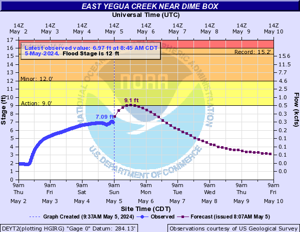
East Yegua Creek Near Dime Box (DEYT2)
Return to TopNOTE: River forecasts for this location take into account past precipitation and the precipitation amounts expected approximately 24 hours into the future from the forecast issuance time.
Flood Stage: 12 Feet
Latest Stage: 1.6
Current Warnings/Statements/Advisories:None currently.
Flood Categories (in feet)
| Major Flood Stage: |
20 |
| Moderate Flood Stage: |
16 |
| Flood Stage: |
12 |
| Action Stage: |
9 |
| Low Stage (in feet): |
-9999 |
Historic Crests
(1) 15.25 ft on 05/04/2019
(2) 14.95 ft on 09/10/2001
(3) 13.91 ft on 05/24/1975
(4) 13.08 ft on 05/26/2015
(5) 13.07 ft on 09/14/1974
Show More Historic Crests
(P): Preliminary values subject to further review.
Recent Crests
(1) 15.25 ft on 05/04/2019
(2) 10.48 ft on 03/30/2018
(3) 12.39 ft on 08/29/2017
(4) 11.65 ft on 05/27/2016
(5) 13.08 ft on 05/26/2015
Show More Recent Crests
(P): Preliminary values subject to further review.
Low Water Records
(1) 1.20 ft on 03/14/1988
Middle Yegua Creek Near Dime Box (DMYT2)
Return to TopNOTE: River forecasts for this location take into account past precipitation and the precipitation amounts expected approximately 24 hours into the future from the forecast issuance time.
Flood Stage: 10 Feet
Latest Stage: 1.6
Current Warnings/Statements/Advisories:None currently.
Flood Categories (in feet)
| Major Flood Stage: |
20 |
| Moderate Flood Stage: |
15 |
| Flood Stage: |
10 |
| Action Stage: |
8 |
| Low Stage (in feet): |
-9999 |
Historic Crests
(1) 15.56 ft on 05/04/2019
(2) 15.39 ft on 12/22/1991
(3) 15.16 ft on 05/24/1975
(4) 14.60 ft on 11/05/2002
(5) 14.36 ft on 11/23/2004
Show More Historic Crests
(P): Preliminary values subject to further review.
Recent Crests
(1) 10.11 ft on 06/05/2021
(P)
(2) 11.71 ft on 05/10/2019
(3) 15.56 ft on 05/04/2019
(4) 12.11 ft on 01/04/2019
(5) 10.10 ft on 01/03/2019
Show More Recent Crests
(P): Preliminary values subject to further review.
Low Water Records
(1) 0.80 ft on 03/02/1981
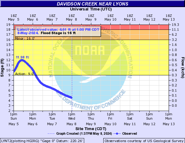
Davidson Creek Near Lyons (LYNT2)
Return to TopNOTE: River forecasts for this location take into account past precipitation and the precipitation amounts expected approximately 24 hours into the future from the forecast issuance time.
Flood Stage: 16 Feet
Latest Stage: 2.55
Current Warnings/Statements/Advisories:None currently.
Flood Categories (in feet)
| Major Flood Stage: |
20 |
| Moderate Flood Stage: |
18 |
| Flood Stage: |
16 |
| Action Stage: |
9 |
| Low Stage (in feet): |
-9999 |
Historic Crests
(1) 19.47 ft on 08/28/2017
(2) 19.33 ft on 10/17/1994
(3) 18.67 ft on 06/24/1968
(4) 18.47 ft on 02/21/2003
(5) 17.89 ft on 04/25/1990
Show More Historic Crests
(P): Preliminary values subject to further review.
Recent Crests
(1) 16.81 ft on 05/29/2021
(2) 12.22 ft on 04/11/2020
(3) 17.71 ft on 05/04/2019
(4) 16.03 ft on 01/03/2019
(5) 16.94 ft on 12/27/2018
Show More Recent Crests
(P): Preliminary values subject to further review.
Low Water Records
(1) 3.33 ft on 01/18/2011
(2) 7.06 ft on 05/11/2971
(3) 8.85 ft on 07/05/2006