Flood ImpactsIf you notice any errors in the below information, please contact our Webmaster
56.1
Water reaches the top of the US 41 bridge railing.
53.4
Water begins to flood the US 41 bridge travel lanes.
52.7
Water reaches the top of the US 27 bridge railing.
50.5
Water begins to flood the US 27 bridge travel lanes.
48.5
Water reaches the approach road surface to the US 27 bridge.
48
Water reaches the base of the US 41 bridge. In Columbia County, residences south of Southwest Mapleton Street and east of Ada Court begin to flood. In Alachua County, homes on Northwest 282nd Drive experience significant flooding.
47.5
Water reaches the approach road surface to the US 41 bridge. In Alachua County, several structures in Camp Kulaqua along Hornsby Spring flood at this level.
47
The Santa Fe Bar on US-441 near the bridge in Columbia County begins to flood at this level.
46
Water reaches the base of the US 27 bridge. A structure begins to flood in Camp Kulaqua along Hornsby Spring just north of Northwest 212th Avenue in Alachua County.
45
In Alachua County, flood waters reach Northwest 212nd Avenue, restricting access to Stillwaters Lodge. Further downstream, homes immediately along the river off Northwest 282nd drive begin to flood.
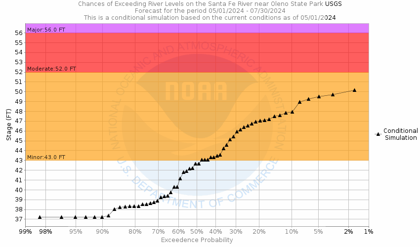
43
In Columbia County, water enters homes off Southeast Resort Circle. In Alachua County, flooding begins to affect areas along Hornsby Spring in Camp Kulaqua.
42
In Columbia County, the southern end of Southwest Woodland Avenue floods.
41
In Columbia County, several homes at Southeast Resort Circle are surrounded by flood waters. Outbuildings flood at this level.
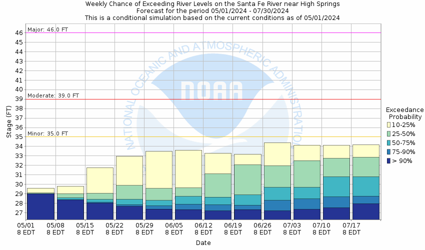
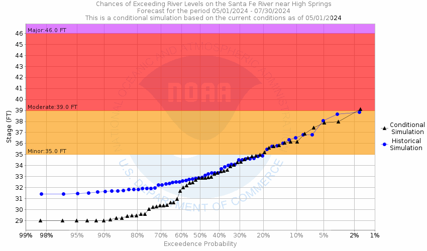
39
In Columbia County, Southeast Resort Circle floods near the entrance of the subdivision, restricting access to all homes in the area.
37
Water begins to approach two residences along the river at the end of Southeast Resort Circle in Columbia County. The boat ramp near the US-27 bridge in Columbia County begins to flood at this level.
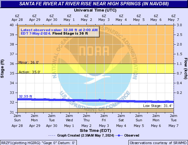
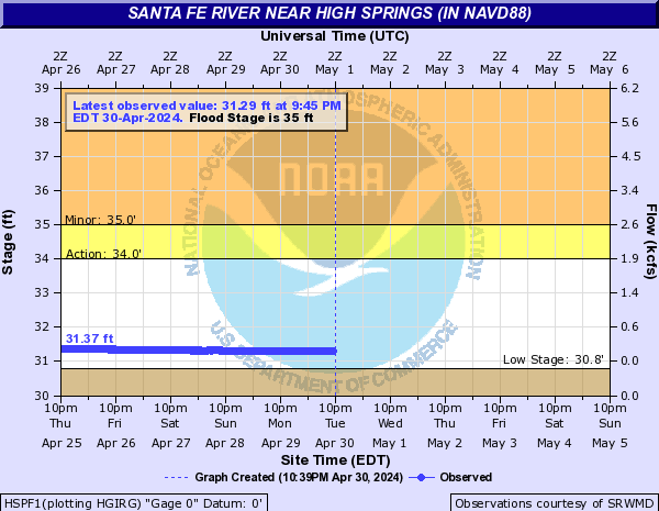
35
Wooded areas along the river begin to flood. The boat ramp south of US-441 in Alachua County is inaccessible above this level.
34.2
Florida Fish and Wildlife Commission begins enforcement of a no wake zone on the Santa Fe River from the River Rise in O'Leno State Park downstream to the center line of the US 27 Bridge.
33
High water will begin to impact docks and boat ramps in the area.
Flood Categories (in feet)
| Major Flood Stage: |
46 |
| Moderate Flood Stage: |
39 |
| Flood Stage: |
35 |
| Action Stage: |
34 |
| Low Stage (in feet): |
30.8 |
Historic Crests
(1) 48.46 ft on 09/14/2017
(2) 45.04 ft on 06/30/2012
(3) 44.52 ft on 09/16/1964
(4) 44.43 ft on 10/06/1992
(5) 43.95 ft on 02/25/1998
(6) 42.03 ft on 09/11/2004
(7) 41.78 ft on 10/14/1996
(8) 41.27 ft on 03/14/1948
(9) 40.86 ft on 07/12/2021
(10) 40.46 ft on 06/18/1934
Show More Historic Crests
(P): Preliminary values subject to further review.
Recent Crests
(1) 35.34 ft on 03/29/2022
(2) 35.39 ft on 03/17/2022
(3) 35.83 ft on 08/10/2021
(4) 40.86 ft on 07/12/2021
(5) 36.52 ft on 08/06/2018
(6) 48.46 ft on 09/14/2017
(7) 33.97 ft on 09/17/2015
(8) 34.71 ft on 09/11/2014
(9) 33.54 ft on 04/03/2014
(10) 34.75 ft on 03/23/2014
Show More Recent Crests
(P): Preliminary values subject to further review.
Low Water Records (1) 30.15 ft on 05/26/2012
(2) 30.92 ft on 09/18/2011
(3) 30.96 ft on 11/07/2002
(4) 31.13 ft on 01/03/2008
(5) 31.17 ft on 12/28/2007
Show More Low Water Records