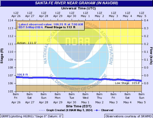
Santa Fe River Near Graham (in NAVD88) (GRMF1)
Return to TopNOTE: Flood stages and impact descriptions for this site are referenced to the NAVD88 datum. Additional datum information can be found at the bottom of this page.
Flood Stage: 113 Feet
Latest Stage: 107.5
Current Warnings/Statements/Advisories:None currently.
Gauge Location
Latitude/Longitude Disclaimer: The gauge location shown in the above map
is the approximate location based on the latitude/longitude coordinates
provided to the NWS by the gauge owner.
Flood Categories (in feet)
| Major Flood Stage: |
118 |
| Moderate Flood Stage: |
115 |
| Flood Stage: |
113 |
| Action Stage: |
111 |
| Low Stage (in feet): |
105.8 |
Historic Crests
(1) 118.98 ft on 09/11/2017
(2) 117.68 ft on 09/12/1964
(3) 117.22 ft on 02/04/1970
(4) 116.98 ft on 03/29/1970
(P)
(5) 116.55 ft on 02/23/1998
(6) 116.51 ft on 06/27/2012
(7) 116.22 ft on 08/31/1968
(8) 116.18 ft on 07/07/2021
(9) 116.16 ft on 10/04/1992
(10) 116.10 ft on 05/21/1959
Show More Historic Crests
(P): Preliminary values subject to further review.
Recent Crests
(1) 113.56 ft on 12/19/2023
(2) 114.56 ft on 09/11/2022
(3) 114.42 ft on 03/24/2022
(4) 115.15 ft on 03/12/2022
(5) 113.88 ft on 09/20/2021
(6) 114.01 ft on 09/20/2021
(7) 113.07 ft on 09/19/2021
(8) 116.18 ft on 07/07/2021
(9) 113.74 ft on 06/26/2021
(10) 114.07 ft on 06/22/2021
Show More Recent Crests
(P): Preliminary values subject to further review.
Low Water Records
(1) 105.28 ft on 06/21/2011
Santa Fe River At Worthington Springs (in NAVD88) (WORF1)
Return to TopNOTE: River forecasts for this location take into account past precipitation and the precipitation amounts expected approximately 48 hours into the future from the forecast issuance time.
NOTE: Flood stages and impact descriptions for this site are referenced to the NAVD88 datum. Additional datum information can be found at the bottom of this page.
Flood Stage: 59 Feet
Latest Stage: 52.98
Current Warnings/Statements/Advisories:None currently.
Gauge Location
Latitude/Longitude Disclaimer: The gauge location shown in the above map
is the approximate location based on the latitude/longitude coordinates
provided to the NWS by the gauge owner.
Flood Categories (in feet)
| Major Flood Stage: |
66 |
| Moderate Flood Stage: |
64 |
| Flood Stage: |
59 |
| Action Stage: |
56 |
| Low Stage (in feet): |
49.4 |
Historic Crests
(1) 71.17 ft on 09/12/2017
(2) 70.31 ft on 09/13/1964
(3) 67.46 ft on 10/05/1992
(4) 66.94 ft on 06/28/2012
(5) 66.85 ft on 10/21/1944
(6) 66.74 ft on 06/17/1934
(7) 66.59 ft on 09/01/1968
(8) 66.52 ft on 10/22/1941
(9) 66.51 ft on 03/12/1948
(10) 66.49 ft on 09/26/1947
Show More Historic Crests
(P): Preliminary values subject to further review.
Recent Crests
(1) 61.20 ft on 12/20/2023
(2) 60.51 ft on 08/04/2023
(3) 60.15 ft on 09/13/2022
(4) 60.99 ft on 03/26/2022
(5) 61.75 ft on 03/14/2022
(6) 59.80 ft on 09/21/2021
(7) 59.77 ft on 08/08/2021
(8) 63.99 ft on 07/09/2021
(9) 60.90 ft on 06/27/2021
(10) 60.24 ft on 02/17/2021
Show More Recent Crests
(P): Preliminary values subject to further review.
Low Water Records (1) 47.59 ft on 07/27/2007
(2) 47.66 ft on 05/28/2012
(3) 47.89 ft on 06/11/2001
(4) 48.34 ft on 06/13/2011
(5) 48.62 ft on 06/10/2008
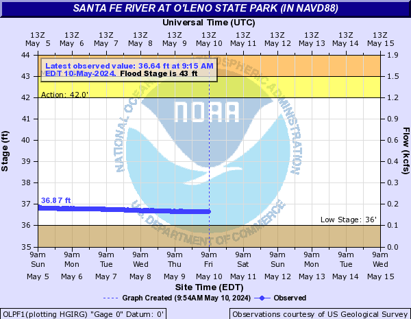
Show More Low Water Records Santa Fe River At O'leno State Park (in NAVD88) (OLPF1)
Return to TopNOTE: River forecasts for this location take into account past precipitation and the precipitation amounts expected approximately 48 hours into the future from the forecast issuance time.
NOTE: Flood stages and impact descriptions for this site are referenced to the NAVD88 datum. Additional datum information can be found at the bottom of this page.
Flood Stage: 43 Feet
Latest Stage: 38.83
Gauge Location
Latitude/Longitude Disclaimer: The gauge location shown in the above map
is the approximate location based on the latitude/longitude coordinates
provided to the NWS by the gauge owner.
Flood Categories (in feet)
| Major Flood Stage: |
56 |
| Moderate Flood Stage: |
52 |
| Flood Stage: |
43 |
| Action Stage: |
42 |
| Low Stage (in feet): |
36 |
Historic Crests
(1) 57.07 ft on 09/14/2017
(2) 54.44 ft on 06/29/2012
(3) 51.05 ft on 07/10/2021
(4) 48.28 ft on 08/05/2018
(5) 47.47 ft on 03/15/2022
(6) 47.35 ft on 12/21/2023
(7) 46.59 ft on 08/09/2021
(8) 46.52 ft on 06/29/2021
(9) 46.50 ft on 03/28/2022
(10) 46.37 ft on 09/10/2014
Show More Historic Crests
(P): Preliminary values subject to further review.
Recent Crests
(1) 47.35 ft on 12/21/2023
(2) 44.66 ft on 08/05/2023
(3) 44.79 ft on 09/14/2022
(4) 43.36 ft on 09/01/2022
(5) 46.50 ft on 03/28/2022
(6) 47.47 ft on 03/15/2022
(7) 45.11 ft on 09/22/2021
(8) 46.59 ft on 08/09/2021
(9) 51.05 ft on 07/10/2021
(10) 46.52 ft on 06/29/2021
Show More Recent Crests
(P): Preliminary values subject to further review.
Low Water Records
(1) 34.92 ft on 05/27/2012
(2) 34.93 ft on 05/24/2012
(3) 34.93 ft on 05/25/2012
(4) 34.93 ft on 05/26/2012
(5) 34.93 ft on 05/28/2012
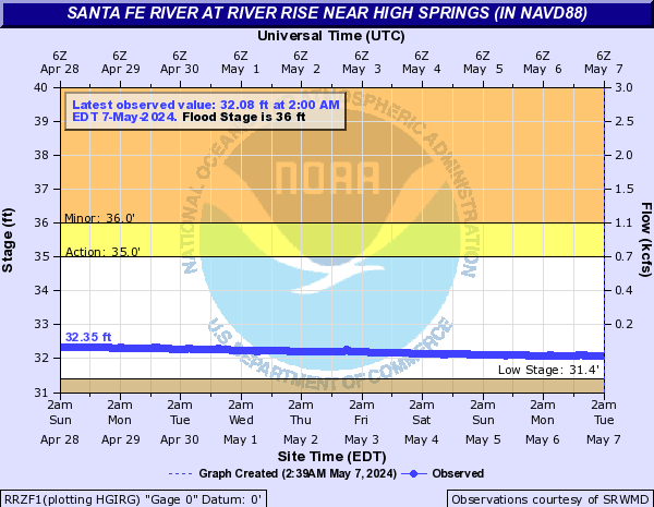
Santa Fe River At River Rise near High Springs (in NAVD88) (RRZF1)
Return to TopNOTE: Flood stages and impact descriptions for this site are referenced to the NAVD88 datum. Additional datum information can be found at the bottom of this page.
Flood Stage: 36 Feet
Latest Stage: 33.01
Gauge Location
Latitude/Longitude Disclaimer: The gauge location shown in the above map
is the approximate location based on the latitude/longitude coordinates
provided to the NWS by the gauge owner.
Flood Categories (in feet)
| Major Flood Stage: |
47 |
| Moderate Flood Stage: |
41 |
| Flood Stage: |
36 |
| Action Stage: |
35 |
| Low Stage (in feet): |
31.4 |
Historic Crests
(1) 50.48 ft on 09/14/2017
(2) 43.62 ft on 07/11/2021
(3) 40.04 ft on 08/05/2018
(4) 39.44 ft on 08/09/2021
(5) 39.17 ft on 03/16/2022
(6) 38.77 ft on 12/22/2023
(7) 38.77 ft on 03/29/2022
(8) 38.67 ft on 06/29/2021
(9) 38.47 ft on 03/22/2014
(10) 38.19 ft on 09/11/2014
Show More Historic Crests
(P): Preliminary values subject to further review.
Recent Crests
(1) 38.77 ft on 12/22/2023
(2) 36.05 ft on 08/05/2023
(3) 36.88 ft on 09/14/2022
(4) 38.77 ft on 03/29/2022
(5) 39.17 ft on 03/16/2022
(6) 37.67 ft on 09/23/2021
(7) 39.44 ft on 08/09/2021
(8) 43.62 ft on 07/11/2021
(9) 38.67 ft on 06/29/2021
(10) 37.65 ft on 02/01/2019
Show More Recent Crests
(P): Preliminary values subject to further review.
Low Water Records
(1) 31.13 ft on 09/05/2002
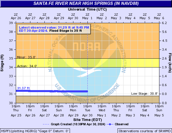
Santa Fe River Near High Springs (in NAVD88) (HSPF1)
Return to TopNOTE: River forecasts for this location take into account past precipitation and the precipitation amounts expected approximately 48 hours into the future from the forecast issuance time.
NOTE: Flood stages and impact descriptions for this site are referenced to the NAVD88 datum. Additional datum information can be found at the bottom of this page.
Flood Stage: 35 Feet
Latest Stage: 31.59
Current Warnings/Statements/Advisories:None currently.
Gauge Location
Latitude/Longitude Disclaimer: The gauge location shown in the above map
is the approximate location based on the latitude/longitude coordinates
provided to the NWS by the gauge owner.
Flood Categories (in feet)
| Major Flood Stage: |
46 |
| Moderate Flood Stage: |
39 |
| Flood Stage: |
35 |
| Action Stage: |
34 |
| Low Stage (in feet): |
30.8 |
Historic Crests
(1) 48.46 ft on 09/14/2017
(2) 45.04 ft on 06/30/2012
(3) 44.52 ft on 09/16/1964
(4) 44.43 ft on 10/06/1992
(5) 43.95 ft on 02/25/1998
(6) 42.03 ft on 09/11/2004
(7) 41.78 ft on 10/14/1996
(8) 41.27 ft on 03/14/1948
(9) 40.86 ft on 07/12/2021
(10) 40.46 ft on 06/18/1934
Show More Historic Crests
(P): Preliminary values subject to further review.
Recent Crests
(1) 35.34 ft on 03/29/2022
(2) 35.39 ft on 03/17/2022
(3) 35.83 ft on 08/10/2021
(4) 40.86 ft on 07/12/2021
(5) 36.52 ft on 08/06/2018
(6) 48.46 ft on 09/14/2017
(7) 33.97 ft on 09/17/2015
(8) 34.71 ft on 09/11/2014
(9) 33.54 ft on 04/03/2014
(10) 34.75 ft on 03/23/2014
Show More Recent Crests
(P): Preliminary values subject to further review.
Low Water Records (1) 30.15 ft on 05/26/2012
(2) 30.92 ft on 09/18/2011
(3) 30.96 ft on 11/07/2002
(4) 31.13 ft on 01/03/2008
(5) 31.17 ft on 12/28/2007
Show More Low Water Records Santa Fe River At Poe Springs Pool (in NAVD88) (POEF1)
Return to TopNOTE: Flood stages and impact descriptions for this site are referenced to the NAVD88 datum. Additional datum information can be found at the bottom of this page.
Flood Stage: 29 Feet
Latest Stage: 25.67
Current Warnings/Statements/Advisories:None currently.
Gauge Location
Latitude/Longitude Disclaimer: The gauge location shown in the above map
is the approximate location based on the latitude/longitude coordinates
provided to the NWS by the gauge owner.
Flood Categories (in feet)
| Major Flood Stage: |
39 |
| Moderate Flood Stage: |
33 |
| Flood Stage: |
29 |
| Action Stage: |
27 |
| Low Stage (in feet): |
25.1 |
Historic Crests
(1) 40.59 ft on 09/15/2017
(2) 37.72 ft on 06/30/2012
(3) 34.78 ft on 09/11/2004
(4) 33.68 ft on 10/01/2004
(5) 33.45 ft on 07/11/2021
(6) 31.55 ft on 03/14/2003
(7) 30.30 ft on 08/06/2018
(8) 30.04 ft on 08/10/2021
(9) 29.88 ft on 08/28/2008
(10) 29.78 ft on 12/23/2023
Show More Historic Crests
(P): Preliminary values subject to further review.
Recent Crests
(1) 29.78 ft on 12/23/2023
(2) 29.49 ft on 03/29/2022
(3) 29.40 ft on 03/17/2022
(4) 30.04 ft on 08/10/2021
(5) 33.45 ft on 07/11/2021
(6) 30.30 ft on 08/06/2018
(7) 40.59 ft on 09/15/2017
(8) 28.79 ft on 09/12/2014
(9) 28.00 ft on 04/03/2014
(10) 28.95 ft on 03/23/2014
Show More Recent Crests
(P): Preliminary values subject to further review.
Low Water Records
(1) 25.46 ft on 06/04/2012
(2) 25.83 ft on 09/18/2007
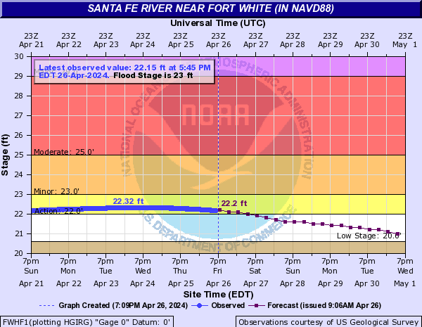
Santa Fe River Near Fort White (in NAVD88) (FWHF1)
Return to TopNOTE: River forecasts for this location take into account past precipitation and the precipitation amounts expected approximately 48 hours into the future from the forecast issuance time.
NOTE: Flood stages and impact descriptions for this site are referenced to the NAVD88 datum. Additional datum information can be found at the bottom of this page.
Flood Stage: 23 Feet
Latest Stage: 21.8
Gauge Location
Latitude/Longitude Disclaimer: The gauge location shown in the above map
is the approximate location based on the latitude/longitude coordinates
provided to the NWS by the gauge owner.
Flood Categories (in feet)
| Major Flood Stage: |
29 |
| Moderate Flood Stage: |
25 |
| Flood Stage: |
23 |
| Action Stage: |
22 |
| Low Stage (in feet): |
20.6 |
Historic Crests
(1) 35.40 ft on 09/16/1964
(2) 34.46 ft on 09/15/2017
(3) 33.76 ft on 04/12/1948
(4) 32.61 ft on 03/15/1948
(5) 32.21 ft on 02/26/1998
(6) 31.45 ft on 06/30/2012
(7) 31.10 ft on 06/20/1934
(8) 30.58 ft on 10/08/1992
(9) 30.41 ft on 03/24/1959
(10) 30.32 ft on 04/19/1973
Show More Historic Crests
(P): Preliminary values subject to further review.
Recent Crests
(1) 23.57 ft on 12/23/2023
(2) 24.36 ft on 03/30/2022
(3) 24.01 ft on 03/18/2022
(4) 24.01 ft on 09/27/2021
(5) 23.17 ft on 09/01/2021
(6) 25.27 ft on 08/12/2021
(7) 27.71 ft on 07/12/2021
(8) 23.41 ft on 07/01/2021
(9) 23.31 ft on 02/23/2021
(10) 24.15 ft on 02/02/2019
Show More Recent Crests
(P): Preliminary values subject to further review.
Low Water Records (1) 20.91 ft on 01/02/2008
(2) 20.92 ft on 12/07/2007
(3) 20.92 ft on 05/26/2012
(4) 20.96 ft on 09/15/2011
(5) 21.07 ft on 01/01/2009
Show More Low Water Records Santa Fe River At Three Rivers Estates (in NAVD88) (TREF1)
Return to TopNOTE: River forecasts for this location take into account past precipitation and the precipitation amounts expected approximately 48 hours into the future from the forecast issuance time.
NOTE: Flood stages and impact descriptions for this site are referenced to the NAVD88 datum. Additional datum information can be found at the bottom of this page.
Flood Stage: 17 Feet
Latest Stage: 20.75
Gauge Location
Latitude/Longitude Disclaimer: The gauge location shown in the above map
is the approximate location based on the latitude/longitude coordinates
provided to the NWS by the gauge owner.
Flood Categories (in feet)
| Major Flood Stage: |
24 |
| Moderate Flood Stage: |
21 |
| Flood Stage: |
17 |
| Action Stage: |
14 |
| Low Stage (in feet): |
7.8 |
Historic Crests
(1) 33.44 ft on 04/12/1948
(2) 30.04 ft on 04/19/1973
(3) 29.16 ft on 03/25/1998
(4) 28.74 ft on 04/14/1984
(5) 27.81 ft on 02/28/1998
(6) 27.24 ft on 03/27/1959
(7) 26.94 ft on 02/25/1986
(8) 26.74 ft on 03/18/1991
(9) 26.09 ft on 03/21/1984
(10) 26.05 ft on 04/17/2009
Show More Historic Crests
(P): Preliminary values subject to further review.
Recent Crests
(1) 17.45 ft on 01/20/2024
(2) 17.12 ft on 12/26/2023
(3) 18.73 ft on 03/31/2022
(4) 19.93 ft on 09/28/2021
(5) 21.30 ft on 08/15/2021
(6) 20.18 ft on 07/14/2021
(7) 20.51 ft on 03/13/2021
(8) 21.18 ft on 03/03/2021
(9) 17.34 ft on 03/11/2019
(10) 20.27 ft on 02/12/2019
Show More Recent Crests
(P): Preliminary values subject to further review.
Low Water Records (1) 6.65 ft on 06/10/2011
(2) 6.73 ft on 05/26/2012
(3) 6.94 ft on 12/30/2010
(4) 8.03 ft on 02/10/2013
(5) 9.04 ft on 06/28/2015
Show More Low Water Records Santa Fe River Near Hildreth (in NAVD88) (FTWF1)
Return to TopNOTE: River forecasts for this location take into account past precipitation and the precipitation amounts expected approximately 48 hours into the future from the forecast issuance time.
NOTE: Flood stages and impact descriptions for this site are referenced to the NAVD88 datum. Additional datum information can be found at the bottom of this page.
Flood Stage: 20 Feet
Latest Stage: 20.58
Gauge Location
Latitude/Longitude Disclaimer: The gauge location shown in the above map
is the approximate location based on the latitude/longitude coordinates
provided to the NWS by the gauge owner.
Flood Categories (in feet)
| Major Flood Stage: |
28 |
| Moderate Flood Stage: |
26 |
| Flood Stage: |
20 |
| Action Stage: |
18 |
| Low Stage (in feet): |
6.4 |
Historic Crests
(1) 33.41 ft on 04/12/1948
(2) 29.97 ft on 04/19/1973
(3) 28.75 ft on 03/24/1998
(4) 28.05 ft on 03/25/1948
(5) 27.22 ft on 03/27/1959
(P)
(6) 26.76 ft on 02/25/1986
(7) 26.75 ft on 03/01/1998
(8) 26.44 ft on 03/18/1991
(9) 26.29 ft on 09/19/1964
(10) 26.11 ft on 11/26/1947
Show More Historic Crests
(P): Preliminary values subject to further review.
Recent Crests
(1) 20.87 ft on 08/17/2021
(2) 20.29 ft on 03/14/2021
(3) 20.92 ft on 03/03/2021
(4) 22.95 ft on 12/29/2018
(5) 21.22 ft on 09/17/2017
(6) 18.20 ft on 03/11/2015
(7) 24.60 ft on 05/02/2014
(8) 19.99 ft on 03/29/2014
(9) 19.90 ft on 09/03/2013
(10) 18.22 ft on 07/24/2013
Show More Recent Crests
(P): Preliminary values subject to further review.
Low Water Records (1) 5.19 ft on 05/27/2012
(2) 5.44 ft on 12/11/2011
(3) 5.88 ft on 12/18/2007
(4) 5.92 ft on 01/03/2008
(5) 6.19 ft on 12/28/2010
Show More Low Water Records New River Near Lake Butler (in NAVD88) (NRBF1)
Return to TopNOTE: Flood stages and impact descriptions for this site are referenced to the NAVD88 datum. Additional datum information can be found at the bottom of this page.
Flood Stage: 91 Feet
Latest Stage: 86.47
Current Warnings/Statements/Advisories:None currently.
Gauge Location
Latitude/Longitude Disclaimer: The gauge location shown in the above map
is the approximate location based on the latitude/longitude coordinates
provided to the NWS by the gauge owner.
Flood Categories (in feet)
| Major Flood Stage: |
94 |
| Moderate Flood Stage: |
92.5 |
| Flood Stage: |
91 |
| Action Stage: |
89 |
| Low Stage (in feet): |
84.3 |
Historic Crests
(1) 98.55 ft on 09/12/2017
(2) 98.25 ft on 09/12/1964
(3) 97.46 ft on 10/04/1992
(4) 96.90 ft on 06/27/2012
(5) 95.72 ft on 08/31/1968
(6) 95.38 ft on 02/18/1998
(P)
(7) 95.09 ft on 08/23/2003
(8) 94.94 ft on 09/08/1950
(9) 94.93 ft on 03/30/1970
(10) 94.80 ft on 02/04/1970
(P)
Show More Historic Crests
(P): Preliminary values subject to further review.
Recent Crests
(1) 92.94 ft on 12/19/2023
(2) 93.56 ft on 08/02/2023
(3) 91.66 ft on 09/11/2022
(4) 92.28 ft on 03/25/2022
(5) 92.44 ft on 03/12/2022
(6) 91.29 ft on 09/24/2021
(7) 91.56 ft on 08/06/2021
(8) 93.65 ft on 07/08/2021
(9) 92.72 ft on 06/26/2021
(10) 92.01 ft on 02/16/2021
Show More Recent Crests
(P): Preliminary values subject to further review.
Low Water Records (1) 83.44 ft on 08/20/1954
(2) 83.45 ft on 06/24/1955
(3) 83.51 ft on 06/12/2000
(4) 83.60 ft on 04/23/1956
(5) 83.64 ft on 06/10/1951
Show More Low Water Records