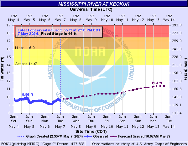
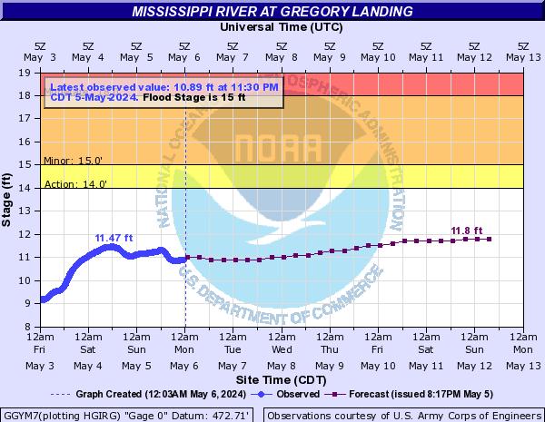
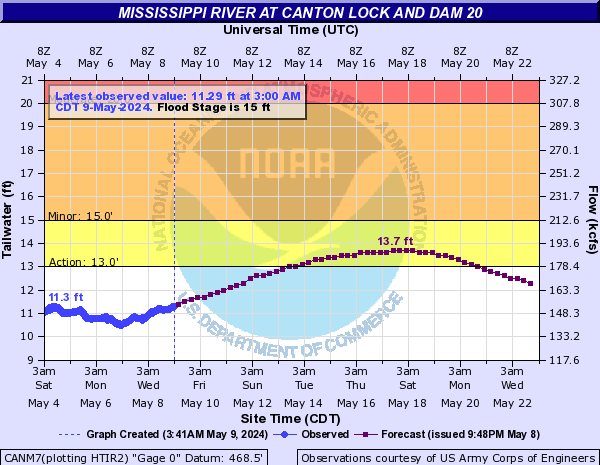
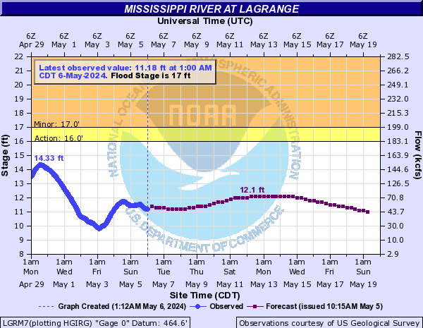
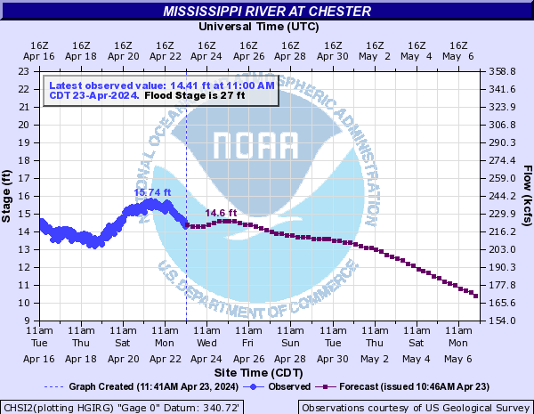
Flood ImpactsIf you notice any errors in the below information, please contact our Webmaster
50
Floodwall at Caruthersville, Missouri holds to 50 feet.
47.6
This is the flood of record.
45
Terminal elevators north of Caruthersville, Missouri are flooding.
44
In Tennessee, the Farmer Levee that goes south of Interstate 155 and on through Heloise, Midway, and Chic is topped at many places. All land east of the Farmer Levee to the Corps Levee is flooded or will flood soon. Elevator just south of the Interstate 155 bridge is flooding. Most land in northwestern Lauderdale County and western Dyer County west of the bluffs is flooded.
43
In Missouri, some sections along the Caruthersville Floodwall have 4 feet of water against them.
42
In Tennessee, Heloise is flooded. Road to the steel plant's dock in Arkansas is flooding.
41
In Missouri, the floodwall at Caruthersville has two feet of water against it at some places. In Tennessee, water tops the Tennemo Levee. Access road to the house at Ayers is covered. Water is deep and fast over most of Highway 88 in the Lauderdale County north bottom.
40.5
In Missouri, the boat fabrication factory north of Caruthersville is mostly underwater. Some of the floodwall at Caruthersville has a foot of water against it. Access road to the grain elevator northeast of Huffman, Arkansas is flooded. West end of Bradley Road in Lauderdale County, Tennessee is flooded.
40
In Tennessee, Highway 88 is flooded at many places. Backwater coming up the Obion and Forked Deer Rivers has flooded most unprotected land in western Dyer County and the north bottom of Lauderdale County. Backwater has reached Miston, Finley, and Four Points. Backwater has nearly reached Lennox, Richmond Road, and Paw Paw Ridge. Parker Road in Lake County is flooded. In Arkansas, the road to the grain terminal east of Blytheville is flooded. Fields inside the levee are flooded in Pemiscot County, Missouri.
39
Floodwater has reached the foot of the floodwall protecting Caruthersville, Missouri. In Tennessee, the grain terminal south of the Interstate 155 bridge is flooding. Highway 88 is flooded at places in the north bottom of Lauderdale County. Roads to and from Chisholm Lake are flooding.
38
In Missouri, parking lots of the casino in Caruthersville, Missouri, are flooding. Evacuation route from residence inside levee near Cottonwood Point is shut. In Tennessee, several homes in the Barr Point area will be cut off due to high water. Road to the boat ramp near the mouth of the Obion River is covered.
37.5
In Tennessee, Route 104 between Mengelwood and the levee is flooding. Bradley Road just east of the Obion River is nearly flooded.
37
In Missouri, grounds at the casino at Caruthersville are beginning to flood. Farmstead southeast of Cottonwood Point is beginning to flood. In Arkansas, the elevator near Huffman is flooding. Much of Hickman Landing is covered. In Tennessee, Heloise and the east leg of Miss Kelly Loop are flooding.
36
Grain terminal area east of Blytheville, Arkansas is flooding. In Tennessee, overbank flooding from the river is cutting across Barr Point. Suggs Road is flooded through the low spots.
35.5
Route 88 in Lauderdale County, Tennessee is flooded just south of Suggs Road.
35
Grounds of the riverboat factory north of Caruthersville, Missouri are flooding. Park on the riverbank at Caruthersville is beginning to go underwater. In Tennessee, Barr Road is under two feet of water in places and evacuations are very difficult. Most unprotected farm land near the river and portions of Highway 104 in western Dyer County are impacted.
34
In Tennessee, Barr Road along the Middle Fork of the Forked Deer River is flooding near the bridge at the south end of Watkins Road. Water from the north bottom of Lauderdale County is now flowing over the basin boundary into the south bottom of Lauderdale County. In Missouri, large businesses just north of Caruthersville are beginning to flood. Many fields adjacent to the Interstate 155 bridge are flooded.
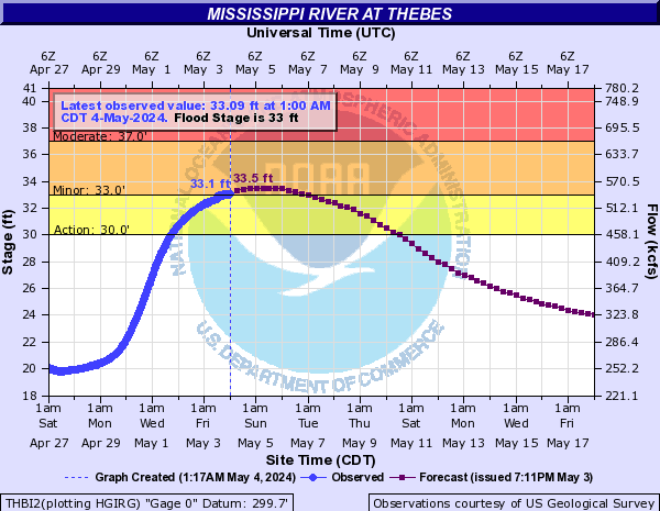
33
In Tennessee, Barr Road in Chickasaw National Wildlife Refuge is flooding, cutting off evacuations from the Wardlows Pocket Area. In Arkansas, docks used by the steel plant at Hickman are mostly flooded. Numerous roads and fields inside the levee between Gayoso and Kennedy, Missouri are covered.
32
In Arkansas, docks of the steel mill near Hickman are flooding. In Tennessee, Mississippi River overbank flooding is occurring across Highway 88 just north of Dee Webb Road. Extensive amounts of Chickasaw National Wildlife Refuge are flooded. Sloughs at the west end of Barr Road are beginning to back up into fields.
31
In Missouri, road and field flooding is widespread at Cottonwood Point. Access roads off Arkansas Road 362 are flooding. In Tennessee, the grain shipping facility south of Heloise is mostly underwater. Dee Webb Road, Watkins Road, and Brady Ridge Road are flooding. Barr Road north of the Wardlows Pocket Area is beginning to flood.
30
Sloughs are flooding fields just north of Chisholm Lake, Tennessee.
29
In Tennessee, the shipping operation south of Heloise is being flooded. Chisholm Lake Road is flooded south of Cocklebur Slough. Overbank flooding begins on low-lying farm land along both banks of the Mississippi River and the Obion River in northwest Tennessee. The Old Forked Deer river bed is beginning to flood fields in the Hales Point Area south of Suggs Road. In Arkansas, roads inside the levee south of Caruthersville, Missouri are beginning to flood.
28
In Tennessee, fields are beginning to flood at Wrights Point.
27
In Tennessee, sloughs are flooding fields in the Wrights Point Area. Chisholm Lake Road is flooded near Possum Slough. Fields and roads in southwestern Dyer County and along the Forked Deer River in northern Lauderdale County are flooding.
24
In Tennessee, numerous low-lying fields, roadside ditches, sloughs, and old riverbeds are in the beginning stages of backwater flooding east of the mouth of the Obion and Forked Deer Rivers. Water is running south into Chisholm Lake from the Forked Deer River.