Skip Navigation Link weather.gov  
NOAA logo - Click to go to the NOAA homepage National Weather Service NWS logo - Click to go to the NWS homepage
Advanced Hydrologic Prediction Service
Image background of Navigation bar Left
Navigation Bar End Cap

Mississippi River At Grafton (GRFI2)

Return to Top
NOTE: River forecasts for this location take into account past precipitation and the precipitation amounts expected approximately 24 hours into the future from the forecast issuance time.
NOTE: For the latest navigation status update from the U.S. Army Corps of Engineers-St. Louis District, click here.
Flood Stage: 20 Feet
Latest Stage: 15.36
Current Warnings/Statements/Advisories:None currently.
at Grafton
Stage (ft)Observed: 15.38 ft at 4:00AM Apr 11, 2024Observed: 15.37 ft at 4:30AM Apr 11, 2024Observed: 15.39 ft at 5:00AM Apr 11, 2024Observed: 15.38 ft at 5:30AM Apr 11, 2024Observed: 15.38 ft at 6:00AM Apr 11, 2024Observed: 15.4 ft at 6:30AM Apr 11, 2024Observed: 15.4 ft at 7:00AM Apr 11, 2024Observed: 15.41 ft at 7:30AM Apr 11, 2024Observed: 15.42 ft at 8:00AM Apr 11, 2024Observed: 15.43 ft at 8:30AM Apr 11, 2024Observed: 15.43 ft at 9:00AM Apr 11, 2024Observed: 15.44 ft at 9:30AM Apr 11, 2024Observed: 15.45 ft at 10:30AM Apr 11, 2024Observed: 15.47 ft at 11:00AM Apr 11, 2024Observed: 15.45 ft at 11:30AM Apr 11, 2024Observed: 15.47 ft at 12:00PM Apr 11, 2024Observed: 15.48 ft at 12:30PM Apr 11, 2024Observed: 15.48 ft at 1:00PM Apr 11, 2024Observed: 15.47 ft at 1:30PM Apr 11, 2024Observed: 15.47 ft at 2:00PM Apr 11, 2024Observed: 15.44 ft at 2:30PM Apr 11, 2024Observed: 15.46 ft at 3:00PM Apr 11, 2024Observed: 15.46 ft at 3:30PM Apr 11, 2024Observed: 15.44 ft at 4:00PM Apr 11, 2024Observed: 15.45 ft at 4:30PM Apr 11, 2024Observed: 15.48 ft at 5:00PM Apr 11, 2024Observed: 15.47 ft at 5:30PM Apr 11, 2024Observed: 15.45 ft at 6:00PM Apr 11, 2024Observed: 15.44 ft at 6:30PM Apr 11, 2024Observed: 15.44 ft at 7:00PM Apr 11, 2024Observed: 15.46 ft at 7:30PM Apr 11, 2024Observed: 15.45 ft at 8:00PM Apr 11, 2024Observed: 15.44 ft at 8:30PM Apr 11, 2024Observed: 15.45 ft at 9:00PM Apr 11, 2024Observed: 15.45 ft at 9:30PM Apr 11, 2024Observed: 15.45 ft at 10:00PM Apr 11, 2024Observed: 15.43 ft at 10:30PM Apr 11, 2024Observed: 15.4 ft at 11:00PM Apr 11, 2024Observed: 15.42 ft at 11:30PM Apr 11, 2024Observed: 15.42 ft at 12:00AM Apr 12, 2024Observed: 15.4 ft at 12:30AM Apr 12, 2024Observed: 15.4 ft at 1:00AM Apr 12, 2024Observed: 15.4 ft at 1:30AM Apr 12, 2024Observed: 15.43 ft at 2:00AM Apr 12, 2024Observed: 15.42 ft at 2:30AM Apr 12, 2024Observed: 15.43 ft at 3:00AM Apr 12, 2024Observed: 15.42 ft at 3:30AM Apr 12, 2024Observed: 15.43 ft at 4:00AM Apr 12, 2024Observed: 15.42 ft at 4:30AM Apr 12, 2024Observed: 15.43 ft at 5:00AM Apr 12, 2024Observed: 15.42 ft at 5:30AM Apr 12, 2024Observed: 15.43 ft at 6:00AM Apr 12, 2024Observed: 15.42 ft at 6:30AM Apr 12, 2024Observed: 15.42 ft at 7:00AM Apr 12, 2024Observed: 15.42 ft at 7:30AM Apr 12, 2024Observed: 15.41 ft at 8:00AM Apr 12, 2024Observed: 15.4 ft at 8:30AM Apr 12, 2024Observed: 15.42 ft at 9:00AM Apr 12, 2024Observed: 15.39 ft at 9:30AM Apr 12, 2024Observed: 15.38 ft at 10:00AM Apr 12, 2024Observed: 15.42 ft at 10:30AM Apr 12, 2024Observed: 15.41 ft at 11:00AM Apr 12, 2024Observed: 15.41 ft at 11:30AM Apr 12, 2024Observed: 15.39 ft at 12:00PM Apr 12, 2024Observed: 15.41 ft at 12:30PM Apr 12, 2024Observed: 15.42 ft at 1:00PM Apr 12, 2024Observed: 15.39 ft at 1:30PM Apr 12, 2024Observed: 15.41 ft at 2:00PM Apr 12, 2024Observed: 15.42 ft at 2:30PM Apr 12, 2024Observed: 15.43 ft at 3:00PM Apr 12, 2024Observed: 15.39 ft at 3:30PM Apr 12, 2024Observed: 15.39 ft at 4:00PM Apr 12, 2024Observed: 15.35 ft at 4:30PM Apr 12, 2024Observed: 15.38 ft at 5:00PM Apr 12, 2024Observed: 15.38 ft at 5:30PM Apr 12, 2024Observed: 15.39 ft at 6:00PM Apr 12, 2024Observed: 15.39 ft at 6:30PM Apr 12, 2024Observed: 15.36 ft at 7:00PM Apr 12, 2024Observed: 15.39 ft at 7:30PM Apr 12, 2024Observed: 15.39 ft at 8:00PM Apr 12, 2024Observed: 15.39 ft at 8:30PM Apr 12, 2024Observed: 15.38 ft at 9:00PM Apr 12, 2024Observed: 15.39 ft at 9:30PM Apr 12, 2024Observed: 15.41 ft at 10:00PM Apr 12, 2024Observed: 15.44 ft at 10:30PM Apr 12, 2024Observed: 15.45 ft at 11:00PM Apr 12, 2024Observed: 15.48 ft at 11:30PM Apr 12, 2024Observed: 15.5 ft at 12:00AM Apr 13, 2024Observed: 15.5 ft at 12:30AM Apr 13, 2024Observed: 15.52 ft at 1:00AM Apr 13, 2024Observed: 15.5 ft at 1:30AM Apr 13, 2024Observed: 15.5 ft at 2:00AM Apr 13, 2024Observed: 15.51 ft at 2:30AM Apr 13, 2024Observed: 15.52 ft at 3:00AM Apr 13, 2024Observed: 15.48 ft at 3:30AM Apr 13, 2024Observed: 15.51 ft at 4:00AM Apr 13, 2024Observed: 15.53 ft at 4:30AM Apr 13, 2024Observed: 15.53 ft at 5:00AM Apr 13, 2024Observed: 15.54 ft at 5:30AM Apr 13, 2024Observed: 15.53 ft at 6:00AM Apr 13, 2024Observed: 15.53 ft at 6:30AM Apr 13, 2024Observed: 15.54 ft at 7:00AM Apr 13, 2024Observed: 15.56 ft at 7:30AM Apr 13, 2024Observed: 15.55 ft at 8:00AM Apr 13, 2024Observed: 15.56 ft at 8:30AM Apr 13, 2024Observed: 15.56 ft at 9:00AM Apr 13, 2024Observed: 15.56 ft at 9:30AM Apr 13, 2024Observed: 15.56 ft at 10:00AM Apr 13, 2024Observed: 15.56 ft at 10:30AM Apr 13, 2024Observed: 15.57 ft at 11:00AM Apr 13, 2024Observed: 15.57 ft at 11:30AM Apr 13, 2024Observed: 15.54 ft at 12:00PM Apr 13, 2024Observed: 15.56 ft at 12:30PM Apr 13, 2024Observed: 15.57 ft at 1:00PM Apr 13, 2024Observed: 15.55 ft at 1:30PM Apr 13, 2024Observed: 15.55 ft at 2:00PM Apr 13, 2024Observed: 15.56 ft at 2:30PM Apr 13, 2024Observed: 15.55 ft at 3:00PM Apr 13, 2024Observed: 15.52 ft at 3:30PM Apr 13, 2024Observed: 15.54 ft at 4:00PM Apr 13, 2024Observed: 15.53 ft at 4:30PM Apr 13, 2024Observed: 15.52 ft at 5:00PM Apr 13, 2024Observed: 15.51 ft at 5:30PM Apr 13, 2024Observed: 15.49 ft at 6:00PM Apr 13, 2024Observed: 15.49 ft at 6:30PM Apr 13, 2024Observed: 15.48 ft at 7:00PM Apr 13, 2024Observed: 15.47 ft at 7:30PM Apr 13, 2024Observed: 15.48 ft at 8:00PM Apr 13, 2024Observed: 15.47 ft at 8:30PM Apr 13, 2024Observed: 15.46 ft at 9:00PM Apr 13, 2024Observed: 15.46 ft at 9:30PM Apr 13, 2024Observed: 15.44 ft at 10:00PM Apr 13, 2024Observed: 15.45 ft at 10:30PM Apr 13, 2024Observed: 15.45 ft at 11:00PM Apr 13, 2024Observed: 15.45 ft at 11:30PM Apr 13, 2024Observed: 15.45 ft at 12:00AM Apr 14, 2024Observed: 15.45 ft at 12:30AM Apr 14, 2024Observed: 15.46 ft at 1:00AM Apr 14, 2024Observed: 15.47 ft at 1:30AM Apr 14, 2024Observed: 15.47 ft at 2:00AM Apr 14, 2024Observed: 15.48 ft at 2:30AM Apr 14, 2024Observed: 15.47 ft at 3:00AM Apr 14, 2024Observed: 15.47 ft at 3:30AM Apr 14, 2024Observed: 15.46 ft at 4:00AM Apr 14, 2024Observed: 15.47 ft at 4:30AM Apr 14, 2024Observed: 15.47 ft at 5:00AM Apr 14, 2024Observed: 15.48 ft at 5:30AM Apr 14, 2024Observed: 15.48 ft at 6:00AM Apr 14, 2024Observed: 15.49 ft at 6:30AM Apr 14, 2024Observed: 15.49 ft at 7:00AM Apr 14, 2024Observed: 15.51 ft at 7:30AM Apr 14, 2024Observed: 15.52 ft at 8:00AM Apr 14, 2024Observed: 15.52 ft at 8:30AM Apr 14, 2024Observed: 15.54 ft at 9:00AM Apr 14, 2024Observed: 15.54 ft at 9:30AM Apr 14, 2024Observed: 15.56 ft at 10:00AM Apr 14, 2024Observed: 15.57 ft at 10:30AM Apr 14, 2024Observed: 15.55 ft at 11:00AM Apr 14, 2024Observed: 15.57 ft at 11:30AM Apr 14, 2024Highest Observation: 15.58 ft at 12:00PM Apr 14, 2024Observed: 15.57 ft at 12:30PM Apr 14, 2024Observed: 15.57 ft at 1:00PM Apr 14, 2024Observed: 15.57 ft at 1:30PM Apr 14, 2024Observed: 15.57 ft at 2:00PM Apr 14, 2024Observed: 15.55 ft at 2:30PM Apr 14, 2024Observed: 15.57 ft at 3:00PM Apr 14, 2024Observed: 15.54 ft at 3:30PM Apr 14, 2024Observed: 15.56 ft at 4:00PM Apr 14, 2024Observed: 15.54 ft at 4:30PM Apr 14, 2024Observed: 15.54 ft at 5:00PM Apr 14, 2024Observed: 15.54 ft at 5:30PM Apr 14, 2024Observed: 15.53 ft at 6:00PM Apr 14, 2024Observed: 15.53 ft at 6:30PM Apr 14, 2024Observed: 15.53 ft at 7:00PM Apr 14, 2024Observed: 15.52 ft at 7:30PM Apr 14, 2024Observed: 15.53 ft at 8:00PM Apr 14, 2024Observed: 15.52 ft at 8:30PM Apr 14, 2024Observed: 15.52 ft at 9:00PM Apr 14, 2024Observed: 15.51 ft at 9:30PM Apr 14, 2024Observed: 15.51 ft at 10:00PM Apr 14, 2024Observed: 15.5 ft at 10:30PM Apr 14, 2024Observed: 15.5 ft at 11:00PM Apr 14, 2024Observed: 15.49 ft at 11:30PM Apr 14, 2024Observed: 15.47 ft at 2:00AM Apr 15, 2024Observed: 15.46 ft at 2:30AM Apr 15, 2024Observed: 15.46 ft at 3:00AM Apr 15, 2024Observed: 15.47 ft at 3:30AM Apr 15, 2024Observed: 15.45 ft at 4:00AM Apr 15, 2024Observed: 15.45 ft at 4:30AM Apr 15, 2024Observed: 15.46 ft at 5:00AM Apr 15, 2024Observed: 15.43 ft at 5:30AM Apr 15, 2024Observed: 15.45 ft at 6:00AM Apr 15, 2024Observed: 15.44 ft at 6:30AM Apr 15, 2024Observed: 15.43 ft at 7:00AM Apr 15, 2024Observed: 15.43 ft at 7:30AM Apr 15, 2024Observed: 15.43 ft at 8:00AM Apr 15, 2024Observed: 15.42 ft at 8:30AM Apr 15, 2024Observed: 15.4 ft at 9:00AM Apr 15, 2024Observed: 15.42 ft at 9:30AM Apr 15, 2024Observed: 15.4 ft at 10:00AM Apr 15, 2024Observed: 15.4 ft at 10:30AM Apr 15, 2024Observed: 15.39 ft at 11:00AM Apr 15, 2024Observed: 15.38 ft at 11:30AM Apr 15, 2024Observed: 15.38 ft at 12:00PM Apr 15, 2024Observed: 15.38 ft at 12:30PM Apr 15, 2024Observed: 15.39 ft at 1:00PM Apr 15, 2024Observed: 15.37 ft at 1:30PM Apr 15, 2024Observed: 15.39 ft at 2:00PM Apr 15, 2024Observed: 15.38 ft at 2:30PM Apr 15, 2024Observed: 15.37 ft at 3:00PM Apr 15, 2024Observed: 15.37 ft at 3:30PM Apr 15, 2024Observed: 15.37 ft at 4:00PM Apr 15, 2024Observed: 15.36 ft at 4:30PM Apr 15, 2024Observed: 15.36 ft at 5:00PM Apr 15, 2024Observed: 15.35 ft at 5:30PM Apr 15, 2024Observed: 15.35 ft at 6:00PM Apr 15, 2024Observed: 15.38 ft at 6:30PM Apr 15, 2024Observed: 15.39 ft at 7:00PM Apr 15, 2024Observed: 15.35 ft at 7:30PM Apr 15, 2024Observed: 15.37 ft at 8:00PM Apr 15, 2024Observed: 15.37 ft at 8:30PM Apr 15, 2024Observed: 15.36 ft at 9:00PM Apr 15, 2024Observed: 15.36 ft at 9:30PM Apr 15, 2024Observed: 15.36 ft at 10:00PM Apr 15, 2024Observed: 15.37 ft at 10:30PM Apr 15, 2024Observed: 15.36 ft at 11:00PM Apr 15, 2024Observed: 15.37 ft at 11:30PM Apr 15, 2024Observed: 15.37 ft at 12:00AM Apr 16, 2024Observed: 15.36 ft at 12:30AM Apr 16, 2024Observed: 15.36 ft at 1:00AM Apr 16, 2024Observed: 15.37 ft at 1:30AM Apr 16, 2024Observed: 15.37 ft at 2:00AM Apr 16, 2024Observed: 15.36 ft at 2:30AM Apr 16, 2024Observed: 15.36 ft at 3:00AM Apr 16, 2024Highest Forecast: 15.4 ft 7:00AM Apr 16, 2024Highest Forecast: 15.4 ft 1:00PM Apr 16, 2024Highest Forecast: 15.4 ft 7:00PM Apr 16, 2024Highest Forecast: 15.4 ft 1:00AM Apr 17, 2024Highest Forecast: 15.4 ft 7:00AM Apr 17, 2024Highest Forecast: 15.4 ft 1:00PM Apr 17, 2024Highest Forecast: 15.4 ft 7:00PM Apr 17, 2024Highest Forecast: 15.4 ft 1:00AM Apr 18, 2024Highest Forecast: 15.4 ft 7:00AM Apr 18, 2024Highest Forecast: 15.4 ft 1:00PM Apr 18, 2024Highest Forecast: 15.4 ft 7:00PM Apr 18, 2024Highest Forecast: 15.4 ft 1:00AM Apr 19, 2024Highest Forecast: 15.4 ft 7:00AM Apr 19, 2024Highest Forecast: 15.4 ft 1:00PM Apr 19, 2024Highest Forecast: 15.4 ft 7:00PM Apr 19, 2024Highest Forecast: 15.4 ft 1:00AM Apr 20, 2024Highest Forecast: 15.4 ft 7:00AM Apr 20, 2024Highest Forecast: 15.4 ft 1:00PM Apr 20, 2024Highest Forecast: 15.4 ft 7:00PM Apr 20, 2024Highest Forecast: 15.4 ft 1:00AM Apr 21, 2024Highest Forecast: 15.4 ft 7:00AM Apr 21, 2024Highest Forecast: 15.4 ft 1:00PM Apr 21, 2024Highest Forecast: 15.4 ft 7:00PM Apr 21, 2024Highest Forecast: 15.4 ft 1:00AM Apr 22, 2024Forecast: 15.3 ft 7:00AM Apr 22, 2024Forecast: 15.3 ft 1:00PM Apr 22, 2024Forecast: 15.3 ft 7:00PM Apr 22, 2024Forecast: 15.3 ft 1:00AM Apr 23, 2024Forecast: 15.3 ft 7:00AM Apr 23, 2024Forecast: 15.3 ft 1:00PM Apr 23, 2024Forecast: 15.3 ft 7:00PM Apr 23, 2024Forecast: 15.3 ft 1:00AM Apr 24, 2024Forecast: 15.3 ft 7:00AM Apr 24, 2024Forecast: 15.3 ft 1:00PM Apr 24, 2024Forecast: 15.3 ft 7:00PM Apr 24, 2024Forecast: 15.3 ft 1:00AM Apr 25, 2024Forecast: 15.3 ft 7:00AM Apr 25, 2024Forecast: 15.3 ft 1:00PM Apr 25, 2024Forecast: 15.3 ft 7:00PM Apr 25, 2024Forecast: 15.3 ft 1:00AM Apr 26, 2024Forecast: 15.3 ft 7:00AM Apr 26, 2024Forecast: 15.3 ft 1:00PM Apr 26, 2024Forecast: 15.3 ft 7:00PM Apr 26, 2024Forecast: 15.3 ft 1:00AM Apr 27, 2024Forecast: 15.3 ft 7:00AM Apr 27, 2024Forecast: 15.3 ft 1:00PM Apr 27, 2024Forecast: 15.2 ft 7:00PM Apr 27, 2024Forecast: 15.2 ft 1:00AM Apr 28, 2024Forecast: 15.2 ft 7:00AM Apr 28, 2024Forecast: 15.2 ft 1:00PM Apr 28, 2024Forecast: 15.2 ft 7:00PM Apr 28, 2024Forecast: 15.2 ft 1:00AM Apr 29, 2024Forecast: 15.2 ft 7:00AM Apr 29, 2024Forecast: 15.2 ft 1:00PM Apr 29, 2024Forecast: 15.2 ft 7:00PM Apr 29, 2024USGS--Water Resources of the United StatesGRFI2(plotting HGIRG) Graph Created (3:41AM Apr 16, 2024)ObservedForecast (issued 8:57PM Apr 15)Latest observed value: 15.36 ft at 3:00 AM CDT 16-Apr-2024. Flood Stage is 20 ft
Flood Impacts

If you notice any errors in the below information, please contact our Webmaster

37
Near this height, floodwater begins to impact Grafton City Hall.
33.5
Nutwood Levee is Overtopped.
32.1
Methodist Church at Main St. and Vine St. begins flooding.
31
The hangars at the south end of Smartt field begin to flood.
30.9
Missouri Route B from Washeon Road to Seeburger Road is closed near this height.
30.1
Water reaches the intersection of Main Street and Maple Street.
29.1
Water reaches Main at Church Street.
29
Route 100 between Grafton and Alton at Clifton Terrace is flooded near this height.
28.8
Water begins entering the north hangars at Smartt Field.
28.5
Water begins entering the ramps on the north end of Smartt Field as the northwest and northeast corners are already flooded.
28.4
Water reaches Main Street at the Vistors Center
28.3
Intersection at Main (Route 100) & Route 3 is closed. Also at this level the Northeast Corner of Smartt Airfield begins flooding. Grafton Hills Drive is closed to all but local and select (UPS, FedEx, and Amazon) delivery traffic.
28
Agricultural levee north of Highway 370 is overtopped, flooding a St. Peters recreational area around a lake near 370 and Truman.
27.6
Beasley Fish Market at Main Street and Overmeyer begins flooding.
27.5
The intersection at Main Street and Dagget Hollow begins flooding.
26.5
At this height the entrance to the Illinois Youth Center-Pere Marquette becomes flooded, forcing the evacuation of those staying there.
26.4
Residential flooding in Grafton occurs.
26
Water distribution system begins to flood so emergency measures begin.
25.6
Water surrounds base of Aerie's Resort at Main Street (Hwy 100) near Market.
25.5
Brussels Ferry closes near this height. O'Jan's Fish Stand in Grafton closes near this height.
25.2
The intersection at Main Street and Canal Street begins flooding.
25
Ball field south of Main Street and Hawg Pit BBQ begin flooding.
24.9
Water reaches the intersection of Main St. and Edwards St.
24.7
City of Grafton begins to detour traffic along Route 100 (Main Street) at Evans Street. Also at this level the Catholic Church parking lot at Main & Evans begins flooding. This represents the lowest point on Main Street in Grafton.
24
Roads within Chautauqua and Elsah begin flooding near this height.
23.6
Missouri Route B from Highway 94 to New Town is closed near this height.
23.4
Huster Road and South Shore Drive, both at the entrance to the South Shore subdivision in eastern St. Charles County, are closed near this level.
22.5
East end of Main Street in Portage des Sioux begins flooding near this height.
21.9
In northern St. Charles County, Missouri Route B from Lehmond Island Road to Kampville Drive, Wilson Road at Washeon Road, and Grafton Ferry Road and Sherwood Harbor Road north of Smartt Field are closed. West of Portage des Sioux, Sioux Drive is also closed at this height.
21.5
In Portage des Sioux, MO, Le Sieur Street leading to the Marina and to Our Lady of the River Statue is flooded.
21
Water begins flooding the floor at the Palisades Marina in Portage Des Sioux. Access to homes along North Shore Drive in eastern St. Charles County becomes cut off near this height.
16.2
For navigational purposes through Alton Lock and Dam control, the Corps will strive to keep the river below this level, if at all possible. Above this level, water inundates land not owned by the USACE.
14.2
For safe navigation of barge traffic, the Corps will try to keep the river above this level.
Flood Categories (in feet)
Major Flood Stage: 29
Moderate Flood Stage: 24
Flood Stage: 20
Action Stage: 18
Low Stage (in feet): -9999

Historic Crests
(1) 38.17 ft on 08/01/1993
(2) 35.17 ft on 06/07/2019
(3) 33.12 ft on 04/28/1973
(4) 32.13 ft on 06/18/1844
(5) 32.10 ft on 05/07/2019
(6) 30.94 ft on 06/04/2013
(7) 30.91 ft on 12/31/2015
(8) 30.80 ft on 06/29/2008
(9) 30.70 ft on 06/15/1858
(10) 30.40 ft on 05/29/1995
Show More Historic Crests

(P): Preliminary values subject to further review.

Recent Crests
(1) 20.80 ft on 05/10/2023
(2) 21.28 ft on 05/07/2022
(3) 20.66 ft on 04/14/2021
(4) 21.86 ft on 03/20/2021
(5) 19.48 ft on 07/03/2020
(6) 22.54 ft on 06/01/2020
(7) 22.38 ft on 03/31/2020
(8) 20.12 ft on 01/13/2020
(9) 20.25 ft on 11/02/2019
(10) 22.67 ft on 10/13/2019
Show More Recent Crests

(P): Preliminary values subject to further review.

Low Water Records
(1) -1.10 ft on 12/11/1937
(2) -0.80 ft on 12/30/1933
(3) -0.30 ft on 08/08/1936
Show More Low Water Records

Observed and Forecast Stages

Observed Data:
Date (UTC)
Stage
Flow
04/16 08:30
15.36 ft
-
04/16 08:00
15.36 ft
-
04/16 07:30
15.36 ft
-
04/16 07:00
15.37 ft
-
04/16 06:30
15.37 ft
-
04/16 06:00
15.36 ft
-
04/16 05:30
15.36 ft
-
04/16 05:00
15.37 ft
-
04/16 04:30
15.37 ft
-
04/16 04:00
15.36 ft
-
04/16 03:30
15.37 ft
-
04/16 03:00
15.36 ft
-
04/16 02:30
15.36 ft
-
04/16 02:00
15.36 ft
-
04/16 01:30
15.37 ft
-
04/16 01:00
15.37 ft
-
04/16 00:30
15.35 ft
-
04/16 00:00
15.39 ft
-
04/15 23:30
15.38 ft
-
04/15 23:00
15.35 ft
-
04/15 22:30
15.35 ft
-
04/15 22:00
15.36 ft
-
04/15 21:30
15.36 ft
-
04/15 21:00
15.37 ft
-
04/15 20:30
15.37 ft
-
04/15 20:00
15.37 ft
-
04/15 19:30
15.38 ft
-
04/15 19:00
15.39 ft
-
04/15 18:30
15.37 ft
-
04/15 18:00
15.39 ft
-
04/15 17:30
15.38 ft
-
04/15 17:00
15.38 ft
-
04/15 16:30
15.38 ft
-
04/15 16:00
15.39 ft
-
04/15 15:30
15.4 ft
-
04/15 15:00
15.4 ft
-
04/15 14:30
15.42 ft
-
04/15 14:00
15.4 ft
-
04/15 13:30
15.42 ft
-
04/15 13:00
15.43 ft
-
04/15 12:30
15.43 ft
-
04/15 12:00
15.43 ft
-
04/15 11:30
15.44 ft
-
04/15 11:00
15.45 ft
-
04/15 10:30
15.43 ft
-
04/15 10:00
15.46 ft
-
04/15 09:30
15.45 ft
-
04/15 09:00
15.45 ft
-
04/15 08:30
15.47 ft
-
04/15 08:00
15.46 ft
-
04/15 07:30
15.46 ft
-
04/15 07:00
15.47 ft
-
04/15 04:30
15.49 ft
-
04/15 04:00
15.5 ft
-
04/15 03:30
15.5 ft
-
04/15 03:00
15.51 ft
-
04/15 02:30
15.51 ft
-
04/15 02:00
15.52 ft
-
04/15 01:30
15.52 ft
-
04/15 01:00
15.53 ft
-
04/15 00:30
15.52 ft
-
04/15 00:00
15.53 ft
-
04/14 23:30
15.53 ft
-
04/14 23:00
15.53 ft
-
04/14 22:30
15.54 ft
-
04/14 22:00
15.54 ft
-
04/14 21:30
15.54 ft
-
04/14 21:00
15.56 ft
-
04/14 20:30
15.54 ft
-
04/14 20:00
15.57 ft
-
04/14 19:30
15.55 ft
-
04/14 19:00
15.57 ft
-
04/14 18:30
15.57 ft
-
04/14 18:00
15.57 ft
-
04/14 17:30
15.57 ft
-
04/14 17:00
15.58 ft
-
04/14 16:30
15.57 ft
-
04/14 16:00
15.55 ft
-
04/14 15:30
15.57 ft
-
04/14 15:00
15.56 ft
-
04/14 14:30
15.54 ft
-
04/14 14:00
15.54 ft
-
04/14 13:30
15.52 ft
-
04/14 13:00
15.52 ft
-
04/14 12:30
15.51 ft
-
04/14 12:00
15.49 ft
-
04/14 11:30
15.49 ft
-
04/14 11:00
15.48 ft
-
04/14 10:30
15.48 ft
-
04/14 10:00
15.47 ft
-
04/14 09:30
15.47 ft
-
04/14 09:00
15.46 ft
-
04/14 08:30
15.47 ft
-
04/14 08:00
15.47 ft
-
04/14 07:30
15.48 ft
-
04/14 07:00
15.47 ft
-
04/14 06:30
15.47 ft
-
04/14 06:00
15.46 ft
-
04/14 05:30
15.45 ft
-
04/14 05:00
15.45 ft
-
04/14 04:30
15.45 ft
-
04/14 04:00
15.45 ft
-
04/14 03:30
15.45 ft
-
04/14 03:00
15.44 ft
-
04/14 02:30
15.46 ft
-
04/14 02:00
15.46 ft
-
04/14 01:30
15.47 ft
-
04/14 01:00
15.48 ft
-
04/14 00:30
15.47 ft
-
04/14 00:00
15.48 ft
-
04/13 23:30
15.49 ft
-
04/13 23:00
15.49 ft
-
04/13 22:30
15.51 ft
-
04/13 22:00
15.52 ft
-
04/13 21:30
15.53 ft
-
04/13 21:00
15.54 ft
-
04/13 20:30
15.52 ft
-
04/13 20:00
15.55 ft
-
04/13 19:30
15.56 ft
-
04/13 19:00
15.55 ft
-
04/13 18:30
15.55 ft
-
04/13 18:00
15.57 ft
-
04/13 17:30
15.56 ft
-
04/13 17:00
15.54 ft
-
04/13 16:30
15.57 ft
-
04/13 16:00
15.57 ft
-
04/13 15:30
15.56 ft
-
04/13 15:00
15.56 ft
-
04/13 14:30
15.56 ft
-
04/13 14:00
15.56 ft
-
04/13 13:30
15.56 ft
-
04/13 13:00
15.55 ft
-
04/13 12:30
15.56 ft
-
04/13 12:00
15.54 ft
-
04/13 11:30
15.53 ft
-
04/13 11:00
15.53 ft
-
04/13 10:30
15.54 ft
-
04/13 10:00
15.53 ft
-
04/13 09:30
15.53 ft
-
04/13 09:00
15.51 ft
-
04/13 08:30
15.48 ft
-
04/13 08:00
15.52 ft
-
04/13 07:30
15.51 ft
-
04/13 07:00
15.5 ft
-
04/13 06:30
15.5 ft
-
04/13 06:00
15.52 ft
-
04/13 05:30
15.5 ft
-
04/13 05:00
15.5 ft
-
04/13 04:30
15.48 ft
-
04/13 04:00
15.45 ft
-
04/13 03:30
15.44 ft
-
04/13 03:00
15.41 ft
-
04/13 02:30
15.39 ft
-
04/13 02:00
15.38 ft
-
04/13 01:30
15.39 ft
-
04/13 01:00
15.39 ft
-
04/13 00:30
15.39 ft
-
04/13 00:00
15.36 ft
-
04/12 23:30
15.39 ft
-
04/12 23:00
15.39 ft
-
04/12 22:30
15.38 ft
-
04/12 22:00
15.38 ft
-
04/12 21:30
15.35 ft
-
04/12 21:00
15.39 ft
-
04/12 20:30
15.39 ft
-
04/12 20:00
15.43 ft
-
04/12 19:30
15.42 ft
-
04/12 19:00
15.41 ft
-
04/12 18:30
15.39 ft
-
04/12 18:00
15.42 ft
-
04/12 17:30
15.41 ft
-
04/12 17:00
15.39 ft
-
04/12 16:30
15.41 ft
-
04/12 16:00
15.41 ft
-
04/12 15:30
15.42 ft
-
04/12 15:00
15.38 ft
-
04/12 14:30
15.39 ft
-
04/12 14:00
15.42 ft
-
04/12 13:30
15.4 ft
-
04/12 13:00
15.41 ft
-
04/12 12:30
15.42 ft
-
04/12 12:00
15.42 ft
-
04/12 11:30
15.42 ft
-
04/12 11:00
15.43 ft
-
04/12 10:30
15.42 ft
-
04/12 10:00
15.43 ft
-
04/12 09:30
15.42 ft
-
04/12 09:00
15.43 ft
-
04/12 08:30
15.42 ft
-
04/12 08:00
15.43 ft
-
04/12 07:30
15.42 ft
-
04/12 07:00
15.43 ft
-
04/12 06:30
15.4 ft
-
04/12 06:00
15.4 ft
-
04/12 05:30
15.4 ft
-
04/12 05:00
15.42 ft
-
04/12 04:30
15.42 ft
-
04/12 04:00
15.4 ft
-
04/12 03:30
15.43 ft
-
04/12 03:00
15.45 ft
-
04/12 02:30
15.45 ft
-
04/12 02:00
15.45 ft
-
04/12 01:30
15.44 ft
-
04/12 01:00
15.45 ft
-
04/12 00:30
15.46 ft
-
04/12 00:00
15.44 ft
-
04/11 23:30
15.44 ft
-
04/11 23:00
15.45 ft
-
04/11 22:30
15.47 ft
-
04/11 22:00
15.48 ft
-
04/11 21:30
15.45 ft
-
04/11 21:00
15.44 ft
-
04/11 20:30
15.46 ft
-
04/11 20:00
15.46 ft
-
04/11 19:30
15.44 ft
-
04/11 19:00
15.47 ft
-
04/11 18:30
15.47 ft
-
04/11 18:00
15.48 ft
-
04/11 17:30
15.48 ft
-
04/11 17:00
15.47 ft
-
04/11 16:30
15.45 ft
-
04/11 16:00
15.47 ft
-
04/11 15:30
15.45 ft
-
04/11 14:30
15.44 ft
-
04/11 14:00
15.43 ft
-
04/11 13:30
15.43 ft
-
04/11 13:00
15.42 ft
-
04/11 12:30
15.41 ft
-
04/11 12:00
15.4 ft
-
04/11 11:30
15.4 ft
-
04/11 11:00
15.38 ft
-
04/11 10:30
15.38 ft
-
04/11 10:00
15.39 ft
-
04/11 09:30
15.37 ft
-
04/11 09:00
15.38 ft
-
04/11 08:30
15.38 ft
-
04/11 08:00
15.37 ft
-
04/11 07:30
15.37 ft
-
04/11 07:00
15.37 ft
-
04/11 06:30
15.38 ft
-
04/11 06:00
15.38 ft
-
04/11 05:30
15.39 ft
-
04/11 05:00
15.39 ft
-
04/11 04:30
15.4 ft
-
04/11 04:00
15.4 ft
-
04/11 03:30
15.39 ft
-
04/11 03:00
15.38 ft
-
04/11 02:30
15.39 ft
-
04/11 02:00
15.4 ft
-
04/11 01:30
15.4 ft
-
04/11 01:00
15.38 ft
-
04/11 00:30
15.37 ft
-
04/11 00:00
15.35 ft
-
04/10 23:30
15.37 ft
-
04/10 23:00
15.38 ft
-
04/10 22:30
15.39 ft
-
04/10 22:00
15.4 ft
-
04/10 21:30
15.42 ft
-
04/10 21:00
15.42 ft
-
04/10 20:30
15.44 ft
-
04/10 20:00
15.46 ft
-
04/10 19:30
15.47 ft
-
04/10 19:00
15.47 ft
-
04/10 18:30
15.51 ft
-
04/10 18:00
15.5 ft
-
04/10 17:30
15.5 ft
-
04/10 17:00
15.52 ft
-
04/10 16:30
15.53 ft
-
04/10 16:00
15.54 ft
-
04/10 15:30
15.56 ft
-
04/10 15:00
15.57 ft
-
04/10 14:30
15.57 ft
-
04/10 14:00
15.57 ft
-
04/10 13:30
15.58 ft
-
04/10 13:00
15.58 ft
-
04/10 12:30
15.59 ft
-
04/10 12:00
15.59 ft
-
04/10 11:30
15.59 ft
-
04/10 11:00
15.6 ft
-
04/10 10:30
15.6 ft
-
04/10 10:00
15.61 ft
-
04/10 09:30
15.62 ft
-
04/10 09:00
15.63 ft
-
04/10 08:30
15.63 ft
-
04/10 08:00
15.64 ft
-
04/10 07:30
15.64 ft
-
04/10 07:00
15.66 ft
-
04/10 06:30
15.67 ft
-
04/10 06:00
15.67 ft
-
04/10 05:30
15.68 ft
-
04/10 05:00
15.7 ft
-
04/10 04:30
15.71 ft
-
04/10 04:00
15.72 ft
-
04/10 03:30
15.74 ft
-
04/10 03:00
15.74 ft
-
04/10 02:30
15.73 ft
-
04/10 02:00
15.71 ft
-
04/10 01:30
15.68 ft
-
04/10 01:00
15.64 ft
-
04/10 00:30
15.6 ft
-
04/10 00:00
15.58 ft
-
04/09 23:30
15.53 ft
-
04/09 23:00
15.52 ft
-
04/09 22:30
15.51 ft
-
04/09 22:00
15.47 ft
-
04/09 21:30
15.47 ft
-
04/09 21:00
15.44 ft
-
04/09 20:30
15.44 ft
-
04/09 20:00
15.44 ft
-
04/09 19:30
15.45 ft
-
04/09 19:00
15.44 ft
-
04/09 18:30
15.44 ft
-
04/09 18:00
15.43 ft
-
04/09 17:30
15.46 ft
-
04/09 17:00
15.47 ft
-
04/09 16:30
15.49 ft
-
04/09 16:00
15.48 ft
-
04/09 15:30
15.49 ft
-
04/09 15:00
15.5 ft
-
04/09 14:30
15.5 ft
-
04/09 14:00
15.51 ft
-
04/09 13:30
15.51 ft
-
04/09 13:00
15.52 ft
-
04/09 12:30
15.52 ft
-
04/09 12:00
15.53 ft
-
04/09 11:30
15.54 ft
-
04/09 11:00
15.54 ft
-
04/09 10:30
15.54 ft
-
04/09 10:00
15.56 ft
-
04/09 09:30
15.58 ft
-
04/09 09:00
15.6 ft
-
04/09 08:30
15.6 ft
-
04/09 08:00
15.6 ft
-
04/09 07:30
15.63 ft
-
04/09 07:00
15.63 ft
-
04/09 06:30
15.65 ft
-
04/09 06:00
15.66 ft
-
04/09 05:30
15.66 ft
-
04/09 05:00
15.59 ft
-
04/09 04:30
15.7 ft
-
04/09 04:00
15.72 ft
-
04/09 03:30
15.71 ft
-
04/09 03:00
15.73 ft
-
04/09 02:30
15.73 ft
-
04/09 02:00
15.74 ft
-
04/09 01:30
15.74 ft
-
04/09 01:00
15.74 ft
-
04/09 00:30
15.76 ft
-
04/09 00:00
15.75 ft
-
04/08 23:30
15.75 ft
-
04/08 23:00
15.75 ft
-
04/08 22:30
15.76 ft
-
04/08 22:00
15.78 ft
-
04/08 21:30
15.77 ft
-
04/08 21:00
15.77 ft
-
04/08 20:30
15.77 ft
-
04/08 20:00
15.8 ft
-
04/08 19:30
15.79 ft
-
04/08 19:00
15.79 ft
-
04/08 18:30
15.82 ft
-
04/08 18:00
15.79 ft
-
04/08 17:30
15.82 ft
-
04/08 17:00
15.83 ft
-
04/08 16:30
15.84 ft
-
04/08 16:00
15.85 ft
-
04/08 15:30
15.86 ft
-
04/08 15:00
15.86 ft
-
04/08 14:30
15.89 ft
-
04/08 14:00
15.87 ft
-
04/08 13:30
15.9 ft
-
04/08 13:00
15.91 ft
-
04/08 12:30
15.93 ft
-
04/08 12:00
15.92 ft
-
04/08 11:30
15.94 ft
-
04/08 11:00
15.94 ft
-
04/08 10:30
15.94 ft
-
04/08 10:00
15.97 ft
-
04/08 09:30
15.94 ft
-
04/08 09:00
15.98 ft
-
04/08 08:30
15.99 ft
-
04/08 08:00
15.99 ft
-
04/08 07:30
16 ft
-
04/08 07:00
16 ft
-
04/08 06:30
16.02 ft
-
04/08 06:00
16.02 ft
-
04/08 05:30
16.02 ft
-
04/08 05:00
16.02 ft
-
04/08 04:30
16.04 ft
-
04/08 04:00
16.05 ft
-
04/08 03:30
16.05 ft
-
04/08 03:00
16.04 ft
-
04/08 02:30
16.05 ft
-
04/08 02:00
16.06 ft
-
04/08 01:30
16.07 ft
-
04/08 01:00
16.06 ft
-
04/08 00:30
15.97 ft
-
04/08 00:00
16.07 ft
-
04/07 23:30
16.07 ft
-
04/07 23:00
16.05 ft
-
04/07 22:30
16.05 ft
-
04/07 22:00
16.06 ft
-
04/07 21:30
16.04 ft
-
04/07 21:00
16.06 ft
-
04/07 20:30
16.06 ft
-
04/07 20:00
16.07 ft
-
04/07 19:30
16.06 ft
-
04/07 19:00
16.09 ft
-
04/07 18:30
16.1 ft
-
04/07 18:00
16.11 ft
-
04/07 17:30
16.11 ft
-
04/07 17:00
16.11 ft
-
04/07 16:30
16.12 ft
-
04/07 16:00
16.14 ft
-
04/07 15:30
16.13 ft
-
04/07 15:00
16.14 ft
-
04/07 14:30
16.19 ft
-
04/07 14:00
16.17 ft
-
04/07 13:30
16.18 ft
-
04/07 13:00
16.19 ft
-
04/07 12:30
16.2 ft
-
04/07 12:00
16.2 ft
-
04/07 11:30
16.21 ft
-
04/07 11:00
16.21 ft
-
04/07 10:30
16.22 ft
-
04/07 10:00
16.23 ft
-
04/07 09:30
16.24 ft
-
04/07 09:00
16.25 ft
-
04/07 08:30
16.26 ft
-
04/07 08:00
16.26 ft
-
04/07 07:30
16.25 ft
-
04/07 07:00
16.26 ft
-
04/07 06:30
16.28 ft
-
04/07 06:00
16.28 ft
-
04/07 05:30
16.28 ft
-
04/07 05:00
16.3 ft
-
04/07 04:30
16.27 ft
-
04/07 04:00
16.31 ft
-
04/07 03:30
16.32 ft
-
04/07 03:00
16.31 ft
-
04/07 02:30
16.3 ft
-
04/07 02:00
16.3 ft
-
04/07 01:30
16.31 ft
-
04/07 01:00
16.33 ft
-
04/07 00:30
16.31 ft
-
04/07 00:00
16.33 ft
-
Forecast Data:
Date (UTC)
Stage
Flow
04/16 12:00
15.4 ft
-
04/16 18:00
15.4 ft
-
04/17 00:00
15.4 ft
-
04/17 06:00
15.4 ft
-
04/17 12:00
15.4 ft
-
04/17 18:00
15.4 ft
-
04/18 00:00
15.4 ft
-
04/18 06:00
15.4 ft
-
04/18 12:00
15.4 ft
-
04/18 18:00
15.4 ft
-
04/19 00:00
15.4 ft
-
04/19 06:00
15.4 ft
-
04/19 12:00
15.4 ft
-
04/19 18:00
15.4 ft
-
04/20 00:00
15.4 ft
-
04/20 06:00
15.4 ft
-
04/20 12:00
15.4 ft
-
04/20 18:00
15.4 ft
-
04/21 00:00
15.4 ft
-
04/21 06:00
15.4 ft
-
04/21 12:00
15.4 ft
-
04/21 18:00
15.4 ft
-
04/22 00:00
15.4 ft
-
04/22 06:00
15.4 ft
-
04/22 12:00
15.3 ft
-
04/22 18:00
15.3 ft
-
04/23 00:00
15.3 ft
-
04/23 06:00
15.3 ft
-
04/23 12:00
15.3 ft
-
04/23 18:00
15.3 ft
-
04/24 00:00
15.3 ft
-
04/24 06:00
15.3 ft
-
04/24 12:00
15.3 ft
-
04/24 18:00
15.3 ft
-
04/25 00:00
15.3 ft
-
04/25 06:00
15.3 ft
-
04/25 12:00
15.3 ft
-
04/25 18:00
15.3 ft
-
04/26 00:00
15.3 ft
-
04/26 06:00
15.3 ft
-
04/26 12:00
15.3 ft
-
04/26 18:00
15.3 ft
-
04/27 00:00
15.3 ft
-
04/27 06:00
15.3 ft
-
04/27 12:00
15.3 ft
-
04/27 18:00
15.3 ft
-
04/28 00:00
15.2 ft
-
04/28 06:00
15.2 ft
-
04/28 12:00
15.2 ft
-
04/28 18:00
15.2 ft
-
04/29 00:00
15.2 ft
-
04/29 06:00
15.2 ft
-
04/29 12:00
15.2 ft
-
04/29 18:00
15.2 ft
-
04/30 00:00
15.2 ft
-

Mississippi River At Mel Price (Alton) Lock and Dam (ALNI2)

Return to Top
NOTE: River forecasts for this location take into account past precipitation and the precipitation amounts expected approximately 24 hours into the future from the forecast issuance time.
NOTE: For the latest navigation status update from the U.S. Army Corps of Engineers-St. Louis District, click here.
Flood Stage: 21 Feet
Latest Stage: 9.41
Current Warnings/Statements/Advisories:None currently.
at Mel Price (Alton) Lock and Dam
Tailwater (ft)Observed: 10.39 ft at 4:00AM Apr 11, 2024Observed: 10.39 ft at 4:30AM Apr 11, 2024Observed: 10.41 ft at 5:00AM Apr 11, 2024Observed: 10.38 ft at 5:30AM Apr 11, 2024Observed: 10.36 ft at 6:00AM Apr 11, 2024Observed: 10.34 ft at 6:30AM Apr 11, 2024Observed: 10.33 ft at 7:00AM Apr 11, 2024Observed: 10.33 ft at 7:30AM Apr 11, 2024Observed: 10.33 ft at 8:00AM Apr 11, 2024Observed: 10.32 ft at 8:30AM Apr 11, 2024Observed: 10.31 ft at 9:00AM Apr 11, 2024Observed: 10.33 ft at 9:30AM Apr 11, 2024Observed: 10.33 ft at 10:00AM Apr 11, 2024Observed: 10.33 ft at 10:30AM Apr 11, 2024Observed: 10.32 ft at 11:00AM Apr 11, 2024Observed: 10.33 ft at 11:30AM Apr 11, 2024Observed: 10.4 ft at 12:00PM Apr 11, 2024Observed: 10.41 ft at 12:30PM Apr 11, 2024Observed: 10.42 ft at 1:00PM Apr 11, 2024Observed: 10.41 ft at 1:30PM Apr 11, 2024Observed: 10.44 ft at 2:00PM Apr 11, 2024Observed: 10.46 ft at 2:30PM Apr 11, 2024Observed: 10.45 ft at 3:00PM Apr 11, 2024Highest Observation: 10.48 ft at 3:30PM Apr 11, 2024Observed: 10.42 ft at 4:00PM Apr 11, 2024Observed: 10.41 ft at 4:30PM Apr 11, 2024Observed: 10.41 ft at 5:00PM Apr 11, 2024Observed: 10.39 ft at 5:30PM Apr 11, 2024Observed: 10.39 ft at 6:00PM Apr 11, 2024Observed: 10.38 ft at 6:30PM Apr 11, 2024Observed: 10.37 ft at 7:00PM Apr 11, 2024Observed: 10.39 ft at 7:30PM Apr 11, 2024Observed: 10.38 ft at 8:00PM Apr 11, 2024Observed: 10.37 ft at 8:30PM Apr 11, 2024Observed: 10.37 ft at 9:00PM Apr 11, 2024Observed: 10.35 ft at 9:30PM Apr 11, 2024Observed: 10.34 ft at 10:00PM Apr 11, 2024Observed: 10.34 ft at 10:30PM Apr 11, 2024Observed: 10.35 ft at 11:00PM Apr 11, 2024Observed: 10.36 ft at 11:30PM Apr 11, 2024Observed: 10.34 ft at 12:00AM Apr 12, 2024Observed: 10.33 ft at 12:30AM Apr 12, 2024Observed: 10.19 ft at 1:00AM Apr 12, 2024Observed: 10.2 ft at 1:30AM Apr 12, 2024Observed: 10.18 ft at 2:00AM Apr 12, 2024Observed: 10.16 ft at 2:30AM Apr 12, 2024Observed: 10.16 ft at 3:00AM Apr 12, 2024Observed: 10.16 ft at 3:30AM Apr 12, 2024Observed: 10.17 ft at 4:00AM Apr 12, 2024Observed: 10.15 ft at 4:30AM Apr 12, 2024Observed: 10.15 ft at 5:00AM Apr 12, 2024Observed: 10.16 ft at 5:30AM Apr 12, 2024Observed: 10.16 ft at 6:00AM Apr 12, 2024Observed: 10.15 ft at 6:30AM Apr 12, 2024Observed: 10.14 ft at 7:00AM Apr 12, 2024Observed: 10.15 ft at 7:30AM Apr 12, 2024Observed: 10.15 ft at 8:00AM Apr 12, 2024Observed: 10.15 ft at 8:30AM Apr 12, 2024Observed: 10.15 ft at 9:00AM Apr 12, 2024Observed: 10.15 ft at 9:30AM Apr 12, 2024Observed: 10.14 ft at 10:00AM Apr 12, 2024Observed: 10.15 ft at 10:30AM Apr 12, 2024Observed: 10.15 ft at 11:00AM Apr 12, 2024Observed: 10.16 ft at 11:30AM Apr 12, 2024Observed: 10.15 ft at 12:00PM Apr 12, 2024Observed: 10.15 ft at 12:30PM Apr 12, 2024Observed: 10.14 ft at 1:00PM Apr 12, 2024Observed: 10.14 ft at 1:30PM Apr 12, 2024Observed: 10.14 ft at 2:00PM Apr 12, 2024Observed: 10.14 ft at 2:30PM Apr 12, 2024Observed: 10.15 ft at 3:00PM Apr 12, 2024Observed: 10.14 ft at 3:30PM Apr 12, 2024Observed: 10.14 ft at 4:00PM Apr 12, 2024Observed: 10.05 ft at 4:30PM Apr 12, 2024Observed: 10 ft at 5:00PM Apr 12, 2024Observed: 9.96 ft at 5:30PM Apr 12, 2024Observed: 9.92 ft at 6:00PM Apr 12, 2024Observed: 9.92 ft at 6:30PM Apr 12, 2024Observed: 9.91 ft at 7:00PM Apr 12, 2024Observed: 9.9 ft at 7:30PM Apr 12, 2024Observed: 9.89 ft at 8:00PM Apr 12, 2024Observed: 9.87 ft at 8:30PM Apr 12, 2024Observed: 9.76 ft at 9:00PM Apr 12, 2024Observed: 9.63 ft at 9:30PM Apr 12, 2024Observed: 9.58 ft at 10:00PM Apr 12, 2024Observed: 9.53 ft at 10:30PM Apr 12, 2024Observed: 9.51 ft at 11:00PM Apr 12, 2024Observed: 9.52 ft at 11:30PM Apr 12, 2024Observed: 9.57 ft at 12:00AM Apr 13, 2024Observed: 9.66 ft at 12:30AM Apr 13, 2024Observed: 9.71 ft at 1:00AM Apr 13, 2024Observed: 9.75 ft at 1:30AM Apr 13, 2024Observed: 9.77 ft at 2:00AM Apr 13, 2024Observed: 9.77 ft at 2:30AM Apr 13, 2024Observed: 9.8 ft at 3:00AM Apr 13, 2024Observed: 9.81 ft at 3:30AM Apr 13, 2024Observed: 9.83 ft at 4:00AM Apr 13, 2024Observed: 9.83 ft at 4:30AM Apr 13, 2024Observed: 9.82 ft at 5:00AM Apr 13, 2024Observed: 9.81 ft at 5:30AM Apr 13, 2024Observed: 9.82 ft at 6:00AM Apr 13, 2024Observed: 9.81 ft at 6:30AM Apr 13, 2024Observed: 9.8 ft at 7:00AM Apr 13, 2024Observed: 9.82 ft at 7:30AM Apr 13, 2024Observed: 9.84 ft at 8:00AM Apr 13, 2024Observed: 9.85 ft at 8:30AM Apr 13, 2024Observed: 9.84 ft at 9:00AM Apr 13, 2024Observed: 9.84 ft at 9:30AM Apr 13, 2024Observed: 9.86 ft at 10:00AM Apr 13, 2024Observed: 9.85 ft at 10:30AM Apr 13, 2024Observed: 9.85 ft at 11:00AM Apr 13, 2024Observed: 9.82 ft at 11:30AM Apr 13, 2024Observed: 9.84 ft at 12:00PM Apr 13, 2024Observed: 9.84 ft at 12:30PM Apr 13, 2024Observed: 9.84 ft at 1:00PM Apr 13, 2024Observed: 9.84 ft at 7:00PM Apr 13, 2024Observed: 9.78 ft at 7:30PM Apr 13, 2024Observed: 9.78 ft at 8:00PM Apr 13, 2024Observed: 9.79 ft at 8:30PM Apr 13, 2024Observed: 9.78 ft at 9:00PM Apr 13, 2024Observed: 9.78 ft at 9:30PM Apr 13, 2024Observed: 9.79 ft at 10:00PM Apr 13, 2024Observed: 9.79 ft at 10:30PM Apr 13, 2024Observed: 9.79 ft at 11:00PM Apr 13, 2024Observed: 9.79 ft at 11:30PM Apr 13, 2024Observed: 9.77 ft at 12:00AM Apr 14, 2024Observed: 9.76 ft at 12:30AM Apr 14, 2024Observed: 9.75 ft at 1:00AM Apr 14, 2024Observed: 9.76 ft at 1:30AM Apr 14, 2024Observed: 9.75 ft at 2:00AM Apr 14, 2024Observed: 9.74 ft at 2:30AM Apr 14, 2024Observed: 9.75 ft at 3:00AM Apr 14, 2024Observed: 9.75 ft at 3:30AM Apr 14, 2024Observed: 9.74 ft at 4:00AM Apr 14, 2024Observed: 9.74 ft at 4:30AM Apr 14, 2024Observed: 9.73 ft at 5:00AM Apr 14, 2024Observed: 9.74 ft at 5:30AM Apr 14, 2024Observed: 9.76 ft at 6:00AM Apr 14, 2024Observed: 9.75 ft at 6:30AM Apr 14, 2024Observed: 9.72 ft at 7:00AM Apr 14, 2024Observed: 9.7 ft at 7:30AM Apr 14, 2024Observed: 9.71 ft at 8:00AM Apr 14, 2024Observed: 9.68 ft at 8:30AM Apr 14, 2024Observed: 9.67 ft at 9:00AM Apr 14, 2024Observed: 9.67 ft at 9:30AM Apr 14, 2024Observed: 9.7 ft at 10:00AM Apr 14, 2024Observed: 9.73 ft at 10:30AM Apr 14, 2024Observed: 9.78 ft at 11:00AM Apr 14, 2024Observed: 9.79 ft at 11:30AM Apr 14, 2024Observed: 9.8 ft at 12:00PM Apr 14, 2024Observed: 9.8 ft at 12:30PM Apr 14, 2024Observed: 9.79 ft at 1:00PM Apr 14, 2024Observed: 9.81 ft at 1:30PM Apr 14, 2024Observed: 9.8 ft at 2:00PM Apr 14, 2024Observed: 9.79 ft at 2:30PM Apr 14, 2024Observed: 9.8 ft at 3:00PM Apr 14, 2024Observed: 9.79 ft at 3:30PM Apr 14, 2024Observed: 9.8 ft at 4:00PM Apr 14, 2024Observed: 9.8 ft at 4:30PM Apr 14, 2024Observed: 9.79 ft at 5:00PM Apr 14, 2024Observed: 9.78 ft at 5:30PM Apr 14, 2024Observed: 9.79 ft at 6:00PM Apr 14, 2024Observed: 9.79 ft at 6:30PM Apr 14, 2024Observed: 9.78 ft at 7:00PM Apr 14, 2024Observed: 9.8 ft at 7:30PM Apr 14, 2024Observed: 9.8 ft at 8:00PM Apr 14, 2024Observed: 9.78 ft at 8:30PM Apr 14, 2024Observed: 9.77 ft at 9:00PM Apr 14, 2024Observed: 9.77 ft at 9:30PM Apr 14, 2024Observed: 9.77 ft at 10:00PM Apr 14, 2024Observed: 9.79 ft at 10:30PM Apr 14, 2024Observed: 9.78 ft at 11:00PM Apr 14, 2024Observed: 9.78 ft at 11:30PM Apr 14, 2024Observed: 9.76 ft at 2:00AM Apr 15, 2024Observed: 9.71 ft at 2:30AM Apr 15, 2024Observed: 9.68 ft at 3:00AM Apr 15, 2024Observed: 9.67 ft at 3:30AM Apr 15, 2024Observed: 9.64 ft at 4:00AM Apr 15, 2024Observed: 9.64 ft at 4:30AM Apr 15, 2024Observed: 9.63 ft at 5:00AM Apr 15, 2024Observed: 9.63 ft at 5:30AM Apr 15, 2024Observed: 9.62 ft at 6:00AM Apr 15, 2024Observed: 9.62 ft at 6:30AM Apr 15, 2024Observed: 9.6 ft at 7:00AM Apr 15, 2024Observed: 9.6 ft at 7:30AM Apr 15, 2024Observed: 9.6 ft at 8:00AM Apr 15, 2024Observed: 9.6 ft at 8:30AM Apr 15, 2024Observed: 9.61 ft at 9:00AM Apr 15, 2024Observed: 9.6 ft at 9:30AM Apr 15, 2024Observed: 9.6 ft at 10:00AM Apr 15, 2024Observed: 9.6 ft at 10:30AM Apr 15, 2024Observed: 9.6 ft at 11:00AM Apr 15, 2024Observed: 9.57 ft at 11:30AM Apr 15, 2024Observed: 9.55 ft at 12:00PM Apr 15, 2024Observed: 9.54 ft at 12:30PM Apr 15, 2024Observed: 9.52 ft at 1:00PM Apr 15, 2024Observed: 9.51 ft at 1:30PM Apr 15, 2024Observed: 9.5 ft at 2:00PM Apr 15, 2024Observed: 9.5 ft at 2:30PM Apr 15, 2024Observed: 9.5 ft at 3:00PM Apr 15, 2024Observed: 9.52 ft at 3:30PM Apr 15, 2024Observed: 9.51 ft at 4:00PM Apr 15, 2024Observed: 9.51 ft at 4:30PM Apr 15, 2024Observed: 9.49 ft at 5:00PM Apr 15, 2024Observed: 9.49 ft at 7:00PM Apr 15, 2024Observed: 9.43 ft at 7:30PM Apr 15, 2024Observed: 9.44 ft at 8:00PM Apr 15, 2024Observed: 9.44 ft at 8:30PM Apr 15, 2024Observed: 9.44 ft at 9:00PM Apr 15, 2024Observed: 9.44 ft at 9:30PM Apr 15, 2024Observed: 9.44 ft at 10:00PM Apr 15, 2024Observed: 9.46 ft at 10:30PM Apr 15, 2024Observed: 9.45 ft at 11:00PM Apr 15, 2024Observed: 9.43 ft at 11:30PM Apr 15, 2024Observed: 9.43 ft at 12:00AM Apr 16, 2024Observed: 9.44 ft at 12:30AM Apr 16, 2024Observed: 9.43 ft at 1:00AM Apr 16, 2024Observed: 9.42 ft at 1:30AM Apr 16, 2024Observed: 9.42 ft at 2:00AM Apr 16, 2024Observed: 9.42 ft at 2:30AM Apr 16, 2024Observed: 9.43 ft at 3:00AM Apr 16, 2024Highest Forecast: 9.4 ft 7:00AM Apr 16, 2024Highest Forecast: 9.4 ft 1:00PM Apr 16, 2024Highest Forecast: 9.4 ft 7:00PM Apr 16, 2024Highest Forecast: 9.4 ft 1:00AM Apr 17, 2024Highest Forecast: 9.4 ft 7:00AM Apr 17, 2024Forecast: 9.3 ft 1:00PM Apr 17, 2024Forecast: 9.3 ft 7:00PM Apr 17, 2024Forecast: 9.3 ft 1:00AM Apr 18, 2024Forecast: 9.3 ft 7:00AM Apr 18, 2024Forecast: 9.3 ft 1:00PM Apr 18, 2024Forecast: 9.3 ft 7:00PM Apr 18, 2024Forecast: 9.3 ft 1:00AM Apr 19, 2024Forecast: 9.3 ft 7:00AM Apr 19, 2024Forecast: 9.3 ft 1:00PM Apr 19, 2024Forecast: 9.3 ft 7:00PM Apr 19, 2024Forecast: 9.3 ft 1:00AM Apr 20, 2024Forecast: 9.3 ft 7:00AM Apr 20, 2024Forecast: 9.3 ft 1:00PM Apr 20, 2024Forecast: 9.3 ft 7:00PM Apr 20, 2024Forecast: 9.2 ft 1:00AM Apr 21, 2024Forecast: 9.2 ft 7:00AM Apr 21, 2024Forecast: 9.2 ft 1:00PM Apr 21, 2024Forecast: 9.1 ft 7:00PM Apr 21, 2024Forecast: 9.1 ft 1:00AM Apr 22, 2024Forecast: 9.1 ft 7:00AM Apr 22, 2024Forecast: 9 ft 1:00PM Apr 22, 2024Forecast: 9 ft 7:00PM Apr 22, 2024Forecast: 9 ft 1:00AM Apr 23, 2024Forecast: 8.9 ft 7:00AM Apr 23, 2024Forecast: 8.9 ft 1:00PM Apr 23, 2024Forecast: 8.9 ft 7:00PM Apr 23, 2024Forecast: 8.8 ft 1:00AM Apr 24, 2024Forecast: 8.8 ft 7:00AM Apr 24, 2024Forecast: 8.7 ft 1:00PM Apr 24, 2024Forecast: 8.7 ft 7:00PM Apr 24, 2024Forecast: 8.6 ft 1:00AM Apr 25, 2024Forecast: 8.5 ft 7:00AM Apr 25, 2024Forecast: 8.5 ft 1:00PM Apr 25, 2024Forecast: 8.4 ft 7:00PM Apr 25, 2024Forecast: 8.3 ft 1:00AM Apr 26, 2024Forecast: 8.3 ft 7:00AM Apr 26, 2024Forecast: 8.2 ft 1:00PM Apr 26, 2024Forecast: 8.1 ft 7:00PM Apr 26, 2024Forecast: 8 ft 1:00AM Apr 27, 2024Forecast: 8 ft 7:00AM Apr 27, 2024Forecast: 7.9 ft 1:00PM Apr 27, 2024Forecast: 7.8 ft 7:00PM Apr 27, 2024Forecast: 7.7 ft 1:00AM Apr 28, 2024Forecast: 7.7 ft 7:00AM Apr 28, 2024Forecast: 7.6 ft 1:00PM Apr 28, 2024Forecast: 7.5 ft 7:00PM Apr 28, 2024Forecast: 7.5 ft 1:00AM Apr 29, 2024Forecast: 7.3 ft 7:00AM Apr 29, 2024Forecast: 7.2 ft 1:00PM Apr 29, 2024Forecast: 7.1 ft 7:00PM Apr 29, 2024USGS--Water Resources of the United StatesALNI2(plotting HTIRG) Graph Created (3:41AM Apr 16, 2024)ObservedForecast (issued 8:57PM Apr 15)Latest observed value: 9.43 ft at 3:00 AM CDT 16-Apr-2024. Flood Stage is 21 ft
Flood Impacts

If you notice any errors in the below information, please contact our Webmaster

42.7
This is the RECORD FLOOD LEVEL that was reached on August 1 1993.
42
Near this height U.S. Highway 67 will be completely closed. (MoDOT)
40
Railroad tracks from Wood River to Alton begin to flood.
37.6
Damage begins to Ardent Mills grain bins in Alton within a foot of this height.
36.1
This represents the height of the Lincoln Shields levee just below the Missouri side of the Clark bridge.
35.5
At this approximate stage, Mel Price Lock and Dam must close the lock to navigation. This happened on July 10, 1993.
34.5
Near this height, the southbound lanes of U.S. Highway 67 will begin flooding, forcing the detour of southbound traffic onto the northbound lanes.
34.2
Near this height water will begin flowing over Riverlands Way between Highway 67 and Mel Price Locks and Dam. This road is a part of the Consolidated North County levee, so this is the point when water begins gradually flowing onto the protected farmland and farm homes behind the levee.
32.9
Riverfront Park in Alton begins flooding.
31.5
Commercial basements in Alton begin to flood within a foot of this height.
30.5
Bloch Marine Service at the Harbor Point Yacht Club begins flooding within a foot of this level.
29.9
Route 100 at Alton closes within a foot of this height. Also at this level the north and south Wood River Levee structures are closed.
29.3
The North Wood River Levee must be closed at this level.
28.8
Highway 100 will begin flooding at Clifton Terrace Street within 2 feet of this height.
28.5
The South Wood River Levee must be closed at this level.
27.9
Missouri Highway 94 from Alta Villa Road to Feltes Drive will be closed near this height.
26.6
Within a foot of this height, outer road US 67 between Riverlands Way and the Lincoln Shields Access Road will close due to flooding.
26.5
Yachtview Drive begins flooding along the entrance to Harbor Point Yacht Club within a foot of this height.
25
Highway 94 and the east end of Harbor Point Road off of Highway 94 north of West Alton begin flooding within a foot or so of this height. Also, the access road to the Lincoln Shields area off Highway 67 just west of the Clark bridge begins flooding.
24
Alta Villa Road off of Highway 94 north of West Alton is closed within a foot of this height.
23
Dresser Island Drive floods within a foot of this level.
21
Flood Stage. Minor flooding begins to occur at this level.
20.8
Unprotected farm land begins to flood
18
Near this height, Mel Price Lock and Dam will go to "open river" conditions, lifting all gates out of the river.
Flood Categories (in feet)
Major Flood Stage: 34
Moderate Flood Stage: 29
Flood Stage: 21
Action Stage: 19
Low Stage (in feet): -9999

Historic Crests
(1) 42.72 ft on 08/01/1993
(2) 39.01 ft on 06/09/2019
(3) 36.90 ft on 06/18/1844
(4) 36.89 ft on 04/28/1973
(5) 35.80 ft on 01/01/2016
(6) 35.10 ft on 05/22/1995
(7) 34.86 ft on 05/06/2017
(8) 34.38 ft on 06/04/2013
(9) 34.20 ft on 10/09/1986
(10) 33.21 ft on 05/01/1983
Show More Historic Crests

(P): Preliminary values subject to further review.

Recent Crests
(1) 23.17 ft on 06/28/2021
(2) 22.90 ft on 04/14/2021
(3) 25.04 ft on 03/20/2021
(4) 25.14 ft on 06/01/2020
(5) 22.16 ft on 05/19/2020
(6) 22.32 ft on 04/30/2020
(7) 23.72 ft on 03/25/2020
(8) 23.33 ft on 01/13/2020
(9) 21.55 ft on 11/02/2019
(10) 21.17 ft on 11/01/2019
Show More Recent Crests

(P): Preliminary values subject to further review.

Low Water Records
(1) 0.00 ft on 11/07/1948
(2) 0.10 ft on 01/15/2003
(3) 0.73 ft on 01/16/2003
Show More Low Water Records

Observed and Forecast Stages

Observed Data:
Date (UTC)
Stage
Flow
04/16 08:30
9.41 ft
-
04/16 08:00
9.43 ft
-
04/16 07:30
9.42 ft
-
04/16 07:00
9.42 ft
-
04/16 06:30
9.42 ft
-
04/16 06:00
9.43 ft
-
04/16 05:30
9.44 ft
-
04/16 05:00
9.43 ft
-
04/16 04:30
9.43 ft
-
04/16 04:00
9.45 ft
-
04/16 03:30
9.46 ft
-
04/16 03:00
9.44 ft
-
04/16 02:30
9.44 ft
-
04/16 02:00
9.44 ft
-
04/16 01:30
9.44 ft
-
04/16 01:00
9.44 ft
-
04/16 00:30
9.43 ft
-
04/16 00:00
9.49 ft
-
04/15 22:00
9.49 ft
-
04/15 21:30
9.51 ft
-
04/15 21:00
9.51 ft
-
04/15 20:30
9.52 ft
-
04/15 20:00
9.5 ft
-
04/15 19:30
9.5 ft
-
04/15 19:00
9.5 ft
-
04/15 18:30
9.51 ft
-
04/15 18:00
9.52 ft
-
04/15 17:30
9.54 ft
-
04/15 17:00
9.55 ft
-
04/15 16:30
9.57 ft
-
04/15 16:00
9.6 ft
-
04/15 15:30
9.6 ft
-
04/15 15:00
9.6 ft
-
04/15 14:30
9.6 ft
-
04/15 14:00
9.61 ft
-
04/15 13:30
9.6 ft
-
04/15 13:00
9.6 ft
-
04/15 12:30
9.6 ft
-
04/15 12:00
9.6 ft
-
04/15 11:30
9.62 ft
-
04/15 11:00
9.62 ft
-
04/15 10:30
9.63 ft
-
04/15 10:00
9.63 ft
-
04/15 09:30
9.64 ft
-
04/15 09:00
9.64 ft
-
04/15 08:30
9.67 ft
-
04/15 08:00
9.68 ft
-
04/15 07:30
9.71 ft
-
04/15 07:00
9.76 ft
-
04/15 04:30
9.78 ft
-
04/15 04:00
9.78 ft
-
04/15 03:30
9.79 ft
-
04/15 03:00
9.77 ft
-
04/15 02:30
9.77 ft
-
04/15 02:00
9.77 ft
-
04/15 01:30
9.78 ft
-
04/15 01:00
9.8 ft
-
04/15 00:30
9.8 ft
-
04/15 00:00
9.78 ft
-
04/14 23:30
9.79 ft
-
04/14 23:00
9.79 ft
-
04/14 22:30
9.78 ft
-
04/14 22:00
9.79 ft
-
04/14 21:30
9.8 ft
-
04/14 21:00
9.8 ft
-
04/14 20:30
9.79 ft
-
04/14 20:00
9.8 ft
-
04/14 19:30
9.79 ft
-
04/14 19:00
9.8 ft
-
04/14 18:30
9.81 ft
-
04/14 18:00
9.79 ft
-
04/14 17:30
9.8 ft
-
04/14 17:00
9.8 ft
-
04/14 16:30
9.79 ft
-
04/14 16:00
9.78 ft
-
04/14 15:30
9.73 ft
-
04/14 15:00
9.7 ft
-
04/14 14:30
9.67 ft
-
04/14 14:00
9.67 ft
-
04/14 13:30
9.68 ft
-
04/14 13:00
9.71 ft
-
04/14 12:30
9.7 ft
-
04/14 12:00
9.72 ft
-
04/14 11:30
9.75 ft
-
04/14 11:00
9.76 ft
-
04/14 10:30
9.74 ft
-
04/14 10:00
9.73 ft
-
04/14 09:30
9.74 ft
-
04/14 09:00
9.74 ft
-
04/14 08:30
9.75 ft
-
04/14 08:00
9.75 ft
-
04/14 07:30
9.74 ft
-
04/14 07:00
9.75 ft
-
04/14 06:30
9.76 ft
-
04/14 06:00
9.75 ft
-
04/14 05:30
9.76 ft
-
04/14 05:00
9.77 ft
-
04/14 04:30
9.79 ft
-
04/14 04:00
9.79 ft
-
04/14 03:30
9.79 ft
-
04/14 03:00
9.79 ft
-
04/14 02:30
9.78 ft
-
04/14 02:00
9.78 ft
-
04/14 01:30
9.79 ft
-
04/14 01:00
9.78 ft
-
04/14 00:30
9.78 ft
-
04/14 00:00
9.84 ft
-
04/13 18:00
9.84 ft
-
04/13 17:30
9.84 ft
-
04/13 17:00
9.84 ft
-
04/13 16:30
9.82 ft
-
04/13 16:00
9.85 ft
-
04/13 15:30
9.85 ft
-
04/13 15:00
9.86 ft
-
04/13 14:30
9.84 ft
-
04/13 14:00
9.84 ft
-
04/13 13:30
9.85 ft
-
04/13 13:00
9.84 ft
-
04/13 12:30
9.82 ft
-
04/13 12:00
9.8 ft
-
04/13 11:30
9.81 ft
-
04/13 11:00
9.82 ft
-
04/13 10:30
9.81 ft
-
04/13 10:00
9.82 ft
-
04/13 09:30
9.83 ft
-
04/13 09:00
9.83 ft
-
04/13 08:30
9.81 ft
-
04/13 08:00
9.8 ft
-
04/13 07:30
9.77 ft
-
04/13 07:00
9.77 ft
-
04/13 06:30
9.75 ft
-
04/13 06:00
9.71 ft
-
04/13 05:30
9.66 ft
-
04/13 05:00
9.57 ft
-
04/13 04:30
9.52 ft
-
04/13 04:00
9.51 ft
-
04/13 03:30
9.53 ft
-
04/13 03:00
9.58 ft
-
04/13 02:30
9.63 ft
-
04/13 02:00
9.76 ft
-
04/13 01:30
9.87 ft
-
04/13 01:00
9.89 ft
-
04/13 00:30
9.9 ft
-
04/13 00:00
9.91 ft
-
04/12 23:30
9.92 ft
-
04/12 23:00
9.92 ft
-
04/12 22:30
9.96 ft
-
04/12 22:00
10 ft
-
04/12 21:30
10.05 ft
-
04/12 21:00
10.14 ft
-
04/12 20:30
10.14 ft
-
04/12 20:00
10.15 ft
-
04/12 19:30
10.14 ft
-
04/12 19:00
10.14 ft
-
04/12 18:30
10.14 ft
-
04/12 18:00
10.14 ft
-
04/12 17:30
10.15 ft
-
04/12 17:00
10.15 ft
-
04/12 16:30
10.16 ft
-
04/12 16:00
10.15 ft
-
04/12 15:30
10.15 ft
-
04/12 15:00
10.14 ft
-
04/12 14:30
10.15 ft
-
04/12 14:00
10.15 ft
-
04/12 13:30
10.15 ft
-
04/12 13:00
10.15 ft
-
04/12 12:30
10.15 ft
-
04/12 12:00
10.14 ft
-
04/12 11:30
10.15 ft
-
04/12 11:00
10.16 ft
-
04/12 10:30
10.16 ft
-
04/12 10:00
10.15 ft
-
04/12 09:30
10.15 ft
-
04/12 09:00
10.17 ft
-
04/12 08:30
10.16 ft
-
04/12 08:00
10.16 ft
-
04/12 07:30
10.16 ft
-
04/12 07:00
10.18 ft
-
04/12 06:30
10.2 ft
-
04/12 06:00
10.19 ft
-
04/12 05:30
10.33 ft
-
04/12 05:00
10.34 ft
-
04/12 04:30
10.36 ft
-
04/12 04:00
10.35 ft
-
04/12 03:30
10.34 ft
-
04/12 03:00
10.34 ft
-
04/12 02:30
10.35 ft
-
04/12 02:00
10.37 ft
-
04/12 01:30
10.37 ft
-
04/12 01:00
10.38 ft
-
04/12 00:30
10.39 ft
-
04/12 00:00
10.37 ft
-
04/11 23:30
10.38 ft
-
04/11 23:00
10.39 ft
-
04/11 22:30
10.39 ft
-
04/11 22:00
10.41 ft
-
04/11 21:30
10.41 ft
-
04/11 21:00
10.42 ft
-
04/11 20:30
10.48 ft
-
04/11 20:00
10.45 ft
-
04/11 19:30
10.46 ft
-
04/11 19:00
10.44 ft
-
04/11 18:30
10.41 ft
-
04/11 18:00
10.42 ft
-
04/11 17:30
10.41 ft
-
04/11 17:00
10.4 ft
-
04/11 16:30
10.33 ft
-
04/11 16:00
10.32 ft
-
04/11 15:30
10.33 ft
-
04/11 15:00
10.33 ft
-
04/11 14:30
10.33 ft
-
04/11 14:00
10.31 ft
-
04/11 13:30
10.32 ft
-
04/11 13:00
10.33 ft
-
04/11 12:30
10.33 ft
-
04/11 12:00
10.33 ft
-
04/11 11:30
10.34 ft
-
04/11 11:00
10.36 ft
-
04/11 10:30
10.38 ft
-
04/11 10:00
10.41 ft
-
04/11 09:30
10.39 ft
-
04/11 09:00
10.39 ft
-
04/11 08:30
10.38 ft
-
04/11 08:00
10.37 ft
-
04/11 07:30
10.37 ft
-
04/11 07:00
10.37 ft
-
04/11 06:30
10.37 ft
-
04/11 06:00
10.37 ft
-
04/11 05:30
10.37 ft
-
04/11 05:00
10.38 ft
-
04/11 04:30
10.35 ft
-
04/11 04:00
10.34 ft
-
04/11 03:30
10.32 ft
-
04/11 03:00
10.3 ft
-
04/11 02:30
10.24 ft
-
04/11 02:00
10.22 ft
-
04/11 01:30
10.24 ft
-
04/11 01:00
10.23 ft
-
04/11 00:30
10.23 ft
-
04/11 00:00
10.26 ft
-
04/10 23:30
10.38 ft
-
04/10 23:00
10.48 ft
-
04/10 22:30
10.46 ft
-
04/10 22:00
10.46 ft
-
04/10 21:30
10.48 ft
-
04/10 21:00
10.48 ft
-
04/10 20:30
10.5 ft
-
04/10 20:00
10.51 ft
-
04/10 19:30
10.52 ft
-
04/10 19:00
10.54 ft
-
04/10 18:30
10.58 ft
-
04/10 18:00
10.56 ft
-
04/10 17:30
10.58 ft
-
04/10 17:00
10.6 ft
-
04/10 16:30
10.7 ft
-
04/10 16:00
10.67 ft
-
04/10 15:30
10.66 ft
-
04/10 15:00
10.66 ft
-
04/10 14:30
10.67 ft
-
04/10 14:00
10.65 ft
-
04/10 13:30
10.65 ft
-
04/10 13:00
10.65 ft
-
04/10 12:30
10.67 ft
-
04/10 12:00
10.68 ft
-
04/10 11:30
10.68 ft
-
04/10 11:00
10.68 ft
-
04/10 10:30
10.68 ft
-
04/10 10:00
10.69 ft
-
04/10 09:30
10.7 ft
-
04/10 09:00
10.7 ft
-
04/10 08:30
10.71 ft
-
04/10 08:00
10.71 ft
-
04/10 07:30
10.74 ft
-
04/10 07:00
10.76 ft
-
04/10 06:30
10.76 ft
-
04/10 06:00
10.76 ft
-
04/10 05:30
10.76 ft
-
04/10 05:00
10.73 ft
-
04/10 04:30
10.7 ft
-
04/10 04:00
10.67 ft
-
04/10 03:30
10.63 ft
-
04/10 03:00
10.52 ft
-
04/10 02:30
10.32 ft
-
04/10 02:00
10.26 ft
-
04/10 01:30
10.18 ft
-
04/10 01:00
10.18 ft
-
04/10 00:30
10.22 ft
-
04/10 00:00
10.25 ft
-
04/09 23:30
10.39 ft
-
04/09 23:00
10.47 ft
-
04/09 22:30
10.54 ft
-
04/09 22:00
10.66 ft
-
04/09 21:30
10.74 ft
-
04/09 21:00
10.87 ft
-
04/09 20:30
10.93 ft
-
04/09 20:00
11.1 ft
-
04/09 19:30
11.14 ft
-
04/09 19:00
11.16 ft
-
04/09 18:30
11.18 ft
-
04/09 18:00
11.26 ft
-
04/09 17:30
11.29 ft
-
04/09 17:00
11.31 ft
-
04/09 16:30
11.32 ft
-
04/09 16:00
11.33 ft
-
04/09 15:30
11.33 ft
-
04/09 15:00
11.34 ft
-
04/09 14:30
11.36 ft
-
04/09 14:00
11.36 ft
-
04/09 13:30
11.37 ft
-
04/09 13:00
11.37 ft
-
04/09 12:30
11.38 ft
-
04/09 12:00
11.4 ft
-
04/09 11:30
11.41 ft
-
04/09 11:00
11.42 ft
-
04/09 10:30
11.45 ft
-
04/09 10:00
11.5 ft
-
04/09 09:30
11.53 ft
-
04/09 09:00
11.54 ft
-
04/09 08:30
11.55 ft
-
04/09 08:00
11.57 ft
-
04/09 07:30
11.56 ft
-
04/09 07:00
11.57 ft
-
04/09 06:30
11.59 ft
-
04/09 06:00
11.58 ft
-
04/09 05:30
11.59 ft
-
04/09 05:00
11.6 ft
-
04/09 04:30
11.62 ft
-
04/09 04:00
11.62 ft
-
04/09 03:30
11.62 ft
-
04/09 03:00
11.63 ft
-
04/09 02:30
11.64 ft
-
04/09 02:00
11.64 ft
-
04/09 01:30
11.65 ft
-
04/09 01:00
11.68 ft
-
04/09 00:30
11.67 ft
-
04/09 00:00
11.68 ft
-
04/08 23:30
11.69 ft
-
04/08 23:00
11.71 ft
-
04/08 22:30
11.76 ft
-
04/08 22:00
11.84 ft
-
04/08 21:30
11.85 ft
-
04/08 21:00
11.9 ft
-
04/08 20:30
12 ft
-
04/08 20:00
12 ft
-
04/08 19:30
12.02 ft
-
04/08 19:00
12.03 ft
-
04/08 18:30
12.1 ft
-
04/08 18:00
12.18 ft
-
04/08 17:30
12.19 ft
-
04/08 17:00
12.25 ft
-
04/08 16:30
12.32 ft
-
04/08 16:00
12.35 ft
-
04/08 15:30
12.36 ft
-
04/08 15:00
12.38 ft
-
04/08 14:30
12.38 ft
-
04/08 14:00
12.39 ft
-
04/08 13:30
12.41 ft
-
04/08 13:00
12.41 ft
-
04/08 12:30
12.43 ft
-
04/08 12:00
12.42 ft
-
04/08 11:30
12.43 ft
-
04/08 11:00
12.44 ft
-
04/08 10:30
12.43 ft
-
04/08 10:00
12.44 ft
-
04/08 09:30
12.45 ft
-
04/08 09:00
12.45 ft
-
04/08 08:30
12.46 ft
-
04/08 08:00
12.47 ft
-
04/08 07:30
12.47 ft
-
04/08 07:00
12.47 ft
-
04/08 06:30
12.48 ft
-
04/08 06:00
12.49 ft
-
04/08 05:30
12.49 ft
-
04/08 05:00
12.49 ft
-
04/08 04:30
12.51 ft
-
04/08 04:00
12.49 ft
-
04/08 03:30
12.47 ft
-
04/08 03:00
12.47 ft
-
04/08 02:30
12.46 ft
-
04/08 02:00
12.47 ft
-
04/08 01:30
12.46 ft
-
04/08 01:00
12.45 ft
-
04/08 00:30
12.47 ft
-
04/08 00:00
12.48 ft
-
04/07 23:30
12.47 ft
-
04/07 23:00
12.48 ft
-
04/07 22:30
12.52 ft
-
04/07 22:00
12.56 ft
-
04/07 21:30
12.64 ft
-
04/07 21:00
12.69 ft
-
04/07 20:30
12.71 ft
-
04/07 20:00
12.74 ft
-
04/07 19:30
12.76 ft
-
04/07 19:00
12.77 ft
-
04/07 18:30
12.76 ft
-
04/07 18:00
12.76 ft
-
04/07 17:30
12.79 ft
-
04/07 17:00
12.78 ft
-
04/07 16:30
12.77 ft
-
04/07 16:00
12.78 ft
-
04/07 15:30
12.77 ft
-
04/07 15:00
12.78 ft
-
04/07 14:30
12.76 ft
-
04/07 14:00
12.76 ft
-
04/07 13:30
12.76 ft
-
04/07 13:00
12.76 ft
-
04/07 12:30
12.78 ft
-
04/07 12:00
12.77 ft
-
04/07 11:30
12.76 ft
-
04/07 11:00
12.77 ft
-
04/07 10:30
12.77 ft
-
04/07 10:00
12.77 ft
-
04/07 09:30
12.78 ft
-
04/07 09:00
12.78 ft
-
04/07 08:30
12.78 ft
-
04/07 08:00
12.78 ft
-
04/07 07:30
12.78 ft
-
04/07 07:00
12.78 ft
-
04/07 06:30
12.78 ft
-
04/07 06:00
12.78 ft
-
04/07 05:30
12.78 ft
-
04/07 05:00
12.77 ft
-
04/07 04:30
12.76 ft
-
04/07 04:00
12.77 ft
-
04/07 03:30
12.78 ft
-
04/07 03:00
12.8 ft
-
04/07 02:30
12.79 ft
-
04/07 02:00
12.8 ft
-
04/07 01:30
12.8 ft
-
04/07 01:00
12.78 ft
-
04/07 00:30
12.78 ft
-
04/07 00:00
12.77 ft
-
Forecast Data:
Date (UTC)
Stage
Flow
04/16 12:00
9.4 ft
-
04/16 18:00
9.4 ft
-
04/17 00:00
9.4 ft
-
04/17 06:00
9.4 ft
-
04/17 12:00
9.4 ft
-
04/17 18:00
9.3 ft
-
04/18 00:00
9.3 ft
-
04/18 06:00
9.3 ft
-
04/18 12:00
9.3 ft
-
04/18 18:00
9.3 ft
-
04/19 00:00
9.3 ft
-
04/19 06:00
9.3 ft
-
04/19 12:00
9.3 ft
-
04/19 18:00
9.3 ft
-
04/20 00:00
9.3 ft
-
04/20 06:00
9.3 ft
-
04/20 12:00
9.3 ft
-
04/20 18:00
9.3 ft
-
04/21 00:00
9.3 ft
-
04/21 06:00
9.2 ft
-
04/21 12:00
9.2 ft
-
04/21 18:00
9.2 ft
-
04/22 00:00
9.1 ft
-
04/22 06:00
9.1 ft
-
04/22 12:00
9.1 ft
-
04/22 18:00
9 ft
-
04/23 00:00
9 ft
-
04/23 06:00
9 ft
-
04/23 12:00
8.9 ft
-
04/23 18:00
8.9 ft
-
04/24 00:00
8.9 ft
-
04/24 06:00
8.8 ft
-
04/24 12:00
8.8 ft
-
04/24 18:00
8.7 ft
-
04/25 00:00
8.7 ft
-
04/25 06:00
8.6 ft
-
04/25 12:00
8.5 ft
-
04/25 18:00
8.5 ft
-
04/26 00:00
8.4 ft
-
04/26 06:00
8.3 ft
-
04/26 12:00
8.3 ft
-
04/26 18:00
8.2 ft
-
04/27 00:00
8.1 ft
-
04/27 06:00
8 ft
-
04/27 12:00
8 ft
-
04/27 18:00
7.9 ft
-
04/28 00:00
7.8 ft
-
04/28 06:00
7.7 ft
-
04/28 12:00
7.7 ft
-
04/28 18:00
7.6 ft
-
04/29 00:00
7.5 ft
-
04/29 06:00
7.5 ft
-
04/29 12:00
7.3 ft
-
04/29 18:00
7.2 ft
-
04/30 00:00
7.1 ft
-

Mississippi River At St. Louis (EADM7)

Return to Top
NOTE: River forecasts for this location take into account past precipitation and the precipitation amounts expected approximately 24 hours into the future from the forecast issuance time.
NOTE: For the latest navigation status update from the U.S. Army Corps of Engineers-St. Louis District, click here.
Flood Stage: 30 Feet
Latest Stage: 10.33
Current Warnings/Statements/Advisories:None currently.
at St. Louis
Stage (ft)Flow (kcfs)Highest Observation: 12.15 ft at 4:00AM Apr 11, 2024Observed: 12.1 ft at 4:30AM Apr 11, 2024Observed: 12.13 ft at 5:00AM Apr 11, 2024Observed: 12.1 ft at 5:30AM Apr 11, 2024Observed: 12.12 ft at 6:00AM Apr 11, 2024Observed: 12.12 ft at 6:30AM Apr 11, 2024Observed: 12.12 ft at 7:00AM Apr 11, 2024Observed: 12.12 ft at 7:30AM Apr 11, 2024Observed: 12.09 ft at 8:00AM Apr 11, 2024Observed: 12.1 ft at 8:30AM Apr 11, 2024Observed: 12.11 ft at 9:00AM Apr 11, 2024Observed: 12.09 ft at 9:30AM Apr 11, 2024Observed: 12.08 ft at 10:30AM Apr 11, 2024Observed: 12.08 ft at 11:00AM Apr 11, 2024Observed: 12.07 ft at 11:30AM Apr 11, 2024Observed: 12.07 ft at 12:00PM Apr 11, 2024Observed: 12.03 ft at 12:30PM Apr 11, 2024Observed: 12.04 ft at 1:00PM Apr 11, 2024Observed: 12.04 ft at 1:30PM Apr 11, 2024Observed: 12.07 ft at 2:00PM Apr 11, 2024Observed: 12.03 ft at 2:30PM Apr 11, 2024Observed: 12.04 ft at 3:00PM Apr 11, 2024Observed: 12.01 ft at 3:30PM Apr 11, 2024Observed: 12.01 ft at 4:00PM Apr 11, 2024Observed: 12.05 ft at 4:30PM Apr 11, 2024Observed: 12.03 ft at 5:00PM Apr 11, 2024Observed: 12.02 ft at 5:30PM Apr 11, 2024Observed: 12.02 ft at 6:00PM Apr 11, 2024Observed: 12.02 ft at 6:30PM Apr 11, 2024Observed: 12.01 ft at 7:00PM Apr 11, 2024Observed: 11.99 ft at 7:30PM Apr 11, 2024Observed: 12 ft at 8:00PM Apr 11, 2024Observed: 11.98 ft at 8:30PM Apr 11, 2024Observed: 11.96 ft at 9:00PM Apr 11, 2024Observed: 11.95 ft at 9:30PM Apr 11, 2024Observed: 11.93 ft at 10:00PM Apr 11, 2024Observed: 11.92 ft at 10:30PM Apr 11, 2024Observed: 11.9 ft at 11:00PM Apr 11, 2024Observed: 11.92 ft at 11:30PM Apr 11, 2024Observed: 11.9 ft at 12:00AM Apr 12, 2024Observed: 11.93 ft at 12:30AM Apr 12, 2024Observed: 11.82 ft at 1:00AM Apr 12, 2024Observed: 12 ft at 1:30AM Apr 12, 2024Observed: 11.87 ft at 2:00AM Apr 12, 2024Observed: 11.82 ft at 2:30AM Apr 12, 2024Observed: 11.84 ft at 3:00AM Apr 12, 2024Observed: 11.82 ft at 3:30AM Apr 12, 2024Observed: 11.81 ft at 4:00AM Apr 12, 2024Observed: 11.79 ft at 4:30AM Apr 12, 2024Observed: 11.74 ft at 5:00AM Apr 12, 2024Observed: 11.75 ft at 5:30AM Apr 12, 2024Observed: 11.72 ft at 6:00AM Apr 12, 2024Observed: 11.69 ft at 6:30AM Apr 12, 2024Observed: 11.73 ft at 7:00AM Apr 12, 2024Observed: 11.7 ft at 7:30AM Apr 12, 2024Observed: 11.71 ft at 8:00AM Apr 12, 2024Observed: 11.65 ft at 8:30AM Apr 12, 2024Observed: 11.67 ft at 9:00AM Apr 12, 2024Observed: 11.64 ft at 9:30AM Apr 12, 2024Observed: 11.62 ft at 10:00AM Apr 12, 2024Observed: 11.63 ft at 10:30AM Apr 12, 2024Observed: 11.64 ft at 11:00AM Apr 12, 2024Observed: 11.62 ft at 11:30AM Apr 12, 2024Observed: 11.59 ft at 12:00PM Apr 12, 2024Observed: 11.6 ft at 12:30PM Apr 12, 2024Observed: 11.61 ft at 1:00PM Apr 12, 2024Observed: 11.6 ft at 1:30PM Apr 12, 2024Observed: 11.61 ft at 2:00PM Apr 12, 2024Observed: 11.65 ft at 2:30PM Apr 12, 2024Observed: 11.6 ft at 3:00PM Apr 12, 2024Observed: 11.59 ft at 3:30PM Apr 12, 2024Observed: 11.55 ft at 4:00PM Apr 12, 2024Observed: 11.58 ft at 4:30PM Apr 12, 2024Observed: 11.56 ft at 5:00PM Apr 12, 2024Observed: 11.53 ft at 5:30PM Apr 12, 2024Observed: 11.52 ft at 6:00PM Apr 12, 2024Observed: 11.5 ft at 6:30PM Apr 12, 2024Observed: 11.49 ft at 7:00PM Apr 12, 2024Observed: 11.43 ft at 7:30PM Apr 12, 2024Observed: 11.47 ft at 8:00PM Apr 12, 2024Observed: 11.48 ft at 8:30PM Apr 12, 2024Observed: 11.41 ft at 9:00PM Apr 12, 2024Observed: 11.4 ft at 9:30PM Apr 12, 2024Observed: 11.25 ft at 10:00PM Apr 12, 2024Observed: 11.3 ft at 10:30PM Apr 12, 2024Observed: 11.23 ft at 11:00PM Apr 12, 2024Observed: 11.1 ft at 12:00AM Apr 13, 2024Observed: 11.12 ft at 12:30AM Apr 13, 2024Observed: 11.05 ft at 1:00AM Apr 13, 2024Observed: 11 ft at 1:30AM Apr 13, 2024Observed: 10.98 ft at 2:00AM Apr 13, 2024Observed: 10.98 ft at 2:30AM Apr 13, 2024Observed: 10.98 ft at 3:00AM Apr 13, 2024Observed: 11 ft at 3:30AM Apr 13, 2024Observed: 10.98 ft at 4:00AM Apr 13, 2024Observed: 10.97 ft at 4:30AM Apr 13, 2024Observed: 10.98 ft at 5:00AM Apr 13, 2024Observed: 11.02 ft at 5:30AM Apr 13, 2024Observed: 11.02 ft at 6:00AM Apr 13, 2024Observed: 11.03 ft at 6:30AM Apr 13, 2024Observed: 10.99 ft at 7:00AM Apr 13, 2024Observed: 11 ft at 7:30AM Apr 13, 2024Observed: 10.98 ft at 8:00AM Apr 13, 2024Observed: 11.02 ft at 8:30AM Apr 13, 2024Observed: 11 ft at 9:00AM Apr 13, 2024Observed: 11.02 ft at 9:30AM Apr 13, 2024Observed: 10.96 ft at 10:00AM Apr 13, 2024Observed: 11 ft at 10:30AM Apr 13, 2024Observed: 11 ft at 11:00AM Apr 13, 2024Observed: 11.04 ft at 11:30AM Apr 13, 2024Observed: 11.04 ft at 12:00PM Apr 13, 2024Observed: 10.99 ft at 12:30PM Apr 13, 2024Observed: 11.05 ft at 1:00PM Apr 13, 2024Observed: 11.05 ft at 1:30PM Apr 13, 2024Observed: 11.04 ft at 2:00PM Apr 13, 2024Observed: 11.02 ft at 2:30PM Apr 13, 2024Observed: 11.05 ft at 3:00PM Apr 13, 2024Observed: 11.03 ft at 3:30PM Apr 13, 2024Observed: 11.02 ft at 4:00PM Apr 13, 2024Observed: 11.03 ft at 4:30PM Apr 13, 2024Observed: 11.01 ft at 5:00PM Apr 13, 2024Observed: 10.91 ft at 5:30PM Apr 13, 2024Observed: 10.91 ft at 6:00PM Apr 13, 2024Observed: 11 ft at 6:30PM Apr 13, 2024Observed: 11.06 ft at 7:00PM Apr 13, 2024Observed: 10.97 ft at 7:30PM Apr 13, 2024Observed: 10.97 ft at 8:00PM Apr 13, 2024Observed: 10.96 ft at 8:30PM Apr 13, 2024Observed: 10.97 ft at 9:00PM Apr 13, 2024Observed: 11.03 ft at 9:30PM Apr 13, 2024Observed: 10.93 ft at 10:00PM Apr 13, 2024Observed: 10.93 ft at 10:30PM Apr 13, 2024Observed: 10.96 ft at 11:00PM Apr 13, 2024Observed: 10.95 ft at 11:30PM Apr 13, 2024Observed: 10.92 ft at 12:00AM Apr 14, 2024Observed: 10.95 ft at 12:30AM Apr 14, 2024Observed: 10.9 ft at 1:00AM Apr 14, 2024Observed: 10.94 ft at 1:30AM Apr 14, 2024Observed: 10.95 ft at 2:00AM Apr 14, 2024Observed: 10.92 ft at 2:30AM Apr 14, 2024Observed: 10.9 ft at 3:00AM Apr 14, 2024Observed: 10.9 ft at 3:30AM Apr 14, 2024Observed: 10.89 ft at 4:00AM Apr 14, 2024Observed: 10.9 ft at 4:30AM Apr 14, 2024Observed: 10.88 ft at 5:00AM Apr 14, 2024Observed: 10.87 ft at 5:30AM Apr 14, 2024Observed: 10.85 ft at 6:00AM Apr 14, 2024Observed: 10.86 ft at 6:30AM Apr 14, 2024Observed: 10.82 ft at 7:00AM Apr 14, 2024Observed: 10.85 ft at 7:30AM Apr 14, 2024Observed: 10.84 ft at 8:00AM Apr 14, 2024Observed: 10.85 ft at 8:30AM Apr 14, 2024Observed: 10.83 ft at 9:00AM Apr 14, 2024Observed: 10.81 ft at 9:30AM Apr 14, 2024Observed: 10.8 ft at 10:00AM Apr 14, 2024Observed: 10.8 ft at 10:30AM Apr 14, 2024Observed: 10.8 ft at 11:00AM Apr 14, 2024Observed: 10.75 ft at 11:30AM Apr 14, 2024Observed: 10.74 ft at 12:00PM Apr 14, 2024Observed: 10.77 ft at 12:30PM Apr 14, 2024Observed: 10.79 ft at 1:00PM Apr 14, 2024Observed: 10.79 ft at 1:30PM Apr 14, 2024Observed: 10.77 ft at 2:00PM Apr 14, 2024Observed: 10.82 ft at 2:30PM Apr 14, 2024Observed: 10.78 ft at 3:00PM Apr 14, 2024Observed: 10.8 ft at 3:30PM Apr 14, 2024Observed: 10.85 ft at 4:00PM Apr 14, 2024Observed: 10.84 ft at 4:30PM Apr 14, 2024Observed: 10.81 ft at 5:00PM Apr 14, 2024Observed: 10.81 ft at 5:30PM Apr 14, 2024Observed: 10.78 ft at 6:00PM Apr 14, 2024Observed: 10.83 ft at 6:30PM Apr 14, 2024Observed: 10.81 ft at 7:00PM Apr 14, 2024Observed: 10.8 ft at 7:30PM Apr 14, 2024Observed: 10.75 ft at 8:00PM Apr 14, 2024Observed: 10.8 ft at 8:30PM Apr 14, 2024Observed: 10.82 ft at 9:00PM Apr 14, 2024Observed: 10.81 ft at 9:30PM Apr 14, 2024Observed: 10.79 ft at 10:00PM Apr 14, 2024Observed: 10.8 ft at 10:30PM Apr 14, 2024Observed: 10.79 ft at 11:00PM Apr 14, 2024Observed: 10.78 ft at 11:30PM Apr 14, 2024Observed: 10.78 ft at 2:00AM Apr 15, 2024Observed: 10.79 ft at 2:30AM Apr 15, 2024Observed: 10.79 ft at 3:00AM Apr 15, 2024Observed: 10.8 ft at 3:30AM Apr 15, 2024Observed: 10.79 ft at 4:00AM Apr 15, 2024Observed: 10.77 ft at 4:30AM Apr 15, 2024Observed: 10.73 ft at 5:00AM Apr 15, 2024Observed: 10.73 ft at 5:30AM Apr 15, 2024Observed: 10.72 ft at 6:00AM Apr 15, 2024Observed: 10.73 ft at 6:30AM Apr 15, 2024Observed: 10.67 ft at 7:00AM Apr 15, 2024Observed: 10.69 ft at 7:30AM Apr 15, 2024Observed: 10.67 ft at 8:00AM Apr 15, 2024Observed: 10.73 ft at 8:30AM Apr 15, 2024Observed: 10.66 ft at 9:00AM Apr 15, 2024Observed: 10.62 ft at 9:30AM Apr 15, 2024Observed: 10.64 ft at 10:00AM Apr 15, 2024Observed: 10.63 ft at 10:30AM Apr 15, 2024Observed: 10.64 ft at 11:00AM Apr 15, 2024Observed: 10.62 ft at 11:30AM Apr 15, 2024Observed: 10.61 ft at 12:00PM Apr 15, 2024Observed: 10.61 ft at 12:30PM Apr 15, 2024Observed: 10.63 ft at 1:00PM Apr 15, 2024Observed: 10.6 ft at 1:30PM Apr 15, 2024Observed: 10.52 ft at 2:00PM Apr 15, 2024Observed: 10.58 ft at 2:30PM Apr 15, 2024Observed: 10.54 ft at 3:00PM Apr 15, 2024Observed: 10.52 ft at 3:30PM Apr 15, 2024Observed: 10.48 ft at 4:00PM Apr 15, 2024Observed: 10.52 ft at 4:30PM Apr 15, 2024Observed: 10.49 ft at 5:00PM Apr 15, 2024Observed: 10.49 ft at 5:30PM Apr 15, 2024Observed: 10.43 ft at 6:00PM Apr 15, 2024Observed: 10.44 ft at 6:30PM Apr 15, 2024Observed: 10.47 ft at 7:00PM Apr 15, 2024Observed: 10.45 ft at 7:30PM Apr 15, 2024Observed: 10.42 ft at 8:00PM Apr 15, 2024Observed: 10.42 ft at 8:30PM Apr 15, 2024Observed: 10.41 ft at 9:00PM Apr 15, 2024Observed: 10.37 ft at 9:30PM Apr 15, 2024Observed: 10.38 ft at 10:00PM Apr 15, 2024Observed: 10.37 ft at 10:30PM Apr 15, 2024Observed: 10.38 ft at 11:00PM Apr 15, 2024Observed: 10.32 ft at 11:30PM Apr 15, 2024Observed: 10.36 ft at 12:00AM Apr 16, 2024Observed: 10.35 ft at 12:30AM Apr 16, 2024Observed: 10.36 ft at 1:00AM Apr 16, 2024Observed: 10.37 ft at 1:30AM Apr 16, 2024Observed: 10.36 ft at 2:00AM Apr 16, 2024Observed: 10.31 ft at 2:30AM Apr 16, 2024Observed: 10.35 ft at 3:00AM Apr 16, 2024Highest Forecast: 10.3 ft 7:00AM Apr 16, 2024Forecast: 10.2 ft 1:00PM Apr 16, 2024Forecast: 10.2 ft 7:00PM Apr 16, 2024Forecast: 10.2 ft 1:00AM Apr 17, 2024Forecast: 10.1 ft 7:00AM Apr 17, 2024Forecast: 10.1 ft 1:00PM Apr 17, 2024Forecast: 10 ft 7:00PM Apr 17, 2024Forecast: 10 ft 1:00AM Apr 18, 2024Forecast: 10 ft 7:00AM Apr 18, 2024Forecast: 9.9 ft 1:00PM Apr 18, 2024Forecast: 9.9 ft 7:00PM Apr 18, 2024Forecast: 9.9 ft 1:00AM Apr 19, 2024Forecast: 9.9 ft 7:00AM Apr 19, 2024Forecast: 9.8 ft 1:00PM Apr 19, 2024Forecast: 9.8 ft 7:00PM Apr 19, 2024Forecast: 9.8 ft 1:00AM Apr 20, 2024Forecast: 9.8 ft 7:00AM Apr 20, 2024Forecast: 9.8 ft 1:00PM Apr 20, 2024Forecast: 9.8 ft 7:00PM Apr 20, 2024Forecast: 9.8 ft 1:00AM Apr 21, 2024Forecast: 9.8 ft 7:00AM Apr 21, 2024Forecast: 9.8 ft 1:00PM Apr 21, 2024Forecast: 9.8 ft 7:00PM Apr 21, 2024Forecast: 9.8 ft 1:00AM Apr 22, 2024Forecast: 9.7 ft 7:00AM Apr 22, 2024Forecast: 9.7 ft 1:00PM Apr 22, 2024Forecast: 9.7 ft 7:00PM Apr 22, 2024Forecast: 9.6 ft 1:00AM Apr 23, 2024Forecast: 9.6 ft 7:00AM Apr 23, 2024Forecast: 9.6 ft 1:00PM Apr 23, 2024Forecast: 9.5 ft 7:00PM Apr 23, 2024Forecast: 9.5 ft 1:00AM Apr 24, 2024Forecast: 9.4 ft 7:00AM Apr 24, 2024Forecast: 9.4 ft 1:00PM Apr 24, 2024Forecast: 9.3 ft 7:00PM Apr 24, 2024Forecast: 9.3 ft 1:00AM Apr 25, 2024Forecast: 9.2 ft 7:00AM Apr 25, 2024Forecast: 9.2 ft 1:00PM Apr 25, 2024Forecast: 9.1 ft 7:00PM Apr 25, 2024Forecast: 9 ft 1:00AM Apr 26, 2024Forecast: 9 ft 7:00AM Apr 26, 2024Forecast: 8.9 ft 1:00PM Apr 26, 2024Forecast: 8.7 ft 7:00PM Apr 26, 2024Forecast: 8.6 ft 1:00AM Apr 27, 2024Forecast: 8.5 ft 7:00AM Apr 27, 2024Forecast: 8.4 ft 1:00PM Apr 27, 2024Forecast: 8.3 ft 7:00PM Apr 27, 2024Forecast: 8.1 ft 1:00AM Apr 28, 2024Forecast: 8 ft 7:00AM Apr 28, 2024Forecast: 7.9 ft 1:00PM Apr 28, 2024Forecast: 7.8 ft 7:00PM Apr 28, 2024Forecast: 7.6 ft 1:00AM Apr 29, 2024Forecast: 7.5 ft 7:00AM Apr 29, 2024Forecast: 7.4 ft 1:00PM Apr 29, 2024Forecast: 7.3 ft 7:00PM Apr 29, 2024USGS--Water Resources of the United StatesEADM7(plotting HGIR2) Graph Created (3:41AM Apr 16, 2024)ObservedForecast (issued 8:57PM Apr 15)Latest observed value: 10.35 ft at 3:00 AM CDT 16-Apr-2024. Flood Stage is 30 ft
Flood Impacts

If you notice any errors in the below information, please contact our Webmaster

54
The Metro East St Louis, Chain of Rocks, and Fish Lake levees which protect 71,000 acres are overtopped. The Prairie du Pont levee protecting 9560 acres is overtopped. Also...at this height the St. Louis flood wall is overtopped.
49
Hartford Public Water supply is threatened. The last of the St. Louis City floodgates is installed at the Missouri-Pacific railroad (panel gate).
48
Hartford Public Water supply is threatened. The last of the St. Louis City floodgates is installed at the Missouri-Pacific railroad (panel gate). The Edgar Lake (3000 acres), Columbia (14,800 acres), Ft. Chartres and Ivy (15,900 acres), and Harrisonville (27,800 acres) levees are overtopped at this height.
47
The panel floodgate is installed at the CB&Q railraod. Businesses along North Commercial Street in Laclede's Landing in downtown St. Louis begin flooding.
45
Above this height, the U.S. Coast Guard will consider closing the Mississippi River to all vessel traffic between downtown St. Louis and Chester, Illinois.
44.1
Chouteau Island Pump Station begins to flood. Power to the Chouteau Island Pump Station disconnected.
43
At this level, 5 floodgates are installed: 3 floodgates at the Corps of Engineers Service Base, another at Zepp Street, and another at the railroad near Guthrie Street.
42
In Lemay, Military Road between Lemay Ferry Road and Kayser Avenue and Fannie Avenue between Military Road and Dammert Avenue will begin flooding near this height. At Riverview Boulevard, a panel floodgate is installed at this height.
41.5
Near this height, Koch Road at the Robert Koch Road intersection begins flooding.
41
At this level, St. Louis City installs a double floodgate at Branch Street in north St. Louis.
40.7
Near this level, River City Boulevard begins flooding between Lemay Ferry Road and Weber Road.
40.3
With record inflows from the Meramec, this was the stage at which U.S. Highway 61/67 at Route K west of Kimmswick was closed in both directions in December 2015.
40
Lemay Park just south of Lemay Ferry Road will begin flooding. The St. Louis Metropolitan Sewer District will shut down the Watkins Creek pump station in the 11000 block of Riverview Drive in Spanish Lake.
39.1
Windsor Harbor Road bridge southeast of Kimmswick begins flooding, isolating residents south of the bridge.
39
Fannie Avenue from Military Road to the end of county maintenance and Christopher Drive near Nellie Avenue, both in south St. Louis County, begin flooding near this height. Two more St. Louis floodgates are closed at North Market Street (north St. Louis) and at Barton Street on the south side. Near this height, the Choteau Island levee is overtopped, affecting 2400 acres.
38.5
Nellie Avenue, south of Lemay Ferry Road along River des Peres, begins flooding.
38
The U.S. Coast Guard will consider closing the St. Louis harbor to navigation above this level. This is the reach of river between the south opening to the Chain of Rocks canal and downtown St. Louis. In south St. Louis county, Hoffmeister Avenue begins flooding east of Broadway. Four more floodgates are closed at Prairie Avenue, Madison Avenue, Mullanphy Street, and the railroad bed near Lesparance Street.
37.5
Near this height, Riverview Drive between Coal Bank Road and Prigge Road begins flooding. Coal Bank Road between Lilac Avenue and Riverview Drive also begins flooding. Highway 61/67 south of Pevely begins flooding at the Joachim Creek bridge within a foot of this level.
37
Three more floodgates are closed at this level: the Missouri Illinois Sand Company gate in south St. Louis, the City of St. Louis railroad gate, and a double gate at East Grand in north St. Louis. Also, with record inflow from the Meramec in December 2015, Missouri Route K west of Kimmswick was closed in both directions at Rock Creek near this height.
36.5
At this height, water will reach the base of floodgates at Poplar and at Chouteau. With record inflows from the Meramec, Missouri Route M was closed near this height from I-55 to U.S. 61/67 in December 2015.
36
Near this level, River City Casino Boulevard between Lemay Ferry Road and South Broadway begins flooding. Also, Riverview Drive begins flooding between the Northern Industrial Railroad bridge and Scranton Avenue.
35
The floodgates at Gratiot Road railroad and Chouteau Street are closed. At this height, water will reach the base of the floodgates at Carr Street.
34
Leonor K. Sullivan Bouelvard begins flooding at this level near the Eads bridge underpass. Also, flood gates at Convent Street Railroad and Rutger Street are closed.
33
Floodgates at the Rutger Street railroad and at Miller Street are closed.
32
Flood panels at Carr Street and Poplar Street are installed. Water will reach the base of the floodgates at Carr Street at 35 feet, and at Poplar Street at 36.5 feet.
31.9
The entrance to the parking garage just north of Eads bridge begins flooding.
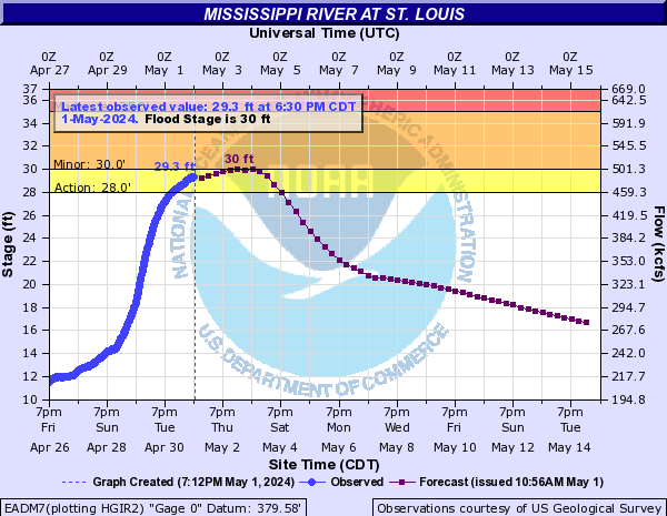
30
Floodwall at Lacledes Landing is closed. Also at this level, the U.S. Coast Guard may prohibit all recreational vessel traffic from just above the Chain of Rocks Canal south entry to just below the mouth of the Meramec River.
25
If the river is rising at this level, the U.S. Coast Guard may restrict the use of recreation vessels from just above the Chain of Rocks Canal south entry to just below the mouth of the Meramec River. Also, southbound tows greater than 600 feet in length, excluding the towboat, should only travel during daylight hours above this height.
18.5
Riverfront parking east of Leonor K. Sullivan Boulevard begins flooding.
Flood Categories (in feet)
Major Flood Stage: 40
Moderate Flood Stage: 35
Flood Stage: 30
Action Stage: 28
Low Stage (in feet): -9999

Historic Crests
(1) 49.58 ft on 08/01/1993
(2) 46.02 ft on 06/09/2019
(3) 43.23 ft on 04/28/1973
(4) 42.52 ft on 01/01/2016
(5) 42.00 ft on 04/01/1785
(6) 41.89 ft on 05/22/1995
(7) 41.70 ft on 05/06/2017
(8) 41.32 ft on 06/27/1844
(9) 40.52 ft on 06/04/2013
(10) 40.30 ft on 07/02/1947
Show More Historic Crests

(P): Preliminary values subject to further review.

Recent Crests
(1) 31.46 ft on 03/21/2021 (P)
(2) 31.94 ft on 06/01/2020
(3) 30.34 ft on 03/25/2020
(4) 30.41 ft on 03/22/2020
(5) 30.59 ft on 01/13/2020
(6) 32.15 ft on 10/13/2019
(7) 46.02 ft on 06/09/2019
(8) 32.63 ft on 10/16/2018
(9) 31.76 ft on 05/25/2017
(10) 41.70 ft on 05/06/2017
Show More Recent Crests

(P): Preliminary values subject to further review.

Low Water Records
(1) -6.20 ft on 01/16/1940
(2) -5.80 ft on 01/26/1963
(3) -5.60 ft on 01/01/1964
(4) -5.50 ft on 12/12/1937
(5) -5.32 ft on 12/26/1989
Show More Low Water Records

Observed and Forecast Stages

Observed Data:
Date (UTC)
Stage
Flow
04/16 08:30
10.33 ft
198 kcfs
04/16 08:00
10.35 ft
199 kcfs
04/16 07:30
10.31 ft
198 kcfs
04/16 07:00
10.36 ft
199 kcfs
04/16 06:30
10.37 ft
199 kcfs
04/16 06:00
10.36 ft
199 kcfs
04/16 05:30
10.35 ft
199 kcfs
04/16 05:00
10.36 ft
199 kcfs
04/16 04:30
10.32 ft
198 kcfs
04/16 04:00
10.38 ft
199 kcfs
04/16 03:30
10.37 ft
199 kcfs
04/16 03:00
10.38 ft
199 kcfs
04/16 02:30
10.37 ft
199 kcfs
04/16 02:00
10.41 ft
199 kcfs
04/16 01:30
10.42 ft
199 kcfs
04/16 01:00
10.42 ft
199 kcfs
04/16 00:30
10.45 ft
200 kcfs
04/16 00:00
10.47 ft
200 kcfs
04/15 23:30
10.44 ft
200 kcfs
04/15 23:00
10.43 ft
200 kcfs
04/15 22:30
10.49 ft
200 kcfs
04/15 22:00
10.49 ft
200 kcfs
04/15 21:30
10.52 ft
201 kcfs
04/15 21:00
10.48 ft
200 kcfs
04/15 20:30
10.52 ft
201 kcfs
04/15 20:00
10.54 ft
201 kcfs
04/15 19:30
10.58 ft
201 kcfs
04/15 19:00
10.52 ft
201 kcfs
04/15 18:30
10.6 ft
202 kcfs
04/15 18:00
10.63 ft
202 kcfs
04/15 17:30
10.61 ft
202 kcfs
04/15 17:00
10.61 ft
202 kcfs
04/15 16:30
10.62 ft
202 kcfs
04/15 16:00
10.64 ft
202 kcfs
04/15 15:30
10.63 ft
202 kcfs
04/15 15:00
10.64 ft
202 kcfs
04/15 14:30
10.62 ft
202 kcfs
04/15 14:00
10.66 ft
202 kcfs
04/15 13:30
10.73 ft
203 kcfs
04/15 13:00
10.67 ft
202 kcfs
04/15 12:30
10.69 ft
203 kcfs
04/15 12:00
10.67 ft
202 kcfs
04/15 11:30
10.73 ft
203 kcfs
04/15 11:00
10.72 ft
203 kcfs
04/15 10:30
10.73 ft
203 kcfs
04/15 10:00
10.73 ft
203 kcfs
04/15 09:30
10.77 ft
203 kcfs
04/15 09:00
10.79 ft
204 kcfs
04/15 08:30
10.8 ft
204 kcfs
04/15 08:00
10.79 ft
204 kcfs
04/15 07:30
10.79 ft
204 kcfs
04/15 07:00
10.78 ft
204 kcfs
04/15 04:30
10.78 ft
204 kcfs
04/15 04:00
10.79 ft
204 kcfs
04/15 03:30
10.8 ft
204 kcfs
04/15 03:00
10.79 ft
204 kcfs
04/15 02:30
10.81 ft
204 kcfs
04/15 02:00
10.82 ft
204 kcfs
04/15 01:30
10.8 ft
204 kcfs
04/15 01:00
10.75 ft
203 kcfs
04/15 00:30
10.8 ft
204 kcfs
04/15 00:00
10.81 ft
204 kcfs
04/14 23:30
10.83 ft
204 kcfs
04/14 23:00
10.78 ft
204 kcfs
04/14 22:30
10.81 ft
204 kcfs
04/14 22:00
10.81 ft
204 kcfs
04/14 21:30
10.84 ft
204 kcfs
04/14 21:00
10.85 ft
204 kcfs
04/14 20:30
10.8 ft
204 kcfs
04/14 20:00
10.78 ft
204 kcfs
04/14 19:30
10.82 ft
204 kcfs
04/14 19:00
10.77 ft
203 kcfs
04/14 18:30
10.79 ft
204 kcfs
04/14 18:00
10.79 ft
204 kcfs
04/14 17:30
10.77 ft
203 kcfs
04/14 17:00
10.74 ft
203 kcfs
04/14 16:30
10.75 ft
203 kcfs
04/14 16:00
10.8 ft
204 kcfs
04/14 15:30
10.8 ft
204 kcfs
04/14 15:00
10.8 ft
204 kcfs
04/14 14:30
10.81 ft
204 kcfs
04/14 14:00
10.83 ft
204 kcfs
04/14 13:30
10.85 ft
204 kcfs
04/14 13:00
10.84 ft
204 kcfs
04/14 12:30
10.85 ft
204 kcfs
04/14 12:00
10.82 ft
204 kcfs
04/14 11:30
10.86 ft
204 kcfs
04/14 11:00
10.85 ft
204 kcfs
04/14 10:30
10.87 ft
205 kcfs
04/14 10:00
10.88 ft
205 kcfs
04/14 09:30
10.9 ft
205 kcfs
04/14 09:00
10.89 ft
205 kcfs
04/14 08:30
10.9 ft
205 kcfs
04/14 08:00
10.9 ft
205 kcfs
04/14 07:30
10.92 ft
205 kcfs
04/14 07:00
10.95 ft
205 kcfs
04/14 06:30
10.94 ft
205 kcfs
04/14 06:00
10.9 ft
205 kcfs
04/14 05:30
10.95 ft
205 kcfs
04/14 05:00
10.92 ft
205 kcfs
04/14 04:30
10.95 ft
205 kcfs
04/14 04:00
10.96 ft
206 kcfs
04/14 03:30
10.93 ft
205 kcfs
04/14 03:00
10.93 ft
205 kcfs
04/14 02:30
11.03 ft
206 kcfs
04/14 02:00
10.97 ft
206 kcfs
04/14 01:30
10.96 ft
206 kcfs
04/14 01:00
10.97 ft
206 kcfs
04/14 00:30
10.97 ft
206 kcfs
04/14 00:00
11.06 ft
207 kcfs
04/13 23:30
11 ft
206 kcfs
04/13 23:00
10.91 ft
205 kcfs
04/13 22:30
10.91 ft
205 kcfs
04/13 22:00
11.01 ft
206 kcfs
04/13 21:30
11.03 ft
206 kcfs
04/13 21:00
11.02 ft
206 kcfs
04/13 20:30
11.03 ft
206 kcfs
04/13 20:00
11.05 ft
207 kcfs
04/13 19:30
11.02 ft
206 kcfs
04/13 19:00
11.04 ft
207 kcfs
04/13 18:30
11.05 ft
207 kcfs
04/13 18:00
11.05 ft
207 kcfs
04/13 17:30
10.99 ft
206 kcfs
04/13 17:00
11.04 ft
207 kcfs
04/13 16:30
11.04 ft
207 kcfs
04/13 16:00
11 ft
206 kcfs
04/13 15:30
11 ft
206 kcfs
04/13 15:00
10.96 ft
206 kcfs
04/13 14:30
11.02 ft
206 kcfs
04/13 14:00
11 ft
206 kcfs
04/13 13:30
11.02 ft
206 kcfs
04/13 13:00
10.98 ft
206 kcfs
04/13 12:30
11 ft
206 kcfs
04/13 12:00
10.99 ft
206 kcfs
04/13 11:30
11.03 ft
206 kcfs
04/13 11:00
11.02 ft
206 kcfs
04/13 10:30
11.02 ft
206 kcfs
04/13 10:00
10.98 ft
206 kcfs
04/13 09:30
10.97 ft
206 kcfs
04/13 09:00
10.98 ft
206 kcfs
04/13 08:30
11 ft
206 kcfs
04/13 08:00
10.98 ft
206 kcfs
04/13 07:30
10.98 ft
206 kcfs
04/13 07:00
10.98 ft
206 kcfs
04/13 06:30
11 ft
206 kcfs
04/13 06:00
11.05 ft
207 kcfs
04/13 05:30
11.12 ft
207 kcfs
04/13 05:00
11.1 ft
207 kcfs
04/13 04:00
11.23 ft
209 kcfs
04/13 03:30
11.3 ft
210 kcfs
04/13 03:00
11.25 ft
209 kcfs
04/13 02:30
11.4 ft
211 kcfs
04/13 02:00
11.41 ft
211 kcfs
04/13 01:30
11.48 ft
212 kcfs
04/13 01:00
11.47 ft
211 kcfs
04/13 00:30
11.43 ft
211 kcfs
04/13 00:00
11.49 ft
212 kcfs
04/12 23:30
11.5 ft
212 kcfs
04/12 23:00
11.52 ft
212 kcfs
04/12 22:30
11.53 ft
212 kcfs
04/12 22:00
11.56 ft
213 kcfs
04/12 21:30
11.58 ft
213 kcfs
04/12 21:00
11.55 ft
212 kcfs
04/12 20:30
11.59 ft
213 kcfs
04/12 20:00
11.6 ft
213 kcfs
04/12 19:30
11.65 ft
214 kcfs
04/12 19:00
11.61 ft
213 kcfs
04/12 18:30
11.6 ft
213 kcfs
04/12 18:00
11.61 ft
213 kcfs
04/12 17:30
11.6 ft
213 kcfs
04/12 17:00
11.59 ft
213 kcfs
04/12 16:30
11.62 ft
213 kcfs
04/12 16:00
11.64 ft
213 kcfs
04/12 15:30
11.63 ft
213 kcfs
04/12 15:00
11.62 ft
213 kcfs
04/12 14:30
11.64 ft
213 kcfs
04/12 14:00
11.67 ft
214 kcfs
04/12 13:30
11.65 ft
214 kcfs
04/12 13:00
11.71 ft
214 kcfs
04/12 12:30
11.7 ft
214 kcfs
04/12 12:00
11.73 ft
215 kcfs
04/12 11:30
11.69 ft
214 kcfs
04/12 11:00
11.72 ft
214 kcfs
04/12 10:30
11.75 ft
215 kcfs
04/12 10:00
11.74 ft
215 kcfs
04/12 09:30
11.79 ft
215 kcfs
04/12 09:00
11.81 ft
215 kcfs
04/12 08:30
11.82 ft
216 kcfs
04/12 08:00
11.84 ft
216 kcfs
04/12 07:30
11.82 ft
216 kcfs
04/12 07:00
11.87 ft
216 kcfs
04/12 06:30
12 ft
218 kcfs
04/12 06:00
11.82 ft
216 kcfs
04/12 05:30
11.93 ft
217 kcfs
04/12 05:00
11.9 ft
217 kcfs
04/12 04:30
11.92 ft
217 kcfs
04/12 04:00
11.9 ft
217 kcfs
04/12 03:30
11.92 ft
217 kcfs
04/12 03:00
11.93 ft
217 kcfs
04/12 02:30
11.95 ft
217 kcfs
04/12 02:00
11.96 ft
217 kcfs
04/12 01:30
11.98 ft
217 kcfs
04/12 01:00
12 ft
218 kcfs
04/12 00:30
11.99 ft
218 kcfs
04/12 00:00
12.01 ft
218 kcfs
04/11 23:30
12.02 ft
218 kcfs
04/11 23:00
12.02 ft
218 kcfs
04/11 22:30
12.02 ft
218 kcfs
04/11 22:00
12.03 ft
218 kcfs
04/11 21:30
12.05 ft
218 kcfs
04/11 21:00
12.01 ft
218 kcfs
04/11 20:30
12.01 ft
218 kcfs
04/11 20:00
12.04 ft
218 kcfs
04/11 19:30
12.03 ft
218 kcfs
04/11 19:00
12.07 ft
219 kcfs
04/11 18:30
12.04 ft
218 kcfs
04/11 18:00
12.04 ft
218 kcfs
04/11 17:30
12.03 ft
218 kcfs
04/11 17:00
12.07 ft
219 kcfs
04/11 16:30
12.07 ft
219 kcfs
04/11 16:00
12.08 ft
219 kcfs
04/11 15:30
12.08 ft
219 kcfs
04/11 14:30
12.09 ft
219 kcfs
04/11 14:00
12.11 ft
219 kcfs
04/11 13:30
12.1 ft
219 kcfs
04/11 13:00
12.09 ft
219 kcfs
04/11 12:30
12.12 ft
219 kcfs
04/11 12:00
12.12 ft
219 kcfs
04/11 11:30
12.12 ft
219 kcfs
04/11 11:00
12.12 ft
219 kcfs
04/11 10:30
12.1 ft
219 kcfs
04/11 10:00
12.13 ft
219 kcfs
04/11 09:30
12.1 ft
219 kcfs
04/11 09:00
12.15 ft
219 kcfs
04/11 08:30
12.08 ft
219 kcfs
04/11 08:00
12.06 ft
218 kcfs
04/11 07:30
12.03 ft
218 kcfs
04/11 07:00
12.01 ft
218 kcfs
04/11 06:30
12.01 ft
218 kcfs
04/11 06:00
11.98 ft
217 kcfs
04/11 05:30
11.99 ft
218 kcfs
04/11 05:00
11.99 ft
218 kcfs
04/11 04:30
11.97 ft
217 kcfs
04/11 04:00
11.98 ft
217 kcfs
04/11 03:30
11.95 ft
217 kcfs
04/11 03:00
11.97 ft
217 kcfs
04/11 02:30
11.98 ft
217 kcfs
04/11 02:00
11.98 ft
217 kcfs
04/11 01:30
12.02 ft
218 kcfs
04/11 01:00
11.99 ft
218 kcfs
04/11 00:30
12.05 ft
218 kcfs
04/11 00:00
12.01 ft
218 kcfs
04/10 23:30
12.05 ft
218 kcfs
04/10 23:00
12.08 ft
219 kcfs
04/10 22:30
12.11 ft
219 kcfs
04/10 22:00
12.13 ft
219 kcfs
04/10 21:30
12.11 ft
219 kcfs
04/10 21:00
12.13 ft
219 kcfs
04/10 20:30
12.17 ft
220 kcfs
04/10 20:00
12.2 ft
220 kcfs
04/10 19:30
12.17 ft
220 kcfs
04/10 19:00
12.19 ft
220 kcfs
04/10 18:30
12.23 ft
220 kcfs
04/10 18:00
12.25 ft
221 kcfs
04/10 17:30
12.27 ft
221 kcfs
04/10 17:00
12.26 ft
221 kcfs
04/10 16:30
12.21 ft
220 kcfs
04/10 16:00
12.25 ft
221 kcfs
04/10 15:30
12.28 ft
221 kcfs
04/10 15:00
12.24 ft
221 kcfs
04/10 14:30
12.27 ft
221 kcfs
04/10 14:00
12.25 ft
221 kcfs
04/10 13:30
12.3 ft
221 kcfs
04/10 13:00
12.31 ft
221 kcfs
04/10 12:30
12.34 ft
222 kcfs
04/10 12:00
12.28 ft
221 kcfs
04/10 11:30
12.29 ft
221 kcfs
04/10 11:00
12.33 ft
222 kcfs
04/10 10:30
12.35 ft
222 kcfs
04/10 10:00
12.31 ft
221 kcfs
04/10 09:30
12.38 ft
222 kcfs
04/10 09:00
12.32 ft
221 kcfs
04/10 08:30
12.22 ft
220 kcfs
04/10 08:00
12.32 ft
221 kcfs
04/10 07:30
12.31 ft
221 kcfs
04/10 07:00
12.3 ft
221 kcfs
04/10 06:30
12.3 ft
221 kcfs
04/10 06:00
12.28 ft
221 kcfs
04/10 05:30
12.28 ft
221 kcfs
04/10 05:00
12.3 ft
221 kcfs
04/10 04:30
12.31 ft
221 kcfs
04/10 04:00
12.34 ft
222 kcfs
04/10 03:30
12.35 ft
222 kcfs
04/10 03:00
12.44 ft
223 kcfs
04/10 02:30
12.52 ft
224 kcfs
04/10 02:00
12.6 ft
225 kcfs
04/10 01:30
12.71 ft
226 kcfs
04/10 01:00
12.78 ft
227 kcfs
04/10 00:30
12.81 ft
227 kcfs
04/10 00:00
12.94 ft
229 kcfs
04/09 23:30
13.04 ft
230 kcfs
04/09 23:00
13.11 ft
231 kcfs
04/09 22:30
13.17 ft
232 kcfs
04/09 22:00
13.22 ft
232 kcfs
04/09 21:30
13.24 ft
233 kcfs
04/09 21:00
13.33 ft
234 kcfs
04/09 20:30
13.34 ft
234 kcfs
04/09 20:00
13.38 ft
234 kcfs
04/09 19:30
13.41 ft
235 kcfs
04/09 19:00
13.41 ft
235 kcfs
04/09 18:30
13.43 ft
235 kcfs
04/09 18:00
13.43 ft
235 kcfs
04/09 17:30
13.5 ft
236 kcfs
04/09 17:00
13.51 ft
236 kcfs
04/09 16:30
13.5 ft
236 kcfs
04/09 16:00
13.56 ft
236 kcfs
04/09 15:30
13.62 ft
237 kcfs
04/09 15:00
13.59 ft
237 kcfs
04/09 14:30
13.6 ft
237 kcfs
04/09 14:00
13.65 ft
238 kcfs
04/09 13:30
13.67 ft
238 kcfs
04/09 13:00
13.71 ft
238 kcfs
04/09 12:30
13.73 ft
239 kcfs
04/09 12:00
13.78 ft
239 kcfs
04/09 11:30
13.77 ft
239 kcfs
04/09 11:00
13.81 ft
240 kcfs
04/09 10:30
13.85 ft
240 kcfs
04/09 10:00
13.84 ft
240 kcfs
04/09 09:30
13.86 ft
240 kcfs
04/09 08:30
13.93 ft
241 kcfs
04/09 08:00
13.92 ft
241 kcfs
04/09 07:30
13.98 ft
242 kcfs
04/09 07:00
13.98 ft
242 kcfs
04/09 06:30
14.03 ft
242 kcfs
04/09 06:00
14.04 ft
242 kcfs
04/09 05:30
14.05 ft
243 kcfs
04/09 05:00
14.08 ft
243 kcfs
04/09 04:30
14.16 ft
244 kcfs
04/09 04:00
14.18 ft
244 kcfs
04/09 03:30
14.19 ft
244 kcfs
04/09 03:00
14.26 ft
245 kcfs
04/09 02:30
14.26 ft
245 kcfs
04/09 02:00
14.32 ft
246 kcfs
04/09 01:30
14.37 ft
247 kcfs
04/09 01:00
14.39 ft
247 kcfs
04/09 00:30
14.48 ft
248 kcfs
04/09 00:00
14.52 ft
248 kcfs
04/08 23:30
14.57 ft
249 kcfs
04/08 23:00
14.61 ft
250 kcfs
04/08 22:30
14.62 ft
250 kcfs
04/08 22:00
14.68 ft
251 kcfs
04/08 21:30
14.71 ft
251 kcfs
04/08 21:00
14.77 ft
252 kcfs
04/08 20:30
14.8 ft
252 kcfs
04/08 20:00
14.79 ft
252 kcfs
04/08 19:30
14.94 ft
254 kcfs
04/08 19:00
14.86 ft
253 kcfs
04/08 18:30
14.92 ft
254 kcfs
04/08 18:00
14.95 ft
254 kcfs
04/08 17:30
14.91 ft
253 kcfs
04/08 17:00
14.98 ft
254 kcfs
04/08 16:30
15 ft
255 kcfs
04/08 16:00
15.03 ft
255 kcfs
04/08 15:30
15.02 ft
255 kcfs
04/08 15:00
15.03 ft
255 kcfs
04/08 14:30
15 ft
255 kcfs
04/08 14:00
15.05 ft
255 kcfs
04/08 13:30
15.06 ft
255 kcfs
04/08 13:00
15.03 ft
255 kcfs
04/08 12:30
15.05 ft
255 kcfs
04/08 12:00
15.06 ft
255 kcfs
04/08 11:30
15.07 ft
256 kcfs
04/08 11:00
15.06 ft
255 kcfs
04/08 10:30
15.12 ft
256 kcfs
04/08 10:00
14.99 ft
254 kcfs
04/08 09:30
15.11 ft
256 kcfs
04/08 09:00
15.1 ft
256 kcfs
04/08 08:30
15.12 ft
256 kcfs
04/08 08:00
15.06 ft
255 kcfs
04/08 07:30
15.11 ft
256 kcfs
04/08 07:00
15.13 ft
256 kcfs
04/08 06:30
15.1 ft
256 kcfs
04/08 06:00
15.15 ft
257 kcfs
04/08 05:30
15.13 ft
256 kcfs
04/08 05:00
15.16 ft
257 kcfs
04/08 04:30
15.13 ft
256 kcfs
04/08 04:00
15.21 ft
257 kcfs
04/08 03:30
15.22 ft
257 kcfs
04/08 03:00
15.24 ft
258 kcfs
04/08 02:30
15.24 ft
258 kcfs
04/08 02:00
15.26 ft
258 kcfs
04/08 01:30
15.29 ft
258 kcfs
04/08 01:00
15.3 ft
258 kcfs
04/08 00:30
15.35 ft
259 kcfs
04/08 00:00
15.36 ft
259 kcfs
04/07 23:30
15.4 ft
260 kcfs
04/07 23:00
15.45 ft
260 kcfs
04/07 22:30
15.44 ft
260 kcfs
04/07 22:00
15.47 ft
261 kcfs
04/07 21:30
15.44 ft
260 kcfs
04/07 21:00
15.48 ft
261 kcfs
04/07 20:30
15.43 ft
260 kcfs
04/07 20:00
15.48 ft
261 kcfs
04/07 19:30
15.48 ft
261 kcfs
04/07 19:00
15.43 ft
260 kcfs
04/07 18:30
15.41 ft
260 kcfs
04/07 18:00
15.4 ft
260 kcfs
04/07 17:30
15.41 ft
260 kcfs
04/07 17:00
15.4 ft
260 kcfs
04/07 16:30
15.31 ft
259 kcfs
04/07 16:00
15.39 ft
260 kcfs
04/07 15:30
15.45 ft
260 kcfs
04/07 15:00
15.4 ft
260 kcfs
04/07 14:30
15.42 ft
260 kcfs
04/07 14:00
15.37 ft
259 kcfs
04/07 13:30
15.38 ft
260 kcfs
04/07 13:00
15.39 ft
260 kcfs
04/07 12:30
15.41 ft
260 kcfs
04/07 12:00
15.38 ft
260 kcfs
04/07 11:30
15.38 ft
260 kcfs
04/07 11:00
15.34 ft
259 kcfs
04/07 10:30
15.44 ft
260 kcfs
04/07 10:00
15.39 ft
260 kcfs
04/07 09:30
15.37 ft
259 kcfs
04/07 09:00
15.41 ft
260 kcfs
04/07 08:30
15.39 ft
260 kcfs
04/07 08:00
15.37 ft
259 kcfs
04/07 07:30
15.35 ft
259 kcfs
04/07 07:00
15.38 ft
260 kcfs
04/07 06:30
15.37 ft
259 kcfs
04/07 06:00
15.37 ft
259 kcfs
04/07 05:30
15.37 ft
259 kcfs
04/07 05:00
15.38 ft
260 kcfs
04/07 04:30
15.39 ft
260 kcfs
04/07 04:00
15.38 ft
260 kcfs
04/07 03:30
15.43 ft
260 kcfs
04/07 03:00
15.36 ft
259 kcfs
04/07 02:30
15.38 ft
260 kcfs
04/07 02:00
15.41 ft
260 kcfs
04/07 01:30
15.38 ft
260 kcfs
04/07 01:00
15.43 ft
260 kcfs
04/07 00:30
15.42 ft
260 kcfs
04/07 00:00
15.4 ft
260 kcfs
Forecast Data:
Date (UTC)
Stage
Flow
04/16 12:00
10.3 ft
198 kcfs
04/16 18:00
10.2 ft
197 kcfs
04/17 00:00
10.2 ft
197 kcfs
04/17 06:00
10.2 ft
197 kcfs
04/17 12:00
10.1 ft
196 kcfs
04/17 18:00
10.1 ft
196 kcfs
04/18 00:00
10 ft
195 kcfs
04/18 06:00
10 ft
195 kcfs
04/18 12:00
10 ft
195 kcfs
04/18 18:00
9.9 ft
194 kcfs
04/19 00:00
9.9 ft
194 kcfs
04/19 06:00
9.9 ft
194 kcfs
04/19 12:00
9.9 ft
194 kcfs
04/19 18:00
9.8 ft
193 kcfs
04/20 00:00
9.8 ft
193 kcfs
04/20 06:00
9.8 ft
193 kcfs
04/20 12:00
9.8 ft
193 kcfs
04/20 18:00
9.8 ft
193 kcfs
04/21 00:00
9.8 ft
193 kcfs
04/21 06:00
9.8 ft
193 kcfs
04/21 12:00
9.8 ft
193 kcfs
04/21 18:00
9.8 ft
193 kcfs
04/22 00:00
9.8 ft
193 kcfs
04/22 06:00
9.8 ft
193 kcfs
04/22 12:00
9.7 ft
191 kcfs
04/22 18:00
9.7 ft
191 kcfs
04/23 00:00
9.7 ft
191 kcfs
04/23 06:00
9.6 ft
190 kcfs
04/23 12:00
9.6 ft
190 kcfs
04/23 18:00
9.6 ft
190 kcfs
04/24 00:00
9.5 ft
189 kcfs
04/24 06:00
9.5 ft
189 kcfs
04/24 12:00
9.4 ft
188 kcfs
04/24 18:00
9.4 ft
188 kcfs
04/25 00:00
9.3 ft
187 kcfs
04/25 06:00
9.3 ft
187 kcfs
04/25 12:00
9.2 ft
186 kcfs
04/25 18:00
9.2 ft
186 kcfs
04/26 00:00
9.1 ft
185 kcfs
04/26 06:00
9 ft
184 kcfs
04/26 12:00
9 ft
184 kcfs
04/26 18:00
8.9 ft
182 kcfs
04/27 00:00
8.7 ft
180 kcfs
04/27 06:00
8.6 ft
179 kcfs
04/27 12:00
8.5 ft
178 kcfs
04/27 18:00
8.4 ft
177 kcfs
04/28 00:00
8.3 ft
176 kcfs
04/28 06:00
8.1 ft
173 kcfs
04/28 12:00
8 ft
172 kcfs
04/28 18:00
7.9 ft
171 kcfs
04/29 00:00
7.8 ft
170 kcfs
04/29 06:00
7.6 ft
168 kcfs
04/29 12:00
7.5 ft
167 kcfs
04/29 18:00
7.4 ft
165 kcfs
04/30 00:00
7.3 ft
164 kcfs
Collaborative Agencies Collapse
The National Weather Service prepares its forecasts and other services in collaboration with agencies like the US Geological Survey, US Bureau of Reclamation, US Army Corps of Engineers, Natural Resource Conservation Service, National Park Service, ALERT Users Group, Bureau of Indian Affairs, and many state and local emergency managers across the country. For details, please click here.
NWS Information
National Weather Service
St. Louis Weather Forecast Office
12 Missouri Research Park Drive
St. Charles, MO 63304
(636) 441-8467
Ask Questions/Webmaster
Page last modified: 23-Jun-2020 5:16 PM
Disclaimer
Credits
Glossary
Privacy Policy
About Us
Career Opportunities