Mississippi River At Chester (CHSI2)
Return to TopNOTE: River forecasts for this location take into account past precipitation and the precipitation amounts expected approximately 24 hours into the future from the forecast issuance time.
NOTE: For the latest navigation status update from the U.S. Army Corps of Engineers-St. Louis District,
click here. Flood Stage: 27 Feet
Latest Stage: 13.79
Current Warnings/Statements/Advisories:None currently.
Vertical Datum updated from NGVD29 to NAVD88 by gauge owner.
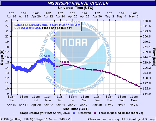
Flood Categories (in feet)
| Major Flood Stage: |
40 |
| Moderate Flood Stage: |
35 |
| Flood Stage: |
27 |
| Action Stage: |
25 |
| Low Stage (in feet): |
-9999 |
Historic Crests
(1) 49.74 ft on 08/07/1993
(2) 46.52 ft on 06/10/2019
(3) 45.99 ft on 01/02/2016
(4) 44.66 ft on 05/06/2017
(5) 44.00 ft on 05/23/1995
(6) 43.32 ft on 04/30/1973
(7) 42.41 ft on 06/05/2013
(8) 41.02 ft on 05/05/1983
(9) 40.58 ft on 05/17/2002
(10) 39.83 ft on 06/30/1844
Show More Historic Crests
(P): Preliminary values subject to further review.
Recent Crests
(1) 31.04 ft on 07/02/2021
(P)
(2) 30.76 ft on 04/14/2021
(P)
(3) 33.88 ft on 03/21/2021
(P)
(4) 33.46 ft on 06/02/2020
(5) 31.71 ft on 04/20/2020
(6) 33.32 ft on 03/25/2020
(7) 27.06 ft on 03/15/2020
(8) 33.07 ft on 01/14/2020
(9) 29.33 ft on 11/03/2019
(10) 33.04 ft on 10/13/2019
Show More Recent Crests
(P): Preliminary values subject to further review.
Low Water Records (1) -4.30 ft on 01/02/1964
(2) -4.20 ft on 12/20/1963
(3) -4.00 ft on 01/03/1900
(4) -3.71 ft on 12/27/1989
(5) -2.60 ft on 01/04/1940
Show More Low Water Records Mississippi River At Cape Girardeau (CPGM7)
Return to TopNOTE: River forecasts for this location take into account past precipitation and the precipitation amounts expected approximately 48 hours into the future from the forecast issuance time.
NOTE: For the latest navigation status update from the U.S. Army Corps of Engineers-St. Louis District,
click here. Flood Stage: 32 Feet
Latest Stage: 19.54
Current Warnings/Statements/Advisories:None currently.
Flood Categories (in feet)
| Major Flood Stage: |
42 |
| Moderate Flood Stage: |
37 |
| Flood Stage: |
32 |
| Action Stage: |
29 |
| Low Stage (in feet): |
5.4 |
Historic Crests
(1) 48.86 ft on 01/02/2016
(2) 48.49 ft on 08/08/1993
(3) 47.00 ft on 05/24/1995
(4) 46.90 ft on 08/03/1993
(5) 46.36 ft on 06/11/2019
Show More Historic Crests
(P): Preliminary values subject to further review.
Recent Crests
(1) 37.83 ft on 03/22/2021
(2) 37.49 ft on 01/15/2020
(3) 46.36 ft on 06/11/2019
(4) 36.82 ft on 10/18/2018
(5) 45.99 ft on 05/07/2017
Show More Recent Crests
(P): Preliminary values subject to further review.
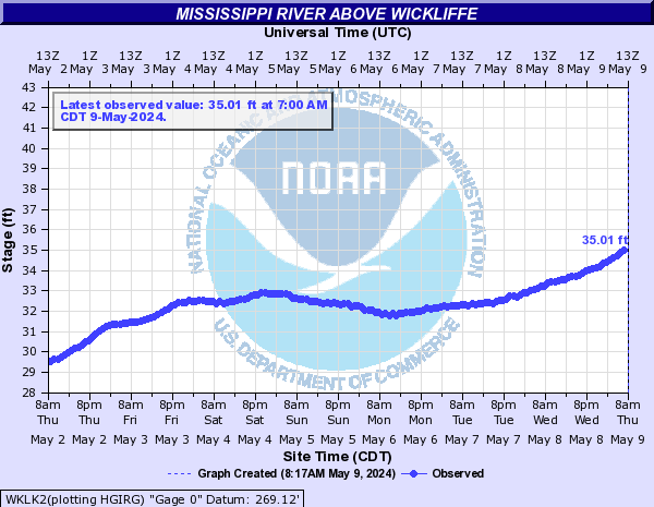
Mississippi River Above Wickliffe (WKLK2)
Return to TopFlood Stage: Not available
Latest Stage: 36.07
Current Warnings/Statements/Advisories:None currently.
Flood Categories (in feet)
| Major Flood Stage: |
0 |
| Moderate Flood Stage: |
0 |
| Flood Stage: |
0 |
| Action Stage: |
0 |
| Low Stage (in feet): |
9.6 |
Historic Crests
Currently none available.
Recent Crests
Currently none available.
Low Water Records
Currently none available.
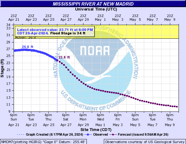
Mississippi River At New Madrid (NMDM7)
Return to TopNOTE: River forecasts for this location take into account past precipitation and the precipitation amounts expected approximately 48 hours into the future from the forecast issuance time.
Flood Stage: 34 Feet
Latest Stage: 25.9
Current Warnings/Statements/Advisories:None currently.
Flood Categories (in feet)
| Major Flood Stage: |
44 |
| Moderate Flood Stage: |
40 |
| Flood Stage: |
34 |
| Action Stage: |
30 |
| Low Stage (in feet): |
-1.2 |
Historic Crests
(1) 48.35 ft on 05/06/2011
(2) 48.00 ft on 02/03/1937
(3) 45.27 ft on 04/29/2011
(4) 44.60 ft on 04/09/1913
(5) 43.60 ft on 04/04/1975
Show More Historic Crests
(P): Preliminary values subject to further review.
Recent Crests
(1) 35.20 ft on 03/09/2022
(2) 35.09 ft on 04/04/2021
(3) 40.17 ft on 04/01/2020
(4) 42.99 ft on 03/02/2019
(5) 41.41 ft on 03/05/2018
Show More Recent Crests
(P): Preliminary values subject to further review.
Mississippi River At Tiptonville (TPTT1)
Return to TopNOTE: River forecasts for this location take into account past precipitation and the precipitation amounts expected approximately 48 hours into the future from the forecast issuance time.
Flood Stage: 0 KCFS
Latest Flow: n/a
Current Warnings/Statements/Advisories:None currently.

Flood Categories (in feet)
| Major Flood Stage: |
47 |
| Moderate Flood Stage: |
45 |
| Flood Stage: |
37 |
| Action Stage: |
34 |
| Low Stage (in feet): |
6 |
Historic Crests
(1) 48.35 ft on 05/05/2011
(2) 47.75 ft on 02/06/1937
(3) 46.00 ft on 05/29/1995
(4) 45.50 ft on 05/10/1983
(5) 45.10 ft on 04/03/1975
(6) 45.03 ft on 03/16/1997
(7) 44.80 ft on 04/03/1973
(8) 44.60 ft on 04/19/1979
(9) 44.56 ft on 01/19/1950
(10) 44.51 ft on 05/21/2002
Show More Historic Crests
(P): Preliminary values subject to further review.
Recent Crests
(1) 44.19 ft on 03/03/2019
(P)
(2) 42.91 ft on 03/05/2018
(3) 41.50 ft on 05/09/2017
(4) 44.06 ft on 01/04/2016
(5) 38.23 ft on 07/08/2015
(6) 32.96 ft on 04/11/2014
(7) 39.22 ft on 05/10/2013
(8) 31.58 ft on 02/05/2012
(9) 48.35 ft on 05/05/2011
(10) 42.72 ft on 03/19/2011
Show More Recent Crests
(P): Preliminary values subject to further review.
Low Water Records (1) -3.22 ft on 09/02/2012
(2) -1.90 ft on 07/13/1988
(3) -1.90 ft on 01/07/1940
(4) -1.70 ft on 10/09/1939
(5) -0.80 ft on 12/15/1937
Show More Low Water Records Mississippi River At Caruthersville (CRTM7)
Return to TopNOTE: River forecasts for this location take into account past precipitation and the precipitation amounts expected approximately 48 hours into the future from the forecast issuance time.
Flood Stage: 32 Feet
Latest Stage: 26.46
Current Warnings/Statements/Advisories:None currently.

Flood Categories (in feet)
| Major Flood Stage: |
43 |
| Moderate Flood Stage: |
41 |
| Flood Stage: |
32 |
| Action Stage: |
29 |
| Low Stage (in feet): |
4 |
Historic Crests
(1) 47.61 ft on 05/07/2011
(2) 46.00 ft on 02/05/1937
(3) 42.66 ft on 01/05/2016
(4) 42.44 ft on 03/03/2019
(P)
(5) 42.40 ft on 04/04/1975
(6) 42.40 ft on 04/03/1973
(7) 42.21 ft on 03/11/1997
(P)
(8) 41.99 ft on 05/28/1995
(9) 41.60 ft on 05/21/2002
(10) 41.56 ft on 04/19/1979
Show More Historic Crests
(P): Preliminary values subject to further review.
Recent Crests
(1) 42.44 ft on 03/03/2019
(P)
(2) 40.90 ft on 03/05/2018
(3) 39.41 ft on 05/10/2017
(4) 42.66 ft on 01/05/2016
(5) 36.29 ft on 07/10/2015
(6) 30.93 ft on 04/11/2014
(7) 37.70 ft on 05/10/2013
(8) 29.93 ft on 02/07/2012
(9) 47.61 ft on 05/07/2011
(10) 40.20 ft on 03/19/2011
Show More Recent Crests
(P): Preliminary values subject to further review.
Low Water Records (1) -2.98 ft on 10/16/2023
(2) -1.82 ft on 10/16/2022
(3) -0.82 ft on 08/30/2012
(4) -0.70 ft on 10/26/1939
(5) -0.70 ft on 01/07/1940
Show More Low Water Records Mississippi River At Osceola (OSGA4)
Return to TopNOTE: River forecasts for this location take into account past precipitation and the precipitation amounts expected approximately 48 hours into the future from the forecast issuance time.
Flood Stage: 28 Feet
Latest Stage: 21.97
Current Warnings/Statements/Advisories:None currently.
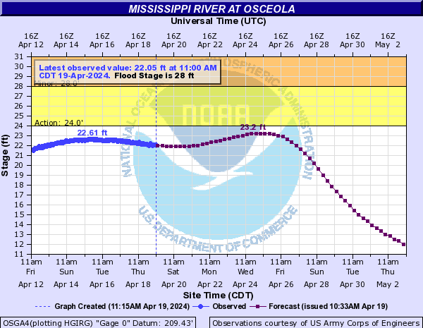
Flood Categories (in feet)
| Major Flood Stage: |
35 |
| Moderate Flood Stage: |
31 |
| Flood Stage: |
28 |
| Action Stage: |
24 |
| Low Stage (in feet): |
-5 |
Historic Crests
(1) 50.90 ft on 02/07/1937
(2) 47.48 ft on 05/08/2011
(3) 45.80 ft on 04/24/1927
(4) 41.20 ft on 05/25/1929
(5) 41.05 ft on 02/20/1950
(6) 40.99 ft on 03/12/1997
(7) 40.90 ft on 04/06/1975
(8) 40.86 ft on 03/04/2019
(P)
(9) 40.60 ft on 04/17/1936
(10) 40.50 ft on 04/06/1945
Show More Historic Crests
(P): Preliminary values subject to further review.
Recent Crests
(1) 40.86 ft on 03/04/2019
(P)
(2) 39.03 ft on 03/07/2018
(3) 35.94 ft on 05/13/2017
(4) 39.67 ft on 01/07/2016
(5) 32.29 ft on 07/11/2015
(6) 26.34 ft on 04/15/2014
(7) 34.22 ft on 05/11/2013
(8) 25.13 ft on 02/06/2012
(9) 47.48 ft on 05/08/2011
(10) 36.99 ft on 03/22/2011
Show More Recent Crests
(P): Preliminary values subject to further review.
Low Water Records (1) -11.80 ft on 10/16/2023
(2) -11.60 ft on 10/16/2022
(3) -10.30 ft on 07/11/1988
(4) -10.00 ft on 01/17/2001
(5) -9.75 ft on 08/13/2012
Show More Low Water Records Mississippi River At Memphis (MEMT1)
Return to TopNOTE: River forecasts for this location take into account past precipitation and the precipitation amounts expected approximately 48 hours into the future from the forecast issuance time.
Flood Stage: 34 Feet
Latest Stage: 21.78
Current Warnings/Statements/Advisories:None currently.
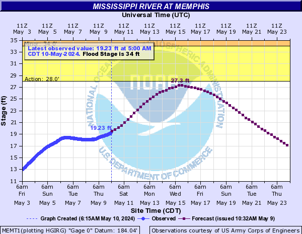
Flood Categories (in feet)
| Major Flood Stage: |
46 |
| Moderate Flood Stage: |
40 |
| Flood Stage: |
34 |
| Action Stage: |
28 |
| Low Stage (in feet): |
-5 |
Historic Crests
(1) 48.70 ft on 02/10/1937
(2) 48.03 ft on 05/10/2011
(3) 45.80 ft on 04/23/1927
(4) 41.37 ft on 03/04/2019
(P)
(5) 40.76 ft on 03/14/1997
(P)
(6) 40.50 ft on 05/08/1973
(7) 40.50 ft on 02/22/1950
(8) 40.32 ft on 03/07/1975
(9) 40.18 ft on 05/22/1961
(10) 39.59 ft on 01/08/2016
Show More Historic Crests
(P): Preliminary values subject to further review.
Recent Crests
(1) 41.37 ft on 03/04/2019
(P)
(2) 39.44 ft on 03/09/2018
(3) 35.99 ft on 05/14/2017
(4) 39.59 ft on 01/08/2016
(5) 32.12 ft on 07/15/2015
(6) 26.24 ft on 04/15/2014
(7) 33.98 ft on 05/11/2013
(8) 24.55 ft on 02/07/2012
(9) 48.03 ft on 05/10/2011
(10) 36.52 ft on 03/22/2011
Show More Recent Crests
(P): Preliminary values subject to further review.
Low Water Records (1) -12.04 ft on 10/17/2023
(2) -10.81 ft on 10/21/2022
(3) -10.70 ft on 07/10/1988
(4) -9.80 ft on 09/19/2012
(5) -9.20 ft on 01/03/2000
Show More Low Water Records Mississippi River At Tunica Riverpark (TRPM6)
Return to TopNOTE: River forecasts for this location take into account past precipitation and the precipitation amounts expected approximately 48 hours into the future from the forecast issuance time.
Flood Stage: 0 KCFS
Latest Flow: n/a
Current Warnings/Statements/Advisories:None currently.

Flood Categories (in feet)
| Major Flood Stage: |
52 |
| Moderate Flood Stage: |
46 |
| Flood Stage: |
41 |
| Action Stage: |
38 |
| Low Stage (in feet): |
9 |
Historic Crests
(1) 58.45 ft on 05/10/2011
(2) 52.57 ft on 03/05/2019
(P)
(3) 51.12 ft on 01/09/2016
(4) 50.69 ft on 03/08/2018
(5) 48.66 ft on 03/22/2011
(6) 47.84 ft on 05/15/2017
(7) 46.83 ft on 04/18/2008
(8) 45.90 ft on 05/12/2013
(9) 44.09 ft on 07/15/2015
(10) 37.69 ft on 04/15/2014
Show More Historic Crests
(P): Preliminary values subject to further review.
Recent Crests
(1) 52.57 ft on 03/05/2019
(P)
(2) 50.69 ft on 03/08/2018
(3) 47.84 ft on 05/15/2017
(4) 51.12 ft on 01/09/2016
(5) 44.09 ft on 07/15/2015
(6) 37.69 ft on 04/15/2014
(7) 45.90 ft on 05/12/2013
(8) 35.86 ft on 02/10/2012
(9) 58.45 ft on 05/10/2011
(10) 48.66 ft on 03/22/2011
Show More Recent Crests
(P): Preliminary values subject to further review.
Low Water Records
Currently none available.
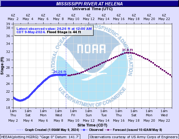
Mississippi River At Helena (HEEA4)
Return to TopNOTE: River forecasts for this location take into account past precipitation and the precipitation amounts expected approximately 48 hours into the future from the forecast issuance time.
Flood Stage: 44 Feet
Latest Stage: 30.14
Current Warnings/Statements/Advisories:None currently.
Flood Categories (in feet)
| Major Flood Stage: |
55 |
| Moderate Flood Stage: |
50 |
| Flood Stage: |
44 |
| Action Stage: |
40 |
| Low Stage (in feet): |
0.5 |
Historic Crests
(1) 60.21 ft on 02/12/1937
(2) 56.75 ft on 04/27/1927
(3) 56.59 ft on 05/12/2011
(4) 55.20 ft on 04/22/1913
(5) 54.30 ft on 04/22/1912
(6) 53.40 ft on 02/11/1916
(7) 53.10 ft on 05/03/1922
(8) 51.75 ft on 04/04/1897
(9) 51.00 ft on 03/26/1903
(10) 50.64 ft on 04/23/1936
Show More Historic Crests
(P): Preliminary values subject to further review.
Recent Crests
(1) 49.65 ft on 03/06/2019
(P)
(2) 47.44 ft on 03/11/2018
(3) 44.79 ft on 05/16/2017
(4) 48.04 ft on 01/10/2016
(5) 41.12 ft on 07/17/2015
(6) 34.19 ft on 04/16/2014
(7) 42.94 ft on 05/13/2013
(8) 32.93 ft on 02/10/2012
(9) 56.59 ft on 05/12/2011
(10) 44.22 ft on 03/25/2011
Show More Recent Crests
(P): Preliminary values subject to further review.
Low Water Records (1) -5.14 ft on 10/18/2023
(2) -4.20 ft on 07/11/1988
(3) -4.08 ft on 10/22/2022
(4) -3.97 ft on 09/21/2012
(5) -3.37 ft on 01/04/2000
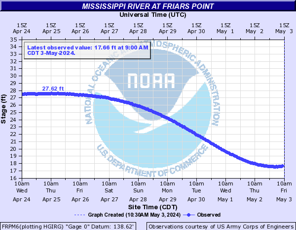
Show More Low Water Records Mississippi River At Friars Point (FRPM6)
Return to TopFlood Stage: Not available
Latest Stage: 27.58
Current Warnings/Statements/Advisories:None currently.
Flood Categories (in feet)
Historic Crests
Currently none available.
Recent Crests
Currently none available.
Low Water Records
Currently none available.
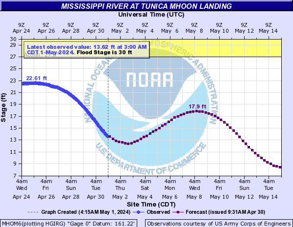
Mississippi River At Tunica Mhoon Landing (MHOM6)
Return to TopNOTE: River forecasts for this location take into account past precipitation and the precipitation amounts expected approximately 48 hours into the future from the forecast issuance time.
Flood Stage: 30 Feet
Latest Stage: 22.28
Current Warnings/Statements/Advisories:None currently.
Flood Categories (in feet)
| Major Flood Stage: |
41 |
| Moderate Flood Stage: |
35 |
| Flood Stage: |
30 |
| Action Stage: |
27 |
| Low Stage (in feet): |
-2 |
Historic Crests
(1) 53.20 ft on 02/10/1937
(2) 43.12 ft on 03/02/1939
(3) 42.00 ft on 02/22/1950
(4) 41.42 ft on 03/05/2019
(P)
(5) 41.00 ft on 05/09/1973
(6) 40.87 ft on 04/08/1945
(7) 40.50 ft on 04/08/1975
(8) 39.00 ft on 04/21/1938
(9) 38.97 ft on 06/06/1943
(10) 38.20 ft on 05/08/1940
Show More Historic Crests
(P): Preliminary values subject to further review.
Recent Crests
(1) 41.42 ft on 03/05/2019
(P)
(2) 36.73 ft on 05/16/2017
(3) 12.80 ft on 01/15/1997
(4) 33.30 ft on 07/03/1996
(5) 26.20 ft on 05/19/1995
(6) 25.39 ft on 05/27/1981
(7) 35.90 ft on 04/04/1978
(8) 25.70 ft on 04/16/1977
(9) 26.50 ft on 03/01/1976
(10) 40.50 ft on 04/08/1975
Show More Recent Crests
(P): Preliminary values subject to further review.
Low Water Records
Currently none available.
Mississippi River Near Arkansas City (ARSA4)
Return to TopNOTE: River forecasts for this location take into account past precipitation and the precipitation amounts expected approximately 48 hours into the future from the forecast issuance time.
Flood Stage: 37 Feet
Latest Stage: 25.81
Current Warnings/Statements/Advisories:None currently.
Flood Categories (in feet)
| Major Flood Stage: |
44 |
| Moderate Flood Stage: |
40 |
| Flood Stage: |
37 |
| Action Stage: |
36 |
| Low Stage (in feet): |
-9999 |
Historic Crests
(1) 59.20 ft on 04/21/1927
(2) 58.80 ft on 05/29/1929
(3) 53.90 ft on 02/14/1937
(4) 53.60 ft on 06/04/1933
(5) 53.50 ft on 02/25/1932
(6) 53.14 ft on 05/16/2011
(7) 51.70 ft on 04/06/1935
(8) 47.80 ft on 01/28/1930
(9) 47.60 ft on 05/11/1973
(10) 47.10 ft on 06/08/1935
Show More Historic Crests
(P): Preliminary values subject to further review.
Recent Crests
(1) 37.78 ft on 03/31/2021
(2) 43.54 ft on 04/10/2020
(3) 43.18 ft on 06/10/2019
(4) 44.77 ft on 03/08/2019
(5) 42.97 ft on 03/14/2018
(6) 42.14 ft on 05/22/2017
(7) 44.32 ft on 01/12/2016
(8) 38.17 ft on 07/21/2015
(9) 53.14 ft on 05/16/2011
(10) 40.40 ft on 05/26/2009
Show More Recent Crests
(P): Preliminary values subject to further review.
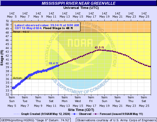
Mississippi River Near Greenville (GEEM6)
Return to TopNOTE: River forecasts for this location take into account past precipitation and the precipitation amounts expected approximately 48 hours into the future from the forecast issuance time.
Flood Stage: 48 Feet
Latest Stage: 37.73
Current Warnings/Statements/Advisories:None currently.
Flood Categories (in feet)
| Major Flood Stage: |
57 |
| Moderate Flood Stage: |
52 |
| Flood Stage: |
48 |
| Action Stage: |
36 |
| Low Stage (in feet): |
10 |
Historic Crests
(1) 65.40 ft on 04/21/1927
(2) 64.22 ft on 05/16/2011
(3) 64.05 ft on 05/30/1929
(4) 63.00 ft on 02/13/1937
(5) 62.80 ft on 04/27/1922
(6) 61.60 ft on 02/11/1916
(7) 61.60 ft on 04/12/1912
(8) 61.20 ft on 04/21/1913
(9) 60.70 ft on 06/03/1908
(10) 59.90 ft on 03/27/1903
Show More Historic Crests
(P): Preliminary values subject to further review.
Recent Crests
(1) 48.83 ft on 03/31/2021
(2) 54.78 ft on 04/13/2020
(3) 51.69 ft on 02/29/2020
(4) 50.04 ft on 01/27/2020
(5) 56.95 ft on 03/12/2019
(6) 47.82 ft on 01/17/2019
(7) 46.29 ft on 04/17/2018
(8) 54.80 ft on 03/14/2018
(9) 54.33 ft on 05/25/2017
(10) 46.39 ft on 03/15/2016
Show More Recent Crests
(P): Preliminary values subject to further review.
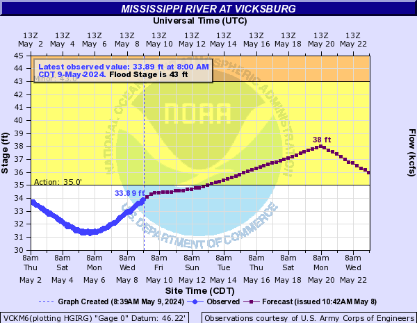
Mississippi River At Vicksburg (VCKM6)
Return to TopNOTE: River forecasts for this location take into account past precipitation and the precipitation amounts expected approximately 48 hours into the future from the forecast issuance time.
Flood Stage: 43 Feet
Latest Stage: 35.74
Flood Categories (in feet)
| Major Flood Stage: |
50 |
| Moderate Flood Stage: |
46 |
| Flood Stage: |
43 |
| Action Stage: |
35 |
| Low Stage (in feet): |
5 |
Historic Crests
(1) 57.10 ft on 05/19/2011
(2) 56.20 ft on 05/04/1927
(3) 53.20 ft on 02/21/1937
(4) 52.80 ft on 06/06/1929
(5) 52.50 ft on 04/28/1922
(6) 51.60 ft on 05/13/1973
(7) 51.50 ft on 02/15/1916
(8) 51.47 ft on 03/12/2019
(9) 51.00 ft on 04/20/2008
(10) 50.46 ft on 04/13/2020
Show More Historic Crests
(P): Preliminary values subject to further review.
Recent Crests
(1) 45.81 ft on 04/15/2021
(2) 50.46 ft on 04/13/2020
(3) 51.47 ft on 03/12/2019
(4) 49.94 ft on 03/15/2018
(5) 48.50 ft on 05/25/2017
(6) 43.32 ft on 03/18/2016
(7) 50.23 ft on 01/15/2016
(8) 37.32 ft on 12/14/2015
(9) 45.96 ft on 07/26/2015
(10) 37.84 ft on 06/08/2015
Show More Recent Crests
(P): Preliminary values subject to further review.
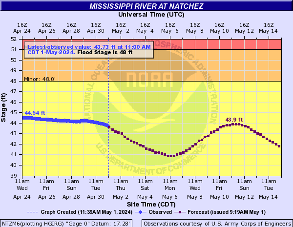
Mississippi River At Natchez (NTZM6)
Return to TopNOTE: River forecasts for this location take into account past precipitation and the precipitation amounts expected approximately 48 hours into the future from the forecast issuance time.
Flood Stage: 48 Feet
Latest Stage: 44.14
Current Warnings/Statements/Advisories:None currently.
Flood Categories (in feet)
| Major Flood Stage: |
57 |
| Moderate Flood Stage: |
51 |
| Flood Stage: |
48 |
| Action Stage: |
38 |
| Low Stage (in feet): |
-9999 |
Historic Crests
(1) 61.95 ft on 05/19/2011
(2) 58.04 ft on 02/21/1937
(3) 57.91 ft on 03/12/2019
(4) 57.55 ft on 04/15/2020
(5) 57.12 ft on 03/18/2018
(6) 57.03 ft on 04/23/2008
(7) 56.75 ft on 01/17/2016
(8) 56.70 ft on 05/13/1973
(9) 56.60 ft on 05/04/1927
(10) 56.30 ft on 03/26/1997
Show More Historic Crests
(P): Preliminary values subject to further review.
Recent Crests
(1) 49.77 ft on 03/19/2022
(2) 52.78 ft on 04/15/2021
(3) 57.55 ft on 04/15/2020
(4) 57.91 ft on 03/12/2019
(5) 57.12 ft on 03/18/2018
(6) 54.91 ft on 05/26/2017
(7) 44.81 ft on 10/17/2016
(8) 51.23 ft on 03/20/2016
(9) 56.75 ft on 01/17/2016
(10) 52.71 ft on 07/27/2015
Show More Recent Crests
(P): Preliminary values subject to further review.
Mississippi River At Old River Low Sill Structure (NOGL1)
Return to TopFlood Stage: Not available
Latest Stage: 49.52
Current Warnings/Statements/Advisories:None currently.
Flood Categories (in feet)
Historic Crests
(1) 63.40 ft on 05/31/1983
(P): Preliminary values subject to further review.
Recent Crests
(1) 63.40 ft on 05/31/1983
(P): Preliminary values subject to further review.
Low Water Records
Currently none available.
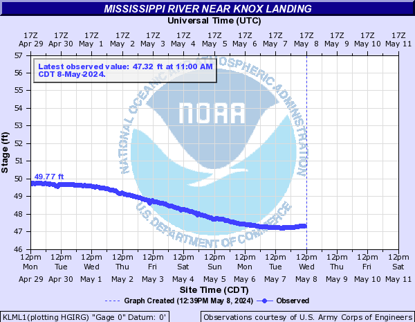
Mississippi River Near Knox Landing (KLML1)
Return to TopFlood Stage: Not available
Latest Stage: 49.7
Current Warnings/Statements/Advisories:None currently.
Flood Categories (in feet)
Historic Crests
(1) 66.26 ft on 05/18/2011
(2) 63.73 ft on 03/25/1997
(3) 63.20 ft on 04/23/2008
(4) 63.15 ft on 05/31/1983
(5) 62.00 ft on 04/23/1979
(6) 61.20 ft on 05/13/1973
(7) 60.45 ft on 05/30/2009
(8) 59.07 ft on 04/14/1975
(9) 58.90 ft on 06/15/1995
(10) 58.70 ft on 05/11/1994
Show More Historic Crests
(P): Preliminary values subject to further review.
Recent Crests
(1) 66.26 ft on 05/18/2011
(2) 60.45 ft on 05/30/2009
(3) 63.20 ft on 04/23/2008
(4) 51.00 ft on 01/28/2007
(5) 57.53 ft on 02/03/2005
(6) 53.86 ft on 06/21/2003
(7) 57.06 ft on 06/06/2002
(8) 55.53 ft on 02/15/1999
(9) 55.12 ft on 05/18/1998
(10) 63.73 ft on 03/25/1997
Show More Recent Crests
(P): Preliminary values subject to further review.
Low Water Records
(1) 8.20 ft on 06/28/1956
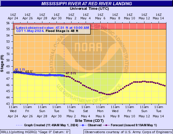
Mississippi River At Red River Landing (RRLL1)
Return to TopNOTE: River forecasts for this location take into account past precipitation and the precipitation amounts expected approximately 24 hours into the future from the forecast issuance time.
Flood Stage: 48 Feet
Latest Stage: 47.45
Flood Categories (in feet)
| Major Flood Stage: |
64 |
| Moderate Flood Stage: |
55 |
| Flood Stage: |
48 |
| Action Stage: |
40 |
| Low Stage (in feet): |
-9999 |
Historic Crests
(1) 63.39 ft on 05/18/2011
(2) 61.94 ft on 03/19/2019
(3) 61.61 ft on 03/24/1997
(4) 61.42 ft on 04/16/2020
(5) 61.22 ft on 03/19/2018
Show More Historic Crests
(P): Preliminary values subject to further review.
Recent Crests
(1) 52.74 ft on 03/23/2022
(2) 49.37 ft on 05/18/2021
(3) 55.92 ft on 04/15/2021
(4) 61.42 ft on 04/16/2020
(5) 61.94 ft on 03/19/2019
Show More Recent Crests
(P): Preliminary values subject to further review.
Low Water Records (1) 2.89 ft on 11/14/1895
(2) 3.24 ft on 11/12/1894
(3) 3.49 ft on 12/15/1872
(4) 3.84 ft on 11/03/1897
(5) 3.95 ft on 11/25/1887
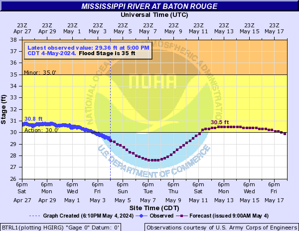
Show More Low Water Records Mississippi River At Baton Rouge (BTRL1)
Return to TopNOTE: River forecasts for this location take into account past precipitation and the precipitation amounts expected approximately 24 hours into the future from the forecast issuance time.
Flood Stage: 35 Feet
Latest Stage: 30.45
Flood Categories (in feet)
| Major Flood Stage: |
40 |
| Moderate Flood Stage: |
38 |
| Flood Stage: |
35 |
| Action Stage: |
30 |
| Low Stage (in feet): |
-9999 |
Historic Crests
(1) 47.28 ft on 05/15/1927
(2) 45.18 ft on 04/29/1945
(3) 45.18 ft on 05/16/1922
(4) 45.01 ft on 05/18/2011
(5) 44.58 ft on 04/16/1945
Show More Historic Crests
(P): Preliminary values subject to further review.
Recent Crests
(1) 35.68 ft on 03/23/2022
(2) 39.09 ft on 04/17/2021
(3) 44.35 ft on 04/16/2020
(4) 44.18 ft on 03/18/2019
(5) 43.78 ft on 03/19/2018
Show More Recent Crests
(P): Preliminary values subject to further review.
Low Water Records (1) -0.07 ft on 11/14/1894
(2) 0.28 ft on 11/16/1895
(3) 0.38 ft on 01/09/1877
(4) 0.48 ft on 01/12/1918
(5) 0.58 ft on 11/26/1887
Show More Low Water Records Mississippi River At Baton Rouge (USGS) (BRML1)
Return to TopFlood Stage: Not available
Latest Stage: 30.87
Current Warnings/Statements/Advisories:None currently.
Flood Categories (in feet)
Historic Crests
(1) 45.48 ft on 05/18/2011
(2) 43.58 ft on 01/18/2016
(3) 43.55 ft on 04/25/2008
(4) 41.00 ft on 06/01/2009
(5) 39.20 ft on 01/20/2019
Show More Historic Crests
(P): Preliminary values subject to further review.
Recent Crests
(1) 39.20 ft on 01/20/2019
(2) 38.74 ft on 03/21/2016
(3) 43.58 ft on 01/18/2016
(4) 38.98 ft on 07/27/2015
(5) 32.57 ft on 04/23/2014
Show More Recent Crests
(P): Preliminary values subject to further review.
Low Water Records (1) 3.43 ft on 10/31/2012
(2) 3.55 ft on 08/02/2012
(3) 4.31 ft on 09/05/2006
(4) 4.81 ft on 10/14/2007
(5) 5.38 ft on 10/28/2013
Show More Low Water Records