Flood ImpactsIf you notice any errors in the below information, please contact our Webmaster
32
Record flooding occurring.
25
House on the left bank and store near the Route 260 bridge starts to flood.
23
Bloomfield Church Road near Little Muskingum River bridge and gage starts to flood.
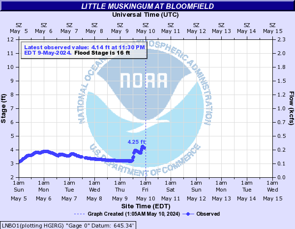
16
Route 26 near the intersection with Route 260 starts to flood between 16 and 20 feet.
12
Hay field across from the gage and between the river and Route 26 starts to flood.
Flood Categories (in feet)
| Major Flood Stage: |
32 |
| Moderate Flood Stage: |
23 |
| Flood Stage: |
16 |
| Action Stage: |
12 |
| Low Stage (in feet): |
-9999 |
Historic Crests
(1) 32.16 ft on 09/18/2004
(2) 30.78 ft on 06/28/1998
(3) 28.30 ft on 03/02/1997
(4) 28.08 ft on 03/05/1963
(5) 26.26 ft on 05/24/1968
(6) 25.84 ft on 01/12/2018
(7) 25.71 ft on 01/12/2005
(8) 25.68 ft on 02/19/2000
(9) 25.22 ft on 02/26/1979
(10) 25.22 ft on 02/13/1966
Show More Historic Crests
(P): Preliminary values subject to further review.
Recent Crests
(1) 19.89 ft on 01/25/2024
(P)
(2) 21.99 ft on 01/10/2024
(P)
(3) 18.60 ft on 03/24/2023
(P)
(4) 18.38 ft on 06/17/2022
(P)
(5) 19.89 ft on 05/07/2022
(P)
(6) 18.84 ft on 02/25/2022
(P)
(7) 20.64 ft on 02/18/2022
(P)
(8) 23.53 ft on 02/04/2022
(P)
(9) 16.57 ft on 03/01/2021
(10) 20.34 ft on 02/13/2020
Show More Recent Crests
(P): Preliminary values subject to further review.
Low Water Records
(1) 1.40 ft on 09/19/2001
(2) 2.58 ft on 08/21/2008