Withlacoochee River Above Valdosta (Skipper Bridge Rd) (VDSG1)
Return to TopNOTE: River forecasts for this location take into account past precipitation and the precipitation amounts expected approximately 48 hours into the future from the forecast issuance time.
Flood Stage: 135 Feet
Latest Stage: 131.05
Vertical datum height surveyed by the USGS
Flood Categories (in feet)
| Major Flood Stage: |
145 |
| Moderate Flood Stage: |
142 |
| Flood Stage: |
135 |
| Action Stage: |
131 |
| Low Stage (in feet): |
122.1 |
Historic Crests
(1) 153.30 ft on 04/04/1948
(2) 146.70 ft on 02/12/1986
(3) 145.90 ft on 04/04/2009
(4) 144.58 ft on 03/08/1984
(5) 142.74 ft on 03/05/1991
Show More Historic Crests
(P): Preliminary values subject to further review.
Recent Crests
(1) 135.47 ft on 03/31/2024
(2) 132.37 ft on 02/18/2024
(3) 135.70 ft on 08/06/2021
(4) 138.72 ft on 01/05/2021
(5) 131.47 ft on 09/22/2020
Show More Recent Crests
(P): Preliminary values subject to further review.
Low Water Records
(1) 121.24 ft on 06/12/2000
(2) 121.34 ft on 08/29/1996
(3) 121.40 ft on 07/16/1988
Withlacoochee River Near Valdosta at US 41 (VDRG1)
Return to TopFlood Stage: 125 Feet
Latest Stage: 123.88
Current Warnings/Statements/Advisories:None currently.
Vertical datum height surveyed by the USGS

Flood Categories (in feet)
| Major Flood Stage: |
137 |
| Moderate Flood Stage: |
133 |
| Flood Stage: |
125 |
| Action Stage: |
123 |
| Low Stage (in feet): |
114 |
Historic Crests
(1) 138.30 ft on 02/12/1986
(2) 132.50 ft on 02/28/2013
(3) 132.41 ft on 03/08/1984
(4) 129.41 ft on 04/04/2016
(5) 129.16 ft on 12/27/2014
(6) 128.45 ft on 12/06/2018
(7) 127.85 ft on 03/15/1980
(8) 127.71 ft on 01/06/2021
(9) 127.54 ft on 02/07/2016
(10) 126.82 ft on 01/25/2017
Show More Historic Crests
(P): Preliminary values subject to further review.
Recent Crests
(1) 125.38 ft on 04/01/2024
(2) 123.89 ft on 02/19/2024
(3) 127.71 ft on 01/06/2021
(4) 123.02 ft on 09/23/2020
(5) 126.13 ft on 03/09/2020
(6) 124.58 ft on 03/02/2020
(7) 126.02 ft on 12/18/2018
(8) 128.45 ft on 12/06/2018
(9) 124.00 ft on 11/20/2018
(10) 126.82 ft on 01/25/2017
Show More Recent Crests
(P): Preliminary values subject to further review.
Low Water Records
Currently none available.
Withlacoochee River Near Quitman (US 84) (QUTG1)
Return to TopNOTE: River forecasts for this location take into account past precipitation and the precipitation amounts expected approximately 48 hours into the future from the forecast issuance time.
Flood Stage: 104 Feet
Latest Stage: 104.21
Vertical datum height surveyed by the USGS
Flood Categories (in feet)
| Major Flood Stage: |
113 |
| Moderate Flood Stage: |
110 |
| Flood Stage: |
104 |
| Action Stage: |
99 |
| Low Stage (in feet): |
85.5 |
Historic Crests
(1) 118.17 ft on 04/05/2009
(2) 115.20 ft on 04/04/1948
(3) 114.98 ft on 03/01/2013
(4) 114.80 ft on 08/19/1928
(5) 114.29 ft on 02/13/1986
Show More Historic Crests
(P): Preliminary values subject to further review.
Recent Crests
(1) 102.26 ft on 04/03/2024
(2) 107.47 ft on 01/08/2021
(3) 105.37 ft on 03/12/2020
(4) 104.73 ft on 12/21/2018
(5) 108.33 ft on 12/07/2018
Show More Recent Crests
(P): Preliminary values subject to further review.
Low Water Records
(1) 84.60 ft on 07/16/1988
(2) 85.03 ft on 06/12/2000
(3) 85.05 ft on 09/18/1999
Withlacoochee River Near Pinetta - CR 150 (in NAVD88) (PINF1)
Return to TopNOTE: River forecasts for this location take into account past precipitation and the precipitation amounts expected approximately 48 hours into the future from the forecast issuance time.
NOTE: Flood stages and impact descriptions for this site are referenced to the NAVD88 datum. Additional datum information can be found at the bottom of this page.
Flood Stage: 73 Feet
Latest Stage: 77.75
Flood Categories (in feet)
| Major Flood Stage: |
83 |
| Moderate Flood Stage: |
79 |
| Flood Stage: |
73 |
| Action Stage: |
59 |
| Low Stage (in feet): |
52.5 |
Historic Crests
(1) 87.84 ft on 04/08/2009
(2) 85.14 ft on 04/05/1948
(3) 83.80 ft on 03/03/2013
(4) 83.48 ft on 03/08/1991
(5) 83.34 ft on 03/03/2013
Show More Historic Crests
(P): Preliminary values subject to further review.
Recent Crests
(1) 64.69 ft on 04/04/2024
(2) 59.69 ft on 02/22/2024
(3) 70.89 ft on 01/10/2021
(4) 65.64 ft on 03/14/2020
(5) 70.31 ft on 12/22/2018
Show More Recent Crests
(P): Preliminary values subject to further review.
Low Water Records
(1) 53.48 ft on 08/23/1955
(2) 53.81 ft on 11/23/1979
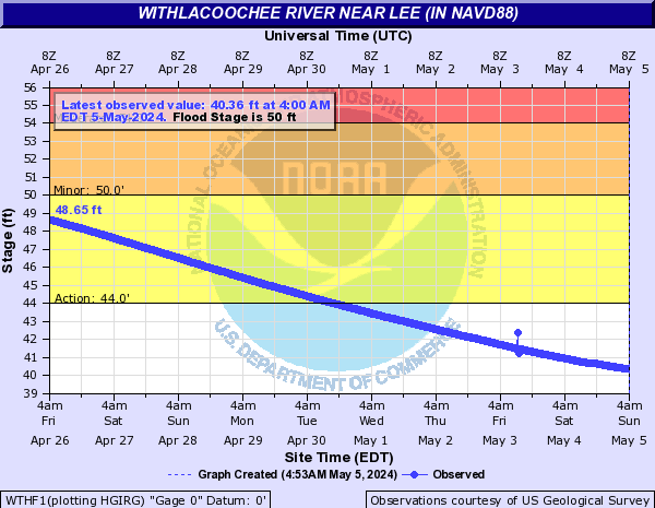
Withlacoochee River Near Lee (in NAVD88) (WTHF1)
Return to TopNOTE: Flood stages and impact descriptions for this site are referenced to the NAVD88 datum. Additional datum information can be found at the bottom of this page.
Flood Stage: 50 Feet
Latest Stage: 54.38
Flood Categories (in feet)
| Major Flood Stage: |
58 |
| Moderate Flood Stage: |
54 |
| Flood Stage: |
50 |
| Action Stage: |
44 |
| Low Stage (in feet): |
29.5 |
Historic Crests
(1) 64.33 ft on 04/10/2009
(2) 57.45 ft on 04/28/2014
(3) 57.16 ft on 03/05/2013
(4) 55.46 ft on 03/16/2003
(5) 53.58 ft on 12/24/2018
Show More Historic Crests
(P): Preliminary values subject to further review.
Recent Crests
(1) 53.58 ft on 12/24/2018
(2) 49.75 ft on 12/11/2018
(3) 43.81 ft on 01/31/2017
(4) 51.82 ft on 04/09/2016
(5) 57.45 ft on 04/28/2014
Show More Recent Crests
(P): Preliminary values subject to further review.
Low Water Records
Currently none available.
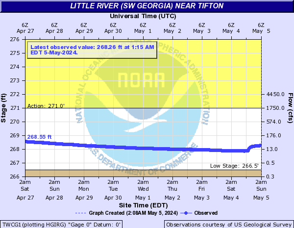
Little River (SW Georgia) Near Tifton (TWCG1)
Return to TopFlood Stage: Not available
Latest Stage: 268.99
Vertical datum height surveyed by the USGS
Flood Categories (in feet)
| Major Flood Stage: |
0 |
| Moderate Flood Stage: |
0 |
| Flood Stage: |
0 |
| Action Stage: |
271 |
| Low Stage (in feet): |
266.5 |
Historic Crests
(1) 272.51 ft on 01/23/2017
(2) 271.98 ft on 02/14/2013
(3) 271.95 ft on 05/05/2010
(4) 271.91 ft on 02/27/2013
(5) 271.76 ft on 12/25/2014
Show More Historic Crests
(P): Preliminary values subject to further review.
Recent Crests
(1) 271.26 ft on 03/29/2024
(2) 271.18 ft on 02/15/2024
(3) 271.65 ft on 03/07/2020
(4) 271.30 ft on 12/04/2018
(5) 272.51 ft on 01/23/2017
Show More Recent Crests
(P): Preliminary values subject to further review.
Low Water Records
Currently none available.
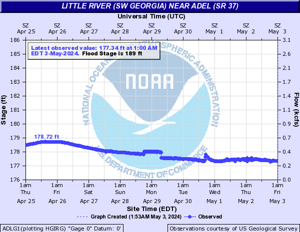
Little River (SW Georgia) Near Adel (SR 37) (ADLG1)
Return to TopFlood Stage: 189 Feet
Latest Stage: 180.45
Current Warnings/Statements/Advisories:None currently.
Vertical datum height surveyed by the USGS
Flood Categories (in feet)
| Major Flood Stage: |
195 |
| Moderate Flood Stage: |
193 |
| Flood Stage: |
189 |
| Action Stage: |
187 |
| Low Stage (in feet): |
175.3 |
Historic Crests
(1) 195.45 ft on 04/04/2009
(2) 194.12 ft on 02/26/2013
(3) 194.10 ft on 04/02/1948
(4) 194.10 ft on 02/12/1986
(5) 193.62 ft on 12/26/2014
Show More Historic Crests
(P): Preliminary values subject to further review.
Recent Crests
(1) 187.66 ft on 03/30/2024
(2) 187.12 ft on 02/16/2024
(3) 189.88 ft on 01/04/2021
(4) 190.79 ft on 03/07/2020
(5) 188.74 ft on 12/17/2018
Show More Recent Crests
(P): Preliminary values subject to further review.
Little River (SW Georgia) Near Hahira (SR 122) (HRAG1)
Return to TopNOTE: River forecasts for this location take into account past precipitation and the precipitation amounts expected approximately 48 hours into the future from the forecast issuance time.
Flood Stage: 151 Feet
Latest Stage: 146.51
Vertical datum height surveyed by the USGS
Flood Categories (in feet)
| Major Flood Stage: |
155 |
| Moderate Flood Stage: |
153 |
| Flood Stage: |
151 |
| Action Stage: |
148 |
| Low Stage (in feet): |
136.5 |
Historic Crests
(1) 156.40 ft on 04/03/1948
(2) 156.01 ft on 08/18/1928
(3) 154.85 ft on 02/28/2013
(4) 153.68 ft on 12/26/2014
(5) 151.49 ft on 04/03/2016
Show More Historic Crests
(P): Preliminary values subject to further review.
Recent Crests
(1) 148.75 ft on 04/01/2024
(2) 148.08 ft on 02/18/2024
(3) 150.40 ft on 01/05/2021
(4) 150.57 ft on 03/09/2020
(5) 149.48 ft on 12/19/2018
Show More Recent Crests
(P): Preliminary values subject to further review.
Low Water Records
Currently none available.
Suwannee River At Ellaville - US 90 (in NAVD88) (ELLF1)
Return to TopNOTE: River forecasts for this location take into account past precipitation and the precipitation amounts expected approximately 48 hours into the future from the forecast issuance time.
NOTE: Flood stages and impact descriptions for this site are referenced to the NAVD88 datum. Additional datum information can be found at the bottom of this page.
Flood Stage: 53 Feet
Latest Stage: 52.47
Flood Categories (in feet)
| Major Flood Stage: |
65 |
| Moderate Flood Stage: |
60 |
| Flood Stage: |
53 |
| Action Stage: |
49 |
| Low Stage (in feet): |
28.5 |
Historic Crests
(1) 67.38 ft on 04/07/1948
(2) 64.25 ft on 04/13/1973
(3) 63.60 ft on 08/20/1928
(4) 63.11 ft on 04/10/2009
(5) 61.07 ft on 02/19/1986
Show More Historic Crests
(P): Preliminary values subject to further review.
Recent Crests
(1) 52.71 ft on 12/24/2018
(2) 48.60 ft on 04/10/2016
(3) 56.23 ft on 04/28/2014
(4) 53.86 ft on 03/07/2013
(5) 63.11 ft on 04/10/2009
Show More Recent Crests
(P): Preliminary values subject to further review.
Low Water Records
(1) 28.70 ft on 11/08/1990
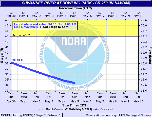
Suwannee River At Dowling Park - CR 250 (in NAVD88) (DOUF1)
Return to TopNOTE: River forecasts for this location take into account past precipitation and the precipitation amounts expected approximately 48 hours into the future from the forecast issuance time.
NOTE: Flood stages and impact descriptions for this site are referenced to the NAVD88 datum. Additional datum information can be found at the bottom of this page.
Flood Stage: 47 Feet
Latest Stage: 43.95
Flood Categories (in feet)
| Major Flood Stage: |
58 |
| Moderate Flood Stage: |
52 |
| Flood Stage: |
47 |
| Action Stage: |
43 |
| Low Stage (in feet): |
21.2 |
Historic Crests
(1) 60.82 ft on 04/08/1948
(2) 56.60 ft on 04/14/1973
(3) 55.72 ft on 08/21/1928
(4) 54.31 ft on 04/12/2009
(5) 53.72 ft on 02/20/1986
Show More Historic Crests
(P): Preliminary values subject to further review.
Recent Crests
(1) 44.85 ft on 12/25/2018
(2) 41.08 ft on 04/10/2016
(3) 54.31 ft on 04/12/2009
(4) 49.89 ft on 04/13/2005
(5) 46.44 ft on 03/18/2003
Show More Recent Crests
(P): Preliminary values subject to further review.
Low Water Records
(1) 21.32 ft on 11/02/2016
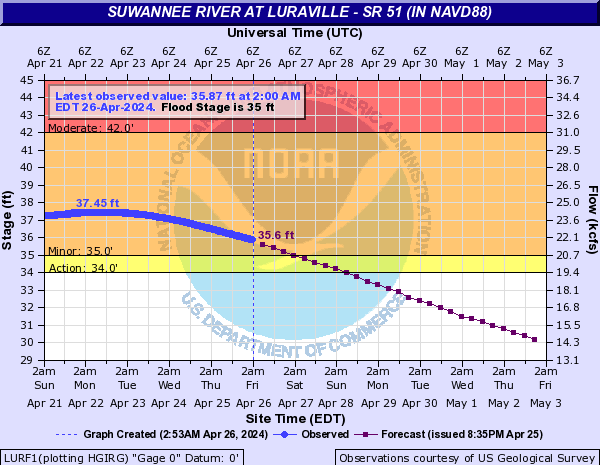
Suwannee River At Luraville - SR 51 (in NAVD88) (LURF1)
Return to TopNOTE: River forecasts for this location take into account past precipitation and the precipitation amounts expected approximately 48 hours into the future from the forecast issuance time.
NOTE: Flood stages and impact descriptions for this site are referenced to the NAVD88 datum. Additional datum information can be found at the bottom of this page.
Flood Stage: 35 Feet
Latest Stage: 36.59
Flood Categories (in feet)
| Major Flood Stage: |
48 |
| Moderate Flood Stage: |
42 |
| Flood Stage: |
35 |
| Action Stage: |
34 |
| Low Stage (in feet): |
16.8 |
Historic Crests
(1) 52.83 ft on 04/08/1948
(2) 49.53 ft on 08/24/1928
(3) 48.77 ft on 04/17/1973
(4) 46.42 ft on 03/20/1998
(5) 46.15 ft on 04/14/2009
Show More Historic Crests
(P): Preliminary values subject to further review.
Recent Crests
(1) 37.81 ft on 12/26/2018
(2) 33.84 ft on 04/11/2016
(3) 41.67 ft on 04/30/2014
(4) 37.14 ft on 03/09/2013
(5) 46.15 ft on 04/14/2009
Show More Recent Crests
(P): Preliminary values subject to further review.
Low Water Records
Currently none available.