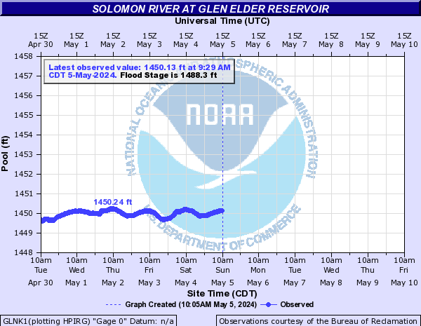
Solomon River At Glen Elder Reservoir (GLNK1)
Return to TopNOTE: River forecasts for this location take into account past precipitation and the precipitation amounts expected approximately 48 hours into the future from the forecast issuance time.
Flood Stage: 1488.3 Feet
Latest Stage: 1449.72
Current Warnings/Statements/Advisories:None currently.
Flood Categories (in feet)
| Major Flood Stage: |
1495 |
| Moderate Flood Stage: |
0 |
| Flood Stage: |
1488.3 |
| Action Stage: |
1478.3 |
| Low Stage (in feet): |
1446.2 |
Historic Crests
Currently none available.
Recent Crests
Currently none available.
Low Water Records
Currently none available.
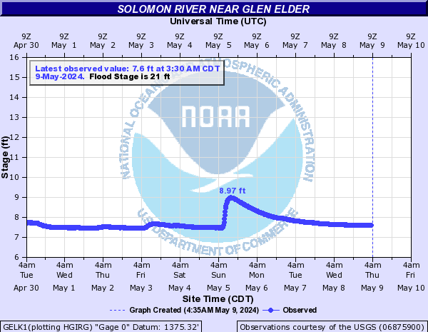
Solomon River Near Glen Elder (GELK1)
Return to TopNOTE: River forecasts for this location take into account past precipitation and the precipitation amounts expected approximately 48 hours into the future from the forecast issuance time.
Flood Stage: 21 Feet
Latest Stage: 7.67
Current Warnings/Statements/Advisories:None currently.
Flood Categories (in feet)
| Major Flood Stage: |
0 |
| Moderate Flood Stage: |
0 |
| Flood Stage: |
21 |
| Action Stage: |
19 |
| Low Stage (in feet): |
-9999 |
Historic Crests
(1) 29.57 ft on 07/22/1993
(2) 28.31 ft on 04/14/1987
(3) 26.89 ft on 07/30/1967
(4) 26.76 ft on 06/02/2011
(5) 25.79 ft on 10/12/1973
Show More Historic Crests
(P): Preliminary values subject to further review.
Recent Crests
(1) 10.43 ft on 07/28/2022
(2) 20.52 ft on 05/28/2021
(3) 17.68 ft on 08/06/2020
(4) 22.13 ft on 08/25/2019
(5) 15.77 ft on 10/10/2018
Show More Recent Crests
(P): Preliminary values subject to further review.
Low Water Records
Currently none available.
Solomon River At Beloit (BLTK1)
Return to TopNOTE: River forecasts for this location take into account past precipitation and the precipitation amounts expected approximately 48 hours into the future from the forecast issuance time.
Flood Stage: 20 Feet
Latest Stage: 2.78
Current Warnings/Statements/Advisories:None currently.
Flood Categories (in feet)
| Major Flood Stage: |
30 |
| Moderate Flood Stage: |
25 |
| Flood Stage: |
20 |
| Action Stage: |
18 |
| Low Stage (in feet): |
-9999 |
Historic Crests
(1) 39.30 ft on 07/13/1951
(2) 36.83 ft on 05/24/1961
(3) 35.87 ft on 06/11/1941
(4) 34.50 ft on 06/02/1935
(5) 34.29 ft on 06/19/1957
Show More Historic Crests
(P): Preliminary values subject to further review.
Recent Crests
(1) 9.49 ft on 05/26/2022
(2) 16.85 ft on 05/28/2021
(3) 22.40 ft on 06/27/2020
(4) 21.48 ft on 06/23/2019
(5) 22.21 ft on 10/10/2018
Show More Recent Crests
(P): Preliminary values subject to further review.
Low Water Records
Currently none available.
Solomon River Near Glasco (GLAK1)
Return to TopNOTE: River forecasts for this location take into account past precipitation and the precipitation amounts expected approximately 24 hours into the future from the forecast issuance time.
Flood Stage: 22 Feet
Latest Stage: 4.25
Current Warnings/Statements/Advisories:None currently.
Flood Categories (in feet)
| Major Flood Stage: |
34 |
| Moderate Flood Stage: |
25 |
| Flood Stage: |
22 |
| Action Stage: |
17 |
| Low Stage (in feet): |
-9999 |
Historic Crests
(1) 40.20 ft on 07/01/1951
(2) 37.40 ft on 06/01/1941
(3) 37.40 ft on 06/12/1951
(4) 36.90 ft on 05/12/1935
(5) 36.22 ft on 05/25/1961
Show More Historic Crests
(P): Preliminary values subject to further review.
Recent Crests
(1) 27.84 ft on 06/27/2020
(2) 25.51 ft on 05/20/2017
(3) 27.75 ft on 06/03/2011
(4) 26.85 ft on 05/27/2011
(5) 32.56 ft on 09/12/2003
Show More Recent Crests
(P): Preliminary values subject to further review.
Low Water Records
Currently none available.
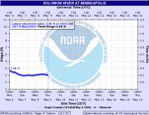
Solomon River At Minneapolis (MPSK1)
Return to TopNOTE: River forecasts for this location take into account past precipitation and the precipitation amounts expected approximately 24 hours into the future from the forecast issuance time.
Flood Stage: 26 Feet
Latest Stage: 2.23
Current Warnings/Statements/Advisories:None currently.
Vertical datum height surveyed by the USGS
Flood Categories (in feet)
| Major Flood Stage: |
38 |
| Moderate Flood Stage: |
30 |
| Flood Stage: |
26 |
| Action Stage: |
21 |
| Low Stage (in feet): |
-9999 |
Historic Crests
(1) 34.10 ft on 07/13/1951
(2) 32.45 ft on 07/21/1993
(3) 31.12 ft on 07/10/1993
(4) 29.18 ft on 07/06/1993
(5) 28.78 ft on 06/03/2011
Show More Historic Crests
(P): Preliminary values subject to further review.
Recent Crests
(1) 10.85 ft on 05/27/2022
(2) 14.32 ft on 05/30/2021
(3) 22.63 ft on 07/28/2020
(4) 25.58 ft on 05/09/2019
(5) 19.57 ft on 05/03/2018
Show More Recent Crests
(P): Preliminary values subject to further review.
Low Water Records
Currently none available.
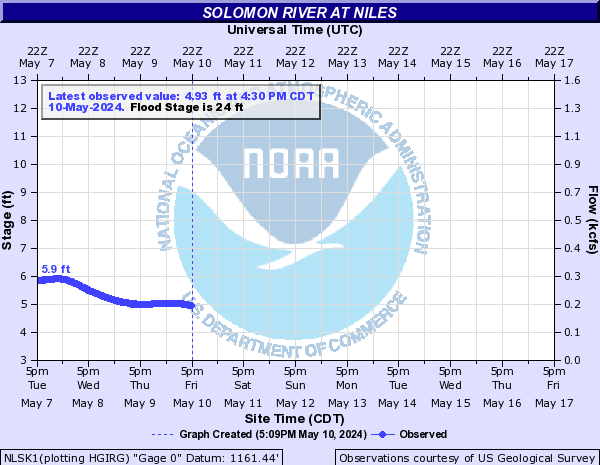
Solomon River At Niles (NLSK1)
Return to TopNOTE: River forecasts for this location take into account past precipitation and the precipitation amounts expected approximately 24 hours into the future from the forecast issuance time.
Flood Stage: 24 Feet
Latest Stage: 3.07
Current Warnings/Statements/Advisories:None currently.
Vertical datum height surveyed by the USGS
Flood Categories (in feet)
| Major Flood Stage: |
34 |
| Moderate Flood Stage: |
28 |
| Flood Stage: |
24 |
| Action Stage: |
19 |
| Low Stage (in feet): |
-9999 |
Historic Crests
(1) 31.76 ft on 07/14/1951
(2) 31.00 ft on 06/21/1951
(3) 30.92 ft on 10/11/1973
(4) 30.38 ft on 09/28/1973
(5) 30.24 ft on 07/22/1993
Show More Historic Crests
(P): Preliminary values subject to further review.
Recent Crests
(1) 15.83 ft on 05/27/2022
(2) 24.48 ft on 05/16/2021
(3) 25.90 ft on 07/30/2020
(4) 25.67 ft on 06/30/2020
(5) 26.90 ft on 08/03/2019
Show More Recent Crests
(P): Preliminary values subject to further review.
Low Water Records
Currently none available.