Flood ImpactsIf you notice any errors in the below information, please contact our Webmaster
17
Water reaches the bottom of the Highway 183 bridge.
14
Water reaches the top of the Highway 183 Bridge piers with water reaching the
13
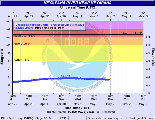
Major Flood Stage. Extensive flooding of agricultural land. Roads and structures along the river may be flooded.
12
Moderate flood stage. Flooding may impact roads and structures along the river. Water may begin to reach the low steel of the bridge.
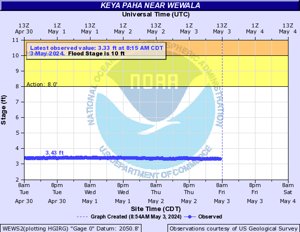
10
Flood stage. Flooding of agricultural land. Near the Highway 183 bridge, flooding mainly occurs along the left bank.
8
Flooding of low lying areas along the river.
Flood Categories (in feet)
| Major Flood Stage: |
13 |
| Moderate Flood Stage: |
12 |
| Flood Stage: |
10 |
| Action Stage: |
8 |
| Low Stage (in feet): |
-9999 |
Historic Crests
(1) 13.50 ft on 03/25/1950
(2) 13.08 ft on 03/31/1952
(3) 10.56 ft on 03/24/1960
(4) 9.90 ft on 03/22/2019
(5) 9.67 ft on 03/04/1994
Show More Historic Crests
(P): Preliminary values subject to further review.
Recent Crests
(1) 4.84 ft on 06/24/2023
(2) 4.13 ft on 05/01/2022
(3) 4.79 ft on 01/25/2022
(4) 3.38 ft on 03/20/2021
(5) 7.32 ft on 06/18/2020
Show More Recent Crests
(P): Preliminary values subject to further review.
Low Water Records
Currently none available.