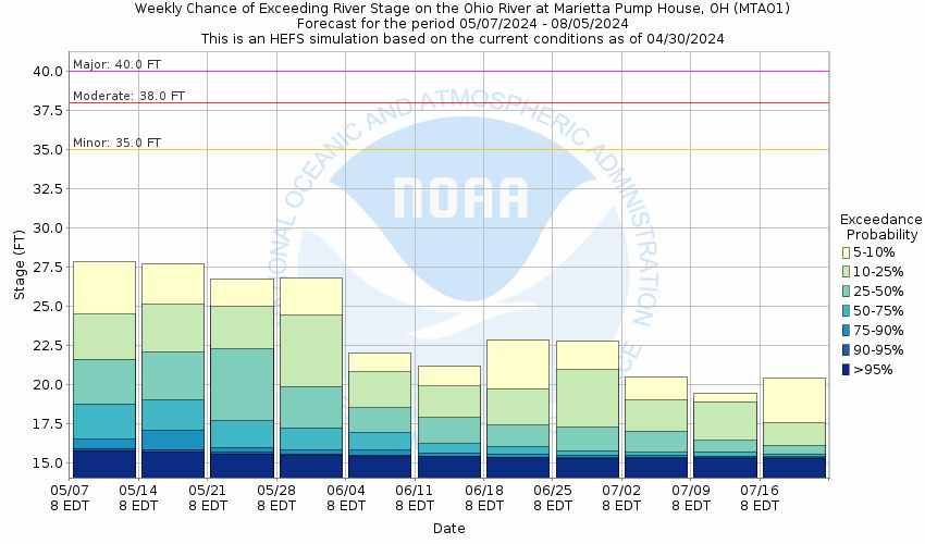
Historic Crests
(1) 58.30 ft on 03/29/1913
(2) 55.00 ft on 01/26/1937
(3) 52.90 ft on 02/07/1884
(4) 50.50 ft on 03/16/1907
(5) 48.80 ft on 02/16/1832
(6) 45.20 ft on 03/12/1964
(7) 45.00 ft on 09/30/1861
(8) 44.97 ft on 09/19/2004
(9) 43.60 ft on 01/08/2005
(10) 41.40 ft on 01/24/1959 Show More Historic Crests
(P): Preliminary values subject to further review.
Recent Crests
(1) 35.35 ft on 09/12/2018
(2) 36.40 ft on 04/05/2018
(3) 39.58 ft on 02/18/2018
(4) 31.18 ft on 03/16/2015
(5) 37.34 ft on 03/13/2011 Show More Recent Crests
(P): Preliminary values subject to further review.
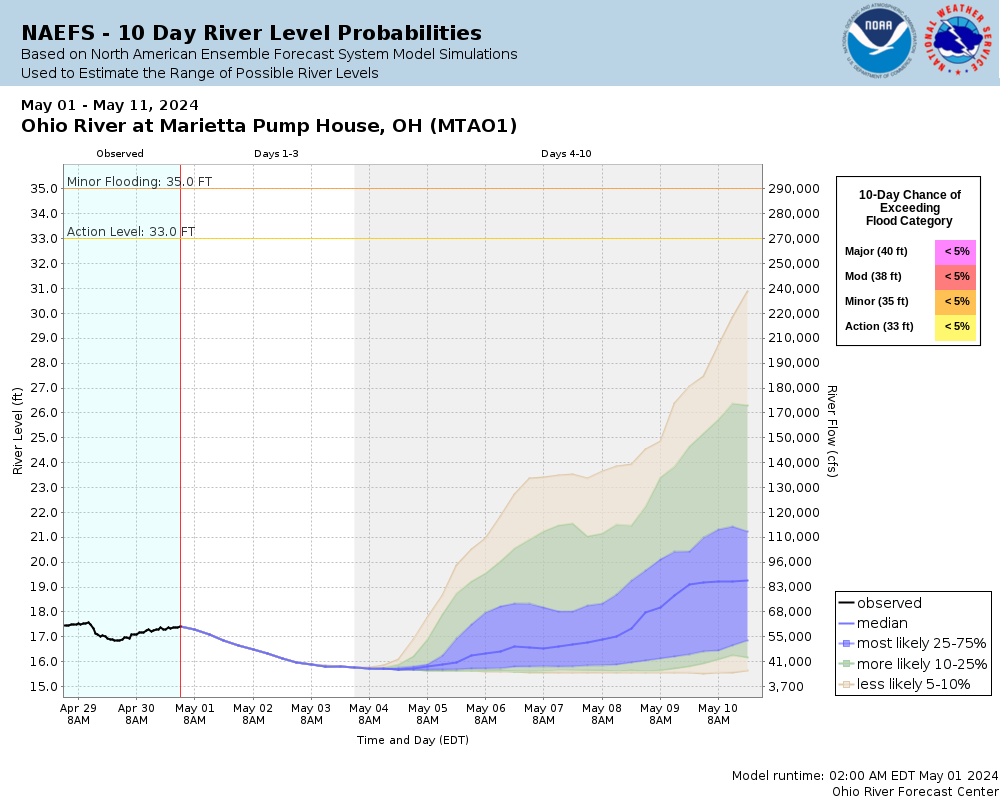
Latitude/Longitude Disclaimer: The gauge location shown in the above map
is the approximate location based on the latitude/longitude coordinates
provided to the NWS by the gauge owner.
Flood Impacts & Photos
If you notice any errors in the below information, please contact our Webmaster
42
Most business, homes, and roads are flooded throughout Marietta at stages 42 feet and above.
41
Several sections and business along Front, Greene, Hart, Butler and Second Streets and Elemwood Avenue are flooded. Portions of Fifth, Buckley, Knox, Fair and Ohio Streets are flooded.
40
Major flooding is occuring. Wayne Street at Eighth Street, Greene Street at Second, Seventh and Pike Streets, Front Street at Monroe Street and at the Armory, Pennsylvania Avenue at Linwood Street and at Eton Street, Second Street at Bbutler Street, and Scammel Street at Second and Third Streets are all flooded. On the West Side, Harmar Street at Maple and Pearl Streets, and Market Street at Fort Square are flooded.
39
Pike street at Lafayette, Greene at Third Street, Jefferson Street at East Eight Street, Third Street between Butler and Church Streets, and Second Street at Wooster Street are all flooded.
38
Elmwood Avenue at Ash, Hart, Pike and Charles Streets at Seventh Street, Church at Second Street, Butler at Fifth Street, Ohio Street at Second and Third Streets are all flooded.
37
Hart Street at Ash and Fourth Streets, Stark and Jefferson Streets at Seventh Street, Fourth Street at Butler Street, Second and Third Streets at Church Street, Spike Streeet at Olney Street, Lafayette and Wayne Streets at Eighth Street, Greene Street at Fifth and Sixth Streets are flooded.
36
Pike Street at the entrance to Phillips Elementary School, Elmwood Avenue and Hart Street start to flood. Eighth at Ohio and Stark Streets start to flood. Second and Third Streets between Green and Butler floods.
35
Stark Street at 7th Street, Pike Street at Wayne, Elmwood Avenue and Greene Street at the center of Don Drumm Field are flooded.
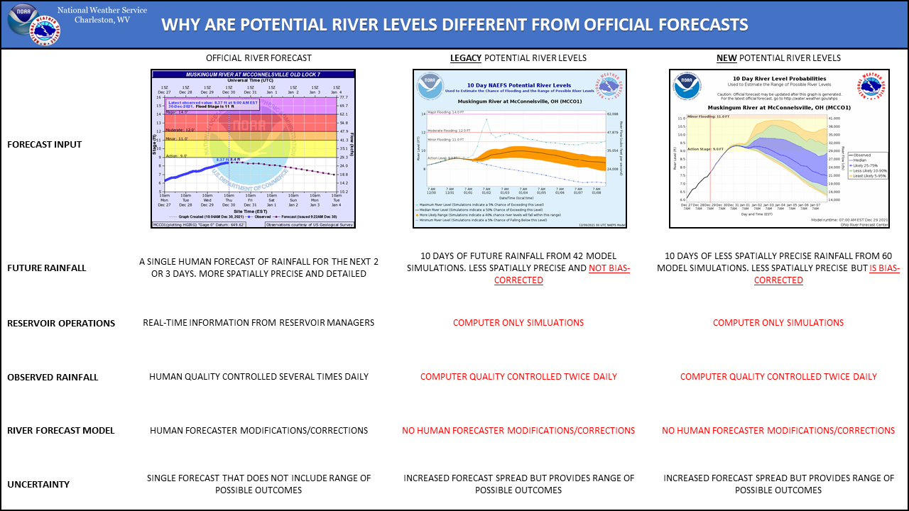
The National Weather Service prepares its forecasts and other services in collaboration with agencies like the US Geological Survey, US Bureau of Reclamation, US Army Corps of Engineers, Natural Resource Conservation Service, National Park Service, ALERT Users Group, Bureau of Indian Affairs, and many state and local emergency managers across the country. For details, please click here.
NWS Information
National Weather Service
Charleston Weather Forecast Office
1754 Hendrickson Drive
South Charleston, WV 25303
(304) 356-5885 Ask Questions/Webmaster
Page last modified: 2-Nov-2020 7:30 PM


