Skip Navigation Link weather.gov  
NOAA logo - Click to go to the NOAA homepage National Weather Service NWS logo - Click to go to the NWS homepage
Advanced Hydrologic Prediction Service
Image background of Navigation bar Left
Navigation Bar End Cap


This probabilistic forecast is issued by the West Gulf River Forecast Center.
tab left off Hydrograph tab right off tab left off River at a Glance tab right off tab left off Download tab right off tab left on tab right on
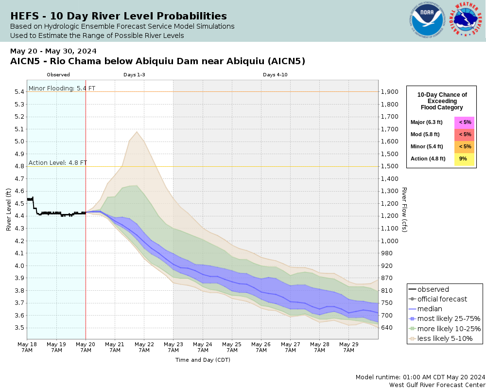
Experimental Short Range Forecast Uncertainty (AHPS) - External Links: Product Description Document | Customer Survey
About this graph
Forecasts for the Rio Chama below Abiquiu are issued as needed during times of high water, but are not routinely available.
Return to Area Map

Upstream Gauge - above Abiquiu Upstream Gauge Downstream Gauge Downstream Gauge - near Chamita
Zoom Level:16
Flood Categories (in feet)
Major Flood Stage: 6.3
Moderate Flood Stage: 5.8
Flood Stage: 5.4
Action Stage: 4.8
Low Stage (in feet): 0

Historic Crests
(1) 5.52 ft on 05/14/1985
(2) 5.45 ft on 06/12/1970
(3) 5.16 ft on 04/25/1989
(4) 5.01 ft on 06/28/1995
(5) 4.83 ft on 05/15/2004
(6) 4.82 ft on 04/27/2010
(7) 4.80 ft on 05/29/1998
(8) 4.80 ft on 04/19/2005
(9) 4.76 ft on 04/16/2008
(10) 4.73 ft on 05/29/2009
Show More Historic Crests

(P): Preliminary values subject to further review.

Recent Crests
(1) 4.51 ft on 06/06/2011
(2) 4.82 ft on 04/27/2010
(3) 4.73 ft on 05/29/2009
(4) 4.76 ft on 04/16/2008
(5) 4.70 ft on 05/17/2007
(6) 4.80 ft on 04/19/2005
(7) 4.83 ft on 05/15/2004
(8) 4.80 ft on 05/29/1998
(9) 5.01 ft on 06/28/1995
(10) 5.16 ft on 04/25/1989
Show More Recent Crests

(P): Preliminary values subject to further review.

Low Water Records
Currently none available.
KML Image
Gauge LocationGauge Map Marker
Disclaimer
Latitude/Longitude Disclaimer: The gauge location shown in the above map is the approximate location based on the latitude/longitude coordinates provided to the NWS by the gauge owner.
Flood Impacts & Photos Collapse
If you notice any errors in the below information, please contact our Webmaster
5.4 Initial flood stage. Approximately 1900cfs Farms and properties along the river will see overbank flooding and encroachemnt of water into low lying areas. If Rio Ojo Caliente is running at 550cfs or greater properties near the confluence with Rio Chama will see overbank flooding, bank erosion and impacts to structures immediately adjacent to the river. Fishing spots and picnic areas below Abiquiu Dam will be inaccessible.
4.8 Bankfull Stage. Approximately 1460 cfs. Houses near Highway 84 along river will see water begin to encroach their yards. Cattle that cross the river at lower flows may be trapped on one side or the other. If flows out of the Rio Ojo Caliente are 550 cfs or higher properties near and below the confluence with the Rio Chama may encroachment of water onto land immediately adjacent to the river along with bank erosion.

Other Real-time and/or Archive Data Sources:

Collaborative Agencies Collapse
The National Weather Service prepares its forecasts and other services in collaboration with agencies like the US Geological Survey, US Bureau of Reclamation, US Army Corps of Engineers, Natural Resource Conservation Service, National Park Service, ALERT Users Group, Bureau of Indian Affairs, and many state and local emergency managers across the country. For details, please click here.
NWS Information
National Weather Service
Albuquerque Weather Forecast Office
2341 Clark Carr Loop SE
Albuquerque, NM 87106
(505) 243-0702
Ask Questions/Webmaster
Page last modified: 2-Nov-2020 7:28 PM
Disclaimer
Credits
Glossary
Privacy Policy
About Us
Career Opportunities