Skip Navigation Link weather.gov  
NOAA logo - Click to go to the NOAA homepage National Weather Service NWS logo - Click to go to the NWS homepage
Advanced Hydrologic Prediction Service
Image background of Navigation bar Left
Navigation Bar End Cap


This probabilistic forecast is issued by the Southeast River Forecast Center.
tab left off Hydrograph tab right off tab left off River at a Glance tab right off tab left off Download tab right off tab left on tab right on
About this graph
Forecasts for the Catoma Creek near Montgomery are issued as needed during times of high water, but are not routinely available.
Return to Area Map

Zoom Level:14
Flood Categories (in feet)
Major Flood Stage: 28
Moderate Flood Stage: 24
Flood Stage: 20
Action Stage: 17
Low Stage (in feet): -9999

Historic Crests
(1) 29.78 ft on 03/17/1990
(2) 28.60 ft on 02/25/1961
(3) 28.13 ft on 02/17/1975
(4) 27.20 ft on 03/04/2001
(5) 27.14 ft on 03/28/2005
Show More Historic Crests

(P): Preliminary values subject to further review.

Recent Crests
(1) 22.80 ft on 03/10/2024 (P)
(2) 26.00 ft on 02/13/2024 (P)
(3) 20.24 ft on 01/11/2024 (P)
(4) 23.36 ft on 02/05/2022
(5) 24.57 ft on 12/29/2017
Show More Recent Crests

(P): Preliminary values subject to further review.

Low Water Records
Currently none available.
KML Image
Gauge LocationGauge Map Marker
Disclaimer
Latitude/Longitude Disclaimer: The gauge location shown in the above map is the approximate location based on the latitude/longitude coordinates provided to the NWS by the gauge owner.
Flood Impacts & Photos Collapse
If you notice any errors in the below information, please contact our Webmaster
33 Flood waters reach I 65 and flooding of the interstate will occur as water levels rise above this stage.
32.7 The CSX railroad bridge between Wells Road and Old Selma Road will begin to flood.
30 The CSX railroad bridge just west of US 31 will begin to flood as water rises above 30 feet.
29 Water reaches the US 31 bridge at Catoma Creek and the road begins to flood. Water begins to overflow US 331 near the bridge crossing over Catoma Creek as water rises above 29 feet.
28 Considerable residential and street flooding occurs in the the vicinity of Old Selma and Hayneville Roads. Water overflows the bridge on Old Selma Road as water rises above 28 feet. Residential flooding occurs along Grovewood Drive and Fleming Road. Industrial and commercial flooding also occurs along the Mobile-Selma Highway and Interstate 65.
27.5 The CSX railway will begin to flood in the vicinity of the bridge next to US 331 as water rises above 27.5 feet.
24 Residential and street flooding becomes a problem...and increases rapidly above 24 feet. Several residences are threatened.
20 Flooding of agricultural lands in the vicinity of the U.S. 331 Highway Bridge occurs.

Other Real-time and/or Archive Data Sources:

Additional Information Collapse
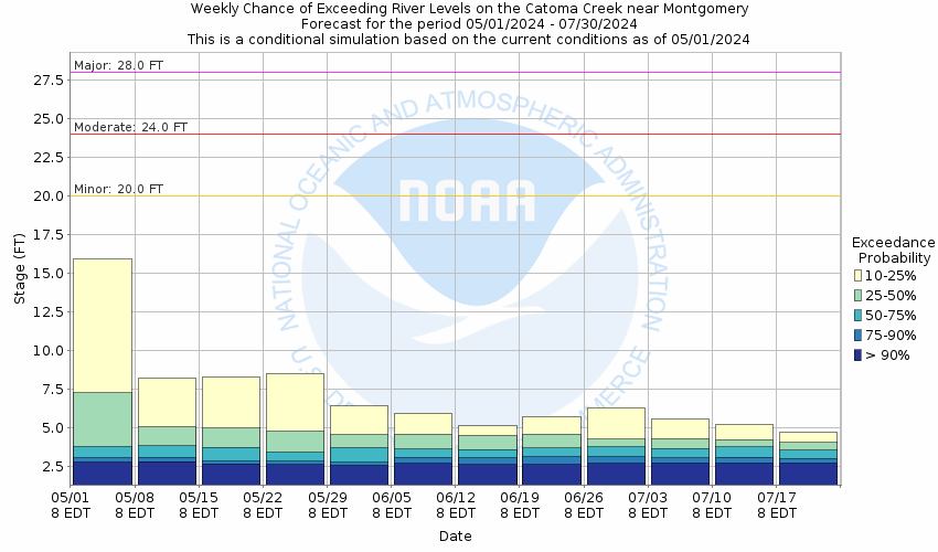
Potential River Levels - Used to
Potential River Levels
Used to Estimate the Chance of Flooding and the Range of Possible River Levels
10 Day (HEFS) 7 Day (NAEFS) 7 Day (GEFS)
HEFS Ensemble NAEFS Ensemble GEFS Ensemble

Note: Use the official hydrograph at the top of this web page for river levels within the next 72 Hours.

Collaborative Agencies Collapse
The National Weather Service prepares its forecasts and other services in collaboration with agencies like the US Geological Survey, US Bureau of Reclamation, US Army Corps of Engineers, Natural Resource Conservation Service, National Park Service, ALERT Users Group, Bureau of Indian Affairs, and many state and local emergency managers across the country. For details, please click here.
NWS Information
National Weather Service
Birmingham Weather Forecast Office
465 Weathervane Road
Calera, AL 35040-5427
(205) 664-3010
Ask Questions/Webmaster
Page last modified: 2-Nov-2020 7:29 PM
Disclaimer
Credits
Glossary
Privacy Policy
About Us
Career Opportunities