Forecasts for the Spicket River near Methuen are issued as needed during times of high water, but are not routinely available.Vertical datum height surveyed by the USGS
Historic Crests
(1) 12.15 ft on 05/16/2006
(2) 9.86 ft on 03/16/2010
(3) 9.13 ft on 04/01/2010
(4) 9.07 ft on 03/24/2001
(5) 9.01 ft on 04/18/2007 Show More Historic Crests
(P): Preliminary values subject to further review.
Recent Crests
(1) 8.14 ft on 04/01/2014
(2) 9.13 ft on 04/01/2010
(3) 9.86 ft on 03/16/2010
(4) 8.53 ft on 02/27/2010
(5) 7.02 ft on 03/09/2008 Show More Recent Crests
(P): Preliminary values subject to further review.
Latitude/Longitude Disclaimer: The gauge location shown in the above map
is the approximate location based on the latitude/longitude coordinates
provided to the NWS by the gauge owner.
Flood Impacts & Photos
If you notice any errors in the below information, please contact our Webmaster
14
This is a dangerous, major flood in Salem, Methuen and Lawrence. In Salem, affected areas include Haigh St, Bluff St Ext, Main St, Hampshire Rd, Fiedler Ave, Linwood Ave and Mulberry Rd. In Methuen, affected areas include Horne St, Morrison Ct, Broadway, Gleason St, East River Place, and Pine St. This river inundates numerous roadways and homes in Lawrence within the vicinity of Route 28 and Daisy St, through Erving Ave and Myrtle St. Flooding occurs at the Mary Immaculate Nursing Home.
13.2
This is the maximum reportable stage at the Spicket River gage. In Salem, flooding occurs on Haigh St, Main St, Bluff St Ext, Hampshire Rd, Linwood Ave, Mulberry Rd and Fiedler Ave. In Methuen, affected areas include Horne St, Morrison Ct, Broadway, Gleason St, Pine St, and East River Place. In Lawrence, numerous homes in the general vicinity of Holly St, Park St, Myrtle St and Erving Ave will be inundated. Floodwaters will reach the Mary Immaculate Nursing Home.
12
This is a dangerous, major flood in Salem, Methuen and Lawrence. In Salem, flooding occurs on Haigh St, Main St, Bluff St Ext, Hampshire Rd, Linwood Ave, Mulberry Rd and Fiedler Ave. In Methuen, affected areas include Horne St, Morrison Court, Broadway, Gleason St, Pine St, and East River Place. In Lawrence, numerous homes in the general vicinity of Holly St, Park St, Myrtle St and Erving Ave will be innundated. Floodwaters reach the Mary Immaculate Nursing Home.
11
In Salem the following locations are affected, Haigh St, Main St, Bluff St Ext, Hampshire Rd, Mulberry Rd, Fiedler Ave and Linwood Ave. In Methuen, floodwaters affect the following locations, Horne St, Pine St, Gleason St, Morrison Court, Broadway, and East River Place. In Lawrence, locations impacted include the general vicinity of Park St to Broadway St, Erving Avenue and some nearby streets. Flooding is also expected further down river on Haverhill St, Access Rd, and Garden St.
10
Moderate flooding occurs along the Spicket in Salem, Methuen and Lawrence. In Salem the following streets and/or low lying properties along those streets are affected, Haigh and Main St, Bluff St Ext, and Fiedler Ave. In Methuen, floodwaters affect the lowest lying homes and properties on Horne St, Gleason St, Morrison Court and Broadway. In Lawrence flooded areas include but are not limited to, Berving Ave, Spruce St, Saratoga St and Short St. Homes are affected on Myrtle and Willow.
9
In Salem, the lower ends of Haigh St, Bluff St Extension and lowest lying properties on Fiedler Ave are impacted. Main St floods by the river. In Methuen, floodwaters affect the following locations, Horne, Pine and Gleason Streets, Morrison Court, Broadway, and East River Place. In Lawrence, floodwaters affect the following locations, Erving Avenue, Spruce, Saratoga, Myrtle and Willow Streets, and Schofield Park.
8.5
In Salem, floodwaters encroach on lowest lying properties on Fiedler Ave. In Methuen, floodwaters encroach near properties on Horne Street, Morrison Court, and Broadway. In Lawrence, the river inundates Schofield Park and spreads onto Saratoga Street. Floodwaters reach onto Willow Street as well as nearby low lying buildings in the vicinity of Willow and Myrtle streets. In addition, floodwaters begin to inundate Spruce Street around the bridge.
8
Water backs up behind the Hampshire Road Bridge at the Methuen and Salem line. Floodwaters encroach on lowest lying properties on Fiedler Avenue in Salem. In Lawrence, floodwaters reach onto Willow Street as well as nearby low lying buildings in the vicinity of Willow and Myrtle Streets. Floodwaters begin ponding onto Spruce Street around the bridge. Schofield Park begins to flood, and floodwaters begin to spread onto nearby Saratoga Street.
7.5
Minor flooding of several parking areas along the river is possible as water from the Spicket River backs up into storm drains. Water begins to back up behind the Hampshire Road Bridge at the Methuen and Salem town line. Floodwaters encroach on lowest lying properties on Fiedler Ave in Salem.
Potential River Levels Used to Estimate the Chance of Flooding and
the Range of Possible River Levels
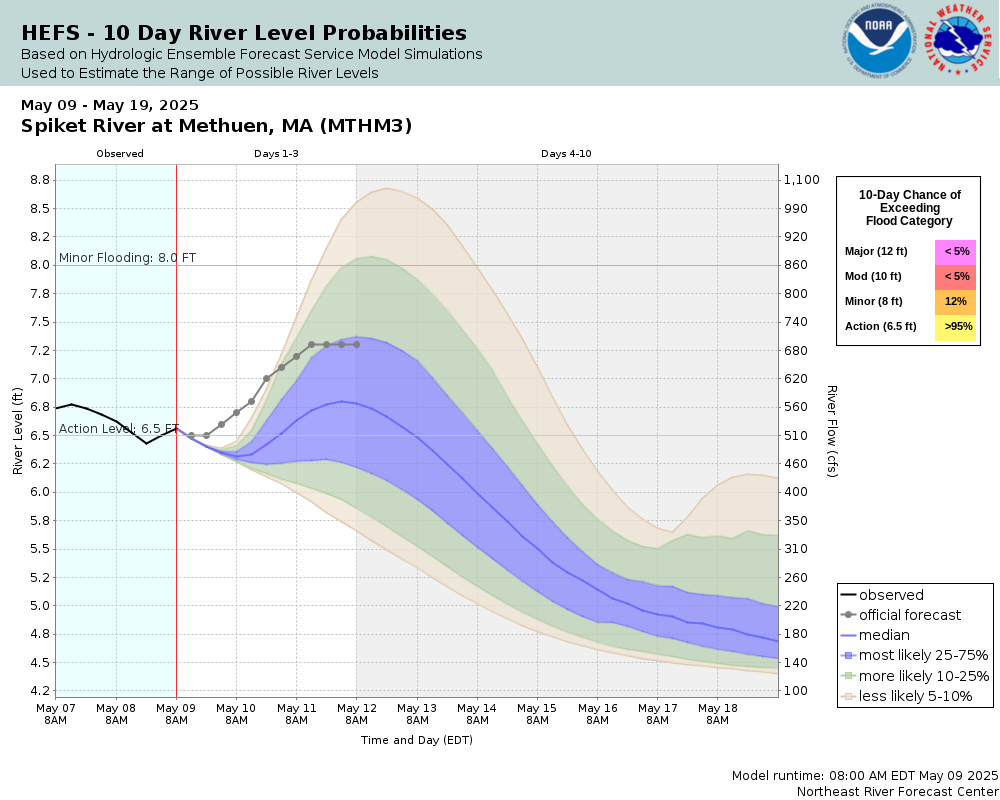
10 Day (HEFS)
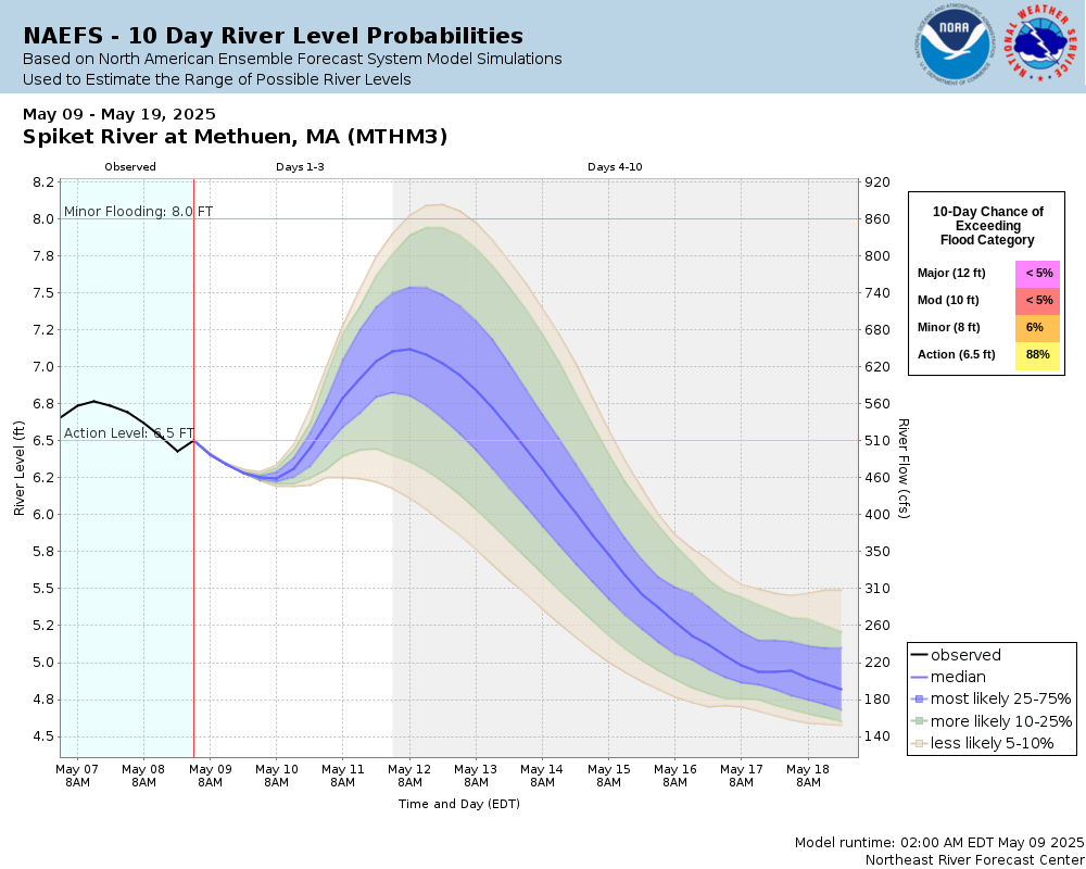
7 Day (NAEFS)
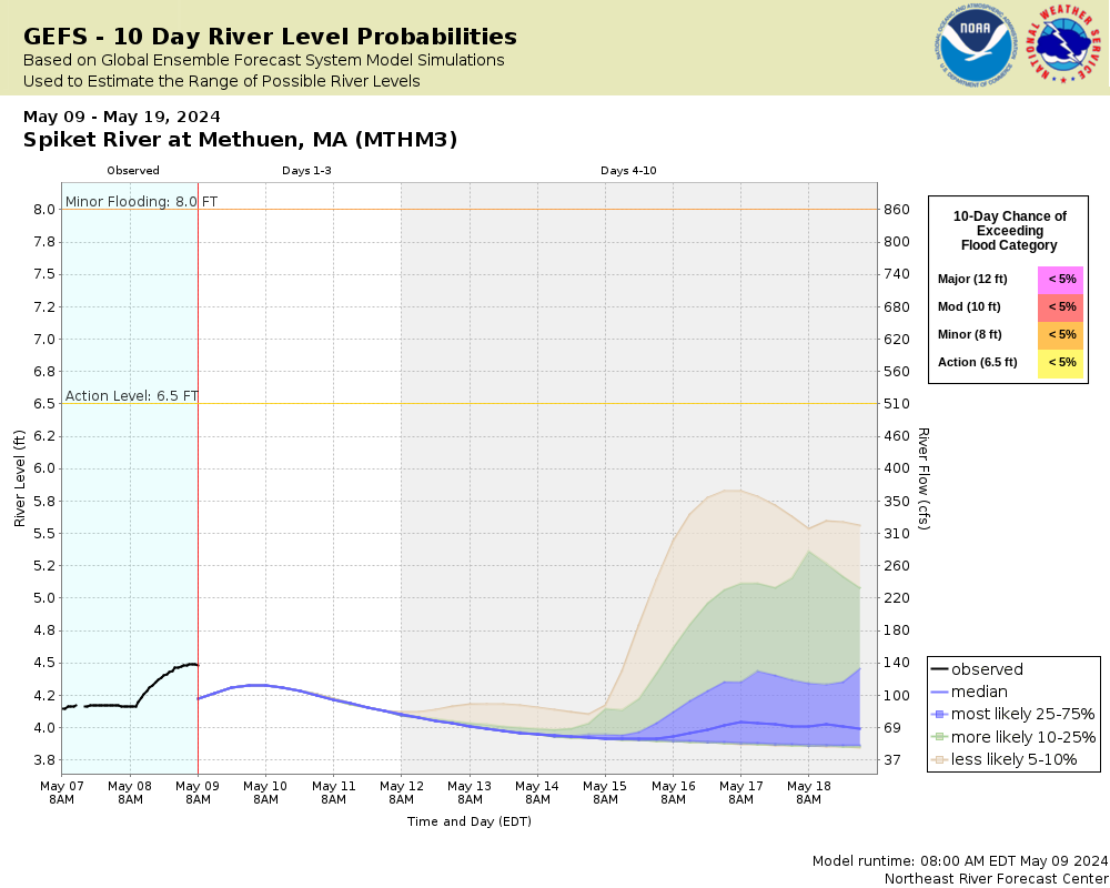
7 Day (GEFS)
Note: Use the official hydrograph at the top of this web page
for river levels within the next 72 hours.
Click individual graphics to
enlarge.
Gage is located on the Salem NH side of the Methuen MA/Salem NH town line.
Collaborative Agencies
The National Weather Service prepares its forecasts and other services in collaboration with agencies like the US Geological Survey, US Bureau of Reclamation, US Army Corps of Engineers, Natural Resource Conservation Service, National Park Service, ALERT Users Group, Bureau of Indian Affairs, and many state and local emergency managers across the country. For details, please click here.
NWS Information
National Weather Service
Boston / Norton Weather Forecast Office
46 Commerce Way
Norton, MA 02766
(508) 622-3250 Ask Questions/Webmaster
Page last modified: 2-Nov-2020 7:30 PM