Skip Navigation Link weather.gov  
NOAA logo - Click to go to the NOAA homepage National Weather Service NWS logo - Click to go to the NWS homepage
Advanced Hydrologic Prediction Service
Image background of Navigation bar Left
Navigation Bar End Cap


This probabilistic forecast is issued by the Southeast River Forecast Center.
tab left off Hydrograph tab right off tab left off River at a Glance tab right off tab left off Download tab right off tab left on tab right on
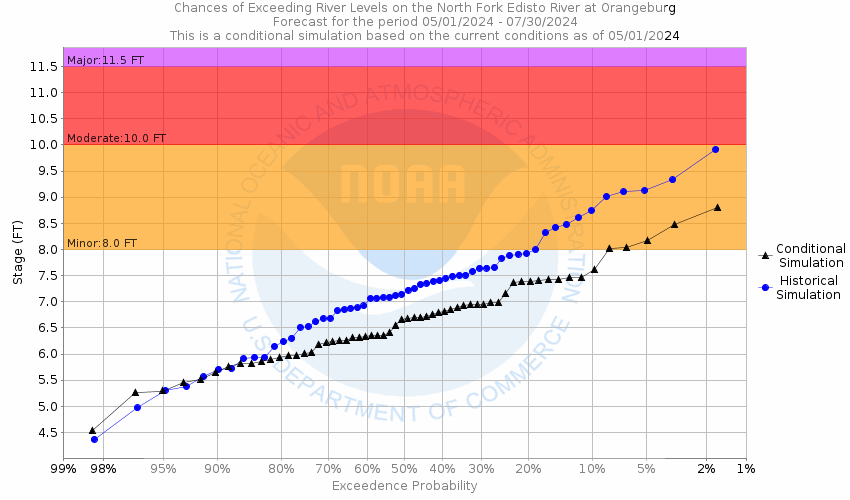
About this graph
Forecasts for the N. Fork Edisto River at Orangeburg are issued routinely year-round.
Return to Area Map

Downstream Gauge Downstream Gauge - near Givhans Ferry
Zoom Level:15
Flood Categories (in feet)
Major Flood Stage: 11.5
Moderate Flood Stage: 10
Flood Stage: 8
Action Stage: 7
Low Stage (in feet): 0

Historic Crests
(1) 14.70 ft on 09/01/1928
(2) 14.28 ft on 09/18/1945
(3) 13.64 ft on 10/06/2015
(4) 11.64 ft on 03/05/1971
(5) 11.56 ft on 09/06/1979
Show More Historic Crests

(P): Preliminary values subject to further review.

Recent Crests
(1) 7.44 ft on 03/07/2024
(2) 6.88 ft on 02/15/2024
(3) 8.86 ft on 06/23/2023
(4) 6.96 ft on 06/12/2023
(5) 8.40 ft on 04/14/2023
Show More Recent Crests

(P): Preliminary values subject to further review.

Low Water Records
(1) 0.87 ft on 08/13/2002
(2) 1.48 ft on 08/23/2007
(3) 1.49 ft on 07/04/2008
(4) 1.68 ft on 09/12/2007
(5) 1.77 ft on 06/03/2000
Show More Low Water Records
KML Image
Gauge LocationGauge Map Marker
Disclaimer
Latitude/Longitude Disclaimer: The gauge location shown in the above map is the approximate location based on the latitude/longitude coordinates provided to the NWS by the gauge owner.
Flood Impacts & Photos Collapse
If you notice any errors in the below information, please contact our Webmaster
14 The dike along the river in the city of Orangeburg will be topped. Extensive areas of the city including US Highway 301 and the Edisto Memorial Gardens will be flooded.
12 Secondary roads near Orangeburg become flooded at stages above 12 ft. Extensive farmland and lowlands downstream from Orangeburg will be flooded.
11 The river exceeds levee diking at stages above 11 ft. Large areas in the city of Orangeburg will be flooded.
10 Farmland and lowlands along Highway 301 near Orangeburg become flooded at stages above 10 ft.
8 Some minor flooding occurs along the boardwalk at Edisto Gardens. Downstream from the Highway 301 bridge, some roads off Chiquita street near the river begin to flood.
Photos
(1) Picture of Old USGS Gage at the Highway 301 bridge.
(2) New USGS Gage location on the Glover Street bridge.
(3) Looking downstream from the Glover Street bridge.
(4) USGS instruments on Glover Street bridge.
(5) Looking upstream from the Glover Street bridge.

Other Real-time and/or Archive Data Sources:

Additional Information Collapse
Potential River Levels - Used to
Potential River Levels
Used to Estimate the Chance of Flooding and the Range of Possible River Levels
10 Day (HEFS) 10 Day (NAEFS) 10 Day (GEFS)
HEFS Ensemble NAEFS Ensemble GEFS Ensemble

Note: Use the official hydrograph at the top of this web page for river levels within the next 72 hours.

Click individual graphics to enlarge.

Data courtesy of the United States Geological Survey.
Collaborative Agencies Collapse
The National Weather Service prepares its forecasts and other services in collaboration with agencies like the US Geological Survey, US Bureau of Reclamation, US Army Corps of Engineers, Natural Resource Conservation Service, National Park Service, ALERT Users Group, Bureau of Indian Affairs, and many state and local emergency managers across the country. For details, please click here.
NWS Information
National Weather Service
Columbia Weather Forecast Office
2909 Aviation Way
West Columbia, SC 29170-2102
(803) 822-8135
Ask Questions/Webmaster
Page last modified: 2-Nov-2020 7:30 PM
Disclaimer
Credits
Glossary
Privacy Policy
About Us
Career Opportunities