Latitude/Longitude Disclaimer: The gauge location shown in the above map
is the approximate location based on the latitude/longitude coordinates
provided to the NWS by the gauge owner.
Flood Impacts & Photos
If you notice any errors in the below information, please contact our Webmaster
18
Hondo Creek floods one to two miles of Highway 90 east of Hondo with a small section at the bridge above water. The area east of the bridge is under several feet of water. Several hundred yards of the Southern Pacific railway is damaged. Highway 173 is flooded north and south of Hondo. Farm to Market 473 north of Hondo is flooded in several places.
17
Highway 90 floods with flow hundreds of yards wide in three sections near Hondo. Highway 173 floods north and south of Hondo. Farm to Market 462 is closed at several low crossings.
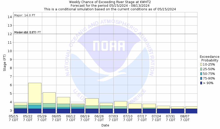
14
Major flooding escapes the main channel into the right and left flood plains approaching Highway 90 east of Hondo and Highway 173 north of Hondo. Farm to Market 462 north of Hondo floods at several low water crossings.
12
Minor lowland flooding inundates Farm to Market 462 at several low crossings over Hondo Creek.
The National Weather Service prepares its forecasts and other services in collaboration with agencies like the US Geological Survey, US Bureau of Reclamation, US Army Corps of Engineers, Natural Resource Conservation Service, National Park Service, ALERT Users Group, Bureau of Indian Affairs, and many state and local emergency managers across the country. For details, please click here.
NWS Information
National Weather Service
Austin/San Antonio Weather Forecast Office
2090 Airport Road
New Braunfels, TX 78130
(830) 629-0130 Ask Questions/Webmaster
Page last modified: 2-Nov-2020 7:29 PM