Latitude/Longitude Disclaimer: The gauge location shown in the above map
is the approximate location based on the latitude/longitude coordinates
provided to the NWS by the gauge owner.
Flood Impacts & Photos
If you notice any errors in the below information, please contact our Webmaster
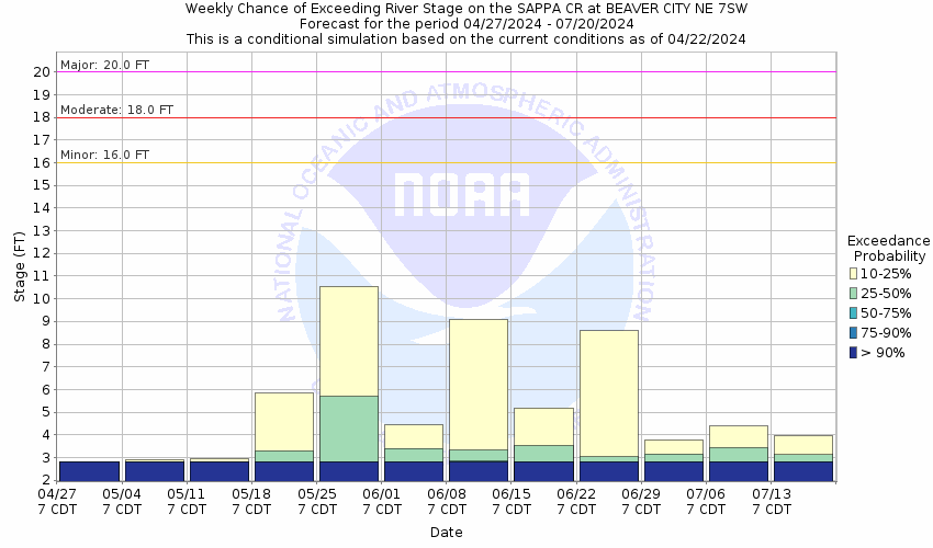
21
Highway 283 south of Beaver City will begin to flood.
20
Lowlands outside the town of Beaver City flood from the overflows of the Sappa Creek and Beaver Creek. A record flood of 20.85 feet occurred in June of 1966. In addition, water reaches the bottom of the bridge at the gage site.
18
Lowland flooding becomes more widespread.
16
The left bank continues to overflow resulting in significant crop and pasture land flooding.
The National Weather Service prepares its forecasts and other services in collaboration with agencies like the US Geological Survey, US Bureau of Reclamation, US Army Corps of Engineers, Natural Resource Conservation Service, National Park Service, ALERT Users Group, Bureau of Indian Affairs, and many state and local emergency managers across the country. For details, please click here.
NWS Information
National Weather Service
Hastings Weather Forecast Office
6365 Osborne Drive West
Hastings, NE 68901
(402) 462-2127 Ask Questions/Webmaster
Page last modified: 2-Nov-2020 7:29 PM


