Latitude/Longitude Disclaimer: The gauge location shown in the above map
is the approximate location based on the latitude/longitude coordinates
provided to the NWS by the gauge owner.
Flood Impacts & Photos
If you notice any errors in the below information, please contact our Webmaster
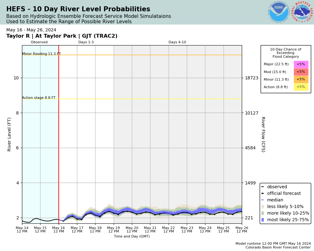
22.5
Water is receding from the lower campsites in Rivers End Campground.
22.5
Water reaches campsites 3 and 4 in Rivers End Campground. Several homes along left bank destroyed. Taylor Dam needs to be monitored.
15
Major flooding and damage to home on left bank near intersection of FR 742 and Cow Trail Road and to home near intersection of FR 742 and Illinois Creek Road. Taylor Park Dam needs to be monitored.
11.3
Water is receding from house on left bank near intersection of FR 742 and Cow Trail Road
11.3
The Taylor River reaches the foundation of the house on the left bank near the intersection of FR 742 and Cow Trail Road. Sections of FR 742 flooded. Low-lying property along left bank flooded. Taylor Park Dam needs to be monitored.
8.8
Lower portions of FR 742 near intersection with Illinois Creek Road along the Taylor River begin to flood. House on left bank near Illinois Creek begins to flood.
5.09
Water reaches the top of the right bank.
3.6
Water reaches the top of the left bank. The river gage site begins to flood.
The National Weather Service prepares its forecasts and other services in collaboration with agencies like the US Geological Survey, US Bureau of Reclamation, US Army Corps of Engineers, Natural Resource Conservation Service, National Park Service, ALERT Users Group, Bureau of Indian Affairs, and many state and local emergency managers across the country. For details, please click here.
NWS Information
National Weather Service
Grand Junction Weather Forecast Office
2844 Aviators Way
Grand Junction, CO 81506
(970) 243-7007 Ask Questions/Webmaster
Page last modified: 2-Nov-2020 7:28 PM