Historic Crests
(1) 20.19 ft on 09/22/2018
(2) 17.94 ft on 09/23/1999
(3) 16.95 ft on 10/14/2016
(4) 15.17 ft on 10/06/2015
(5) 14.95 ft on 09/15/1996 Show More Historic Crests
(P): Preliminary values subject to further review.
Recent Crests
(1) 14.34 ft on 02/23/2021
(2) 10.84 ft on 02/08/2021
(3) 10.56 ft on 02/02/2021
(4) 12.03 ft on 01/09/2021
(5) 12.08 ft on 11/21/2020 Show More Recent Crests
(P): Preliminary values subject to further review.
Low Water Records (1) 0.10 ft on 07/23/2011 (2) 0.39 ft on 07/21/2002 (3) 0.46 ft on 09/24/2010 (4) 0.55 ft on 10/16/2007 (5) 0.65 ft on 08/22/2007 Show More Low Water Records
Latitude/Longitude Disclaimer: The gauge location shown in the above map
is the approximate location based on the latitude/longitude coordinates
provided to the NWS by the gauge owner.
Flood Impacts & Photos
If you notice any errors in the below information, please contact our Webmaster
20
Extensive flooding. Numerous roads flooded and areas isolated by flooding. HWY 9 near longs and multiple spots on HWY 905 may be impassable. Flooding along Vera LN and Star Bluff RD expands to Pint CIR and areas near the North Myrtle Beach Drag Strip. Several buildings between HWY 905 and HWY 90 and HWY 57 may be flooded or isolated.In NC,River RD in Pireway inaccessible. HWY 905 S of Pireway and other spots on Ash-Little River RD flood. Parts of Brunswick Plantation on Caw Caw Swamp will flood.
19
Extensive flooding. Many roads flooded and areas isolated by flooding. Hwy 905 between McNeil Chapel RD and Parker RD impassable. HWY 9 near Longs and HWY 905 at Buck Creek flooded. Flooding expands along Vera LN and Star Bluff RD. Several roads in Aberdeen flooded. Rolling River RD,Loop CIR, Dusty LN,and Thomas RD near Huston RD will flood. In NC,River RD in Pireway inaccessible. HWY 905 S of Pireway and other spots on Ash-Little River RD flood. Parts of Brunswick Plantation on Caw Caw Swamp may flood.
18
Extensive flooding. Many roads flooded and areas isolated by flooding. Hwy 905 between McNeil Chapel RD and Parker RD may be impassable. Flooding expands along Vera LN and Star Bluff RD. Several roads in Aberdeen will be flooded or begin to flood. Rolling River RD will flood. Loop CIR, Dusty LN,and Thomas RD near Huston RD may flood. HWY 9 near Longs and HWY 905 near Buck Creek will flood. In NC,River RD in Pireway is inaccessible. HWY 905 south of Pireway and multiple spots of Ash-Little River RD flood.
17
Homes isolated along Lure CT,the end of Vera LN,and the ends of Big Gutter and Doodle Hill LN. Red Bluff RD impassable. HWY 905 and streets between Council Bluff RD and Parker RD flood. Bucks TRL,Tupelo LN,Canipe CIR,Waccamaw CIR near Pint and Loop CIR,Crystal LN,areas along Holly Ridge DR and Meadowood LN,the end of Star Bluff RD,and along HWY 9 flood. HWY 9 and Rolling River RD may flood. In NC,River RD in Pireway impassable. Ash-Little River RD at Caw Caw Swamp floods. HWY 905 south of Pireway may flood.
16
Homes isolated along Lure CT,Canipe CIR,the end of Vera LN,and the ends of Big Gutter and Doodle Hill LN. Red Bluff RD will be impassable. HWY 905 and streets between Council Bluff RD and Parker RD begin to flood. Waccamaw CIR near Pint CIR,areas at the end of Star Bluff RD,along Waccamaw LN near Loop CIR,the end of Crystal LN,and along HWY 9 flood. Bucks TRL,Tupelo LN,areas along Holly Ridge DR and Meadowood LN may be flooded. In NC,River RD in Pireway and Ash-Little River RD flood.
15
Homes isolated along Lure CT, Canipe CIR,and at the ends of Big Gutter and Doodle Hill LN. Red Bluff RD is impassable. Areas along HWY 905 between Council Bluff RD and Parker RD,along Waccamaw LN near Loop CIR,Holly Ridge DR,and along HWY 9 will flood. The ends of Vera LN,Star Bluff RD,and Crystal LN flood. Bucks TRL may be flooded. In NC,River RD in Pireway will flood. Low areas between the river and Ash-Little River RD will flood. Ash-Little River RD near Caw Caw Swamp begin to flood.
14
Homes isolated at the ends of Big Gutter LN, Doodle Hill LN, and along Lure CT. Red Bluff RD may be impassable. Yards along HWY 905 may begin to flood between Council Bluff RD and Parker RD. The end of Vera LN is isolated by flood waters. Areas near the end of Star Bluff RD begin to flood. Areas along Waccamaw LN near Loop CIR begin to flood. Parts of Canipe CIR will flood. Low areas along HWY 9 will flood. In NC,River RD in Pireway will flood. Low areas between the river and Ash-Little River will flood.
13
A few homes may be isolated by flood waters near the river at the end of Big Gutter Lane and Doodle Hill Lane. Flooding on Red Bluff Road worsens. The end of Vera Lane may be isolated by flood waters. Aberdeen Country Club parking lot may flood. In North Carolina, River Road in Pireway may begin to flood.
12
Flooding may limit vehicle access near the river at the end of Big Gutter Lane and Doodle Hill Lane. Low spots on Red Bluff Road will begin to flood. The end of Vera Road will flood. Several boat landings will become inaccessible. Parts of Aberdeen County Club will be flooded.
11
Water spreads further into swamps and lowlands along the river and flooding at boat landings worsens.
10
Water will spread into swamps along the river and a few boat landings will begin to flood.
Potential River Levels Used to Estimate the Chance of Flooding and
the Range of Possible River Levels
10 Day (HEFS)
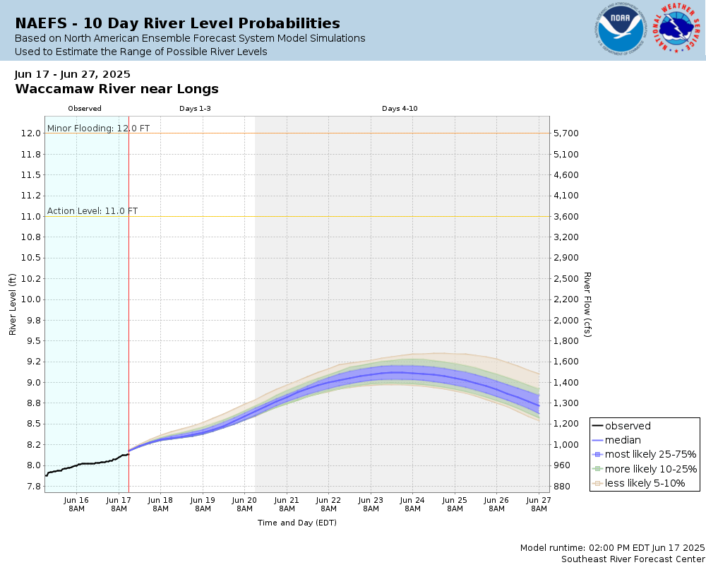
10 Day (NAEFS)
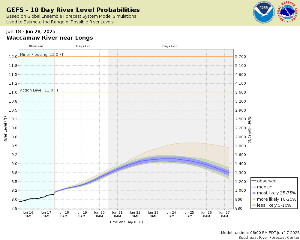
10 Day (GEFS)
Note: The official hydrograph at the top of this web page was made by a river forecaster using past rainfall and forecast rainfall for the next 48 hours. The Potential River Level graphics are computer generated and most useful for rain expected beyond 48 hours.
Collaborative Agencies
The National Weather Service prepares its forecasts and other services in collaboration with agencies like the US Geological Survey, US Bureau of Reclamation, US Army Corps of Engineers, Natural Resource Conservation Service, National Park Service, ALERT Users Group, Bureau of Indian Affairs, and many state and local emergency managers across the country. For details, please click here.
NWS Information
National Weather Service
Wilmington Weather Forecast Office
2015 Gardner Drive
Wilmington, NC 28405
(910) 762-4289 Ask Questions/Webmaster
Page last modified: 2-Nov-2020 7:30 PM