Skip Navigation Link weather.gov  
NOAA logo - Click to go to the NOAA homepage National Weather Service NWS logo - Click to go to the NWS homepage
Advanced Hydrologic Prediction Service
Image background of Navigation bar Left
Navigation Bar End Cap


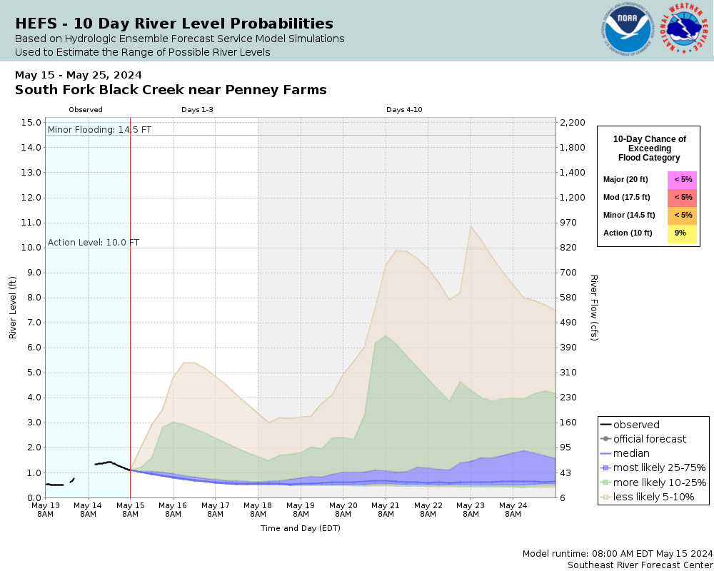
This probabilistic forecast is issued by the Southeast River Forecast Center.
tab left off Hydrograph tab right off tab left off River at a Glance tab right off tab left off Download tab right off tab left on tab right on
Experimental Short Range Forecast Uncertainty (AHPS) - External Links: Product Description Document | Customer Survey
About this graph
Forecasts for the South Fork Black Creek near Penney Farms are issued as needed during times of high water, but are not routinely available.

More information on datums is available at www.ngs.noaa.gov/faq.shtml

Return to Area Map

Zoom Level:14
Flood Categories (in feet)
Major Flood Stage: 20
Moderate Flood Stage: 17.5
Flood Stage: 14.5
Action Stage: 10
Low Stage (in feet): 0.5

Historic Crests
(1) 29.36 ft on 09/11/2017
(2) 26.33 ft on 10/19/1944
(3) 25.21 ft on 05/21/1959
(4) 23.68 ft on 05/03/2013
(5) 22.71 ft on 02/03/1970
(6) 22.60 ft on 09/24/1947
(7) 22.57 ft on 04/27/1997
(8) 22.03 ft on 09/30/1969
(9) 21.65 ft on 10/21/1941
(10) 21.25 ft on 10/19/1950
Show More Historic Crests

(P): Preliminary values subject to further review.

Recent Crests
(1) 15.28 ft on 12/18/2023
(2) 15.88 ft on 03/12/2022
(3) 15.33 ft on 07/08/2021
(4) 14.69 ft on 05/31/2018
(5) 29.36 ft on 09/11/2017
(6) 14.85 ft on 06/28/2017
(7) 16.51 ft on 10/08/2016
(8) 14.99 ft on 09/01/2015
(9) 15.33 ft on 08/31/2015
(10) 16.29 ft on 07/13/2014
Show More Recent Crests

(P): Preliminary values subject to further review.

Low Water Records
(1) -0.07 ft on 05/30/2007
(2) -0.05 ft on 08/24/2007
(3) -0.03 ft on 06/11/2007
(4) -0.01 ft on 05/27/2012
(5) 0.01 ft on 06/23/2011
Show More Low Water Records
KML Image
Gauge LocationGauge Map Marker
Disclaimer
Latitude/Longitude Disclaimer: The gauge location shown in the above map is the approximate location based on the latitude/longitude coordinates provided to the NWS by the gauge owner.
Flood Impacts & Photos Collapse
If you notice any errors in the below information, please contact our Webmaster
20 Significant flooding of homes and property along the entire South Fork Basin begin. This includes property along Creek Street, Black Creek Drive and Lightning Lane. Thunder Road and other main access roads along the creek become impassable. Evacuations in low lying areas are expected.
17.5 Flooding begins to impact numerous homes and structures along Creek Street, Black Creek Drive and Lightning Lane. Access to homes will be cut off by flood waters. Evacuations in low lying areas may be necessary.
16 Flooding of low lying structures along Creek Street begins. Creek Street and driveways leading to Black Creek Drive become impassable. Movement of property to higher ground is recommended.
14.5 Flooding begins to impact low lying driveways and access roads along Creek Street, Black Creek Drive and Lightning Lane. Docks and other low lying property along the creek begin to flood.
10 Should water levels continue rising, preparations to protect property should begin.

Other Real-time and/or Archive Data Sources:

Additional Information Collapse
HEFS Ensemble NAEFS Ensemble GEFS Ensemble
Collaborative Agencies Collapse
The National Weather Service prepares its forecasts and other services in collaboration with agencies like the US Geological Survey, US Bureau of Reclamation, US Army Corps of Engineers, Natural Resource Conservation Service, National Park Service, ALERT Users Group, Bureau of Indian Affairs, and many state and local emergency managers across the country. For details, please click here.
NWS Information
National Weather Service
Jacksonville Weather Forecast Office
13701 Fang Drive
Jacksonville, FL 32218
(904) 741-4370
Ask Questions/Webmaster
Page last modified: 2-Nov-2020 7:30 PM
Disclaimer
Credits
Glossary
Privacy Policy
About Us
Career Opportunities