Skip Navigation Link weather.gov  
NOAA logo - Click to go to the NOAA homepage National Weather Service NWS logo - Click to go to the NWS homepage
Advanced Hydrologic Prediction Service
Image background of Navigation bar Left
Navigation Bar End Cap


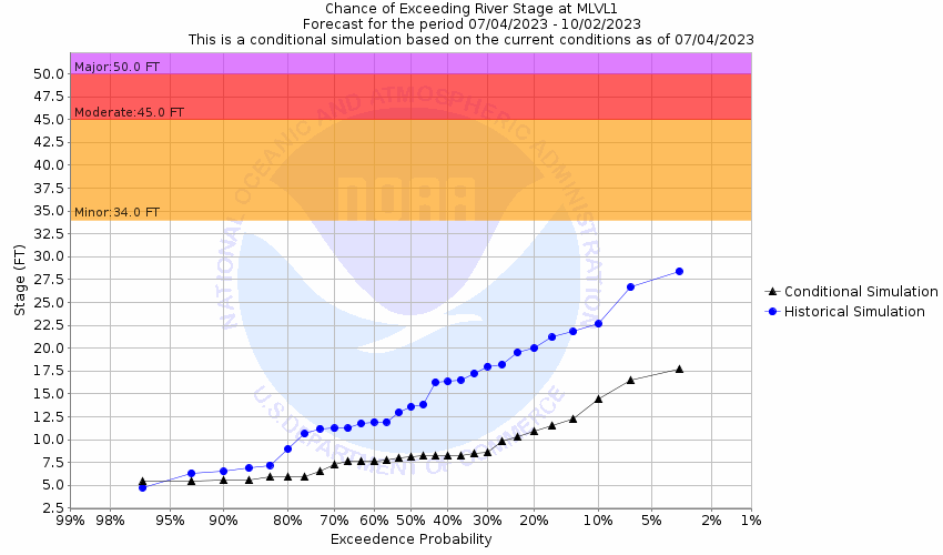
This probabilistic forecast is issued by the Lower Mississippi River Forecast Center.
tab left off Hydrograph tab right off tab left off River at a Glance tab right off tab left off Download tab right off tab left on tab right on
About this graph
Forecasts for the Atchafalaya River at Melville are issued routinely year-round.
Return to Area Map

Upstream Gauge - at Simmesport Upstream Gauge Downstream Gauge Downstream Gauge - at Krotz Springs
Zoom Level:16
Flood Categories (in feet)
Major Flood Stage: 50
Moderate Flood Stage: 45
Flood Stage: 34
Action Stage: 33
Low Stage (in feet): 0

Historic Crests
(1) 46.98 ft on 05/14/1927
(2) 46.08 ft on 05/14/1922
(3) 45.88 ft on 04/25/1945
(4) 45.00 ft on 03/05/1950
(5) 44.98 ft on 03/02/1937
Show More Historic Crests

(P): Preliminary values subject to further review.

Recent Crests
(1) 24.61 ft on 03/24/2022
(2) 27.39 ft on 04/16/2021
(3) 31.07 ft on 04/13/2020
(4) 32.90 ft on 03/15/2019
(5) 32.88 ft on 03/19/2018
Show More Recent Crests

(P): Preliminary values subject to further review.

Low Water Records
(1) 0.80 ft on 01/19/1981
(2) 0.88 ft on 06/23/1964
(3) 0.90 ft on 10/18/1976
Show More Low Water Records
KML Image
Gauge LocationGauge Map Marker
Disclaimer
Latitude/Longitude Disclaimer: The gauge location shown in the above map is the approximate location based on the latitude/longitude coordinates provided to the NWS by the gauge owner.
Flood Impacts & Photos Collapse
If you notice any errors in the below information, please contact our Webmaster
52.5 The water level will be near the top of the levee which is 53 feet at its lowest point.
50 Water will reach the base of the Texas Pacific railroad bridge girders.
48 The water level will reach the grade level of the lowest elevation on the back side of the Melville ring levee.
45 Considerable flooding occurs.
41 Flooding will begin on the river side of the river levee and on the river side of the Melville protection ring levee. Increased river current will make navigation more difficult and increase the need for strict traffic regulation.
36 Flooding of structures on the unprotected side of the levee begins along Trestle Street and River Bank Road in Melville.
34 Lowest structures on the unprotected side of the levee begin to flood. Flooding is more extensive just south of melville.
33 Action stage.
30 Increased current in the atchafalaya main channel will cause minor navigation problems for large craft, but hazardous conditions for smaller river craft. The average elevation within the protection of the melville ring levee is 31 feet.
25 Flooding will begin on the river side of the atchafalaya river levee and the melville ring levee which protect the city to a river stage of about 50 feet.

Other Real-time and/or Archive Data Sources:

Collaborative Agencies Collapse
The National Weather Service prepares its forecasts and other services in collaboration with agencies like the US Geological Survey, US Bureau of Reclamation, US Army Corps of Engineers, Natural Resource Conservation Service, National Park Service, ALERT Users Group, Bureau of Indian Affairs, and many state and local emergency managers across the country. For details, please click here.
NWS Information
National Weather Service
Lake Charles Weather Forecast Office
500 Airport Boulevard
Lake Charles, LA 70607
(337) 477-5285
Ask Questions/Webmaster
Page last modified: 2-Nov-2020 7:29 PM
Disclaimer
Credits
Glossary
Privacy Policy
About Us
Career Opportunities