Latitude/Longitude Disclaimer: The gauge location shown in the above map
is the approximate location based on the latitude/longitude coordinates
provided to the NWS by the gauge owner.
Flood Impacts & Photos
If you notice any errors in the below information, please contact our Webmaster
40
Widespread flooding continues to impact areas along the river and adjacent tributaries. Many roads are flooded and impassable in and around Ashland City and northeast Dickson County, including Route 251, Route 249, and Route 12 east of Ashland City. In Ashland City, locations on Elizabeth St, Lindahl Pkwy, Rhea St, Tennessee Waltz Pkwy, North Vine St, and Water St are flooded.
38
Widespread flooding along the river and adjacent tributaries continues to impact agricultural, residential, and industrial areas in and around Ashland City and northeast Dickson County. Many primary roads near the river are flooded and impassable, including portions of Route 251 and Route 249. In Ashland City, locations on Elizabeth St, Lindahl Pkwy, Rhea St, Tennessee Waltz Pkwy, North Vine St, and Water St are flooded, and water approaches Route 12 east of town.
36
Widespread flooding along the river and adjacent tributaries continues to impact agricultural, residential and industrial areas in and around Ashland City and northeast Dickson County. Many primary roads near the river are flooded and impassable, including portions of Route 251 between Pond Creek and Sams Creek, and Route 249 at Brush Creek and Sams Creek. In Ashland City, locations on Elizabeth St, Lindahl Pkwy, Rhea St, Tennessee Waltz Pkwy, North Vine St, and Water St are flooded.
35
Water begins to approach Water St in Ashland City, and Route 249 between Brush Creek and Sams Creek. Flooding of adjacent tributaries continues, including portions of the Harpeth River, Marrowbone Creek, Little Marrowbone Creek including the Walmart shopping center, and Sycamore Creek.
34
Significant flooding continues to impact areas along the river, including Chapmansboro Rd, Cheatham Dam Rd, Cumberland Dr, Floy Lane, Goose Bay Rd, Graham Rd, Jamestown Rd, Johnson Creek Rd, Lakeside Dr, Lindahl Pkwy, Matlock Dr, Meadowbrook Rd, Pond Creek Rd, Riverview Dr, River Trace, Sunrise Circle, Tennessee Waltz Pkwy, Thompson Rd, Trinity Rd, Wayne Jackson Rd, and Willowbrook Dr. Route 251 is flooded between Pond Creek and Sams Creek.
32
Significant flooding is occurring along the river, impacted locations include Chapmansboro Rd, Cheatham Dam Rd, Cumberland Dr, Floy Lane, Goose Bay Rd, Graham Rd, Jamestown Rd, Johnson Creek Rd, Lakeside Dr, Lindahl Pkwy, Matlock Dr, Meadowbrook Rd, Pond Creek Rd, Riverview Dr, River Trace, Sunrise Circle, Tennessee Waltz Pkwy, Thompson Rd, Trinity Rd, Wayne Jackson Rd, and Willowbrook Dr. Route 251 near Pond Creek and Sams Creek is flooded and may be impassable.
30
Agricultural, residential and industrial areas near the river continue to be impacted, including Chapmansboro Rd, Cheatham Dam Rd, Cumberland Dr, Floy Lane, Goose Bay Rd, Graham Rd, Jamestown Rd, Johnson Creek Rd, Lakeside Dr, Lindahl Pkwy, Matlock Dr, Meadowbrook Rd, Pond Creek Rd, Riverview Dr, River Trace, Sunrise Circle, Tennessee Waltz Pkwy, Thompson Rd, Trinity Rd, Wayne Jackson Rd, and Willowbrook Rd. Water approaches Route 251 near Pond Creek and Sams Creek.
28
Roads and properties in agrcultural, residential and industrial areas near the river are impacted, including Chapmansboro Rd, Cheatham Dam Rd, Cumberland Dr, Goose Bay Rd, Graham Rd, Jamestown Rd, Johnson Creek Rd, Lakeside Dr, Lindahl Pkwy, Matlock Dr, Meadowbrook Rd, Pond Creek Rd, River Trace, Sunrise Circle, Tennessee Waltz Pkwy, Thompson Rd, Trinity Rd, Wayne Jackson Rd, and Willowbrook Dr. Water approaches Riverview Dr, Floy Lane, and adjacent tributaries.
26
Low lying and agricultural areas are inundated near Brush Creek, Jamestown Rd, Sunrise Circle, and Sycamore Creek. Water approaches roads and properties in residential and industrial areas near the river on Chapmansboro Rd, Cheatham Dam Rd, Goose Bay Rd, Jamestown Rd, Lakeside Dr, Lindahl Pkwy, Matlock Dr, Meadowbrook Rd, Pond Creek Rd, River Trace, Tennessee Waltz Pkwy, Thompson Rd, Trinity Rd, and Willowbrook Dr.
24
Low lying areas along the river, agricultural areas, and access points at Brush Creek, Cheatham Dam Rd, Jamestown Rd, Sunrise Circle, and the Sycamore Creek Recreation Area begin to be inundated. Backwater effects are also causing inundation along adjacent tributaries, including the Harpeth River, Marrowbone Creek, and Sycamore Creek.
Potential River Levels Used to Estimate the Chance of Flooding and
the Range of Possible River Levels
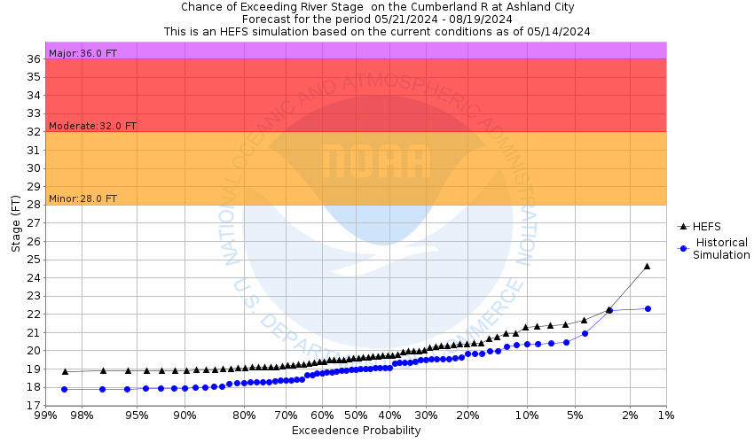
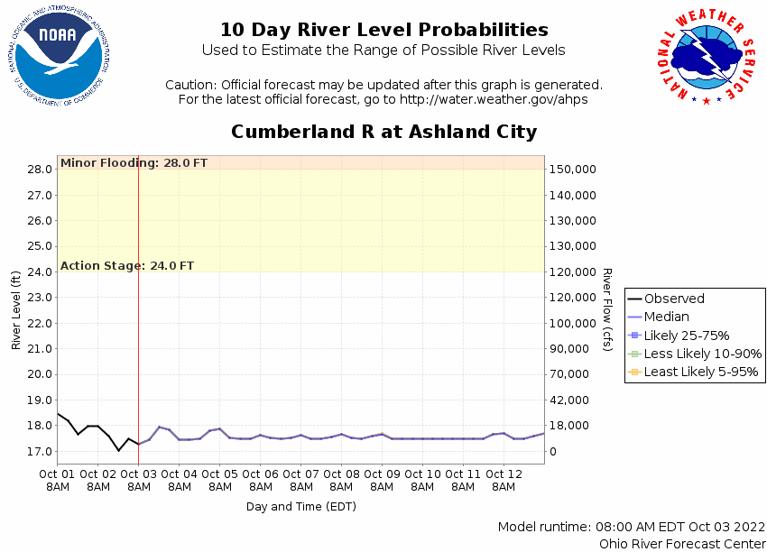
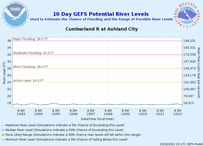
10 Day (HEFS)
7 Day (NAEFS)
7 Day (GEFS)
Note: Use the official hydrograph at the top of this web page
for river levels within the next 72 hours.
Click individual graphics to
enlarge.
Collaborative Agencies
The National Weather Service prepares its forecasts and other services in collaboration with agencies like the US Geological Survey, US Bureau of Reclamation, US Army Corps of Engineers, Natural Resource Conservation Service, National Park Service, ALERT Users Group, Bureau of Indian Affairs, and many state and local emergency managers across the country. For details, please click here.
NWS Information
National Weather Service
Nashville Weather Forecast Office
500 Weather Station Road
Old Hickory, TN 37138
(615) 754-4633 Ask Questions/Webmaster
Page last modified: 2-Nov-2020 7:29 PM