Skip Navigation Link weather.gov  
NOAA logo - Click to go to the NOAA homepage National Weather Service NWS logo - Click to go to the NWS homepage
Advanced Hydrologic Prediction Service
Image background of Navigation bar Left
Navigation Bar End Cap


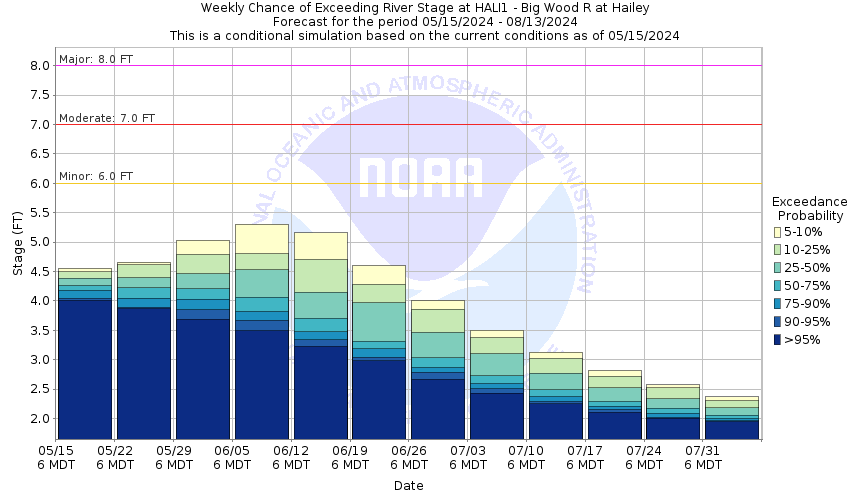
This probabilistic forecast is issued by the Northwest River Forecast Center.
tab left off Hydrograph tab right off tab left off River at a Glance tab right off tab left off Download tab right off tab left on tab right on
About this graph
Forecasts for the Big Wood River at Hailey are issued routinely year-round.
Return to Area Map

Zoom Level:15
Flood Categories (in feet)
Major Flood Stage: 8
Moderate Flood Stage: 7
Flood Stage: 6
Action Stage: 5
Low Stage (in feet): -9999

Historic Crests
(1) 8.36 ft on 05/07/2017
(2) 7.93 ft on 05/30/1983
(3) 7.92 ft on 05/21/2006
(4) 7.72 ft on 05/25/1967
(5) 7.20 ft on 06/16/1974
Show More Historic Crests

(P): Preliminary values subject to further review.

Recent Crests
(1) 5.52 ft on 06/13/2022
(2) 3.44 ft on 06/05/2021
(3) 4.01 ft on 05/31/2020
(4) 5.90 ft on 06/07/2019
(5) 5.12 ft on 05/26/2018
Show More Recent Crests

(P): Preliminary values subject to further review.

Low Water Records
(1) -0.02 ft on 02/24/1969
(2) 0.23 ft on 01/21/1967
(3) 0.24 ft on 01/24/1965
Show More Low Water Records
KML Image
Gauge LocationGauge Map Marker
Disclaimer
Latitude/Longitude Disclaimer: The gauge location shown in the above map is the approximate location based on the latitude/longitude coordinates provided to the NWS by the gauge owner.
Flood Impacts & Photos Collapse
If you notice any errors in the below information, please contact our Webmaster
8 Numerous locations from the confluence of Warm Springs Creek downstream to Bellevue will have flooding problems. Many roads may be inaccessible and many houses and infrastructure will be impacted. Significant floodingin Cedar, War Eagle, and Della Vista Drives in the lower subdivisions in Hailey area will be inaccessible. Flooding in Riverview Drive area of Bellevue. Draper Preserve in Hailey is inaccessible. Water may be over some secondary roads in West Ketchum (Wood River Drive).
7 Moderate flooding will occur along Cedar, War Eagle, and Della Vista Drives in the lower subdivisions in Hailey which may be inaccessible. FLooding in Riverview Drive area of Bellevue. Draper Preserve in Hailey is inaccessible. Water may be over some secondary roads in West Ketchum (Wood River Drive). Gimlet subdivision will have some residents with flooding issues.
6 Street flooding will occur along Cedar, War Eagle, and Della Vista Drives in the lower subdivisions in Hailey and Riverview drive in Bellevue. Draper Preserve in Hailey is inaccessible. Water may be over some secondary roads in West Ketchum (Wood River Drive). Gimlet subdivision will have flooding issues.
5 Near bankfull from Ketchum down-river to Glendale Road Bridge south of Bellevue. Some lowland seepage and ponding is possible in residential areas near the river especially in the Della View subdivision on far western War Eagle Drive. Gimlet subdivision may experience ponding.
Photos
(1) HALI1_googleearth
(2) HALI1_map
(3) HALI1_satellite_view
(4) HALI1_google_maps_streetviewofgage
(5) HALI1_bridge_gagehouse_looking_east
(6) HALI1_looking_upstream_winter
(7) HALI1_looking_downstream_winter
(8) HALI1_looking_upstream_summer
(9) HALI1_looking_downstream_summer
(10) HALI1_High_Flow_July_2006

Other Real-time and/or Archive Data Sources:

Additional Information Collapse
Big Wood River at Hailey USGS Webcam

Big Wood River Flood Inundation Maps from the U.S. Army Corps of Engineers

USGS Historical Peak Flows     (Scroll to Streamflow Statistics for more years)
USGS Historical Peak Flows Explanation
Graphical View of Historical Peak Flows and Gage Analysis 
25   Year Peak Flood 5530 CFS or 7.94 ft
50   Year Peak Flood 6370 CFS or 8.57 ft
100 Year Peak Flood 7210 CFS or 9.17 ft
200 Year Peak Flood 8050 CFS or 9.75 ft
500 Year Peak Flood 9190 CFS or 10.49 ft
Collaborative Agencies Collapse
The National Weather Service prepares its forecasts and other services in collaboration with agencies like the US Geological Survey, US Bureau of Reclamation, US Army Corps of Engineers, Natural Resource Conservation Service, National Park Service, ALERT Users Group, Bureau of Indian Affairs, and many state and local emergency managers across the country. For details, please click here.
NWS Information
National Weather Service
Pocatello Weather Forecast Office
1945 Beechcraft Ave
Pocatello, ID 83204
(208) 232-9306
Ask Questions/Webmaster
Page last modified: 2-Nov-2020 7:28 PM
Disclaimer
Credits
Glossary
Privacy Policy
About Us
Career Opportunities