Skip Navigation Link weather.gov  
NOAA logo - Click to go to the NOAA homepage National Weather Service NWS logo - Click to go to the NWS homepage
Advanced Hydrologic Prediction Service
Image background of Navigation bar Left
Navigation Bar End Cap


This probabilistic forecast is issued by the Colorado Basin River Forecast Center.
tab left off Hydrograph tab right off tab left off River at a Glance tab right off tab left off Download tab right off tab left on tab right on
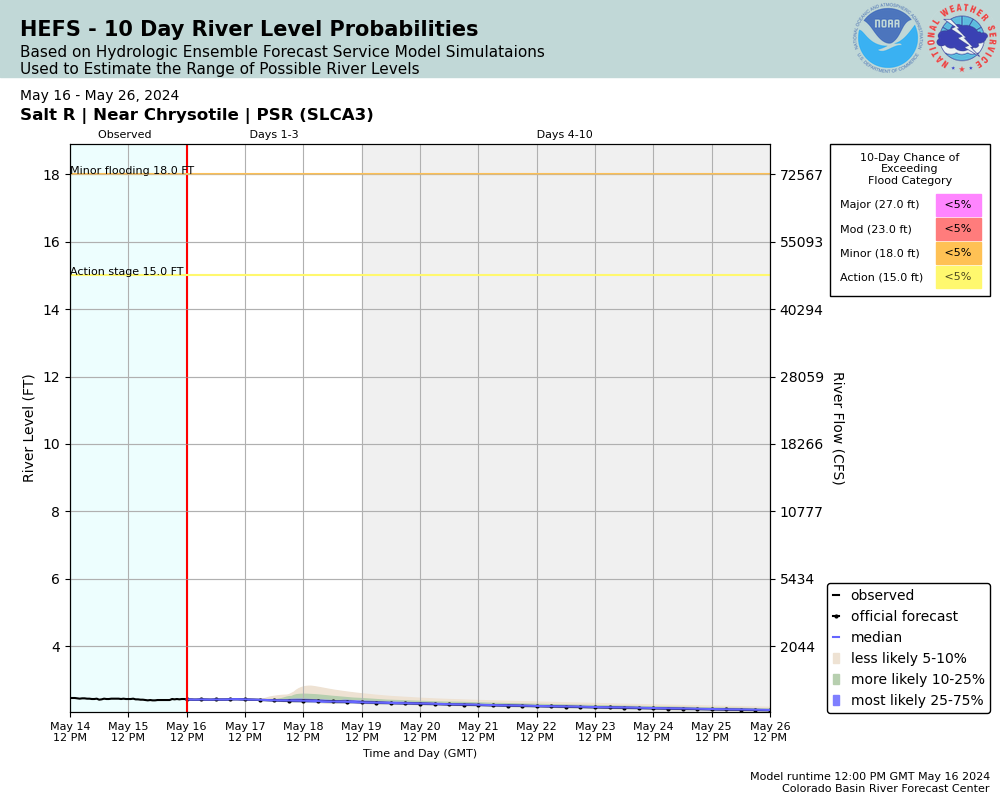
Experimental Short Range Forecast Uncertainty (AHPS) - External Links: Product Description Document | Customer Survey
About this graph
Forecasts for the Salt River near Chrysotile -Salt River Canyon are issued routinely year-round.
Return to Area Map

Downstream Gauge Downstream Gauge - near Roosevelt
Zoom Level:16
Flood Categories (in feet)
Major Flood Stage: 27
Moderate Flood Stage: 23
Flood Stage: 18
Action Stage: 15
Low Stage (in feet): -9999

Historic Crests
(1) 18.33 ft on 01/08/1993
(2) 18.00 ft on 01/19/1916
(3) 17.35 ft on 12/18/1978
(4) 16.06 ft on 02/15/1980
(5) 15.94 ft on 01/28/2008
(6) 15.84 ft on 10/02/1983
(7) 15.18 ft on 02/07/1937
(8) 15.10 ft on 03/02/1978
(9) 15.08 ft on 03/14/1941
(10) 15.00 ft on 01/14/1952
Show More Historic Crests

(P): Preliminary values subject to further review.

Recent Crests
(1) 13.44 ft on 01/22/2010
(2) 15.94 ft on 01/28/2008
(3) 12.47 ft on 02/12/2005
(4) 18.33 ft on 01/08/1993
(5) 13.71 ft on 03/02/1991
(6) 12.88 ft on 12/28/1984
(7) 15.84 ft on 10/02/1983
(8) 16.06 ft on 02/15/1980
(9) 17.35 ft on 12/18/1978
(10) 15.10 ft on 03/02/1978
Show More Recent Crests

(P): Preliminary values subject to further review.

Low Water Records
(1) 1.00 ft on 07/06/1955
KML Image
Gauge LocationGauge Map Marker
Disclaimer
Latitude/Longitude Disclaimer: The gauge location shown in the above map is the approximate location based on the latitude/longitude coordinates provided to the NWS by the gauge owner.
Flood Impacts & Photos Collapse
If you notice any errors in the below information, please contact our Webmaster
75 Water reaches the US 60 Highway bridge.
70 The bottom of the rest area main building floods.
45 The USGS wellhouse begins flooding.
37 The rest area, lower picnic areas, and the lower pathway to the gage flood.
27 Major flooding occurs.
23 Moderate flooding occurs.
18.32 Flow of record, recorded January 8, 1993, 76,600 cfs
18 Flood stage
16 Bankfull
15 Alert stage

Other Real-time and/or Archive Data Sources:

Collaborative Agencies Collapse
The National Weather Service prepares its forecasts and other services in collaboration with agencies like the US Geological Survey, US Bureau of Reclamation, US Army Corps of Engineers, Natural Resource Conservation Service, National Park Service, ALERT Users Group, Bureau of Indian Affairs, and many state and local emergency managers across the country. For details, please click here.
NWS Information
National Weather Service
Phoenix Weather Forecast Office
2727 E Washington St PAB 1TA
Phoenix, AZ 85034
(602) 275-0073
Ask Questions/Webmaster
Page last modified: 2-Nov-2020 7:30 PM
Disclaimer
Credits
Glossary
Privacy Policy
About Us
Career Opportunities